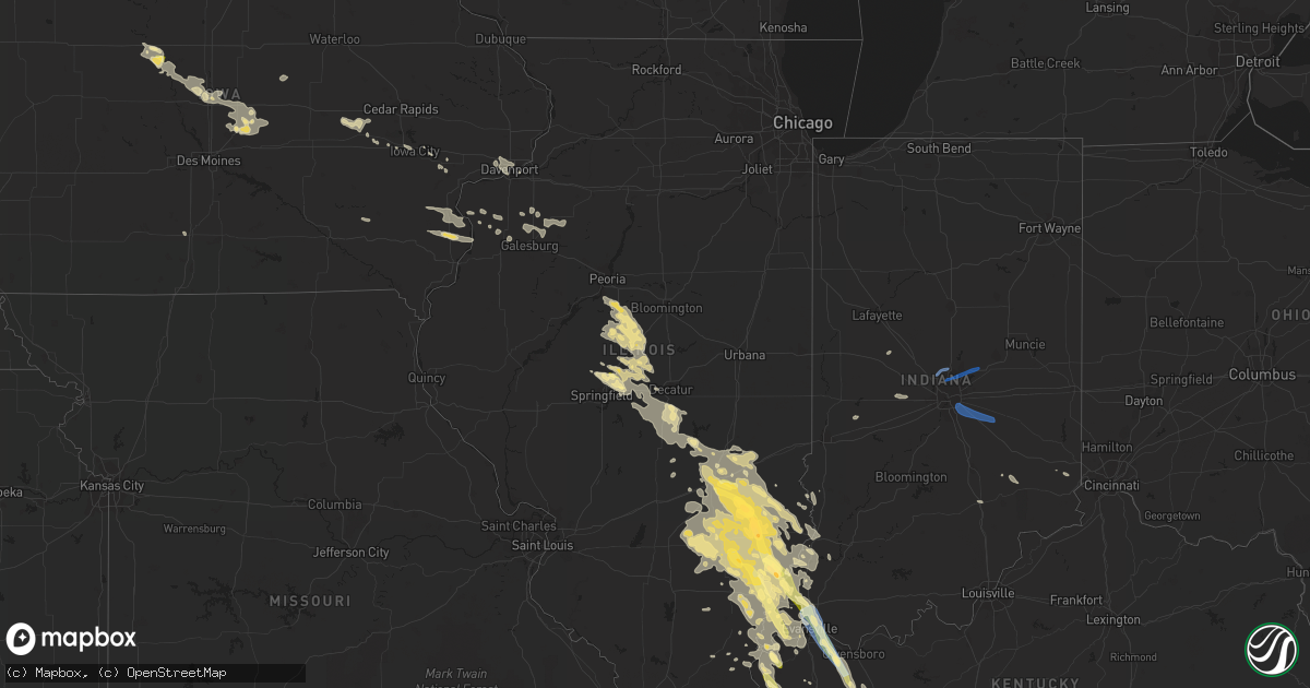
Hail Map in Illinois on August 1, 2022
Get this storm
August 1 map
$229
one time, instant access
Download today. No call, no setup
Keep the $229
Bought the map and want the full workflow? Apply the entire $229 to a subscription within 7 days. None of it is wasted.
Every map, not just this one
This buys you this map. Subscription and you get every map we run, in the markets you choose from a few cities to whole states to nationwide. Plus real-time alerts the moment a storm fires.
Contact data
Name, contact info, occupancy, even credit band for addresses in the footprint. You go from where it hit to who to call.
Become the source they trust
Unlimited branding weather history reports on demand. You already have the documented answer ready for the property owner, and you are the one who showed up with it.
Property data and RoofTrace estimates
Pull up any address you have got, its value and the exact code rules for that jurisdiction, straight from One Click Code. Then RoofTrace estimates the squares, pitch, and roof value, priced the way you price.
Storm reports in Illinois
Illinois
| Date | Description |
|---|---|
| 08/01/20226:50 PM CDT | Three foot diameter trees snapped and uprooted. |
| 08/01/20226:10 PM CDT | Reported via social media. |
| 08/01/20225:56 PM CDT | Reported on highway 15 just east of bellmont. |
| 08/01/20225:00 PM CDT | Range of sizes averaging 1.25 inch and as large as golf ball size. |
| 08/01/20224:58 PM CDT | Via social media. |
| 08/01/20224:55 PM CDT | Large tree blown down on n east st... A few yds from carle richland memorial hospital. Via social media. |
| 08/01/20224:55 PM CDT | A local report indicates 1.00 inch wind near 1 SSE OLNEY |
| 08/01/20224:40 PM CDT | Via social media. |
| 08/01/20224:40 PM CDT | A local report indicates 1.75 inch wind near BOGOTA |
| 08/01/20224:35 PM CDT | Quarter size hail report near newton power station. Time estimated by radar. |
| 08/01/20224:31 PM CDT | A local report indicates 1.50 inch wind near 3 SE BOGOTA |
| 08/01/20224:10 PM CDT | Mix of pea to quarter size hail. |
| 08/01/20223:45 PM CDT | Report relayed from broadcast media. |
| 08/01/20225:36 AM CDT | At 1036 PM CDT, a severe thunderstorm was located 7 miles west of Mount Vernon, moving southeast at 20 mph. HAZARD...60 mph wind gusts and half dollar size hail. SOURCE...Radar indicated. IMPACT...Hail damage to vehicles is expected. Expect wind damage to roofs, siding, and trees. This severe thunderstorm will be near... Mount Vernon around 1040 PM CDT.Other locations in the path of this severe thunderstorm includeUniontown, Morganfield and Breckinridge Center. |
| 08/01/20225:17 AM CDT | At 1015 PM CDT, a severe thunderstorm was located near New Harmony, or 9 miles north of Mount Vernon, moving southeast at 30 mph. HAZARD...70 mph wind gusts and half dollar size hail. SOURCE...Radar indicated. IMPACT...Hail damage to vehicles is expected. Expect considerable tree damage. Wind damage is also likely to mobile homes, roofs, and outbuildings. This severe thunderstorm will be near... Mount Vernon around 1035 PM CDT.Other locations impacted by this severe thunderstorm include Maunie. |
| 08/01/20224:56 AM CDT | At 955 PM CDT, a severe thunderstorm was located near Clay City, or 7 miles southeast of Flora, moving southeast at 25 mph. HAZARD...60 mph wind gusts and half dollar size hail. SOURCE...Radar indicated. IMPACT...Hail damage to vehicles is expected. Expect wind damage to roofs, siding, and trees. Locations impacted include... West Salem. |
| 08/01/20224:22 AM CDT | At 922 PM CDT, a severe thunderstorm was located near Uniontown, or near Morganfield, moving southeast at 20 mph. HAZARD...60 mph wind gusts and quarter size hail. SOURCE...Radar indicated. IMPACT...Hail damage to vehicles is expected. Expect wind damage to roofs, siding, and trees. This severe thunderstorm will be near... Morganfield around 940 PM CDT.Other locations in the path of this severe thunderstorm includeBreckinridge Center. |
| 08/01/20223:39 AM CDT | Report from mping: quarter |
| 08/01/20223:31 AM CDT | At 830 PM CDT, a severe thunderstorm was located over Clay City, or near Flora, moving southeast at 25 mph. HAZARD...60 mph wind gusts and half dollar size hail. SOURCE...Radar indicated. IMPACT...Hail damage to vehicles is expected. Expect wind damage to roofs, siding, and trees. Locations impacted include... Schnell. |
| 08/01/20223:10 AM CDT | Delayed report. Large tree branch |
| 08/01/20222:57 AM CDT | At 757 PM CDT, a severe thunderstorm was located near West Salem, or 12 miles northwest of Mount Carmel, moving southeast at 35 mph. HAZARD...60 mph wind gusts and half dollar size hail. SOURCE...Radar indicated. IMPACT...Hail damage to vehicles is expected. Expect wind damage to roofs, siding, and trees. Locations impacted include... Mount Carmel, Princeton and Owensville. |
| 08/01/20222:56 AM CDT | At 755 PM EDT, severe thunderstorms were located along a line extending from near St. Francisville to near Lancaster, moving southeast at 40 mph. HAZARD...60 mph wind gusts and nickel size hail. SOURCE...Radar indicated. IMPACT...Expect damage to roofs, siding, and trees. Severe thunderstorms will be near... Decker around 815 PM EDT. |
| 08/01/20221:52 AM CDT | At 651 PM CDT, a severe thunderstorm was located near Lancaster, or 11 miles southwest of Lawrenceville, moving southeast at 40 mph. HAZARD...60 mph wind gusts and half dollar size hail. SOURCE...Radar indicated. IMPACT...Hail damage to vehicles is expected. Expect wind damage to roofs, siding, and trees. This severe thunderstorm will be near... Mount Carmel around 710 PM CDT.Other locations in the path of this severe thunderstorm includePatoka. |
| 08/01/20221:32 AM CDT | At 632 PM EDT, severe thunderstorms were located along a line extending from 8 miles west of Washington to 7 miles northeast of Albion, moving southeast at 50 mph. HAZARD...60 mph wind gusts and quarter size hail. SOURCE...Radar indicated. IMPACT...Hail damage to vehicles is expected. Expect wind damage to roofs, siding, and trees. These severe thunderstorms will remain over mainly rural areas of southwestern Knox County. |
| 08/01/20221:26 AM CDT | At 626 PM CDT, a severe thunderstorm was located near Cynthiana, or 8 miles west of Fort Branch, moving southeast at 25 mph. HAZARD...60 mph wind gusts and half dollar size hail. SOURCE...Radar indicated. IMPACT...Hail damage to vehicles is expected. Expect wind damage to roofs, siding, and trees. This severe thunderstorm will be near... Fort Branch and Cynthiana around 635 PM CDT. Haubstadt around 640 PM CDT.Other locations in the path of this severe thunderstorm includeDarmstadt.This includes Interstate 64 in Indiana between Mile Markers 10 and29. |
| 08/01/20221:19 AM CDT | At 619 PM EDT, severe thunderstorms were located along a line extending from near Vincennes to near Mount Carmel, moving southeast at 65 mph. HAZARD...60 mph wind gusts and half dollar size hail. SOURCE...Radar indicated. IMPACT...Hail damage to vehicles is expected. Expect wind damage to roofs, siding, and trees. These severe thunderstorms will remain over mainly rural areas of southwestern Knox County. |
| 08/01/202212:59 AM CDT | At 558 PM CDT, a severe thunderstorm was located near Bogota, moving east-southeast at 25 mph. HAZARD...60 mph wind gusts and half dollar size hail. SOURCE...Radar indicated. IMPACT...Hail damage to vehicles is expected. Expect wind damage to roofs, siding, and trees. This severe thunderstorm will be near... Willow Hill, West Liberty and Dundas around 615 PM CDT.Other locations in the path of this severe thunderstorm include Ste.Marie, Chauncey and Hardinville. |
| 08/01/202212:53 AM CDT | At 552 PM CDT, severe thunderstorms were located along a line extending from near Patoka to near Owensville to near Grayville, moving south at 30 mph. HAZARD...60 mph wind gusts and half dollar size hail. SOURCE...Radar indicated. IMPACT...Hail damage to vehicles is expected. Expect wind damage to roofs, siding, and trees. Severe thunderstorms will be near... Princeton around 600 PM CDT. Owensville around 605 PM CDT. Oakland City around 610 PM CDT.Other locations in the path of these severe thunderstorms includeFort Branch, Poseyville, Cynthiana, Haubstadt and New Harmony.This includes the following highways... Interstate 69 in Indiana between Mile Markers 22 and 37. Interstate 64 in Indiana between Mile Markers 1 and 17. |
| 08/01/202212:15 AM CDT | At 514 PM CDT, severe thunderstorms were located along a line extending from near Lancaster to near Parkersburg, moving south at 25 mph. HAZARD...Ping pong ball size hail and 60 mph wind gusts. SOURCE...Radar indicated. IMPACT...People and animals outdoors will be injured. Expect hail damage to roofs, siding, windows, and vehicles. Expect wind damage to roofs, siding, and trees. Severe thunderstorms will be near... Lancaster and West Salem around 525 PM CDT.Other locations in the path of these severe thunderstorms includeMount Carmel, Albion and Grayville. |
| 08/01/202212:11 AM CDT | At 510 AM CDT, a severe thunderstorm was located near Lincoln, moving southeast at 50 mph. HAZARD...60 mph wind gusts. SOURCE...Radar indicated. IMPACT...Expect damage to roofs, siding, and trees. Locations impacted include... Decatur, Lincoln, Clinton, Forsyth, Maroa, Atlanta, Mount Pulaski, Harristown, Warrensburg, Argenta, Oreana, Latham, Kenney, Chestnut, Beason, Lawndale, Weldon Springs State Park, Lane, Midland City and Rowell.This includes the following highways... Interstate 55 between mile markers 132 and 139. Interstate 72 between mile markers 132 and 145. |
| 08/01/202212:01 AM CDT | At 500 AM CDT, a severe thunderstorm was located over Fountain Green, or 11 miles northeast of Carthage, moving southeast at 50 mph. HAZARD...60 mph wind gusts and quarter size hail. SOURCE...Radar indicated. IMPACT...Hail damage to vehicles is expected. Expect wind damage to roofs, siding, and trees. Locations impacted include... Macomb, Colchester, La Harpe, Blandinsville, Industry, Bardolph, Tennessee, Western Illinois University, Adair, Fandon, Colmar, Fountain Green, Pennington Point, Doddsville, Webster, Spring Lake, McDonough County 4-H Grounds and Argyle Lake State Park. |
| 07/31/202211:53 PM CDT | At 453 PM CDT, severe thunderstorms were located along a line extending from Chauncey to near Olney to near Noble, moving southeast at 25 mph. HAZARD...60 mph wind gusts and half dollar size hail. SOURCE...Radar indicated. IMPACT...Hail damage to vehicles is expected. Expect wind damage to roofs, siding, and trees. Severe thunderstorms will be near... Chauncey around 500 PM CDT. Claremont around 505 PM CDT. Sumner and Calhoun around 510 PM CDT.Other locations in the path of these severe thunderstorms includeLawrenceville, Parkersburg and St. Francisville. |
| 07/31/202211:31 PM CDT | At 430 AM CDT, a severe thunderstorm was located near Manito, or 13 miles southeast of Canton, moving southeast at 50 mph. HAZARD...60 mph wind gusts and penny size hail. SOURCE...Radar indicated. IMPACT...Expect damage to roofs, siding, and trees. Locations impacted include... Lincoln, Mason City, Delavan, Manito, South Pekin, Green Valley, San Jose, Emden, Middletown, Easton, Hartsburg, New Holland, Forest City, Topeka and Goofy Ridge.This includes the following highways... Interstate 155 between mile markers 0 and 16. Interstate 55 between mile markers 121 and 131. |
| 07/31/202211:02 PM CDT | At 401 AM CDT, a severe thunderstorm was located over London Mills, or 13 miles northwest of Canton, moving southeast at 60 mph. HAZARD...60 mph wind gusts and penny size hail. SOURCE...Radar indicated. IMPACT...Expect damage to roofs, siding, and trees. Locations impacted include... Canton, Lewistown, Farmington, Cuba, Glasford, St. David, Fairview, London Mills, Maquon, Dunfermline, Bryant, Norris, Banner, Ellisville, Little America, Fiatt and Middle Grove. |
| 07/31/202210:31 PM CDT | At 331 PM CDT, a severe thunderstorm was located near Wheeler, or 10 miles northwest of Newton, moving east at 25 mph. HAZARD...60 mph wind gusts and half dollar size hail. SOURCE...Radar indicated. IMPACT...Hail damage to vehicles is expected. Expect wind damage to roofs, siding, and trees. This severe thunderstorm will be near... Hidalgo around 350 PM CDT.Other locations in the path of this severe thunderstorm includeNewton, Ste. Marie and Willow Hill.This includes Interstate 70 between mile markers 98 and 104. |
| 07/31/202210:19 PM CDT | At 318 AM CDT, a severe thunderstorm was located near Dunlap, or 11 miles north of Peoria, moving southeast at 50 mph. HAZARD...60 mph wind gusts and penny size hail. SOURCE...Radar indicated. IMPACT...Expect damage to roofs, siding, and trees. Locations impacted include... Peoria, East Peoria, Morton, Washington, Chillicothe, Metamora, Germantown Hills, Rome, Dunlap, Washburn, Spring Bay, Bay View Gardens, Peoria Heights, Cazenovia, Hopewell, Mossville, Alta, Low Point and Lawn Ridge.This includes Interstate 74 between mile markers 88 and 90, betweenmile markers 92 and 93, and between mile markers 102 and 106. |
| 07/31/20229:54 PM CDT | At 254 AM CDT, a severe thunderstorm was located over La Fayette, or 11 miles south of Kewanee, moving southeast at 45 mph. HAZARD...60 mph wind gusts and penny size hail. SOURCE...Radar indicated. IMPACT...Expect damage to roofs, siding, and trees. Locations impacted include... Elmwood, Princeville, Wyoming, Dunlap, Toulon, Brimfield, Bradford, Williamsfield, Elmira, Victoria, West Jersey, La Fayette, Castleton, Laura, Elmore, Duncan, Snake Den Hollow, Monica and Dahinda.This includes Interstate 74 between mile markers 57 and 76. |
| 07/31/20229:44 PM CDT | At 244 AM CDT, severe thunderstorms were located along a line extending from Mineral to Galva to near North Henderson, moving east at 45 mph. HAZARD...60 mph wind gusts and penny size hail. SOURCE...Radar indicated. IMPACT...Expect damage to roofs, siding, and trees. Locations impacted include... Kewanee, Cambridge, Galva, Woodhull, Bishop Hill, Nekoma, Kewanee Municipal Airport, Ulah, German Corner and Johnson-Sauk Trail State Park. |
| 07/31/20229:34 PM CDT | At 233 AM CDT, a severe thunderstorm was located near New Windsor, or 14 miles north of Galesburg, moving southeast at 40 mph. HAZARD...60 mph wind gusts. SOURCE...Radar indicated. IMPACT...Expect damage to roofs, siding, and trees. Locations impacted include... Galesburg, Knoxville, Wataga, Oneida, Altona, Victoria, Maquon, Rio, Gilson, East Galesburg, Henderson, Snake Den Hollow and Dahinda.This includes Interstate 74 between mile markers 34 and 61. |
| 07/31/20229:12 PM CDT | At 212 AM CDT, a severe thunderstorm was located over Reynolds, or 10 miles south of Rock Island, moving southeast at 40 mph. HAZARD...60 mph wind gusts and penny size hail. SOURCE...Radar indicated. IMPACT...Expect damage to roofs, siding, and trees. Locations impacted include... Viola, Woodhull, Matherville, Alpha, Sherrard, Reynolds, Hamlet, Cable, Shale City, New Windsor, Taylor Ridge, Boden, Preemption, Ophiem, Wanlock, Swedona, Gingle Corners, Gilchrist, Old Gilchrist and Griffin. |
| 07/31/20229:08 PM CDT | At 207 AM CDT, a severe thunderstorm was located over Warner, or near East Moline, moving southeast at 35 mph. HAZARD...60 mph wind gusts and quarter size hail. SOURCE...Trained weather spotters. IMPACT...Hail damage to vehicles is expected. Expect wind damage to roofs, siding, and trees. Locations impacted include... Moline, East Moline, Cambridge, Silvis, Geneseo, Colona, Coal Valley, Orion, Atkinson, Andover, Cleveland, Lynn Center, Warner, Dayton, Carbon Cliff, Osco, Henry County Fairgrounds, Silvis Heights, Sunny Hill Estates and Sunny Hill. |
| 07/31/20228:40 PM CDT | A local report indicates 1.25 inch wind near 2 SW BONE GAP |
| 07/31/20228:30 PM CDT | A local report indicates 1.00 inch wind near 3 NE CALHOUN |
All States Impacted by Hail Map on August 1, 2022
Cities Impacted by Hail Map on August 1, 2022
- Fairfield, IL
- Madison, FL
- Rio, IL
- Oneida, IL
- Galesburg, IL
- Wataga, IL
- Dayton, IA
- Uniontown, AL
- Safford, AL
- Princeton, KY
- Ribera, NM
- Hopkinsville, KY
- Cerulean, KY
- Crofton, KY
- Gracey, KY
- Griffin, IN
- Sigel, IL
- Vincennes, IN
- Manitou, KY
- Hanson, KY
- Madisonville, KY
- Boone, IA
- Ames, IA
- Hidalgo, IL
- Greenup, IL
- Findlay, IL
- Shelbyville, IL
- Windsor, IL
- Browns, IL
- Mount Carmel, IL
- Albion, IL
- Bone Gap, IL
- Gilbert, IA
- Owensville, IN
- Nevada, IA
- Dawson Springs, KY
- Waverly, KY
- Uniontown, KY
- Morganfield, KY
- Sturgis, KY
- Stuart, NE
- Rio Rico, AZ
- Decker, IN
- Allendale, IL
- Verdigre, NE
- Niobrara, NE
- Henderson, KY
- Owensboro, KY
- Spottsville, KY
- Reed, KY
- Winter Garden, FL
- Colo, IA
- Tiffin, IA
- Oxford, IA
- Saint Charles, KY
- Athens, IL
- Merom, IN
- Palestine, IL
- Winter Haven, FL
- Lake Alfred, FL
- Haines City, FL
- Hartsburg, IL
- Green Cove Springs, FL
- Middleburg, FL
- Buffalo, IL
- Dawson, IL
- Williamsville, IL
- Sherman, IL
- Riverton, IL
- Cowden, IL
- Claysville, PA
- West Alexander, PA
- Rhodes, IA
- State Center, IA
- Moweaqua, IL
- Macon, IL
- Dalton City, IL
- Johnsonville, IL
- Flora, IL
- Iuka, IL
- Xenia, IL
- Rinard, IL
- Davenport, FL
- Polk City, FL
- Bethany, IL
- Assumption, IL
- Cantrall, IL
- Providence, KY
- Clay, KY
- Marion, KY
- Baxter, IA
- Mingo, IA
- Collins, IA
- West Salem, IL
- Burnt Prairie, IL
- Crossville, IL
- Mill Shoals, IL
- Carmi, IL
- Montrose, IL
- Edinburg, IL
- Atalissa, IA
- Rock Island, IL
- Davenport, IA
- Atkinson, NE
- Seaton, IL
- Aledo, IL
- Equality, IL
- Cadiz, KY
- Poseyville, IN
- Flat Rock, IL
- Ruston, LA
- Willow Hill, IL
- Newton, IL
- Palatka, FL
- Centreville, MS
- Liberty, MS
- Norwood, LA
- Moline, IL
- Livermore, KY
- Calhoun, KY
- Newport News, VA
- Hampton, VA
- Lincoln, IL
- Mount Pulaski, IL
- Haubstadt, IN
- Fort Branch, IN
- Cynthiana, IN
- Evansville, IN
- Bassett, NE
- Newport, NE
- Junction, IL
- Slaughters, KY
- Sebree, KY
- Punta Gorda, FL
- Bloomfield, NE
- Center, NE
- Hopedale, IL
- Atlanta, IL
- Armington, IL
- Emden, IL
- Delavan, IL
- Pekin, IL
- Tremont, IL
- Lawndale, IL
- Minier, IL
- San Jose, IL
- Beason, IL
- McLean, IL
- New Holland, IL
- Sutton, WV
- Little Birch, WV
- Lynch, NE
- Spencer, NE
- Bristow, NE
- Walcott, IA
- Osceola, IA
- Marengo, IA
- Blairstown, IA
- Belle Plaine, IA
- Luzerne, IA
- Wausa, NE
- Woodhull, IL
- Alpha, IL
- Sunman, IN
- Guilford, IN
- Laurel, IA
- Melbourne, IA
- New Harmony, IN
- Fort Dodge, IA
- Otho, IA
- Joy, IL
- Wheeler, IL
- Noble, IL
- Claremont, IL
- Ingraham, IL
- Dundas, IL
- Olney, IL
- Hilliard, FL
- Mount Vernon, IN
- Bellmont, IL
- Patoka, IN
- West Liberty, IL
- Watkins, IA
- Sullivan, IN
- Carlisle, IN
- Lynn Center, IL
- Altamont, IL
- Louisville, IL
- Grayville, IL
- Cisne, IL
- Sailor Springs, IL
- Golden Gate, IL
- Clay City, IL
- Mount Erie, IL
- Ellery, IL
- Geff, IL
- Montgomery, AL
- Beaver Dam, KY
- Windermere, FL
- Burnside, IA
- Lehigh, IA
- Inman, NE
- Morning Sun, IA
- Mediapolis, IA
- Coralville, IA
- Iowa City, IA
- Princeton, IN
- Payson, AZ
- Strasburg, IL
- Beaman, IA
- Conrad, IA
- Packwood, IA
- Richland, IA
- Fairfield, IA
- Springfield, IL
- Oneill, NE
- Avon, SD
- Wagner, SD
- Crofton, NE
- Springfield, SD
- Dante, SD
- Oakville, IA
- Burlington, IA
- Anton Chico, NM
- Sumner, IL
- Altona, IL
- Wadesville, IN
- Saint Helena, NE
- Wynot, NE
- Hammond, LA
- Ponchatoula, LA
- West Branch, IA
- New Boston, IL
- Robinson, IL
- Carbon, IN
- Brazil, IN
- Rose Hill, MS
- Yarmouth, IA
- Mount Union, IA
- Harristown, IL
- Decatur, IL
- Niantic, IL
- Orange Park, FL
- Shawneetown, IL
- Keithsburg, IL
- Toledo, IL
- Trilla, IL
- Oblong, IL
- Homestead, IA
- South Amana, IA
- Maxwell, IA
- Clermont, FL
- Kissimmee, FL
- Seymour, IN
- Hazleton, IN
- Monroe City, IN
- Petersburg, IN
- Boston, GA
- Prattville, AL
- McLeansboro, IL
- Dahlgren, IL
- Macedonia, IL
- New Haven, IL
- Ewing, NE
- Effingham, IL
- Teutopolis, IL
- Stonington, IL
- Kinmundy, IL
- Lerna, IL
- Stewardson, IL
- Mechanicsburg, IL
- Salem, IL
- Saint Elmo, IL
- Lawrenceville, IL
- Springerton, IL
- Dieterich, IL
- Calhoun, IL
- Kenney, IL
- Sainte Marie, IL
- Neoga, IL
- Tower Hill, IL
- Parkersburg, IL
- Yale, IL
- Pana, IL
- Enfield, IL
- Barnhill, IL
- Mason, IL
- Omaha, IL
- Mackinaw, IL
- Latham, IL
- Middletown, IL
- Corydon, KY
- Casey, IL
- Watson, IL
- Newburgh, IN
- Illiopolis, IL
- Warrensburg, IL
- Mason City, IL
- Taylorville, IL
- Utica, KY
- Bridgeport, IL
- Alma, IL
- Elkhart, IL
- Bluford, IL
- Fredonia, KY
- Norris City, IL
- Green Valley, IL
- Keenes, IL
- Shumway, IL
- Chestnut, IL
- Blue Mound, IL
- Island, KY
- Sims, IL
- Mount Auburn, IL
- Farina, IL
- Chandler, IN
- Edgewood, IL
- Centertown, KY
- Saint Francisville, IL
- Jewett, IL
- Mattoon, IL
- Duncombe, IA
- Lakewood, IL
- Wapello, IA
- Alexis, IL
- Little York, IL
- Stratford, IA
- Callender, IA
- Newton, IA
- Story City, IA
- Moorland, IA
- Stanhope, IA
- Galva, IL
- La Fayette, IL
- Greensburg, LA
- Eldorado, IL
- Harrisburg, IL
- Gerlaw, IL
- Magnet, NE
- Frametown, WV
- Gassaway, WV
- Ridgway, IL
- Strong, AR
- West Liberty, IA
- Westport, IN
- Butlerville, IN
- North Vernon, IN
- Vail, AZ
- Sonoita, AZ
- Hartford, KY
- Weldon, CA
- Darlington, IN
- Columbus Junction, IA
- New Windsor, IL
- Interlachen, FL
- Fordyce, NE
- Gayville, SD
- Vermillion, SD
- North Salem, IN
- Bainbridge, IN
- Danville, IN
- Clayton, LA
- Sycamore, PA
- East Millsboro, PA
- Marianna, PA
- Clarksville, PA
- Millsboro, PA
- Rices Landing, PA
- Marlette, MI
- Decker, MI
- Caro, MI
- Vassar, MI
- Mayville, MI
- Deford, MI
- Kingston, MI
- Zionsville, IN
- Westfield, IN
- Carmel, IN
- Fishers, IN
- Noblesville, IN
- Pendleton, IN
- Indianapolis, IN
- Shelbyville, IN
- Fountaintown, IN
- Fairland, IN
- Beech Grove, IN
- New Palestine, IN
- Butte, NE
- Yankton, SD
- Mission Hill, SD
- Tabor, SD
- Tyndall, SD
- North Salt Lake, UT
- Magna, UT
- Woods Cross, UT
- West Jordan, UT
- West Valley City, UT
- Salt Lake City, UT
- Bountiful, UT
- Ogden, UT
- Corinne, UT


