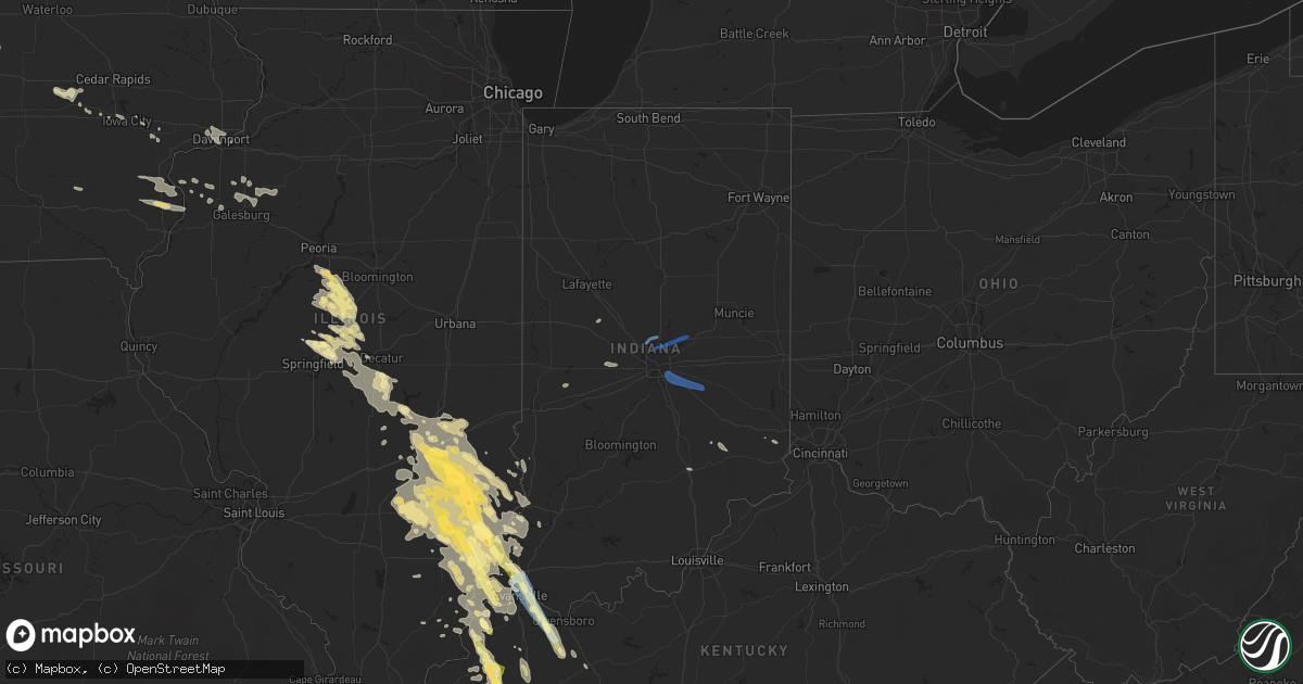
Hail Map in Indiana on August 1, 2022
Get this storm
August 1 map
$229
one time, instant access
Download today. No call, no setup
Keep the $229
Bought the map and want the full workflow? Apply the entire $229 to a subscription within 7 days. None of it is wasted.
Every map, not just this one
This buys you this map. Subscription and you get every map we run, in the markets you choose from a few cities to whole states to nationwide. Plus real-time alerts the moment a storm fires.
Contact data
Name, contact info, occupancy, even credit band for addresses in the footprint. You go from where it hit to who to call.
Become the source they trust
Unlimited branding weather history reports on demand. You already have the documented answer ready for the property owner, and you are the one who showed up with it.
Property data and RoofTrace estimates
Pull up any address you have got, its value and the exact code rules for that jurisdiction, straight from One Click Code. Then RoofTrace estimates the squares, pitch, and roof value, priced the way you price.
Storm reports in Indiana
Indiana
| Date | Description |
|---|---|
| 08/01/20226:59 PM CDT | Mping report: 1-inch tree limbs broken; shingles blown off. |
| 08/01/20226:58 PM CDT | Evansville airport asos. |
| 08/01/20226:55 PM CDT | A local report indicates 62 MPH wind near 2 S DARMSTADT |
| 08/01/20226:54 PM CDT | Tree down and took down power lines. |
| 08/01/20226:03 PM CDT | A local report indicates 1.00 inch wind near 2 SSE MOUNT CARMEL |
| 08/01/20228:27 AM CDT | Em reports trees down in the area of 200n and alexandria pike. Some trees down on houses. Time estimated via radar. |
| 08/01/20228:17 AM CDT | Trained spotter reports 60 mph estimated wind gust at london road and i-74. |
| 08/01/20228:13 AM CDT | Retired nws employee reports 70mph estimated wind gust in fishers. |
| 08/01/20228:09 AM CDT | Large tree limbs down at intersection of southport and combs. Time estimated via radar. |
| 08/01/20228:05 AM CDT | Em reports multiple trees down into power lines. |
| 08/01/20228:03 AM CDT | Large tree down at bear slide golf club in cicero. Time estimated via radar. |
| 08/01/20228:00 AM CDT | Trees reported down at the intersection of raymond street and sherman drive. Time estimated via radar. |
| 08/01/20228:00 AM CDT | Em reports that a tree is down on a house in carmel; local fire and rescue responding. |
| 08/01/20227:54 AM CDT | Law enforcement reports a downed tree is completely blocking us421 at valley meadow drive. Power is out in zionsville. |
| 08/01/20227:52 AM CDT | Five homes damaged in heatherwood estates subdivision. Multiple trees down... Some through the roofs of homes. No injuries reported. Time estimated via radar. |
| 08/01/20227:35 AM CDT | Numerous trees down on camp street near the elementary school. Powerlines affected by tree damage. Time estimated via radar. |
| 08/01/20227:35 AM CDT | Up to 900 without power due to thunderstorm wind damage. Time estimated via radar. |
| 08/01/20227:17 AM CDT | 1600 without power due to thunderstorm wind damage. Time estimated via radar. |
| 08/01/20227:03 AM CDT | Trees reported down between rosedale road and gallagher road in northern vigo county. Time estimated via radar. |
| 08/01/20226:00 AM CDT | At 1100 PM CDT, a severe thunderstorm was located near Carmi, moving southeast at 20 mph. HAZARD...Ping pong ball size hail and 60 mph wind gusts. SOURCE...Radar indicated. IMPACT...People and animals outdoors will be injured. Expect hail damage to roofs, siding, windows, and vehicles. Expect wind damage to roofs, siding, and trees. This severe thunderstorm will be near... Carmi and Crossville around 1110 PM CDT. |
| 08/01/20224:43 AM CDT | At 942 PM CDT, a severe thunderstorm was located over Morganfield, moving southeast at 20 mph. HAZARD...Ping pong ball size hail and 60 mph wind gusts. SOURCE...Radar indicated. IMPACT...People and animals outdoors will be injured. Expect hail damage to roofs, siding, windows, and vehicles. Expect wind damage to roofs, siding, and trees. This severe thunderstorm will be near... Morganfield and Breckinridge Center around 950 PM CDT.Other locations impacted by this severe thunderstorm includeWheatcroft. |
| 08/01/20224:40 AM CDT | At 939 PM CDT, a severe thunderstorm was located near Grayville, or near Albion, moving southeast at 30 mph. HAZARD...Ping pong ball size hail and 60 mph wind gusts. SOURCE...Radar indicated. IMPACT...People and animals outdoors will be injured. Expect hail damage to roofs, siding, windows, and vehicles. Expect wind damage to roofs, siding, and trees. This severe thunderstorm will be near... Grayville around 950 PM CDT. New Harmony around 1005 PM CDT. Poseyville around 1010 PM CDT. Cynthiana around 1015 PM CDT.Other locations impacted by this severe thunderstorm includePhillipstown, Griffin and Browns.This includes the following highways... Interstate 64 in Indiana between Mile Markers 1 and 16. Interstate 64 in Illinois between Mile Markers 122 and 130. |
| 08/01/20224:25 AM CDT | At 925 AM EDT, a severe thunderstorm was located over Anderson, moving east at 60 mph. HAZARD...70 mph wind gusts. SOURCE...Radar indicated. IMPACT...Expect considerable tree damage. Damage is likely to mobile homes, roofs, and outbuildings. This severe thunderstorm will be near... Daleville around 930 AM EDT. Yorktown around 935 AM EDT. Springport around 940 AM EDT. Summit Lake State Park and Prairie Creek Reservoir around 945 AM EDT.Other locations in the path of this severe thunderstorm includeMooreland and Blountsville.This includes Interstate 69 between mile markers 226 and 243. |
| 08/01/20224:14 AM CDT | At 914 AM EDT, severe thunderstorms were located along a line extending from 7 miles southwest of Anderson to 8 miles northwest of Shelbyville, moving east at 55 mph. HAZARD...70 mph wind gusts. SOURCE...Radar indicated. IMPACT...Expect considerable tree damage. Damage is likely to mobile homes, roofs, and outbuildings. Severe thunderstorms will be near... Shelbyville, Markleville and Wilkinson around 925 AM EDT. Shirley, Kennard, Cadiz, Manilla and Waldron around 930 AM EDT.Other locations in the path of these severe thunderstorms include St.Paul, Spiceland, Sulphur Springs, Mount Summit, Greensboro, Moscow,New Castle, Lewisville, Milroy, Dunreith, Sandusky, Straughn, NewSalem, Clarksburg and Lake Santee.This includes the following highways... Interstate 65 between mile markers 91 and 98. Interstate 69 between mile markers 210 and 226. Interstate 70 between mile markers 94 and 133. Interstate 74 between mile markers 99 and 131, between mile markers133 and 138, and between mile markers 143 and 144. |
| 08/01/20224:05 AM CDT | At 905 PM CDT, a severe thunderstorm was located 10 miles south of Schnell, or 10 miles northeast of Fairfield, moving southeast at 25 mph. HAZARD...60 mph wind gusts and half dollar size hail. SOURCE...Radar indicated. IMPACT...Hail damage to vehicles is expected. Expect wind damage to roofs, siding, and trees. Locations impacted include... Albion and Grayville. |
| 08/01/20223:35 AM CDT | At 834 AM EDT, a severe thunderstorm was located near Brownsburg, or 18 miles west of Indianapolis, moving east at 60 mph. HAZARD...60 mph wind gusts and nickel size hail. SOURCE...Radar indicated. IMPACT...Expect damage to roofs, siding, and trees. This severe thunderstorm will be near... Avon around 840 AM EDT. Plainfield, Speedway, Clermont, Eagle Creek Reservoir and Indianapolis Int'l Airport around 845 AM EDT. Meridian Hills, Rocky Ripple, Williams Creek, Wynnedale, Spring Hill, Crows Nest and North Crows Nest around 850 AM EDT.Other locations in the path of this severe thunderstorm include BeechGrove, Monument Circle, Indiana State Fairgrounds, Broad Ripple,Warren Park and Cumberland.This includes the following highways... Interstate 65 between mile markers 84 and 147. Interstate 69 between mile markers 200 and 211. Interstate 70 between mile markers 57 and 93. Interstate 74 between mile markers 59 and 100. |
| 08/01/20223:23 AM CDT | At 823 PM CDT, a severe thunderstorm was located near Claremont, or 7 miles southeast of Olney, moving southeast at 30 mph. HAZARD...60 mph wind gusts and half dollar size hail. SOURCE...Radar indicated. IMPACT...Hail damage to vehicles is expected. Expect wind damage to roofs, siding, and trees. This severe thunderstorm will remain over mainly rural areas of southwestern Lawrence and southeastern Richland Counties, including the following locations... Berryville, Red Hills State Park, Helena and Mount Carmel Airport. |
| 08/01/20223:12 AM CDT | At 812 AM EDT, a severe thunderstorm was located 8 miles northeast of Brazil, or 22 miles northeast of Terre Haute, moving east at 45 mph. HAZARD...60 mph wind gusts. SOURCE...Radar indicated. IMPACT...Expect damage to roofs, siding, and trees. This severe thunderstorm will be near... Reelsville around 815 AM EDT. Greencastle around 820 AM EDT. Cloverdale and Cagles Mill Lake around 825 AM EDT. Belle Union and Devore around 830 AM EDT.Other locations in the path of this severe thunderstorm includeEminence, Quincy, Little Point and Paragon.This includes the following highways... Interstate 70 between mile markers 17 and 19, and between milemarkers 29 and 56. Interstate 74 between mile markers 34 and 58. |
| 08/01/20223:01 AM CDT | At 800 PM CDT, a severe thunderstorm was located near Henderson, moving southeast at 45 mph. HAZARD...60 mph wind gusts and quarter size hail. SOURCE...Radar indicated. IMPACT...Hail damage to vehicles is expected. Expect wind damage to roofs, siding, and trees. This severe thunderstorm will be near... Henderson around 805 PM CDT.This includes the following highways... Interstate 69 in Kentucky between Mile Markers 141 and 148. Audubon Parkway between Mile Markers 1 and 13. |
| 08/01/20222:45 AM CDT | At 745 AM EDT, severe thunderstorms were located along a line extending from near Newport to 6 miles northeast of Vermilion, moving east at 50 mph. HAZARD...60 mph wind gusts. SOURCE...Radar indicated. IMPACT...Expect damage to roofs, siding, and trees. Severe thunderstorms will be near... Newport and Universal around 750 AM EDT. Clinton, Fairview Park, Montezuma, Mecca, Shepardsville and North Terre Haute around 755 AM EDT. Rosedale, Bloomingdale and Turkey Run State Park around 800 AM EDT. Rockville, Marshall and Fontanet around 805 AM EDT.Other locations in the path of these severe thunderstorms includeStaunton, Judson, Bridgeton, Brazil, Knightsville, Harmony, Carbon,Cecil Harden Lake and Lena.This includes Interstate 70 between mile markers 20 and 28. |
| 08/01/20221:46 AM CDT | At 646 PM CDT, a severe thunderstorm was located near Sumner, or 9 miles southwest of Lawrenceville, moving southeast at 35 mph. HAZARD...60 mph wind gusts and half dollar size hail. SOURCE...Radar indicated. IMPACT...Hail damage to vehicles is expected. Expect wind damage to roofs, siding, and trees. This severe thunderstorm will be near... St. Francisville around 700 PM CDT. |
| 07/31/202211:12 PM CDT | At 412 PM CDT, severe thunderstorms were located along a line extending from Willow Hill to near Bogota to 6 miles southeast of Watson, moving southeast at 25 mph. HAZARD...60 mph wind gusts and half dollar size hail. SOURCE...Radar indicated. IMPACT...Hail damage to vehicles is expected. Expect wind damage to roofs, siding, and trees. Severe thunderstorms will be near... Newton, Willow Hill and Bogota around 415 PM CDT. Ste. Marie around 420 PM CDT. Oblong around 425 PM CDT.Other locations in the path of these severe thunderstorms includeWest Liberty, Sailor Springs, Hardinville, Ingraham, New Hebron, FlatRock, Chauncey and Birds. |
| 07/31/20229:25 PM CDT | Late report. Multiple trees downed in two locations near sr3 and cr 400n. Estimated 50-60 mph winds. |
| 07/31/20227:15 PM CDT | Numerous tree limbs down. |
| 07/31/20227:08 PM CDT | Trees down near wesselman park; roof damage to nearby building. |
| 07/31/20227:08 PM CDT | Mping report; 3-inch tree limbs broken; power poles broken. |
| 07/31/20227:05 PM CDT | Tree across heidelbach ave. |
| 07/31/20227:04 PM CDT | Tree down across road on n boeke rd. |
| 07/31/20227:03 PM CDT | Large tree down and across st george road... Taking out a power line. |
| 07/31/20227:02 PM CDT | Kevv asos. |
All States Impacted by Hail Map on August 1, 2022
Cities Impacted by Hail Map on August 1, 2022
- Fairfield, IL
- Madison, FL
- Rio, IL
- Oneida, IL
- Galesburg, IL
- Wataga, IL
- Dayton, IA
- Uniontown, AL
- Safford, AL
- Princeton, KY
- Ribera, NM
- Hopkinsville, KY
- Cerulean, KY
- Crofton, KY
- Gracey, KY
- Griffin, IN
- Sigel, IL
- Vincennes, IN
- Manitou, KY
- Hanson, KY
- Madisonville, KY
- Boone, IA
- Ames, IA
- Hidalgo, IL
- Greenup, IL
- Findlay, IL
- Shelbyville, IL
- Windsor, IL
- Browns, IL
- Mount Carmel, IL
- Albion, IL
- Bone Gap, IL
- Gilbert, IA
- Owensville, IN
- Nevada, IA
- Dawson Springs, KY
- Waverly, KY
- Uniontown, KY
- Morganfield, KY
- Sturgis, KY
- Stuart, NE
- Rio Rico, AZ
- Decker, IN
- Allendale, IL
- Verdigre, NE
- Niobrara, NE
- Henderson, KY
- Owensboro, KY
- Spottsville, KY
- Reed, KY
- Winter Garden, FL
- Colo, IA
- Tiffin, IA
- Oxford, IA
- Saint Charles, KY
- Athens, IL
- Merom, IN
- Palestine, IL
- Winter Haven, FL
- Lake Alfred, FL
- Haines City, FL
- Hartsburg, IL
- Green Cove Springs, FL
- Middleburg, FL
- Buffalo, IL
- Dawson, IL
- Williamsville, IL
- Sherman, IL
- Riverton, IL
- Cowden, IL
- Claysville, PA
- West Alexander, PA
- Rhodes, IA
- State Center, IA
- Moweaqua, IL
- Macon, IL
- Dalton City, IL
- Johnsonville, IL
- Flora, IL
- Iuka, IL
- Xenia, IL
- Rinard, IL
- Davenport, FL
- Polk City, FL
- Bethany, IL
- Assumption, IL
- Cantrall, IL
- Providence, KY
- Clay, KY
- Marion, KY
- Baxter, IA
- Mingo, IA
- Collins, IA
- West Salem, IL
- Burnt Prairie, IL
- Crossville, IL
- Mill Shoals, IL
- Carmi, IL
- Montrose, IL
- Edinburg, IL
- Atalissa, IA
- Rock Island, IL
- Davenport, IA
- Atkinson, NE
- Seaton, IL
- Aledo, IL
- Equality, IL
- Cadiz, KY
- Poseyville, IN
- Flat Rock, IL
- Ruston, LA
- Willow Hill, IL
- Newton, IL
- Palatka, FL
- Centreville, MS
- Liberty, MS
- Norwood, LA
- Moline, IL
- Livermore, KY
- Calhoun, KY
- Newport News, VA
- Hampton, VA
- Lincoln, IL
- Mount Pulaski, IL
- Haubstadt, IN
- Fort Branch, IN
- Cynthiana, IN
- Evansville, IN
- Bassett, NE
- Newport, NE
- Junction, IL
- Slaughters, KY
- Sebree, KY
- Punta Gorda, FL
- Bloomfield, NE
- Center, NE
- Hopedale, IL
- Atlanta, IL
- Armington, IL
- Emden, IL
- Delavan, IL
- Pekin, IL
- Tremont, IL
- Lawndale, IL
- Minier, IL
- San Jose, IL
- Beason, IL
- McLean, IL
- New Holland, IL
- Sutton, WV
- Little Birch, WV
- Lynch, NE
- Spencer, NE
- Bristow, NE
- Walcott, IA
- Osceola, IA
- Marengo, IA
- Blairstown, IA
- Belle Plaine, IA
- Luzerne, IA
- Wausa, NE
- Woodhull, IL
- Alpha, IL
- Sunman, IN
- Guilford, IN
- Laurel, IA
- Melbourne, IA
- New Harmony, IN
- Fort Dodge, IA
- Otho, IA
- Joy, IL
- Wheeler, IL
- Noble, IL
- Claremont, IL
- Ingraham, IL
- Dundas, IL
- Olney, IL
- Hilliard, FL
- Mount Vernon, IN
- Bellmont, IL
- Patoka, IN
- West Liberty, IL
- Watkins, IA
- Sullivan, IN
- Carlisle, IN
- Lynn Center, IL
- Altamont, IL
- Louisville, IL
- Grayville, IL
- Cisne, IL
- Sailor Springs, IL
- Golden Gate, IL
- Clay City, IL
- Mount Erie, IL
- Ellery, IL
- Geff, IL
- Montgomery, AL
- Beaver Dam, KY
- Windermere, FL
- Burnside, IA
- Lehigh, IA
- Inman, NE
- Morning Sun, IA
- Mediapolis, IA
- Coralville, IA
- Iowa City, IA
- Princeton, IN
- Payson, AZ
- Strasburg, IL
- Beaman, IA
- Conrad, IA
- Packwood, IA
- Richland, IA
- Fairfield, IA
- Springfield, IL
- Oneill, NE
- Avon, SD
- Wagner, SD
- Crofton, NE
- Springfield, SD
- Dante, SD
- Oakville, IA
- Burlington, IA
- Anton Chico, NM
- Sumner, IL
- Altona, IL
- Wadesville, IN
- Saint Helena, NE
- Wynot, NE
- Hammond, LA
- Ponchatoula, LA
- West Branch, IA
- New Boston, IL
- Robinson, IL
- Carbon, IN
- Brazil, IN
- Rose Hill, MS
- Yarmouth, IA
- Mount Union, IA
- Harristown, IL
- Decatur, IL
- Niantic, IL
- Orange Park, FL
- Shawneetown, IL
- Keithsburg, IL
- Toledo, IL
- Trilla, IL
- Oblong, IL
- Homestead, IA
- South Amana, IA
- Maxwell, IA
- Clermont, FL
- Kissimmee, FL
- Seymour, IN
- Hazleton, IN
- Monroe City, IN
- Petersburg, IN
- Boston, GA
- Prattville, AL
- McLeansboro, IL
- Dahlgren, IL
- Macedonia, IL
- New Haven, IL
- Ewing, NE
- Effingham, IL
- Teutopolis, IL
- Stonington, IL
- Kinmundy, IL
- Lerna, IL
- Stewardson, IL
- Mechanicsburg, IL
- Salem, IL
- Saint Elmo, IL
- Lawrenceville, IL
- Springerton, IL
- Dieterich, IL
- Calhoun, IL
- Kenney, IL
- Sainte Marie, IL
- Neoga, IL
- Tower Hill, IL
- Parkersburg, IL
- Yale, IL
- Pana, IL
- Enfield, IL
- Barnhill, IL
- Mason, IL
- Omaha, IL
- Mackinaw, IL
- Latham, IL
- Middletown, IL
- Corydon, KY
- Casey, IL
- Watson, IL
- Newburgh, IN
- Illiopolis, IL
- Warrensburg, IL
- Mason City, IL
- Taylorville, IL
- Utica, KY
- Bridgeport, IL
- Alma, IL
- Elkhart, IL
- Bluford, IL
- Fredonia, KY
- Norris City, IL
- Green Valley, IL
- Keenes, IL
- Shumway, IL
- Chestnut, IL
- Blue Mound, IL
- Island, KY
- Sims, IL
- Mount Auburn, IL
- Farina, IL
- Chandler, IN
- Edgewood, IL
- Centertown, KY
- Saint Francisville, IL
- Jewett, IL
- Mattoon, IL
- Duncombe, IA
- Lakewood, IL
- Wapello, IA
- Alexis, IL
- Little York, IL
- Stratford, IA
- Callender, IA
- Newton, IA
- Story City, IA
- Moorland, IA
- Stanhope, IA
- Galva, IL
- La Fayette, IL
- Greensburg, LA
- Eldorado, IL
- Harrisburg, IL
- Gerlaw, IL
- Magnet, NE
- Frametown, WV
- Gassaway, WV
- Ridgway, IL
- Strong, AR
- West Liberty, IA
- Westport, IN
- Butlerville, IN
- North Vernon, IN
- Vail, AZ
- Sonoita, AZ
- Hartford, KY
- Weldon, CA
- Darlington, IN
- Columbus Junction, IA
- New Windsor, IL
- Interlachen, FL
- Fordyce, NE
- Gayville, SD
- Vermillion, SD
- North Salem, IN
- Bainbridge, IN
- Danville, IN
- Clayton, LA
- Sycamore, PA
- East Millsboro, PA
- Marianna, PA
- Clarksville, PA
- Millsboro, PA
- Rices Landing, PA
- Marlette, MI
- Decker, MI
- Caro, MI
- Vassar, MI
- Mayville, MI
- Deford, MI
- Kingston, MI
- Zionsville, IN
- Westfield, IN
- Carmel, IN
- Fishers, IN
- Noblesville, IN
- Pendleton, IN
- Indianapolis, IN
- Shelbyville, IN
- Fountaintown, IN
- Fairland, IN
- Beech Grove, IN
- New Palestine, IN
- Butte, NE
- Yankton, SD
- Mission Hill, SD
- Tabor, SD
- Tyndall, SD
- North Salt Lake, UT
- Magna, UT
- Woods Cross, UT
- West Jordan, UT
- West Valley City, UT
- Salt Lake City, UT
- Bountiful, UT
- Ogden, UT
- Corinne, UT


