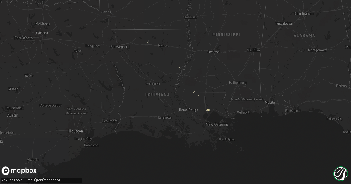
Hail Map in Louisiana on August 1, 2022
Get this storm
August 1 map
$229
one time, instant access
Download today. No call, no setup
Keep the $229
Bought the map and want the full workflow? Apply the entire $229 to a subscription within 7 days. None of it is wasted.
Every map, not just this one
This buys you this map. Subscription and you get every map we run, in the markets you choose from a few cities to whole states to nationwide. Plus real-time alerts the moment a storm fires.
Contact data
Name, contact info, occupancy, even credit band for addresses in the footprint. You go from where it hit to who to call.
Become the source they trust
Unlimited branding weather history reports on demand. You already have the documented answer ready for the property owner, and you are the one who showed up with it.
Property data and RoofTrace estimates
Pull up any address you have got, its value and the exact code rules for that jurisdiction, straight from One Click Code. Then RoofTrace estimates the squares, pitch, and roof value, priced the way you price.
Storm reports in Louisiana
Louisiana
| Date | Description |
|---|---|
| 08/01/20223:39 PM CDT | Trees reported down on interstate 12 at louisiana highway 445. |
| 08/01/20223:15 PM CDT | Central fire department shared a photo of a tree down on frenchtown rd between country and planchet rd on social media. |
| 08/01/20223:06 AM CDT | At 806 PM CDT, a severe thunderstorm was located near Farmerville, or 16 miles northeast of Ruston, and is nearly stationary. HAZARD...60 mph wind gusts and penny size hail. SOURCE...Radar indicated. IMPACT...Expect damage to roofs, siding, and trees. Locations impacted include... Farmerville, Bayou D Arbonne Lake and Shiloh. |
| 08/01/20222:38 AM CDT | At 738 PM CDT, a severe thunderstorm was located near Ruston, and is nearly stationary. HAZARD...60 mph wind gusts and nickel size hail. SOURCE...Radar indicated. IMPACT...Expect damage to roofs, siding, and trees. Locations impacted include... Ruston, Grambling, Dubach, Vienna and Unionville. |
| 07/31/202211:19 PM CDT | At 418 PM CDT, a severe thunderstorm was located over mainly rural areas of St. Helena Parish , moving northeast at 25 mph. HAZARD...60 mph wind gusts and half dollar size hail. SOURCE...Radar indicated. IMPACT...Hail damage to vehicles is expected. Expect wind damage to roofs, siding, and trees. Locations impacted include... Gillsburg, Easleyville and Darlington. |
All States Impacted by Hail Map on August 1, 2022
Cities Impacted by Hail Map on August 1, 2022
- Fairfield, IL
- Madison, FL
- Rio, IL
- Oneida, IL
- Galesburg, IL
- Wataga, IL
- Dayton, IA
- Uniontown, AL
- Safford, AL
- Princeton, KY
- Ribera, NM
- Hopkinsville, KY
- Cerulean, KY
- Crofton, KY
- Gracey, KY
- Griffin, IN
- Sigel, IL
- Vincennes, IN
- Manitou, KY
- Hanson, KY
- Madisonville, KY
- Boone, IA
- Ames, IA
- Hidalgo, IL
- Greenup, IL
- Findlay, IL
- Shelbyville, IL
- Windsor, IL
- Browns, IL
- Mount Carmel, IL
- Albion, IL
- Bone Gap, IL
- Gilbert, IA
- Owensville, IN
- Nevada, IA
- Dawson Springs, KY
- Waverly, KY
- Uniontown, KY
- Morganfield, KY
- Sturgis, KY
- Stuart, NE
- Rio Rico, AZ
- Decker, IN
- Allendale, IL
- Verdigre, NE
- Niobrara, NE
- Henderson, KY
- Owensboro, KY
- Spottsville, KY
- Reed, KY
- Winter Garden, FL
- Colo, IA
- Tiffin, IA
- Oxford, IA
- Saint Charles, KY
- Athens, IL
- Merom, IN
- Palestine, IL
- Winter Haven, FL
- Lake Alfred, FL
- Haines City, FL
- Hartsburg, IL
- Green Cove Springs, FL
- Middleburg, FL
- Buffalo, IL
- Dawson, IL
- Williamsville, IL
- Sherman, IL
- Riverton, IL
- Cowden, IL
- Claysville, PA
- West Alexander, PA
- Rhodes, IA
- State Center, IA
- Moweaqua, IL
- Macon, IL
- Dalton City, IL
- Johnsonville, IL
- Flora, IL
- Iuka, IL
- Xenia, IL
- Rinard, IL
- Davenport, FL
- Polk City, FL
- Bethany, IL
- Assumption, IL
- Cantrall, IL
- Providence, KY
- Clay, KY
- Marion, KY
- Baxter, IA
- Mingo, IA
- Collins, IA
- West Salem, IL
- Burnt Prairie, IL
- Crossville, IL
- Mill Shoals, IL
- Carmi, IL
- Montrose, IL
- Edinburg, IL
- Atalissa, IA
- Rock Island, IL
- Davenport, IA
- Atkinson, NE
- Seaton, IL
- Aledo, IL
- Equality, IL
- Cadiz, KY
- Poseyville, IN
- Flat Rock, IL
- Ruston, LA
- Willow Hill, IL
- Newton, IL
- Palatka, FL
- Centreville, MS
- Liberty, MS
- Norwood, LA
- Moline, IL
- Livermore, KY
- Calhoun, KY
- Newport News, VA
- Hampton, VA
- Lincoln, IL
- Mount Pulaski, IL
- Haubstadt, IN
- Fort Branch, IN
- Cynthiana, IN
- Evansville, IN
- Bassett, NE
- Newport, NE
- Junction, IL
- Slaughters, KY
- Sebree, KY
- Punta Gorda, FL
- Bloomfield, NE
- Center, NE
- Hopedale, IL
- Atlanta, IL
- Armington, IL
- Emden, IL
- Delavan, IL
- Pekin, IL
- Tremont, IL
- Lawndale, IL
- Minier, IL
- San Jose, IL
- Beason, IL
- McLean, IL
- New Holland, IL
- Sutton, WV
- Little Birch, WV
- Lynch, NE
- Spencer, NE
- Bristow, NE
- Walcott, IA
- Osceola, IA
- Marengo, IA
- Blairstown, IA
- Belle Plaine, IA
- Luzerne, IA
- Wausa, NE
- Woodhull, IL
- Alpha, IL
- Sunman, IN
- Guilford, IN
- Laurel, IA
- Melbourne, IA
- New Harmony, IN
- Fort Dodge, IA
- Otho, IA
- Joy, IL
- Wheeler, IL
- Noble, IL
- Claremont, IL
- Ingraham, IL
- Dundas, IL
- Olney, IL
- Hilliard, FL
- Mount Vernon, IN
- Bellmont, IL
- Patoka, IN
- West Liberty, IL
- Watkins, IA
- Sullivan, IN
- Carlisle, IN
- Lynn Center, IL
- Altamont, IL
- Louisville, IL
- Grayville, IL
- Cisne, IL
- Sailor Springs, IL
- Golden Gate, IL
- Clay City, IL
- Mount Erie, IL
- Ellery, IL
- Geff, IL
- Montgomery, AL
- Beaver Dam, KY
- Windermere, FL
- Burnside, IA
- Lehigh, IA
- Inman, NE
- Morning Sun, IA
- Mediapolis, IA
- Coralville, IA
- Iowa City, IA
- Princeton, IN
- Payson, AZ
- Strasburg, IL
- Beaman, IA
- Conrad, IA
- Packwood, IA
- Richland, IA
- Fairfield, IA
- Springfield, IL
- Oneill, NE
- Avon, SD
- Wagner, SD
- Crofton, NE
- Springfield, SD
- Dante, SD
- Oakville, IA
- Burlington, IA
- Anton Chico, NM
- Sumner, IL
- Altona, IL
- Wadesville, IN
- Saint Helena, NE
- Wynot, NE
- Hammond, LA
- Ponchatoula, LA
- West Branch, IA
- New Boston, IL
- Robinson, IL
- Carbon, IN
- Brazil, IN
- Rose Hill, MS
- Yarmouth, IA
- Mount Union, IA
- Harristown, IL
- Decatur, IL
- Niantic, IL
- Orange Park, FL
- Shawneetown, IL
- Keithsburg, IL
- Toledo, IL
- Trilla, IL
- Oblong, IL
- Homestead, IA
- South Amana, IA
- Maxwell, IA
- Clermont, FL
- Kissimmee, FL
- Seymour, IN
- Hazleton, IN
- Monroe City, IN
- Petersburg, IN
- Boston, GA
- Prattville, AL
- McLeansboro, IL
- Dahlgren, IL
- Macedonia, IL
- New Haven, IL
- Ewing, NE
- Effingham, IL
- Teutopolis, IL
- Stonington, IL
- Kinmundy, IL
- Lerna, IL
- Stewardson, IL
- Mechanicsburg, IL
- Salem, IL
- Saint Elmo, IL
- Lawrenceville, IL
- Springerton, IL
- Dieterich, IL
- Calhoun, IL
- Kenney, IL
- Sainte Marie, IL
- Neoga, IL
- Tower Hill, IL
- Parkersburg, IL
- Yale, IL
- Pana, IL
- Enfield, IL
- Barnhill, IL
- Mason, IL
- Omaha, IL
- Mackinaw, IL
- Latham, IL
- Middletown, IL
- Corydon, KY
- Casey, IL
- Watson, IL
- Newburgh, IN
- Illiopolis, IL
- Warrensburg, IL
- Mason City, IL
- Taylorville, IL
- Utica, KY
- Bridgeport, IL
- Alma, IL
- Elkhart, IL
- Bluford, IL
- Fredonia, KY
- Norris City, IL
- Green Valley, IL
- Keenes, IL
- Shumway, IL
- Chestnut, IL
- Blue Mound, IL
- Island, KY
- Sims, IL
- Mount Auburn, IL
- Farina, IL
- Chandler, IN
- Edgewood, IL
- Centertown, KY
- Saint Francisville, IL
- Jewett, IL
- Mattoon, IL
- Duncombe, IA
- Lakewood, IL
- Wapello, IA
- Alexis, IL
- Little York, IL
- Stratford, IA
- Callender, IA
- Newton, IA
- Story City, IA
- Moorland, IA
- Stanhope, IA
- Galva, IL
- La Fayette, IL
- Greensburg, LA
- Eldorado, IL
- Harrisburg, IL
- Gerlaw, IL
- Magnet, NE
- Frametown, WV
- Gassaway, WV
- Ridgway, IL
- Strong, AR
- West Liberty, IA
- Westport, IN
- Butlerville, IN
- North Vernon, IN
- Vail, AZ
- Sonoita, AZ
- Hartford, KY
- Weldon, CA
- Darlington, IN
- Columbus Junction, IA
- New Windsor, IL
- Interlachen, FL
- Fordyce, NE
- Gayville, SD
- Vermillion, SD
- North Salem, IN
- Bainbridge, IN
- Danville, IN
- Clayton, LA
- Sycamore, PA
- East Millsboro, PA
- Marianna, PA
- Clarksville, PA
- Millsboro, PA
- Rices Landing, PA
- Marlette, MI
- Decker, MI
- Caro, MI
- Vassar, MI
- Mayville, MI
- Deford, MI
- Kingston, MI
- Zionsville, IN
- Westfield, IN
- Carmel, IN
- Fishers, IN
- Noblesville, IN
- Pendleton, IN
- Indianapolis, IN
- Shelbyville, IN
- Fountaintown, IN
- Fairland, IN
- Beech Grove, IN
- New Palestine, IN
- Butte, NE
- Yankton, SD
- Mission Hill, SD
- Tabor, SD
- Tyndall, SD
- North Salt Lake, UT
- Magna, UT
- Woods Cross, UT
- West Jordan, UT
- West Valley City, UT
- Salt Lake City, UT
- Bountiful, UT
- Ogden, UT
- Corinne, UT


