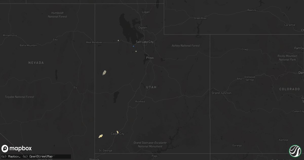
Hail Map in Utah on August 1, 2021
Get this storm
August 1 map
$229
one time, instant access
Download today. No call, no setup
Keep the $229
Bought the map and want the full workflow? Apply the entire $229 to a subscription within 7 days. None of it is wasted.
Every map, not just this one
This buys you this map. Subscription and you get every map we run, in the markets you choose from a few cities to whole states to nationwide. Plus real-time alerts the moment a storm fires.
Contact data
Name, contact info, occupancy, even credit band for addresses in the footprint. You go from where it hit to who to call.
Become the source they trust
Unlimited branding weather history reports on demand. You already have the documented answer ready for the property owner, and you are the one who showed up with it.
Property data and RoofTrace estimates
Pull up any address you have got, its value and the exact code rules for that jurisdiction, straight from One Click Code. Then RoofTrace estimates the squares, pitch, and roof value, priced the way you price.
Storm reports in Utah
Utah
| Date | Description |
|---|---|
| 08/01/20215:00 PM CDT | Photos from social media. |
| 08/01/20214:55 PM CDT | A local report indicates 63 MPH wind near 25 SSW DUGWAY |
| 08/01/20212:25 AM CDT | At 724 PM MDT, a severe thunderstorm was located near South Weber, or near Layton, moving northeast at 35 mph. HAZARD...60 mph wind gusts. SOURCE...Radar indicated. IMPACT...Expect damage to roofs, siding, and trees. Locations impacted include... Salt Lake City, Layton, Bountiful, Farmington, Hill Air Force Base, Roy, Clearfield, Kaysville, Syracuse, Clinton, North Salt Lake, Centerville, Woods Cross, Riverdale, South Weber, West Bountiful, Uintah, Salt Lake City International Airport, Magna and Emigration Canyon.This includes the following highways... Interstate 15 between mile markers 308 and 338. Interstate 84 between mile markers 85 and 86. Interstate 80 in Utah between mile markers 105 and 119. |
| 08/01/20211:47 AM CDT | At 646 PM MDT, a severe thunderstorm was located 9 miles northwest of Salt Lake City International Airport, or 13 miles northwest of West Valley City, moving northeast at 35 mph. HAZARD...60 mph wind gusts. SOURCE...Radar indicated. IMPACT...Expect damage to roofs, siding, and trees. Locations impacted include... Salt Lake City, West Valley City, Layton, Bountiful, Farmington, Hill Air Force Base, Roy, Clearfield, Kaysville, Syracuse, Clinton, North Salt Lake, Centerville, Woods Cross, Riverdale, South Weber, West Bountiful, Uintah, Salt Lake City International Airport and Magna.This includes the following highways... Interstate 15 between mile markers 307 and 338. Interstate 84 between mile markers 85 and 86. Interstate 80 in Utah between mile markers 97 and 119. |
| 08/01/20211:09 AM CDT | At 608 PM MDT, severe thunderstorms were located along a line extending from 26 miles south of Park Valley to 24 miles west of Great Salt Lake North of the Causeway to Utah Test and Training Range North, moving northeast at 25 mph. HAZARD...60 mph wind gusts and penny size hail. SOURCE...Radar indicated. IMPACT...Expect damage to roofs, siding, and trees. Locations impacted include... Utah Test and Training Range North, Great Salt Lake North of the Causeway, Gunnison Island and Lakeside. |
| 08/01/202112:30 AM CDT | At 529 PM MDT, a severe thunderstorm was located 25 miles west of Utah Test and Training Range North, or 26 miles southeast of Montello, moving east at 15 mph. HAZARD...60 mph wind gusts. SOURCE...Radar indicated. IMPACT...Expect damage to roofs, siding, and trees. This severe thunderstorm will remain over mainly rural areas of southwestern Box Elder County. |
| 07/31/202111:11 PM CDT | At 409 PM MDT, a severe thunderstorm was located 22 miles east of Fish Springs Wildlife Refuge, or 25 miles southwest of Dugway English Village, moving north at 10 mph. HAZARD...60 mph wind gusts and penny size hail. SOURCE...Radar indicated. IMPACT...Expect damage to roofs, siding, and trees. Locations impacted include... Dugway Proving Ground Test Range. |
| 07/31/20219:52 PM CDT | At 251 PM MDT, a severe thunderstorm was located 14 miles southwest of Fish Springs Wildlife Refuge, or 56 miles east of Schellbourne, moving northeast at 20 mph. HAZARD...Quarter size hail. SOURCE...Radar indicated. IMPACT...Damage to vehicles is expected. Locations impacted include... Fish Springs Wildlife Refuge. |
| 07/31/20217:50 PM CDT | A local report indicates 62 MPH wind near 4 NNE LAKE PT |
| 07/31/20217:35 PM CDT | A local report indicates 60 MPH wind near 2 W ERDA |
| 07/31/20217:30 PM CDT | Over 3000 people without power in the city of enoch. |
All States Impacted by Hail Map on August 1, 2021
Cities Impacted by Hail Map on August 1, 2021
- Orrum, NC
- Lumberton, NC
- Conway, SC
- Aynor, SC
- Catherine, AL
- Camden, AL
- McNeil, AR
- Waldo, AR
- Magnolia, AR
- Decatur, MS
- Little Rock, MS
- Ahoskie, NC
- Ramseur, NC
- Randleman, NC
- Asheboro, NC
- Bedford, TX
- Hurst, TX
- Arlington, TX
- Fort Worth, TX
- Euless, TX
- Dallas, TX
- Montezuma, GA
- Stephens, AR
- Cedar City, UT
- Climax, GA
- Bainbridge, GA
- Whigham, GA
- Moyock, NC
- Shawboro, NC
- South Mills, NC
- Elizabeth City, NC
- Camden, NC
- Sunbury, NC
- Jachin, AL
- Ward, AL
- Lisman, AL
- Mena, AR
- Edenton, NC
- Tyner, NC
- Thomaston, GA
- Thomaston, AL
- Spring Branch, TX
- Canyon Lake, TX
- Mantee, MS
- Woodland, MS
- Decatur, TX
- Weatherford, TX
- Cresson, TX
- Irving, TX
- Medford, OR
- Shiloh, GA
- Manchester, GA
- Pioneer, LA
- Sallis, MS
- Kosciusko, MS
- Langley, AR
- Edison, GA
- Morgan, GA
- Grand Prairie, TX
- Union, MS
- Marathon, TX
- Eastland, TX
- Barco, NC
- Maple, NC
- Covington, LA
- Goldthwaite, TX
- Hamilton, TX
- Moundville, AL
- Shongaloo, LA
- Emerson, AR
- Sopchoppy, FL
- Hertford, NC
- Colerain, NC
- Harrellsville, NC
- Kinston, NC
- Deep Run, NC
- Mount Olive, NC
- Seven Springs, NC
- Wrightsville, GA
- Jacksonville, OR
- Cotton Valley, LA
- Sarepta, LA
- Eldorado, TX
- Junction, TX
- Terrell, TX
- Royse City, TX
- Gold Hill, OR
- Aledo, TX
- West Point, MS
- Uvalde, TX
- Butler, AL
- Meridian, MS
- Watson, OK
- Broken Bow, OK
- Linden, AL
- Priddy, TX
- Comanche, TX
- Mullin, TX
- Wendover, UT
- Kopperl, TX
- Cleburne, TX
- Iredell, TX
- Hico, TX
- Minden, LA
- Homer, LA
- Haynesville, LA
- Meigs, GA
- Ochlocknee, GA
- Pelham, GA
- Selma, AL
- Sonora, TX
- Grannis, AR
- Rio Vista, TX
- Fountain, NC
- Glenwood, AR
- Rincon, GA
- Guyton, GA
- Wilson, NC
- Bailey, NC
- Enterprise, UT
- Cofield, NC
- Aulander, NC
- Woodland, NC
- Macclesfield, NC
- Greenville, NC
- Duck Hill, MS
- Winona, MS
- Marksville, LA
- Franklinville, NC
- Roanoke, AL
- Montgomery, AL
- Pollocksville, NC
- New Bern, NC
- Grantsboro, NC
- Arapahoe, NC
- Shiloh, NC
- Sophia, NC
- Latta, SC
- Cairo, GA
- Mason, TX
- Lewisville, AR
- Mauk, GA
- Buena Vista, GA
- Box Springs, GA
- Gustine, TX
- Clay Springs, AZ
- La Grange, NC
- Dudley, NC
- Albertson, NC
- Summit, MS
- Mccomb, MS
- Myrtle Beach, SC
- Brackettville, TX
- Beryl, UT
- Kiln, MS
- Newton Grove, NC
- Dunn, NC
- Tallahassee, FL
- Angier, NC
- Benson, NC
- Blum, TX
- Homerville, GA
- Lena, LA
- Sterlington, LA
- Pine Apple, AL
- Sulphur Springs, TX
- Vanceboro, NC
- Blounts Creek, NC
- Aurora, NC
- Edward, NC
- Sycamore, GA
- Evergreen, AL
- Stockton, UT
- Haltom City, TX
- Dublin, TX
- Minter, AL
- Ashburn, GA
- Panama City, FL
- Tooele, UT
- Laughlin, NV
- Orrville, AL
- Staley, NC
- Alberta, AL
- Leslie, GA
- Granbury, TX
- San Saba, TX
- The Colony, TX
- Carrollton, TX
- Eupora, MS
- Plano, TX
- Hobbsville, NC
- Belvidere, NC
- Rochelle, GA
- Adrian, GA
- Soperton, GA
- Rockwall, TX
- Dillon, SC
- Marion, SC
- Mullins, SC
- Pearson, GA
- Murfreesboro, AR
- Alvarado, TX
- Justin, TX
- Portland, AR
- Montrose, AR
- Centreville, MS
- Americus, GA
- Fort Stockton, TX
- Georgiana, AL
- Jena, LA
- Nemo, TX
- Woodville, MS
- Saint Francisville, LA
- Menard, TX
- Safford, AL
- Smithville, GA
- Rhome, TX
- East Dublin, GA
- Demopolis, AL
- York, AL
- Sweet Water, AL
- Andersonville, GA
- Morgan, TX
- Waycross, GA
- Cedarbluff, MS
- Louin, MS
- Bay Springs, MS
- Boerne, TX
- Pheba, MS
- Ozona, TX
- Rochelle, TX
- Brady, TX
- Rebecca, GA
- Port Gibson, MS
- Ernul, NC
- Grifton, NC
- Stonewall, MS
- Enterprise, MS
- Mansfield, TX
- Lohn, TX
- Darlington, SC
- Florence, SC
- McCool, MS
- Keene, TX
- Brinson, GA
- Richland Springs, TX
- Grantsville, UT
- Sellers, SC
- Nichols, SC
- Nakina, NC
- Clarendon, NC
- Chadbourn, NC
- Fair Bluff, NC
- Green Sea, SC
- Cerro Gordo, NC
- Whiteville, NC
- Lake View, SC
- Fairmont, NC
- Tabor City, NC
- Fork, SC
- Coinjock, NC
- Aydlett, NC
- Poplar Branch, NC
- Corolla, NC
- Grandy, NC
- Washington, NC
- Grimesland, NC
- Dover, NC
- Trenton, NC
- Rowland, NC
- Maxton, NC
- Rodanthe, NC
- Salvo, NC
- Waves, NC


