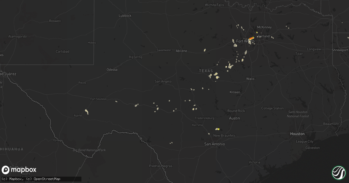
Hail Map in Texas on August 1, 2021
Get this storm
August 1 map
$229
one time, instant access
Download today. No call, no setup
Keep the $229
Bought the map and want the full workflow? Apply the entire $229 to a subscription within 7 days. None of it is wasted.
Every map, not just this one
This buys you this map. Subscription and you get every map we run, in the markets you choose from a few cities to whole states to nationwide. Plus real-time alerts the moment a storm fires.
Contact data
Name, contact info, occupancy, even credit band for addresses in the footprint. You go from where it hit to who to call.
Become the source they trust
Unlimited branding weather history reports on demand. You already have the documented answer ready for the property owner, and you are the one who showed up with it.
Property data and RoofTrace estimates
Pull up any address you have got, its value and the exact code rules for that jurisdiction, straight from One Click Code. Then RoofTrace estimates the squares, pitch, and roof value, priced the way you price.
Storm reports in Texas
Texas
| Date | Description |
|---|---|
| 08/01/20214:18 PM CDT | Emergency manager reported quarter size hail near highway 183 and brown trail. |
| 08/01/20214:15 PM CDT | Golf ball size hail was reported near forest ridge drive and highway 183. |
| 08/01/20214:14 PM CDT | Corrects previous report. Trained spotter reported trash cans blowing around in a parking lot... A chain link fence gate blown off of its hinge... And flying debris two |
| 08/01/20214:05 PM CDT | An emergency manager reported golf ball size hail near highway 183 and main street in euless. |
| 08/01/20214:05 PM CDT | Quarter size hail was reported near bedford road and highway 121. |
| 08/01/20214:03 PM CDT | An nws employee relayed a report of golf ball size hail at the faa artcc. Time estimated via radar. |
| 08/01/202112:55 AM CDT | At 555 PM CDT, a severe thunderstorm was located near New Fairview, or 12 miles northeast of Briar, moving northwest at 5 mph. HAZARD...60 mph wind gusts. SOURCE...Radar indicated. IMPACT...Expect damage to roofs, siding, and trees. Locations impacted include... Justin, Northlake and New Fairview. |
| 08/01/202112:47 AM CDT | At 547 PM CDT, a severe thunderstorm was located over Spring Branch, or 10 miles west of Canyon Lake Dam, moving south at 5 mph. HAZARD...Ping pong ball size hail. SOURCE...Radar indicated. IMPACT...People and animals outdoors will be injured. Expect damage to roofs, siding, windows, and vehicles. Locations impacted include... Canyon Lake Dam, Canyon Lake, Bulverde, Spring Branch, Smithson Valley, Fischer, Guadalupe River State Park, Timberwood Park, Anhalt, Honey Creek State Natural Area, Startzville and Specht Store. |
| 08/01/202112:02 AM CDT | At 502 PM CDT, a severe thunderstorm was located over Plano, moving southwest at 15 mph. HAZARD...60 mph wind gusts and nickel size hail. SOURCE...Radar indicated. IMPACT...Expect damage to roofs, siding, and trees. Locations impacted include... Dallas, Plano, Garland, Irving, Carrollton, Frisco, Richardson, Lewisville, Euless, Coppell, The Colony, Farmers Branch, University Park, Addison, Highland Park, Murphy, Parker, Hebron and Buckingham.This includes the following highways... Interstate 35E between mile markers 426 and 447. Interstate 30 between mile markers 43 and 49. Interstate 45 between mile markers 283 and 284. |
| 07/31/202110:50 PM CDT | At 350 PM CDT, a severe thunderstorm was located over Irving, moving west at 15 mph. HAZARD...60 mph wind gusts and penny size hail. SOURCE...Radar indicated. IMPACT...Expect damage to roofs, siding, and trees. Locations impacted include... Dallas, Fort Worth, Arlington, Irving, Grand Prairie, Carrollton, Euless, Bedford, Grapevine, Keller, Coppell, Hurst, Farmers Branch, Southlake, Colleyville, Richland Hills, North Richland Hills and Westlake.This includes the following highways... Interstate 35E between mile markers 435 and 440. Interstate 30 between mile markers 36 and 38. |
| 07/31/202110:34 PM CDT | At 334 PM CDT, a severe thunderstorm was located over Blum, or 14 miles south of Cleburne, moving north at 10 mph. HAZARD...60 mph wind gusts and quarter size hail. SOURCE...Radar indicated. IMPACT...Hail damage to vehicles is expected. Expect wind damage to roofs, siding, and trees. Locations impacted include... Cleburne, Grandview, Blum, Covington and Rio Vista. This includes Interstate 35W between mile markers 16 and 19. |
| 07/31/202110:27 PM CDT | At 327 PM CDT, a severe thunderstorm was located over Sansom Park, moving northeast at 10 mph. HAZARD...60 mph wind gusts and penny size hail. SOURCE...Radar indicated. IMPACT...Expect damage to roofs, siding, and trees. Locations impacted include... Fort Worth, Bedford, Haltom City, Keller, Hurst, Watauga, Colleyville, Benbrook, Saginaw, White Settlement, Richland Hills, River Oaks, Sansom Park, Lake Worth, Eagle Mountain, North Richland Hills, Westworth Village, Blue Mound, Haslet and Westover Hills.This includes the following highways... Interstate 35W between mile markers 48 and 64. Interstate 20 between mile markers 432 and 434. Interstate 30 between mile markers 5 and 18. |
| 07/31/202110:23 PM CDT | At 322 AM CDT, a severe thunderstorm was located over O'donnell, or 13 miles south of Tahoka, and is nearly stationary. HAZARD...60 mph wind gusts. At 315 AM, a wind gust of 62 mph was measured at the West Texas Mesonet 1 mile north of O'Donnell. SOURCE...West Texas Mesonet. IMPACT...Expect damage to roofs, siding, and trees. Locations impacted include... O'donnell. |
All States Impacted by Hail Map on August 1, 2021
Cities Impacted by Hail Map on August 1, 2021
- Orrum, NC
- Lumberton, NC
- Conway, SC
- Aynor, SC
- Catherine, AL
- Camden, AL
- McNeil, AR
- Waldo, AR
- Magnolia, AR
- Decatur, MS
- Little Rock, MS
- Ahoskie, NC
- Ramseur, NC
- Randleman, NC
- Asheboro, NC
- Bedford, TX
- Hurst, TX
- Arlington, TX
- Fort Worth, TX
- Euless, TX
- Dallas, TX
- Montezuma, GA
- Stephens, AR
- Cedar City, UT
- Climax, GA
- Bainbridge, GA
- Whigham, GA
- Moyock, NC
- Shawboro, NC
- South Mills, NC
- Elizabeth City, NC
- Camden, NC
- Sunbury, NC
- Jachin, AL
- Ward, AL
- Lisman, AL
- Mena, AR
- Edenton, NC
- Tyner, NC
- Thomaston, GA
- Thomaston, AL
- Spring Branch, TX
- Canyon Lake, TX
- Mantee, MS
- Woodland, MS
- Decatur, TX
- Weatherford, TX
- Cresson, TX
- Irving, TX
- Medford, OR
- Shiloh, GA
- Manchester, GA
- Pioneer, LA
- Sallis, MS
- Kosciusko, MS
- Langley, AR
- Edison, GA
- Morgan, GA
- Grand Prairie, TX
- Union, MS
- Marathon, TX
- Eastland, TX
- Barco, NC
- Maple, NC
- Covington, LA
- Goldthwaite, TX
- Hamilton, TX
- Moundville, AL
- Shongaloo, LA
- Emerson, AR
- Sopchoppy, FL
- Hertford, NC
- Colerain, NC
- Harrellsville, NC
- Kinston, NC
- Deep Run, NC
- Mount Olive, NC
- Seven Springs, NC
- Wrightsville, GA
- Jacksonville, OR
- Cotton Valley, LA
- Sarepta, LA
- Eldorado, TX
- Junction, TX
- Terrell, TX
- Royse City, TX
- Gold Hill, OR
- Aledo, TX
- West Point, MS
- Uvalde, TX
- Butler, AL
- Meridian, MS
- Watson, OK
- Broken Bow, OK
- Linden, AL
- Priddy, TX
- Comanche, TX
- Mullin, TX
- Wendover, UT
- Kopperl, TX
- Cleburne, TX
- Iredell, TX
- Hico, TX
- Minden, LA
- Homer, LA
- Haynesville, LA
- Meigs, GA
- Ochlocknee, GA
- Pelham, GA
- Selma, AL
- Sonora, TX
- Grannis, AR
- Rio Vista, TX
- Fountain, NC
- Glenwood, AR
- Rincon, GA
- Guyton, GA
- Wilson, NC
- Bailey, NC
- Enterprise, UT
- Cofield, NC
- Aulander, NC
- Woodland, NC
- Macclesfield, NC
- Greenville, NC
- Duck Hill, MS
- Winona, MS
- Marksville, LA
- Franklinville, NC
- Roanoke, AL
- Montgomery, AL
- Pollocksville, NC
- New Bern, NC
- Grantsboro, NC
- Arapahoe, NC
- Shiloh, NC
- Sophia, NC
- Latta, SC
- Cairo, GA
- Mason, TX
- Lewisville, AR
- Mauk, GA
- Buena Vista, GA
- Box Springs, GA
- Gustine, TX
- Clay Springs, AZ
- La Grange, NC
- Dudley, NC
- Albertson, NC
- Summit, MS
- Mccomb, MS
- Myrtle Beach, SC
- Brackettville, TX
- Beryl, UT
- Kiln, MS
- Newton Grove, NC
- Dunn, NC
- Tallahassee, FL
- Angier, NC
- Benson, NC
- Blum, TX
- Homerville, GA
- Lena, LA
- Sterlington, LA
- Pine Apple, AL
- Sulphur Springs, TX
- Vanceboro, NC
- Blounts Creek, NC
- Aurora, NC
- Edward, NC
- Sycamore, GA
- Evergreen, AL
- Stockton, UT
- Haltom City, TX
- Dublin, TX
- Minter, AL
- Ashburn, GA
- Panama City, FL
- Tooele, UT
- Laughlin, NV
- Orrville, AL
- Staley, NC
- Alberta, AL
- Leslie, GA
- Granbury, TX
- San Saba, TX
- The Colony, TX
- Carrollton, TX
- Eupora, MS
- Plano, TX
- Hobbsville, NC
- Belvidere, NC
- Rochelle, GA
- Adrian, GA
- Soperton, GA
- Rockwall, TX
- Dillon, SC
- Marion, SC
- Mullins, SC
- Pearson, GA
- Murfreesboro, AR
- Alvarado, TX
- Justin, TX
- Portland, AR
- Montrose, AR
- Centreville, MS
- Americus, GA
- Fort Stockton, TX
- Georgiana, AL
- Jena, LA
- Nemo, TX
- Woodville, MS
- Saint Francisville, LA
- Menard, TX
- Safford, AL
- Smithville, GA
- Rhome, TX
- East Dublin, GA
- Demopolis, AL
- York, AL
- Sweet Water, AL
- Andersonville, GA
- Morgan, TX
- Waycross, GA
- Cedarbluff, MS
- Louin, MS
- Bay Springs, MS
- Boerne, TX
- Pheba, MS
- Ozona, TX
- Rochelle, TX
- Brady, TX
- Rebecca, GA
- Port Gibson, MS
- Ernul, NC
- Grifton, NC
- Stonewall, MS
- Enterprise, MS
- Mansfield, TX
- Lohn, TX
- Darlington, SC
- Florence, SC
- McCool, MS
- Keene, TX
- Brinson, GA
- Richland Springs, TX
- Grantsville, UT
- Sellers, SC
- Nichols, SC
- Nakina, NC
- Clarendon, NC
- Chadbourn, NC
- Fair Bluff, NC
- Green Sea, SC
- Cerro Gordo, NC
- Whiteville, NC
- Lake View, SC
- Fairmont, NC
- Tabor City, NC
- Fork, SC
- Coinjock, NC
- Aydlett, NC
- Poplar Branch, NC
- Corolla, NC
- Grandy, NC
- Washington, NC
- Grimesland, NC
- Dover, NC
- Trenton, NC
- Rowland, NC
- Maxton, NC
- Rodanthe, NC
- Salvo, NC
- Waves, NC


