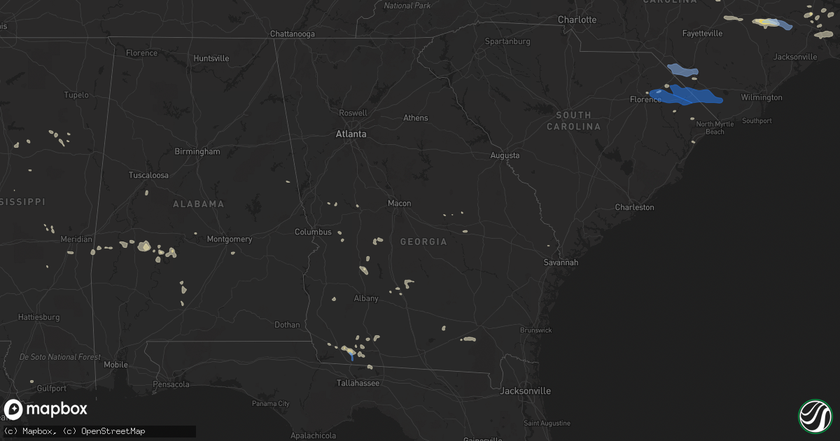
Hail Map in Georgia on August 1, 2021
Get this storm
August 1 map
$229
one time, instant access
Download today. No call, no setup
Keep the $229
Bought the map and want the full workflow? Apply the entire $229 to a subscription within 7 days. None of it is wasted.
Every map, not just this one
This buys you this map. Subscription and you get every map we run, in the markets you choose from a few cities to whole states to nationwide. Plus real-time alerts the moment a storm fires.
Contact data
Name, contact info, occupancy, even credit band for addresses in the footprint. You go from where it hit to who to call.
Become the source they trust
Unlimited branding weather history reports on demand. You already have the documented answer ready for the property owner, and you are the one who showed up with it.
Property data and RoofTrace estimates
Pull up any address you have got, its value and the exact code rules for that jurisdiction, straight from One Click Code. Then RoofTrace estimates the squares, pitch, and roof value, priced the way you price.
Storm reports in Georgia
Georgia
| Date | Description |
|---|---|
| 08/01/20216:20 PM CDT | Report of a tree downed onto wires at 4440 hwy 230 |
| 08/01/20216:03 PM CDT | A tree was reported down near the intersection of kersey rd and s hwy 41 near elko... Ga |
| 08/01/20216:03 PM CDT | A tree was reported down at hwy 329 and mims rd |
| 08/01/20216:03 PM CDT | A tree was reported down near the intersection of kersey rd and s hwy 41 near elko... Ga |
| 08/01/20215:55 PM CDT | A tree was reported down on the 500 block of toomer rd |
| 08/01/20214:30 PM CDT | Residence on hampton court in paddleford plantation had some roof shingles blown off and damage to two pear trees. |
| 08/01/20214:25 PM CDT | A tree fell through a window of a home on exley loop. On dogwood drive... A tree fell on a carport crushing a car... And another tree fell on a home. Damage was also do |
| 08/01/20214:04 PM CDT | Corrects time on previous tstm wnd dmg report from 2 sw climax. Several reports of trees and powerlines down in decatur county. |
| 08/01/20213:56 PM CDT | Several reports of trees and powerlines down in decatur county. |
| 08/01/20213:45 PM CDT | Fallen tree in cairo. |
| 08/01/20212:30 PM CDT | Trees down on highway 112 and reports of roof damage. Time estimated by radar. |
| 08/01/20214:46 AM CDT | At 946 PM EDT, severe thunderstorms were located along a line extending from 7 miles west of Cordele to 7 miles southwest of Leslie to 6 miles south of Plains, moving southeast at 20 mph. HAZARD...60 mph wind gusts and penny size hail. SOURCE...Radar indicated. IMPACT...Expect damage to roofs, siding, and trees. Locations impacted include... Leesburg, Albany, Smithville, Warwick, Starksville, Scrutchins, Chokee, Neyami, Philema, Mossy Dell, Oakfield and Stocks. |
| 08/01/20211:54 AM CDT | At 654 PM EDT, a severe thunderstorm was located near Montezuma, or near Oglethorpe, moving southeast at 25 mph. HAZARD...60 mph wind gusts and penny size hail. SOURCE...Radar indicated. IMPACT...Expect damage to roofs, siding, and trees. Locations impacted include... Unadilla, Montezuma, Byromville, Pinehurst, Dooling, Winchester and Henderson. |
| 08/01/202112:01 AM CDT | At 500 PM EDT, a severe thunderstorm was located 8 miles southeast of Bainbridge, moving southeast at 20 mph. HAZARD...60 mph wind gusts. SOURCE...Radar indicated. IMPACT...Expect damage to roofs, siding, and trees. Locations impacted include... Bainbridge, Havana, Whigham, Attapulgus, Climax, Freemont, Darsey, Florence, Concord, Jamieson, Rocky Hill, Laingkat, Calvary, Shady Rest, Reno, Fowlstown, Princes Still, Amsterdam, Branchville and Nickleville. |
All States Impacted by Hail Map on August 1, 2021
Cities Impacted by Hail Map on August 1, 2021
- Orrum, NC
- Lumberton, NC
- Conway, SC
- Aynor, SC
- Catherine, AL
- Camden, AL
- McNeil, AR
- Waldo, AR
- Magnolia, AR
- Decatur, MS
- Little Rock, MS
- Ahoskie, NC
- Ramseur, NC
- Randleman, NC
- Asheboro, NC
- Bedford, TX
- Hurst, TX
- Arlington, TX
- Fort Worth, TX
- Euless, TX
- Dallas, TX
- Montezuma, GA
- Stephens, AR
- Cedar City, UT
- Climax, GA
- Bainbridge, GA
- Whigham, GA
- Moyock, NC
- Shawboro, NC
- South Mills, NC
- Elizabeth City, NC
- Camden, NC
- Sunbury, NC
- Jachin, AL
- Ward, AL
- Lisman, AL
- Mena, AR
- Edenton, NC
- Tyner, NC
- Thomaston, GA
- Thomaston, AL
- Spring Branch, TX
- Canyon Lake, TX
- Mantee, MS
- Woodland, MS
- Decatur, TX
- Weatherford, TX
- Cresson, TX
- Irving, TX
- Medford, OR
- Shiloh, GA
- Manchester, GA
- Pioneer, LA
- Sallis, MS
- Kosciusko, MS
- Langley, AR
- Edison, GA
- Morgan, GA
- Grand Prairie, TX
- Union, MS
- Marathon, TX
- Eastland, TX
- Barco, NC
- Maple, NC
- Covington, LA
- Goldthwaite, TX
- Hamilton, TX
- Moundville, AL
- Shongaloo, LA
- Emerson, AR
- Sopchoppy, FL
- Hertford, NC
- Colerain, NC
- Harrellsville, NC
- Kinston, NC
- Deep Run, NC
- Mount Olive, NC
- Seven Springs, NC
- Wrightsville, GA
- Jacksonville, OR
- Cotton Valley, LA
- Sarepta, LA
- Eldorado, TX
- Junction, TX
- Terrell, TX
- Royse City, TX
- Gold Hill, OR
- Aledo, TX
- West Point, MS
- Uvalde, TX
- Butler, AL
- Meridian, MS
- Watson, OK
- Broken Bow, OK
- Linden, AL
- Priddy, TX
- Comanche, TX
- Mullin, TX
- Wendover, UT
- Kopperl, TX
- Cleburne, TX
- Iredell, TX
- Hico, TX
- Minden, LA
- Homer, LA
- Haynesville, LA
- Meigs, GA
- Ochlocknee, GA
- Pelham, GA
- Selma, AL
- Sonora, TX
- Grannis, AR
- Rio Vista, TX
- Fountain, NC
- Glenwood, AR
- Rincon, GA
- Guyton, GA
- Wilson, NC
- Bailey, NC
- Enterprise, UT
- Cofield, NC
- Aulander, NC
- Woodland, NC
- Macclesfield, NC
- Greenville, NC
- Duck Hill, MS
- Winona, MS
- Marksville, LA
- Franklinville, NC
- Roanoke, AL
- Montgomery, AL
- Pollocksville, NC
- New Bern, NC
- Grantsboro, NC
- Arapahoe, NC
- Shiloh, NC
- Sophia, NC
- Latta, SC
- Cairo, GA
- Mason, TX
- Lewisville, AR
- Mauk, GA
- Buena Vista, GA
- Box Springs, GA
- Gustine, TX
- Clay Springs, AZ
- La Grange, NC
- Dudley, NC
- Albertson, NC
- Summit, MS
- Mccomb, MS
- Myrtle Beach, SC
- Brackettville, TX
- Beryl, UT
- Kiln, MS
- Newton Grove, NC
- Dunn, NC
- Tallahassee, FL
- Angier, NC
- Benson, NC
- Blum, TX
- Homerville, GA
- Lena, LA
- Sterlington, LA
- Pine Apple, AL
- Sulphur Springs, TX
- Vanceboro, NC
- Blounts Creek, NC
- Aurora, NC
- Edward, NC
- Sycamore, GA
- Evergreen, AL
- Stockton, UT
- Haltom City, TX
- Dublin, TX
- Minter, AL
- Ashburn, GA
- Panama City, FL
- Tooele, UT
- Laughlin, NV
- Orrville, AL
- Staley, NC
- Alberta, AL
- Leslie, GA
- Granbury, TX
- San Saba, TX
- The Colony, TX
- Carrollton, TX
- Eupora, MS
- Plano, TX
- Hobbsville, NC
- Belvidere, NC
- Rochelle, GA
- Adrian, GA
- Soperton, GA
- Rockwall, TX
- Dillon, SC
- Marion, SC
- Mullins, SC
- Pearson, GA
- Murfreesboro, AR
- Alvarado, TX
- Justin, TX
- Portland, AR
- Montrose, AR
- Centreville, MS
- Americus, GA
- Fort Stockton, TX
- Georgiana, AL
- Jena, LA
- Nemo, TX
- Woodville, MS
- Saint Francisville, LA
- Menard, TX
- Safford, AL
- Smithville, GA
- Rhome, TX
- East Dublin, GA
- Demopolis, AL
- York, AL
- Sweet Water, AL
- Andersonville, GA
- Morgan, TX
- Waycross, GA
- Cedarbluff, MS
- Louin, MS
- Bay Springs, MS
- Boerne, TX
- Pheba, MS
- Ozona, TX
- Rochelle, TX
- Brady, TX
- Rebecca, GA
- Port Gibson, MS
- Ernul, NC
- Grifton, NC
- Stonewall, MS
- Enterprise, MS
- Mansfield, TX
- Lohn, TX
- Darlington, SC
- Florence, SC
- McCool, MS
- Keene, TX
- Brinson, GA
- Richland Springs, TX
- Grantsville, UT
- Sellers, SC
- Nichols, SC
- Nakina, NC
- Clarendon, NC
- Chadbourn, NC
- Fair Bluff, NC
- Green Sea, SC
- Cerro Gordo, NC
- Whiteville, NC
- Lake View, SC
- Fairmont, NC
- Tabor City, NC
- Fork, SC
- Coinjock, NC
- Aydlett, NC
- Poplar Branch, NC
- Corolla, NC
- Grandy, NC
- Washington, NC
- Grimesland, NC
- Dover, NC
- Trenton, NC
- Rowland, NC
- Maxton, NC
- Rodanthe, NC
- Salvo, NC
- Waves, NC


