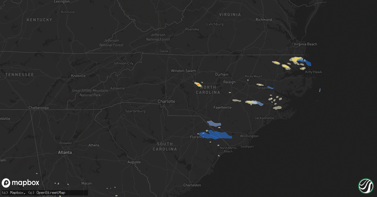
Hail Map in North Carolina on August 1, 2021
Get this storm
August 1 map
$229
one time, instant access
Download today. No call, no setup
Keep the $229
Bought the map and want the full workflow? Apply the entire $229 to a subscription within 7 days. None of it is wasted.
Every map, not just this one
This buys you this map. Subscription and you get every map we run, in the markets you choose from a few cities to whole states to nationwide. Plus real-time alerts the moment a storm fires.
Contact data
Name, contact info, occupancy, even credit band for addresses in the footprint. You go from where it hit to who to call.
Become the source they trust
Unlimited branding weather history reports on demand. You already have the documented answer ready for the property owner, and you are the one who showed up with it.
Property data and RoofTrace estimates
Pull up any address you have got, its value and the exact code rules for that jurisdiction, straight from One Click Code. Then RoofTrace estimates the squares, pitch, and roof value, priced the way you price.
Storm reports in North Carolina
North Carolina
| Date | Description |
|---|---|
| 08/01/20213:57 PM CDT | 54 knot gust reported by weatherflow mesonet station. |
| 08/01/20213:55 PM CDT | Several trees down on horris rd and shepard rd |
| 08/01/20213:25 PM CDT | Multiple trees down |
| 08/01/20212:29 PM CDT | Tree reported down on richmond road. |
| 08/01/20212:23 PM CDT | Multiple trees down blocking roadway on hwy 1 south near hamer mill road. |
| 08/01/20212:05 PM CDT | Trained spotter reported debris and construction material blown across rd. |
| 08/01/20211:52 PM CDT | Report of a full tree down roughly 2 ft. In diameter. Other 12 inch diameter branches down along road as well. |
| 08/01/20211:50 PM CDT | 911 call center reports numerous trees down with some on vehicles and houses east of asheboro and south of ramseur. Time estimated by radar. |
| 08/01/20211:46 PM CDT | Broadcast media shows picture of ping pong sized hail east of asheboro along foxfire road. Time estimated by radar. |
| 08/01/20211:45 PM CDT | Lenoir county emergency management reported trees down along john green smith rd in deep run. Time based on radar. |
| 08/01/20211:25 PM CDT | Trained spotter from fire dept reported multiple trees down on seven pines rd. |
| 08/01/20211:15 PM CDT | Reported large tree down. |
| 08/01/202112:48 PM CDT | Tree down near piney grove church road and eastfork road. Time estimated by radar. |
| 08/01/202112:41 PM CDT | Duke electric reports down tree damaging equipment near hobbton highway and maple leaf lane. Time estimated by radar. |
| 08/01/202112:41 PM CDT | Tree down near panther branch road and grimsley store road. Time estimated by radar. |
| 08/01/202112:29 PM CDT | Powerline down near the speedway on ward boulevard. Time estimated by radar. |
| 08/01/202112:25 PM CDT | Public personal weather station gusted to 68 mph. |
| 08/01/202112:23 PM CDT | Trees limbs blown down. Estimated winds 60 mph. |
| 08/01/202112:07 PM CDT | Over 50 power outages due to storm just to the north of powells point. Time estimated from radar. |
| 08/01/202111:19 AM CDT | Several trees down in corolla near a residence. Report relayed by nws binghamton... Ny. |
| 08/01/202111:15 AM CDT | Damage reported at the currituck club. |
| 08/01/202110:55 AM CDT | Corrects previous tstm wnd dmg report from 1 e taylors beach. Several large trees uprooted and large limbs snapped near shiloh. |
| 08/01/202110:55 AM CDT | Tree blocking part of waterlilly road. Time estimated. |
| 08/01/202110:35 AM CDT | Tree down on nc highway 561 east near harrellsville. Time estimated from radar. |
| 08/01/202110:00 AM CDT | Multiple power outages due to storm just north of the intersection of caratoke hwy and beechwood shores drive. Time estimated from radar data. |
| 08/01/20217:16 AM CDT | At 1215 PM EDT, severe thunderstorms were located along a line extending from near Corolla to 6 miles southwest of Grandy, moving east at 25 mph. HAZARD...60 mph wind gusts and penny size hail. SOURCE...Radar indicated. IMPACT...Expect damage to roofs, siding, and trees. Locations impacted include... Kill Devil Hills, Southern Shores, Sanderling, Duck Coe Pier, Wright Brothers National Monument and Avalon Pier. |
| 08/01/20217:11 AM CDT | At 1211 PM EDT, severe thunderstorms were located along a line extending from Chapanoke to near Hertford to near Cape Colony, moving east at 35 mph. HAZARD...60 mph wind gusts and quarter size hail. SOURCE...Radar indicated. IMPACT...Minor damage to vehicles is possible. Expect wind damage to trees and powerlines. Severe thunderstorms will be near, Chapanoke around 1215 PM EDT. Burgess, Nixonton and Snug Harbor around 1220 PM EDT. Weeksville around 1230 PM EDT.Other locations impacted by these severe thunderstorms include BobWhite Fork, Holiday Island, Rabbit Corner, Drummond Point, SymondsCreek, Listers Corner, Saint Johns, Woodville, Parkville and Hancock. |
| 08/01/20217:09 AM CDT | At 1209 PM EDT, severe thunderstorms were located along a line extending from near Corolla to near Grandy to 9 miles south of Old Trap, moving east at 35 mph. HAZARD...60 mph wind gusts and quarter size hail. SOURCE...Radar indicated. IMPACT...Minor damage to vehicles is possible. Expect wind damage to trees and powerlines. Severe thunderstorms will be near, Point Harbor around 1235 PM EDT.Other locations impacted by these severe thunderstorms include PoplarBranch, Spot, Aydlett, Listers Corner, Glen Cove, Harbinger,Jarvisburg, Frog Island, Powells Point and Texas. |
| 08/01/20216:17 AM CDT | At 1117 AM EDT, a severe thunderstorm was located near Ahoskie, moving east at 25 mph. HAZARD...60 mph wind gusts. SOURCE...Radar indicated. IMPACT...Expect damage to trees and powerlines. This severe thunderstorm will be near, Ahoskie, Winton and Cofield around 1130 AM EDT. Powellsville around 1135 AM EDT. Harrellsville around 1150 AM EDT. Colerain around 1200 PM EDT.Other locations impacted by this severe thunderstorm include GoosePond, Tunis, Earleys, Menola, Newsome Store, Arrowhead Beach, ChowanBeach, Mapleton, Trap and Mount Gould. |
| 08/01/20216:07 AM CDT | At 1107 AM EDT, severe thunderstorms were located along a line extending from near Knotts Island to near Camden to near Belvidere, moving east at 25 mph. HAZARD...60 mph wind gusts and quarter size hail. SOURCE...Radar indicated. IMPACT...Minor damage to vehicles is possible. Expect wind damage to trees and powerlines. Severe thunderstorms will be near, Knotts Island around 1115 AM EDT. Indiantown around 1120 AM EDT. Currituck and Morgans Corner around 1130 AM EDT. Elizabeth City around 1140 AM EDT. Elizabeth City State University around 1150 AM EDT. Camden and Corolla around 1155 AM EDT. Whitehall Shores and Shiloh around 1200 PM EDT.Other locations impacted by these severe thunderstorms includeBelcross, Burnt Mills, Snowden, Aydlett, Peach, Whiteston, Nicanor,Gregory, Barco and Coinjock. |
| 08/01/20212:10 AM CDT | At 710 AM EDT, a severe thunderstorm was located near Burlington, moving east at 40 mph. HAZARD...60 mph wind gusts. SOURCE...Radar indicated. IMPACT...Expect damage to roofs, siding, and trees. Locations impacted include... Durham, Chapel Hill, Burlington, Graham, Hillsborough, Carrboro, Mebane, Elon, Gibsonville and Haw River. |
| 08/01/202112:51 AM CDT | At 550 AM EDT, severe thunderstorms were located along a line extending from near Winston-Salem to near Mocksville, moving east at 25 mph. HAZARD...60 mph wind gusts and quarter size hail. SOURCE...Radar indicated. IMPACT...Hail damage to vehicles is expected. Expect wind damage to roofs, siding, and trees. Locations impacted include... Greensboro, Winston-Salem, High Point, Lexington, Thomasville, Kernersville, Clemmons, Archdale, Trinity and Jamestown. |
| 08/01/202112:14 AM CDT | At 514 AM EDT, a severe thunderstorm was located 10 miles southwest of Yadkinville, or near Harmony, moving east at 25 mph. HAZARD...60 mph wind gusts and quarter size hail. SOURCE...Radar indicated. IMPACT...Minor hail damage to vehicles is expected. Expect wind damage to trees and power lines. Locations impacted include... Mocksville, Bermuda Run, Harmony, Fork Church, Advance, Turnersburg, Sheffield, Farmington and Olin. |
| 07/31/202111:59 PM CDT | At 459 PM EDT, severe thunderstorms were located along a line extending from Evergreen to near Gapway, moving east at 55 mph. HAZARD...60 mph wind gusts. SOURCE...Radar indicated. IMPACT...Expect wind damage to trees and power lines. Locations impacted include... Whiteville, Tabor City, Loris, Chadbourn, Bethel, Lake Waccamaw, Fair Bluff, Nakina, Redbug, Bughill, Southeastern Community College, Williams, Goretown, Galivants Ferry, Cherry Grove, Old Dock, Mollie, Sidney, Clarendon and Pireway. |
| 07/31/202111:51 PM CDT | At 451 PM EDT, a severe thunderstorm was located near Bladenboro, or 11 miles northwest of Whiteville, moving east at 55 mph. HAZARD...60 mph wind gusts and penny size hail. SOURCE...Radar indicated. IMPACT...Expect wind damage to trees and power lines. Locations impacted include... Whiteville, Rowan, Bladenboro, Lake Waccamaw, Sandyfield, Carvers, Hallsboro, Abbottsburg, Lisbon, Lagoon, Elkton, Emerson, Council, Kelly, Freeman, Evergreen, Butters, Clarkton, Bolton and East Arcadia. |
| 07/31/202111:31 PM CDT | At 431 AM EDT, a severe thunderstorm was located 13 miles south of Ronda, or 4 miles northeast of Love Valley, moving east at 20 mph. HAZARD...60 mph wind gusts and penny size hail. SOURCE...Radar indicated. IMPACT...Expect damage to trees and power lines. Locations impacted include... Bermuda Run, Harmony, Love Valley, Olin, Sheffield, Union Grove and Farmington. |
| 07/31/202111:29 PM CDT | At 429 PM EDT, severe thunderstorms were located along a line extending from near Pembroke to near Blue Brick, moving east at 50 mph. HAZARD...60 mph wind gusts. SOURCE...Radar indicated. IMPACT...Expect wind damage to trees and power lines. Locations impacted include... Florence, Lumberton, Marion, Dillon, Mullins, Fairmont, Latta, Rowland, Fair Bluff, Quinby, Lake View, Sellers, Boardman, Fork, Blue Brick, Zion, Hamer, Mars Bluff, South Of The Border and Hestertown. |
| 07/31/202110:57 PM CDT | At 356 PM EDT, a severe thunderstorm was located near Minnesott Beach Ferry, or 9 miles north of Havelock, moving east at 45 mph. HAZARD...60 mph wind gusts and penny size hail. SOURCE...Radar indicated. IMPACT...Expect damage to roofs, siding, and trees. Locations impacted include... New Bern, Havelock, Cedar Island, James City, Trent Woods, River Bend, South River, Merrimon, Atlantic, Rhems, Janeiro, Great Neck, Riverdale, Whortonsville, Croatan, Nc Pamlico, Merritt, Catfish Lake, Neuse Forest and Cedar Island Ferry Terminal. |
| 07/31/202110:55 PM CDT | Several large trees uprooted and large limbs snapped near shiloh. |
| 07/31/202110:46 PM CDT | At 346 PM EDT, a severe thunderstorm was located near Rex, or 10 miles northeast of Red Springs, moving east at 25 mph. HAZARD...60 mph wind gusts. SOURCE...Radar indicated. IMPACT...Expect wind damage to trees and power lines. Locations impacted include... Rex, Shannon, Parkton, Rennert and Lumber Bridge. |
| 07/31/202110:21 PM CDT | At 320 PM EDT, severe thunderstorms were located along a line extending from near Scuppernong to near Winsteadville, moving east at 45 mph. HAZARD...60 mph wind gusts and nickel size hail. SOURCE...Radar indicated. IMPACT...Expect damage to roofs, siding, and trees. Locations impacted include... Belhaven, Killkenny, Ponzer, Swindell Fork, Scranton, Alligator, Gum Neck, Kilkenny, Fairfield, Pungo, New Holland, Columbia, East Lake, Woodley, Nebraska, Rose Bay, Wenona, Pike Road, Leechville and Lake Landing. |
| 07/31/202110:15 PM CDT | At 314 PM EDT, severe thunderstorms were located along a line extending from near Ransomville to near Phillips Crossroads, moving east at 40 mph. HAZARD...60 mph wind gusts and nickel size hail. SOURCE...Radar indicated. IMPACT...Expect damage to roofs, siding, and trees. Locations impacted include... New Bern, James City, Trent Woods, River Bend, Phillips Crossroads, Swindell Fork, Sladesville, Ransomville, Gull Rock, Blounts Creek, Pamlico Beach, Vanceboro, Askins, Lowland, Cayton, Florence, Tuscarora, Jasper, Rhems and Bonnerton. |
| 07/31/20219:42 PM CDT | At 242 PM EDT, a severe thunderstorm was located near Asheboro, moving southeast at 35 mph. HAZARD...60 mph wind gusts and quarter size hail. SOURCE...Radar indicated. IMPACT...Hail damage to vehicles is expected. Expect wind damage to roofs, siding, and trees. Locations impacted include... Asheboro, Pittsboro, Siler City, North Carolina Zoo, Goldston, Ramseur, Franklinville, Staley, Harpers Crossroads and Coleridge. |
| 07/31/20219:41 PM CDT | At 240 PM EDT, a severe thunderstorm was located near Old Ford, or near Washington, moving east at 30 mph. HAZARD...60 mph wind gusts and quarter size hail. SOURCE...Radar indicated. IMPACT...Hail damage to vehicles is expected. Expect wind damage to roofs, siding, and trees. Locations impacted include... Washington, River Road, Belhaven, Pinetown, Ransomville, Pungo, Pamlico Beach, Bunyan, Pike Road, Winsteadville, Bayview, Sidney Crossroads, Terra Ceia, Yeatesville, Old Ford, Goose Creek State Park, Bayview Ferry Terminal, Chocowinity, Long Acre VFD and Washington Park. |
| 07/31/20219:26 PM CDT | At 225 PM EDT, a severe thunderstorm was located 7 miles south of Walnut Creek, or 9 miles southwest of La Grange, moving east at 30 mph. HAZARD...60 mph wind gusts and quarter size hail. SOURCE...Radar indicated. IMPACT...Hail damage to vehicles is expected. Expect wind damage to roofs, siding, and trees. Locations impacted include... New Bern, Kinston, River Bend, Phillips Crossroads, Deep Run, Comfort, Tuscarora, Rhems, Pleasant Hill, Wyse Fork, Albertson, Dover, Sandy Bottom, Cove City, Pollocksville and Trenton. |
| 07/31/20219:15 PM CDT | At 215 PM EDT, a severe thunderstorm was located near Mount Olive, moving east at 25 mph. HAZARD...60 mph wind gusts and penny size hail. SOURCE...Radar indicated. IMPACT...Expect damage to roofs, siding, and trees. Locations impacted include... Goldsboro, Mount Olive, Walnut Creek, Seven Springs, Mar-Mac, Brogden, Cliffs Of The Neuse State Park and Elroy. |
| 07/31/20219:10 PM CDT | At 210 AM EDT, a severe thunderstorm was located near Sweetwater, moving east at 30 mph. HAZARD...60 mph wind gusts and penny size hail. SOURCE...Radar indicated. IMPACT...Expect damage to roofs, siding, and trees. Locations impacted include... Sweetwater, Loudon, Madisonville, Smoky Mountains-Twentymile Creek, Smoky Mountains-Fontana Area, Vonore, Greenback, Philadelphia, Townsend and Fort Loudon State Park.This includes Interstate 75 in Tennessee between mile markers 61 and72. |
| 07/31/20219:02 PM CDT | At 202 PM EDT, a severe thunderstorm was located over Bruce, or near Farmville, moving east at 25 mph. HAZARD...60 mph wind gusts and quarter size hail. SOURCE...Radar indicated. IMPACT...Hail damage to vehicles is expected. Expect wind damage to roofs, siding, and trees. Locations impacted include... Greenville, Washington, Farmville, River Road, Stokes, Bell Arthur, Pinetown, Pactolus, House, Black Jack, Bruce, Bayview, Bunyan, Core Point, Terra Ceia, Yeatesville, Old Ford, Pitt Greenville Airport, Dowdy Ficklen Stadium and Goose Creek State Park. |
| 07/31/20219:00 PM CDT | At 200 PM EDT, severe thunderstorms were located along a line extending from 6 miles northwest of Bruce to near Fremont to near Benson, moving southeast at 25 mph. HAZARD...60 mph wind gusts and penny size hail. SOURCE...Radar indicated. IMPACT...Expect damage to roofs, siding, and trees. Locations impacted include... Goldsboro, Smithfield, Fremont, Micro, Selma, Four Oaks, Pine Level, Kenly, Princeton and Stantonsburg. |
| 07/31/20218:31 PM CDT | At 130 PM EDT, a severe thunderstorm was located 12 miles southeast of Benson, or 17 miles south of Smithfield, moving east at 25 mph. HAZARD...60 mph wind gusts and quarter size hail. SOURCE...Radar indicated. IMPACT...Hail damage to vehicles is expected. Expect wind damage to roofs, siding, and trees. Locations impacted include... Goldsboro, Mount Olive, Walnut Creek, Newton Grove, Seven Springs, Hobbton, Mar-Mac, Brogden, Cliffs Of The Neuse State Park and Elroy. |
| 07/31/20218:22 PM CDT | At 121 PM EDT, severe thunderstorms were located along a line extending from Elm City to near Angier, moving east at 30 mph. HAZARD...60 mph wind gusts and penny size hail. SOURCE...Radar indicated. IMPACT...Expect damage to roofs, siding, and trees. Locations impacted include... Rocky Mount, Tarboro, Smithfield, Wilson, Fuquay-Varina, Clayton, Elm City, Fremont, Bailey and Micro. |
| 07/31/20218:05 PM CDT | At 104 PM EDT, a severe thunderstorm was located over Point Harbor, or 9 miles south of Grandy, moving east at 35 mph. HAZARD...60 mph wind gusts. SOURCE...Radar indicated. IMPACT...Expect damage to trees and powerlines. This severe thunderstorm will remain over mainly rural areas of southeastern Currituck County, including the following locations... Harbinger, Powells Point, Spot and Mamie. |
| 07/31/20218:03 PM CDT | At 103 PM EDT, severe thunderstorms were located along a line extending from Point Harbor to near Mashoes to near East Lake, moving east at 40 mph. HAZARD...60 mph wind gusts. SOURCE...Radar indicated. IMPACT...Expect damage to roofs, siding, and trees. Locations impacted include... Kill Devil Hills, Southern Shores, Manns Harbor, Nags Head, Mashoes, Manteo, Colington, Whalebone, Duck Coe Pier, Jockeys Ridge State Park, Roanoke Island Festival Park, Wright Brothers National Monument, Nags Head Fishing Pier, Avalon Pier, Wanchese, Bodie Island Lighthouse and Outer Banks Fishing Pier. |
All States Impacted by Hail Map on August 1, 2021
Cities Impacted by Hail Map on August 1, 2021
- Orrum, NC
- Lumberton, NC
- Conway, SC
- Aynor, SC
- Catherine, AL
- Camden, AL
- McNeil, AR
- Waldo, AR
- Magnolia, AR
- Decatur, MS
- Little Rock, MS
- Ahoskie, NC
- Ramseur, NC
- Randleman, NC
- Asheboro, NC
- Bedford, TX
- Hurst, TX
- Arlington, TX
- Fort Worth, TX
- Euless, TX
- Dallas, TX
- Montezuma, GA
- Stephens, AR
- Cedar City, UT
- Climax, GA
- Bainbridge, GA
- Whigham, GA
- Moyock, NC
- Shawboro, NC
- South Mills, NC
- Elizabeth City, NC
- Camden, NC
- Sunbury, NC
- Jachin, AL
- Ward, AL
- Lisman, AL
- Mena, AR
- Edenton, NC
- Tyner, NC
- Thomaston, GA
- Thomaston, AL
- Spring Branch, TX
- Canyon Lake, TX
- Mantee, MS
- Woodland, MS
- Decatur, TX
- Weatherford, TX
- Cresson, TX
- Irving, TX
- Medford, OR
- Shiloh, GA
- Manchester, GA
- Pioneer, LA
- Sallis, MS
- Kosciusko, MS
- Langley, AR
- Edison, GA
- Morgan, GA
- Grand Prairie, TX
- Union, MS
- Marathon, TX
- Eastland, TX
- Barco, NC
- Maple, NC
- Covington, LA
- Goldthwaite, TX
- Hamilton, TX
- Moundville, AL
- Shongaloo, LA
- Emerson, AR
- Sopchoppy, FL
- Hertford, NC
- Colerain, NC
- Harrellsville, NC
- Kinston, NC
- Deep Run, NC
- Mount Olive, NC
- Seven Springs, NC
- Wrightsville, GA
- Jacksonville, OR
- Cotton Valley, LA
- Sarepta, LA
- Eldorado, TX
- Junction, TX
- Terrell, TX
- Royse City, TX
- Gold Hill, OR
- Aledo, TX
- West Point, MS
- Uvalde, TX
- Butler, AL
- Meridian, MS
- Watson, OK
- Broken Bow, OK
- Linden, AL
- Priddy, TX
- Comanche, TX
- Mullin, TX
- Wendover, UT
- Kopperl, TX
- Cleburne, TX
- Iredell, TX
- Hico, TX
- Minden, LA
- Homer, LA
- Haynesville, LA
- Meigs, GA
- Ochlocknee, GA
- Pelham, GA
- Selma, AL
- Sonora, TX
- Grannis, AR
- Rio Vista, TX
- Fountain, NC
- Glenwood, AR
- Rincon, GA
- Guyton, GA
- Wilson, NC
- Bailey, NC
- Enterprise, UT
- Cofield, NC
- Aulander, NC
- Woodland, NC
- Macclesfield, NC
- Greenville, NC
- Duck Hill, MS
- Winona, MS
- Marksville, LA
- Franklinville, NC
- Roanoke, AL
- Montgomery, AL
- Pollocksville, NC
- New Bern, NC
- Grantsboro, NC
- Arapahoe, NC
- Shiloh, NC
- Sophia, NC
- Latta, SC
- Cairo, GA
- Mason, TX
- Lewisville, AR
- Mauk, GA
- Buena Vista, GA
- Box Springs, GA
- Gustine, TX
- Clay Springs, AZ
- La Grange, NC
- Dudley, NC
- Albertson, NC
- Summit, MS
- Mccomb, MS
- Myrtle Beach, SC
- Brackettville, TX
- Beryl, UT
- Kiln, MS
- Newton Grove, NC
- Dunn, NC
- Tallahassee, FL
- Angier, NC
- Benson, NC
- Blum, TX
- Homerville, GA
- Lena, LA
- Sterlington, LA
- Pine Apple, AL
- Sulphur Springs, TX
- Vanceboro, NC
- Blounts Creek, NC
- Aurora, NC
- Edward, NC
- Sycamore, GA
- Evergreen, AL
- Stockton, UT
- Haltom City, TX
- Dublin, TX
- Minter, AL
- Ashburn, GA
- Panama City, FL
- Tooele, UT
- Laughlin, NV
- Orrville, AL
- Staley, NC
- Alberta, AL
- Leslie, GA
- Granbury, TX
- San Saba, TX
- The Colony, TX
- Carrollton, TX
- Eupora, MS
- Plano, TX
- Hobbsville, NC
- Belvidere, NC
- Rochelle, GA
- Adrian, GA
- Soperton, GA
- Rockwall, TX
- Dillon, SC
- Marion, SC
- Mullins, SC
- Pearson, GA
- Murfreesboro, AR
- Alvarado, TX
- Justin, TX
- Portland, AR
- Montrose, AR
- Centreville, MS
- Americus, GA
- Fort Stockton, TX
- Georgiana, AL
- Jena, LA
- Nemo, TX
- Woodville, MS
- Saint Francisville, LA
- Menard, TX
- Safford, AL
- Smithville, GA
- Rhome, TX
- East Dublin, GA
- Demopolis, AL
- York, AL
- Sweet Water, AL
- Andersonville, GA
- Morgan, TX
- Waycross, GA
- Cedarbluff, MS
- Louin, MS
- Bay Springs, MS
- Boerne, TX
- Pheba, MS
- Ozona, TX
- Rochelle, TX
- Brady, TX
- Rebecca, GA
- Port Gibson, MS
- Ernul, NC
- Grifton, NC
- Stonewall, MS
- Enterprise, MS
- Mansfield, TX
- Lohn, TX
- Darlington, SC
- Florence, SC
- McCool, MS
- Keene, TX
- Brinson, GA
- Richland Springs, TX
- Grantsville, UT
- Sellers, SC
- Nichols, SC
- Nakina, NC
- Clarendon, NC
- Chadbourn, NC
- Fair Bluff, NC
- Green Sea, SC
- Cerro Gordo, NC
- Whiteville, NC
- Lake View, SC
- Fairmont, NC
- Tabor City, NC
- Fork, SC
- Coinjock, NC
- Aydlett, NC
- Poplar Branch, NC
- Corolla, NC
- Grandy, NC
- Washington, NC
- Grimesland, NC
- Dover, NC
- Trenton, NC
- Rowland, NC
- Maxton, NC
- Rodanthe, NC
- Salvo, NC
- Waves, NC


