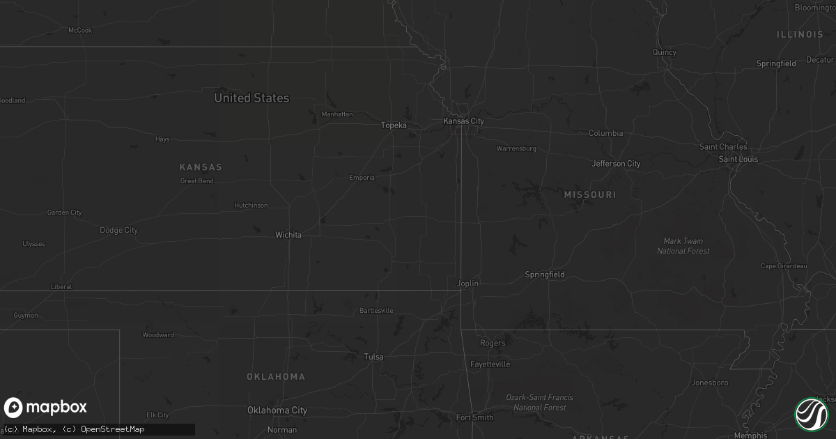
Hail Map in North Carolina on July 28, 2013
Get this storm
July 28 map
$229
one time, instant access
Download today. No call, no setup
Keep the $229
Bought the map and want the full workflow? Apply the entire $229 to a subscription within 7 days. None of it is wasted.
Every map, not just this one
This buys you this map. Subscription and you get every map we run, in the markets you choose from a few cities to whole states to nationwide. Plus real-time alerts the moment a storm fires.
Contact data
Name, contact info, occupancy, even credit band for addresses in the footprint. You go from where it hit to who to call.
Become the source they trust
Unlimited branding weather history reports on demand. You already have the documented answer ready for the property owner, and you are the one who showed up with it.
Property data and RoofTrace estimates
Pull up any address you have got, its value and the exact code rules for that jurisdiction, straight from One Click Code. Then RoofTrace estimates the squares, pitch, and roof value, priced the way you price.
Storm reports in North Carolina
North Carolina
| Date | Description |
|---|---|
| 07/28/20134:30 PM CDT | Numerous trees down with power outage. Trees and tree limbs litter about a 1 mile stretch of hamptonville road. Dime size hail covered the ground and damaged crops. Lea |
| 07/28/20133:25 PM CDT | Public report of at least 2 trees down on rollins road. Rained so hard the person was not sure if hail was in the storm. |
| 07/27/201310:05 PM CDT | Trees and powerlines down at the intersection of pagetown road and altamahaw union ridge road. Time estimated by radar. |
| 07/27/20139:50 PM CDT | Tree down near the intersection of hinshaw town rd and nc42 |
| 07/27/20139:45 PM CDT | Tree down near the intersection of iron mountain rd and nc42. |
| 07/27/20139:37 PM CDT | One tree down across tot hill farm road. |
| 07/27/20139:30 PM CDT | Tree blown down onto a house...trapping resident inside. No injuries. |
| 07/27/20139:10 PM CDT | Tree down on checkmark road near charles mountain road. |
All States Impacted by Hail Map on July 28, 2013
Cities Impacted by Hail Map on July 28, 2013
- Duchesne, UT
- Chinook, MT
- Newcastle, WY
- Dolan Springs, AZ
- Shelby, MT
- Malta, ID
- Terreton, ID
- Hamer, ID
- Lodge Grass, MT
- Billings, MT
- Lewistown, MT
- Denton, MT
- Colora, MD
- Rising Sun, MD
- Oxford, PA
- North East, MD
- Elkton, MD
- Nottingham, PA
- Amargosa Valley, NV
- Boulder, MT
- Jefferson City, MT
- Orlando, FL
- Casper, WY
- Death Valley, CA
- Lance Creek, WY
- Las Vegas, NV
- Amherst, VA
- Arrington, VA
- Panaca, NV
- Arimo, ID
- Mccammon, ID
- Hays, MT
- Okeechobee, FL
- Box Elder, MT
- North Wilkesboro, NC
- Union Grove, NC
- Kremlin, MT
- Malta, MT
- Winter Park, FL
- Jordan, MT
- Williams, AZ
- Supai, AZ
- Wilmington, DE
- Newark, DE
- Alamo, NV
- Kingman, AZ
- Grouse Creek, UT
- Elmer, NJ
- Wilsall, MT
- Weston, WY
- Ledger, MT
- Bridgeton, NJ
- Summit Hill, PA
- Nesquehoning, PA
- Socorro, NM
- Trenton, FL
- Joplin, MT
- Loring, MT
- Newton, NJ
- Columbia, NJ
- Havre, MT
- Howe, ID
- Moore Haven, FL
- Bellevue, ID
- Sedley, VA
- Courtland, VA
- Ivor, VA
- Wakefield, VA
- Yucca, AZ
- Belt, MT
- Geyser, MT
- Nipton, CA
- New Castle, DE
- Maitland, FL
- Dodson, MT
- Lloyd, MT
- Blackstone, VA
- Hamptonville, NC
- Clifton, ID
- Rawlings, VA
- Alberta, VA
- Hertford, NC
- Palm Coast, FL
- Vernon, UT
- Davenport, FL
- Landenberg, PA
- Hockessin, DE
- Beryl, UT
- Raynesford, MT
- Hurricane, UT
- Pahrump, NV
- Winter Springs, FL
- Oviedo, FL
- Egg Harbor City, NJ
- Peach Springs, AZ
- Chester, MT
- Mims, FL
- Gildford, MT
- Port Orange, FL
- Chatsworth, NJ
- Leesburg, FL
- Okahumpka, FL
- Century, FL
- Belgrade, MT
- Kaycee, WY
- Brooksville, FL
- Three Forks, MT
- Fruitland Park, FL
- New Smyrna Beach, FL
- Hilger, MT
- Ocala, FL
- Dunnellon, FL
- Groveland, FL
- Farnham, VA
- Geneva, FL
- Preston, ID
- Newport, NJ


