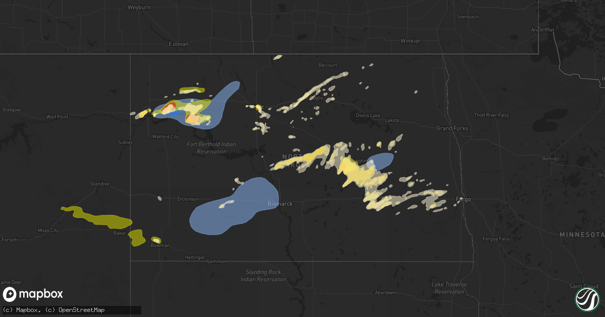
Hail Map in North Dakota on July 25, 2025
Get this storm
July 25 map
$229
one time, instant access
Download today. No call, no setup
Keep the $229
Bought the map and want the full workflow? Apply the entire $229 to a subscription within 7 days. None of it is wasted.
Every map, not just this one
This buys you this map. Subscription and you get every map we run, in the markets you choose from a few cities to whole states to nationwide. Plus real-time alerts the moment a storm fires.
Contact data
Name, contact info, occupancy, even credit band for addresses in the footprint. You go from where it hit to who to call.
Become the source they trust
Unlimited branding weather history reports on demand. You already have the documented answer ready for the property owner, and you are the one who showed up with it.
Property data and RoofTrace estimates
Pull up any address you have got, its value and the exact code rules for that jurisdiction, straight from One Click Code. Then RoofTrace estimates the squares, pitch, and roof value, priced the way you price.
Storm reports in North Dakota
North Dakota
| Date | Description |
|---|---|
| 07/25/20256:44 PM CDT | Quarter to ping pong ball size hail. |
| 07/25/20252:25 AM CDT | Glenfield nddot mesonet. Radar estimated time. |
| 07/25/20252:15 AM CDT | Public relayed report of wind gusts of 60 to 65 mph. Also had dime sized hail and 1.6 inches of rainfall. |
| 07/25/20252:15 AM CDT | Public relayed report of wind gusts of 60 to 65 mph. Also had dime sized hail and 1.6 inch |
| 07/25/20251:45 AM CDT | Photo relayed from social media of multiple tree branches down at the golf course in carrington. Time estimated from radar. |
| 07/25/20251:45 AM CDT | Report of a couple of uprooted trees and a fence blown over at a park in carrington. Public report relayed to the nws by broadcast meteorologist. |
| 07/25/20251:18 AM CDT | Measured wind gust from private weather station. |
| 07/25/20251:02 AM CDT | Report from mping: ping pong ball |
| 07/25/202512:08 AM CDT | Relayed through social media. Estimated wind speed with pea sized hail and 2.5 inches of rain over about 2 hours. Time estimated from radar. |
| 07/24/202510:30 PM CDT | Ndawn station lefor 10se. Reported at 10 meters... 40 mph at the surface. |
| 07/24/20258:15 PM CDT | Ndawn stanley 8sw. Recorded at 10 meters... 52 mph at the surface. |
| 07/24/20258:15 PM CDT | Time estimated from radar. |
| 07/24/20258:05 PM CDT | Mesonet station 327400 10 sw ross |
| 07/24/20257:39 PM CDT | Ndawn dry fork 1se. Recorded at 10 meters... Peak 63 mph at the surface. |
| 07/24/20257:28 PM CDT | Ndawn hofflund. Reported from 10 meters... 68 mph at the surface. |
| 07/24/20257:11 PM CDT | A local report indicates 1.00 inch wind near Williston |
All States Impacted by Hail Map on July 25, 2025
Cities Impacted by Hail Map on July 25, 2025
- South Lee, MA
- Stockbridge, MA
- Great Barrington, MA
- Monterey, MA
- Tyringham, MA
- Lee, MA
- Otis, MA
- Moundsville, WV
- Powhatan Point, OH
- Proctor, WV
- Clarington, OH
- Woodbury, CT
- Middlebury, CT
- Watertown, CT
- Waterbury, CT
- Glen Easton, WV
- Bethlehem, CT
- Washington, CT
- Wind Ridge, PA
- Aleppo, PA
- Cameron, WV
- Pine Plains, NY
- Coburn, PA
- Aaronsburg, PA
- Woodward, PA
- Ancramdale, NY
- Millerton, NY
- Ancram, NY
- Millmont, PA
- Milroy, PA
- Cheshire, CT
- Hamden, CT
- Prospect, CT
- Chepachet, RI
- Wallingford, CT
- North Haven, CT
- Lincoln, RI
- Cumberland, RI
- Providence, RI
- Smithfield, RI
- Bethany, CT
- Dornsife, PA
- Parsippany, NJ
- Mountain Lakes, NJ
- Mount Tabor, NJ
- Morristown, NJ
- Cedar Knolls, NJ
- Whippany, NJ
- Montville, NJ
- Lake Hiawatha, NJ
- Boonton, NJ
- Morris Plains, NJ
- Denville, NJ
- Florham Park, NJ
- Madison, NJ
- East Hanover, NJ
- Chatham, NJ
- Green Village, NJ
- Summit, NJ
- Short Hills, NJ
- Livingston, NJ
- Pine Brook, NJ
- Fairfield, NJ
- Roseland, NJ
- West Orange, NJ
- Essex Fells, NJ
- Caldwell, NJ
- Delaplane, VA
- Markham, VA
- Millburn, NJ
- Springfield, NJ
- Newark, NJ
- Union, NJ
- Vauxhall, NJ
- Maplewood, NJ
- South Orange, NJ
- Irvington, NJ
- Kenilworth, NJ
- Roselle Park, NJ
- Elizabeth, NJ
- Roselle, NJ
- Hillside, NJ
- Cranford, NJ
- Linden, NJ
- Carteret, NJ
- Rahway, NJ
- Avenel, NJ
- Port Reading, NJ
- Murrysville, PA
- Pittsburgh, PA
- New Kensington, PA
- Hagerstown, IN
- Cambridge City, IN
- North Scituate, RI
- Johnston, RI
- Cranston, RI
- Jackson Center, OH
- Huntsville, OH
- Lakeview, OH
- Sewaren, NJ
- Russells Point, OH
- Apollo, PA
- Elizabethport, NJ
- Staten Island, NY
- Bayonne, NJ
- Arcanum, OH
- Bell, FL
- Bradford, OH
- Versailles, OH
- Houston, OH
- Covington, OH
- Russia, OH
- Rixeyville, VA
- Amissville, VA
- Celina, OH
- Sidney, OH
- Piqua, OH
- Dryden, TX
- Cohagen, MT
- Osawatomie, KS
- Paola, KS
- Saint Marys, OH
- Angela, MT
- Fort Stockton, TX
- Madison, KS
- Logansport, IN
- Richwood, OH
- Marysville, OH
- Flemington, NJ
- Skillman, NJ
- Belle Mead, NJ
- Rocky Hill, NJ
- Hopewell, NJ
- Princeton, NJ
- Plainsboro, NJ
- Pennington, NJ
- Monmouth Junction, NJ
- Kingston, NJ
- Princeton Junction, NJ
- Hillsborough, NJ
- Cranbury, NJ
- Brockway, MT
- Neshanic Station, NJ
- Waverly, KS
- Williamsburg, KS
- Allentown, NJ
- Robbinsville, NJ
- Hightstown, NJ
- Cream Ridge, NJ
- Windsor, NJ
- Millstone Township, NJ
- Monroe Township, NJ
- Roosevelt, NJ
- Culbertson, MT
- Blairsden Graeagle, CA
- Kinsey, MT
- Louisburg, KS
- Peru, IN
- Wabash, IN
- Clio, CA
- Lansdowne, PA
- Holmes, PA
- Norwood, PA
- Springfield, PA
- Folcroft, PA
- Drexel Hill, PA
- Glenolden, PA
- Essington, PA
- Sharon Hill, PA
- Darby, PA
- Philadelphia, PA
- Clifton Heights, PA
- Prospect Park, PA
- Folsom, PA
- Ridley Park, PA
- Morton, PA
- Broxton, GA
- Vincentown, NJ
- Terry, MT
- Dagmar, MT
- Termo, CA
- Canyon Dam, CA
- Twain, CA
- Chatsworth, NJ
- Raton, NM
- Heath, OH
- Madeline, CA
- Cedarville, CA
- Bainville, MT
- Greenville, CA
- Jal, NM
- Cimarron, NM
- Williston, ND
- Waukomis, OK
- Enid, OK
- Alturas, CA
- Belden, CA
- Susanville, CA
- Eureka, KS
- Ozona, TX
- Fairview, MT
- Fallon, MT
- Carnelian Bay, CA
- Truckee, CA
- Canon City, CO
- Sunbury, PA
- Shamokin Dam, PA
- Selinsgrove, PA
- Northumberland, PA
- Medford, OK
- Rebuck, PA
- Brooksville, FL
- Paxinos, PA
- Ismay, MT
- Platina, CA
- Shamokin, PA
- Trevorton, PA
- Vernon, TX
- Epping, ND
- Lookout, CA
- Douglas City, CA
- Fall River Mills, CA
- Trenton, ND
- Matador, TX
- Flomot, TX
- Grenville, NM
- Livermore, CO
- Plevna, MT
- Baker, MT
- Ray, ND
- White Earth, ND
- Tioga, ND
- Caldwell, KS
- Sedalia, CO
- Elizabeth, CO
- Mayfield, KS
- Kiowa, CO
- Mulvane, KS
- Belle Plaine, KS
- Milan, KS
- Wellington, KS
- Winfield, PA
- Stanley, ND
- New Town, ND
- Ross, ND
- Watford City, ND
- Marmarth, ND
- Hat Creek, CA
- Cassel, CA
- Teague, TX
- Argonia, KS
- Trinity Center, CA
- Lewiston, CA
- Conway Springs, KS
- Bennett, CO
- Clearwater, KS
- Rhame, ND
- Palermo, ND
- Keene, ND
- Parshall, ND
- Wichita, KS
- Goddard, KS
- El Dorado, KS
- Burns, KS
- Strasburg, CO
- Potwin, KS
- Maize, KS
- McIntire, IA
- Stacyville, IA
- Bowman, ND
- Berthold, ND
- Plaza, ND
- Carpio, ND
- Donnybrook, ND
- Valley Center, KS
- Groesbeck, TX
- Colwich, KS
- Towanda, KS
- Streetman, TX
- Farmersville, IL
- Cassoday, KS
- Powers Lake, ND
- Economy, IN
- Greens Fork, IN
- Virden, IL
- Glenarm, IL
- Springfield, IL
- Medora, ND
- Riverton, IL
- Lansford, ND
- Dickinson, ND
- Lefor, ND
- New England, ND
- Regent, ND
- Taylor, ND
- Gladstone, ND
- Richardton, ND
- Mott, ND
- Hebron, ND
- Glen Ullin, ND
- New Leipzig, ND
- Elgin, ND
- Mason City, IL
- Middletown, IL
- Greenview, IL
- Souris, ND
- Pleasant Plains, IL
- Dawson, IL
- Girard, IL
- Sherman, IL
- Williamsville, IL
- Alexander, IL
- New Berlin, IL
- New Salem, ND
- Carson, ND
- Almont, ND
- Granville, ND
- Buffalo, IL
- Towner, ND
- Washburn, ND
- Lincoln, IL
- Elkhart, IL
- New Holland, IL
- Mercer, ND
- Underwood, ND
- Balfour, ND
- Hazen, ND
- Beulah, ND
- Stanton, ND
- Center, ND
- Flasher, ND
- Mcclusky, ND
- Weatherford, OK
- Rugby, ND
- Mount Sterling, IL
- Wapella, IL
- Lawndale, IL
- Atlanta, IL
- Goodrich, ND
- McLean, IL
- Willow City, ND
- Shirley, IL
- Bismarck, ND
- Mandan, ND
- Rolette, ND
- Bloomington, IL
- Downs, IL
- Towanda, IL
- Lexington, IL
- Delavan, IL
- Ellsworth, IL
- Emden, IL
- Minier, IL
- Heyworth, IL
- Beason, IL
- Hartsburg, IL
- Danvers, IL
- Hudson, IL
- Kenney, IL
- Mount Pulaski, IL
- Clinton, IL
- Normal, IL
- Stanford, IL
- Armington, IL
- Le Roy, IL
- Cooksville, IL
- Chestnut, IL
- Waynesville, IL
- Arrowsmith, IL
- Colfax, IL
- Baldwin, ND
- Mylo, ND
- Wolford, ND
- Hurdsfield, ND
- Denhoff, ND
- Anchor, IL
- Cropsey, IL
- Knox, ND
- Wing, ND
- Sibley, IL
- Bisbee, ND
- Perth, ND
- Max, ND
- Chaseley, ND
- Harvey, ND
- Rocklake, ND
- Minot, ND
- Sawyer, ND
- Benedict, ND
- Bowdon, ND
- Norwich, ND
- Pettibone, ND
- Munich, ND
- Robinson, ND
- Chandlerville, IL
- Fessenden, ND
- Langdon, ND
- Woodworth, ND
- Sykeston, ND
- Velva, ND
- Starkweather, ND
- York, ND
- Cathay, ND
- Egeland, ND
- New Rockford, ND
- Karlsruhe, ND
- Carrington, ND
- Pingree, ND
- Alexandria, MO
- Canton, MO
- Warsaw, IL
- Drake, ND
- Mchenry, ND
- Glenfield, ND
- Kensal, ND
- Jamestown, ND
- Buchanan, ND
- Athens, IL
- Montpelier, ND
- Binford, ND
- Butte, ND
- Anamoose, ND
- Park River, ND
- Courtenay, ND
- Pekin, ND
- Mcville, ND
- Yarmouth, IA
- Ypsilanti, ND
- Arbela, MO
- Princeton, MO
- Wimbledon, ND
- Cooperstown, ND
- Luray, MO
- Wyaconda, MO
- Spiritwood, ND
- Rogers, ND
- Dazey, ND
- Grace City, ND
- Sutton, ND
- Hannaford, ND
- Luverne, ND
- Marion, ND
- Sanborn, ND
- Litchville, ND
- Valley City, ND
- Hope, ND
- Page, ND
- Buffalo, ND
- Tower City, ND
- Oriska, ND
- Fingal, ND
- Kathryn, ND
- Ayr, ND
- Absaraka, ND
- Amenia, ND
- Wheatland, ND
- Enderlin, ND
- Mapleton, ND
- Arthur, ND
- Davenport, ND
- Casselton, ND
- Leonard, ND
- Horace, ND
- Fargo, ND
- West Fargo, ND
- Thornville, OH
- Barnesville, MN
- Hawley, MN
- Pelican Rapids, MN
- Burlington, ND


