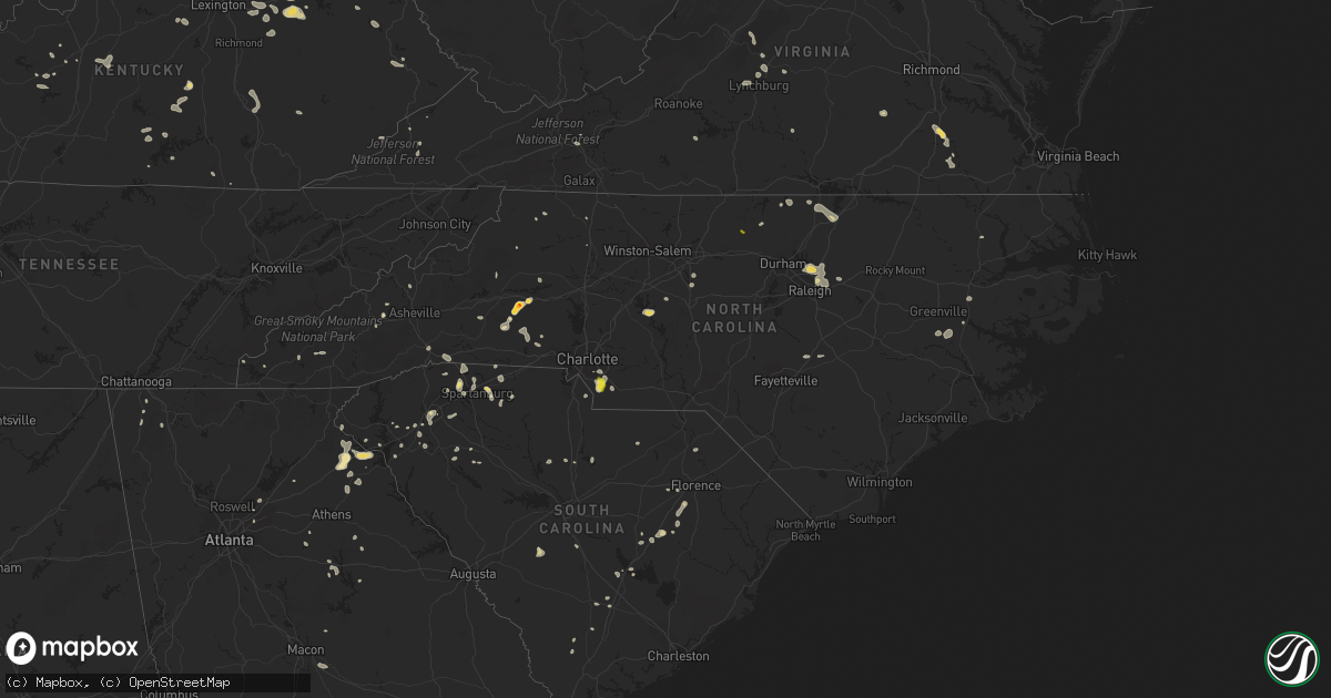
Hail Map in North Carolina on July 6, 2022
Get this storm
July 6 map
$229
one time, instant access
Download today. No call, no setup
Keep the $229
Bought the map and want the full workflow? Apply the entire $229 to a subscription within 7 days. None of it is wasted.
Every map, not just this one
This buys you this map. Subscription and you get every map we run, in the markets you choose from a few cities to whole states to nationwide. Plus real-time alerts the moment a storm fires.
Contact data
Name, contact info, occupancy, even credit band for addresses in the footprint. You go from where it hit to who to call.
Become the source they trust
Unlimited branding weather history reports on demand. You already have the documented answer ready for the property owner, and you are the one who showed up with it.
Property data and RoofTrace estimates
Pull up any address you have got, its value and the exact code rules for that jurisdiction, straight from One Click Code. Then RoofTrace estimates the squares, pitch, and roof value, priced the way you price.
Storm reports in North Carolina
North Carolina
| Date | Description |
|---|---|
| 07/06/20226:56 PM CDT | Trees down. Time estimated by radar. |
| 07/06/20226:46 PM CDT | Tree and powerlines down in the bailey area along pine st. Time estimated by radar. |
| 07/06/20226:42 PM CDT | Trees blown down off spring meadow lane in monroe. |
| 07/06/20226:30 PM CDT | Tree down around the area of middlesex. Time estimated by radar. |
| 07/06/20226:30 PM CDT | Trees down in the area of middlesex area. Time estimated by radar. |
| 07/06/20226:27 PM CDT | Multiple reports came into the call center of down trees and powerlines around the hurdle mills area. Time estimated by radar. |
| 07/06/20226:15 PM CDT | Trees down. |
| 07/06/20226:14 PM CDT | Multiple trees down. |
| 07/06/20226:00 PM CDT | Video shared showing a tree down on a home along jackson oaks ct. Time estimated by radar. |
| 07/06/20225:59 PM CDT | Trees down. |
| 07/06/20225:59 PM CDT | Minor structural damage to house along buffalo rd. |
| 07/06/20225:45 PM CDT | Power outage was caused by fallen trees damaging equipment. |
| 07/06/20225:00 PM CDT | Fallen trees or limbs damaged equipment and resulted in power outage. Time estimated by radar. |
| 07/06/20225:00 PM CDT | Tree down on traphill road. |
| 07/06/20224:55 PM CDT | Tree down on green acres road. |
| 07/06/20224:55 PM CDT | Tree down on red top road. |
| 07/06/20224:55 PM CDT | Tree down on north marley ford road. |
| 07/06/20224:55 PM CDT | Tree down on yellow banks road. |
| 07/06/20224:48 PM CDT | 911 call center reported trees down on structure on w 5th ave |
| 07/06/20224:35 PM CDT | 911 call center reported trees down on el bethel rd |
| 07/06/20224:30 PM CDT | Numerous large limbs and a few trees down near trinity elementary and trinity high schools. |
| 07/06/20224:16 PM CDT | One tree down along curry road. Time estimated by radar. |
| 07/06/20224:15 PM CDT | 911 call center reported numerous trees down and powerlines down on oak grove and bethlehem rd |
| 07/06/20224:14 PM CDT | Power outage was caused by fallen trees damaging equipment. |
| 07/06/20224:12 PM CDT | 911 call center reported trees down on elk mountain scenic hwy |
| 07/06/20224:10 PM CDT | 911 call center reported trees down on tobe bridge rd |
| 07/06/20224:05 PM CDT | Tree down on thomasville road. Time estimated by radar. |
| 07/06/20224:00 PM CDT | 911 call center reported numerous trees down in hendersonville |
| 07/06/20223:45 PM CDT | 911 call center reported trees down on shuford lake rd |
| 07/06/20223:32 PM CDT | 911 call center reported a large tree blocking roadway on bess chapel church rd |
| 07/06/20223:30 PM CDT | 911 call center reported trees and powerlines down on woodrow hoyle rd |
| 07/06/20223:12 PM CDT | 911 call center reported large trees blocking roadway and damaged a bridge on houser farm rd |
| 07/06/20223:00 PM CDT | Several trees down in the town of yadkinville. |
| 07/06/20222:40 PM CDT | Amateur radio reported large trees down on hwy 18 |
| 07/06/20222:21 PM CDT | Report of golf ball sized hail. |
| 07/06/20222:21 PM CDT | Numerous trees down with a few on homes on old laurel road. |
| 07/06/20222:05 PM CDT | Public reported trees down with one on trailer... Roof ripped off house... Destroyed barn from a likely microburst on buzz lowman st |
| 07/06/20222:00 PM CDT | Significant roof damage at a hosiery mill on claude brittain rd in hildebran. |
| 07/06/20221:55 PM CDT | Trees down in bethlehem and along the lake near hwy 16 |
| 07/06/20226:41 AM CDT | At 1141 PM EDT, severe thunderstorms were located along a line extending from near Leechville to near Fort Barnwell, moving southeast at 20 mph. HAZARD...60 mph wind gusts. SOURCE...Radar indicated. IMPACT...Expect damage to roofs, siding, and trees. Locations impacted include... New Bern, Havelock, James City, Trent Woods, River Bend, Belhaven, Swindell Fork, Sladesville, Ransomville, Ponzer, Scranton, Blounts Creek, Pamlico Beach, Maysville, Vanceboro, Askins, Lowland, Cayton, Florence and Fort Barnwell. |
| 07/06/20226:30 AM CDT | At 1129 PM EDT, severe thunderstorms were located along a line extending from near La Grange to 14 miles north of Clinton, moving southeast at 20 mph. HAZARD...60 mph wind gusts. SOURCE...Radar indicated. IMPACT...Expect damage to roofs, siding, and trees. Locations impacted include... Kinston, Warsaw, La Grange, Mount Olive, Kornegay, Deep Run, Bowdens, Beautancus, Albertson, Faison, Pink Hill, Calypso and Sandy Bottom. |
| 07/06/20226:29 AM CDT | At 1128 PM EDT, a severe thunderstorm was located 8 miles northwest of Mount Olive, moving east at 25 mph. HAZARD...60 mph wind gusts. SOURCE...Radar indicated. IMPACT...Expect damage to roofs, siding, and trees. Locations impacted include... Goldsboro, Mount Olive, Walnut Creek, Seven Springs, Mar-Mac, Brogden, Cliffs Of The Neuse State Park, Elroy and Grantham. |
| 07/06/20225:57 AM CDT | At 1057 PM EDT, severe thunderstorms were located along a line extending from Washington to near Grifton to near Walnut Creek, moving southeast at 15 mph. HAZARD...60 mph wind gusts. SOURCE...Radar indicated. IMPACT...Expect damage to roofs, siding, and trees. Locations impacted include... Kinston, Washington, La Grange, River Road, Grifton, Deep Run, Blounts Creek, Vanceboro, Askins, Cayton, Shelmerdine, Calico, Fort Barnwell, Jasper, Dawson, Wilmar, Edward, Graingers, Institute and Bonnerton. |
| 07/06/20225:45 AM CDT | At 1044 PM EDT, a severe thunderstorm was located near Godwin, or 11 miles southeast of Lillington, moving east at 25 mph. HAZARD...60 mph wind gusts. SOURCE...Radar indicated. IMPACT...Expect damage to roofs, siding, and trees. Locations impacted include... Newton Grove, Falcon, Hobbton and Spivey's Corner. |
| 07/06/20225:29 AM CDT | At 1029 PM EDT, severe thunderstorms were located along a line extending from near Westover to near Hinson to near Pactolus, moving east at 25 mph. HAZARD...60 mph wind gusts. SOURCE...Radar indicated. IMPACT...Expect damage to roofs, siding, and trees. Locations impacted include... Washington, Plymouth, Belhaven, Ponzer, Pinetown, Pungo, Columbia, Woodley, Wenona, Hinson, Bayview, Bunyan, Pike Road, Leechville, Sidney Crossroads, Westover, Pleasant Grove, Terra Ceia, Scuppernong and Yeatesville. |
| 07/06/20225:20 AM CDT | At 1020 PM EDT, a severe thunderstorm was located over Pope AFB, or near Fort Bragg, moving east at 20 mph. HAZARD...60 mph wind gusts. SOURCE...Radar indicated. IMPACT...Expect damage to roofs, siding, and trees. Locations impacted include... Fayetteville, Fort Bragg, Dunn, Godwin, Pope AFB, Spring Lake, Erwin, Eastover, Wade and Falcon. |
| 07/06/20225:12 AM CDT | At 1011 PM EDT, severe thunderstorms were located along a line extending from near Colerain to 11 miles southwest of Valhalla to near Windsor, moving east at 25 mph. HAZARD...60 mph wind gusts. SOURCE...Radar indicated. IMPACT...Expect damage to trees and powerlines. Severe thunderstorms will be near... Colerain around 1020 PM EDT. Rockyhock around 1030 PM EDT. Tyner and Valhalla around 1035 PM EDT. Cape Colony around 1045 PM EDT. Belvidere around 1050 PM EDT. Hertford, Winfall, Snug Harbor, Chapanoke and Burgess around 1100 PM EDT.Other locations impacted by these severe thunderstorms include GoosePond, Whites Crossroads, Holiday Island, Arrowhead Beach, SaintJohns, Parkville, Mount Gould, Hancock, Yeopim Station and Wakelon. |
| 07/06/20225:07 AM CDT | At 1006 PM EDT, a severe thunderstorm was located near Williamston, moving southeast at 10 mph. HAZARD...60 mph wind gusts. SOURCE...Radar indicated. IMPACT...Expect damage to roofs, siding, and trees. Locations impacted include... Williamston, Old Ford, Jamesville, Smithwick and Beargrass. |
| 07/06/20224:51 AM CDT | At 951 PM EDT, a severe thunderstorm was located near Smithfield, moving southeast at 20 mph. HAZARD...60 mph wind gusts. SOURCE...Radar indicated. IMPACT...Expect damage to roofs, siding, and trees. Locations impacted include... Goldsboro, Smithfield, Mount Olive, Fremont, Micro, Selma, Pine Level, Kenly, Princeton and Lucama. |
| 07/06/20224:50 AM CDT | At 950 PM EDT, severe thunderstorms were located along a line extending from near Bunn to 6 miles northwest of Bailey to near Zebulon, moving east at 15 mph. HAZARD...60 mph wind gusts. SOURCE...Radar indicated. IMPACT...Expect damage to roofs, siding, and trees. Locations impacted include... Nashville, Zebulon, Bailey, Bunn, Wendell, Spring Hope, Middlesex, Sims, Castalia and Pilot. |
| 07/06/20224:28 AM CDT | At 928 PM EDT, a severe thunderstorm was located near Robersonville, or 12 miles east of Tarboro, moving southeast at 10 mph. HAZARD...60 mph wind gusts. SOURCE...Radar indicated. IMPACT...Expect damage to roofs, siding, and trees. Locations impacted include... Williamston, Robersonville, Gold Point, Hamilton, Oak City, Parmele, Everetts, Hassell and Beargrass. |
| 07/06/20224:17 AM CDT | At 916 PM EDT, a severe thunderstorm was located near Warrenton, moving east at 55 mph. HAZARD...60 mph wind gusts. SOURCE...Radar indicated. IMPACT...Expect damage to roofs, siding, and trees. Locations impacted include... Roanoke Rapids, Warrenton, Halifax, Norlina, Littleton, Weldon, Macon, Medoc Mountain State Park, Lake Gaston and Wise. |
| 07/06/20224:13 AM CDT | At 912 PM EDT, a severe thunderstorm was located 7 miles northwest of Bruce, or 9 miles north of Farmville, moving east at 10 mph. HAZARD...60 mph wind gusts. SOURCE...Radar indicated. IMPACT...Expect damage to roofs, siding, and trees. Locations impacted include... Greenville, Farmville, Bell Arthur, Bruce, Fountain and Falkland. |
| 07/06/20223:31 AM CDT | At 831 PM EDT, severe thunderstorms were located along a line extending from near Nashville to 6 miles east of Elm City, moving northeast at 10 mph. HAZARD...60 mph wind gusts. SOURCE...Radar indicated. IMPACT...Expect damage to roofs, siding, and trees. Locations impacted include... Rocky Mount, Tarboro, Nashville, Wilson, Elm City, Dortches, Red Oak, Princeville, Sharpsburg and Pinetops. |
| 07/06/20222:57 AM CDT | At 756 PM EDT, severe thunderstorms were located along a line extending from near Kells Corner to near Chase City to near Staunton River State Park, moving southeast at 20 mph. HAZARD...60 mph wind gusts. SOURCE...Radar indicated. IMPACT...Expect damage to trees and powerlines. Severe thunderstorms will be near... Buffalo Springs around 810 PM EDT. Chase City around 815 PM EDT. Clarksville around 820 PM EDT. Boydton around 830 PM EDT.Other locations impacted by these severe thunderstorms includeNelson, Spanish Grove, Beechwood, John H Kerr Dam, North View,Finchley, Finneywood, Skipwith, Fairview and Rogers Corner. |
| 07/06/20222:37 AM CDT | At 736 PM EDT, severe thunderstorms were located along a line extending from near Crystal Hill to Ingram to Keeling, moving southeast at 15 mph. HAZARD...60 mph wind gusts. SOURCE...Radar indicated. IMPACT...Expect damage to roofs, siding, and trees. Locations impacted include... South Boston... Halifax... Clover... Turbeville... Ingram... Milton... and Scottsburg. |
| 07/06/20222:28 AM CDT | At 728 PM EDT, severe thunderstorms were located along a line extending from near Durham to 6 miles north of Clayton, moving east at 15 mph. HAZARD...60 mph wind gusts. SOURCE...Radar indicated. IMPACT...Expect damage to roofs, siding, and trees. Locations impacted include... Raleigh, Louisburg, Wake Forest, Zebulon, Franklinton, Bailey, Bunn, Knightdale, Wendell and Rolesville. |
| 07/06/20222:22 AM CDT | At 721 PM EDT, a severe thunderstorm was located 8 miles southeast of Etowah, or 16 miles northeast of Benton, moving east at 20 mph. HAZARD...60 mph wind gusts. SOURCE...Radar indicated. IMPACT...Expect damage to roofs, siding, and trees. Locations impacted include... Etowah, Tellico Plains, Coker Creek, Violet, Bullet Creek, Hiawasse Dam, Hiwassee Ocoee State Park and Unaka. |
| 07/06/20222:13 AM CDT | At 713 PM EDT, a severe thunderstorm was located near Prospect Hill, moving east at 10 mph. HAZARD...60 mph wind gusts and penny size hail. SOURCE...Radar indicated. IMPACT...Expect damage to roofs, siding, and trees. Locations impacted include... Roxboro, Rougemont, Bushy Fork, Lake Michie, Moriah, Surl and Bahama. |
| 07/06/20221:59 AM CDT | At 659 PM EDT, a severe thunderstorm was located 9 miles northwest of Farmville, moving east at 10 mph. HAZARD...60 mph wind gusts and penny size hail. SOURCE...Radar indicated. IMPACT...Expect damage to roofs, siding, and trees. Locations impacted include... Macclesfield and Saratoga. |
| 07/06/20221:49 AM CDT | At 649 PM EDT, a severe thunderstorm was located 7 miles south of Uptown Charlotte, or near Southpark Mall, moving southeast at 10 mph. HAZARD...60 mph wind gusts and quarter size hail. SOURCE...Radar indicated. IMPACT...Minor hail damage to vehicles is expected. Expect wind damage to trees and power lines. Locations impacted include... South Charlotte, East Charlotte, Matthews, Mint Hill, Indian Trail, Weddington, Stallings, Pineville, Wesley Chapel and Waxhaw. |
| 07/06/20221:44 AM CDT | At 644 PM EDT, severe thunderstorms were located along a line extending from 7 miles west of Wake Forest to 8 miles east of Raleigh, moving east at 5 mph. HAZARD...60 mph wind gusts and penny size hail. SOURCE...Radar indicated. IMPACT...Expect damage to roofs, siding, and trees. Locations impacted include... Raleigh, Wake Forest, Zebulon, Knightdale, Wendell, Rolesville, Falls Lake, Falls Lake State Rec Area, Falls Lake Boat Ramp and Purnell. |
| 07/06/20221:25 AM CDT | At 625 PM EDT, a severe thunderstorm was located 7 miles west of Courtland, moving southeast at 20 mph. HAZARD...60 mph wind gusts and penny size hail. SOURCE...Radar indicated. IMPACT...Expect damage to trees and powerlines. This severe thunderstorm will be near... Courtland around 640 PM EDT. Boykins and Newsoms around 650 PM EDT. Hunterdale around 655 PM EDT. Franklin around 700 PM EDT.Other locations impacted by this severe thunderstorm include Sunbeam,Handsom, Riverdale, Sebrell, Branchville, Drewryville, Joyner,Shiloh, Story and Little Texas. |
| 07/06/20221:00 AM CDT | At 559 PM EDT, severe thunderstorms were located along a line extending from 4 miles northwest of Gaffney to 11 miles northwest of York to 3 miles south of Gastonia, moving southeast at 20 mph. HAZARD...60 mph wind gusts and quarter size hail. SOURCE...Radar indicated. IMPACT...Minor hail damage to vehicles is expected. Expect wind damage to trees and power lines. Locations impacted include... Gastonia, Rock Hill, Gaffney, York, Fort Mill, Tega Cay, Clover, Newport and Lesslie. |
| 07/06/202212:59 AM CDT | At 559 PM EDT, a severe thunderstorm was located over Randleman, moving east at 25 mph. HAZARD...60 mph wind gusts. SOURCE...Radar indicated. IMPACT...Expect damage to roofs, siding, and trees. Locations impacted include... High Point, Asheboro, Randleman, North Carolina Zoo, Siler City, Seagrove, Pleasant Garden, Liberty, Ramseur and Franklinville. |
| 07/06/202212:58 AM CDT | At 558 PM EDT, a severe thunderstorm was located near High Rock Lake, or 12 miles northwest of Badin Lake, moving northeast at 20 mph. HAZARD...60 mph wind gusts. SOURCE...Radar indicated. IMPACT...Expect damage to roofs, siding, and trees. Locations impacted include... Denton, Newsom, Gordontown, High Rock Boat Dock Marina, Nc Wildlife Access Boat Launch, High Rock Lake Marina & Campground, Martha, High Rock Lake and High Rock. |
| 07/06/202212:46 AM CDT | At 545 PM EDT, severe thunderstorms were located along a line extending from near Roaring Gap to Hays to near Millers Creek, moving southeast at 40 mph. HAZARD...60 mph wind gusts. SOURCE...Radar indicated. IMPACT...Expect damage to roofs, siding, and trees. Locations impacted include... North Wilkesboro... Elkin... Wilkesboro... Fairview... Yadkinville... Jonesville... and Boonville. |
| 07/06/202212:19 AM CDT | At 519 PM EDT, severe thunderstorms were located along a line extending from 12 miles southeast of Columbus to near Spartanburg to 12 miles east of Greenville Downtown, moving east at 20 mph. HAZARD...60 mph wind gusts and quarter size hail. SOURCE...Radar indicated. IMPACT...Minor hail damage to vehicles is expected. Expect wind damage to trees and power lines. Locations impacted include... Spartanburg, Boiling Springs SC, Duncan, Lyman, Cowpens, Wellford, Inman, Mayo, Roebuck and Chesnee. |
| 07/06/202212:13 AM CDT | At 513 PM EDT, a severe thunderstorm was located near Randleman, moving east at 15 mph. HAZARD...60 mph wind gusts. SOURCE...Radar indicated. IMPACT...Expect damage to roofs, siding, and trees. Locations impacted include... Randleman, Pleasant Garden, Liberty, Ramseur, Franklinville, Staley, Climax, Randleman Regional Reservior Marina and Forest Oaks. |
| 07/06/202212:02 AM CDT | At 501 PM EDT, a severe thunderstorm was located 4 miles southwest of Marshall, moving east at 15 mph. HAZARD...60 mph wind gusts and penny size hail. SOURCE...Radar indicated. IMPACT...Expect damage to trees and power lines. Locations impacted include... Marshall, North Asheville, Woodfin, Weaverville, Mars Hill, Leicester, Flat Creek, Faust, Walnut and Canto. |
| 07/05/202211:59 PM CDT | At 458 PM EDT, severe thunderstorms were located along a line extending from near Marion Wytheville to near Mount Rogers Summit, moving east at 25 mph. HAZARD...60 mph wind gusts and quarter size hail. SOURCE...Radar indicated. IMPACT...Hail damage to vehicles is expected. Expect wind damage to roofs, siding, and trees. Locations impacted include... Wytheville... Galax... Sparta... Rural Retreat... Independence... Fries... and Mouth Of Wilson. |
| 07/05/202211:41 PM CDT | At 440 PM EDT, a severe thunderstorm was located near Clemmons, or 8 miles south of Winston-Salem, moving east at 15 mph. HAZARD...60 mph wind gusts. SOURCE...Radar indicated. IMPACT...Expect damage to roofs, siding, and trees. Locations impacted include... Winston-Salem, High Point, Lexington, Thomasville, Clemmons, Bermuda Run, Arcadia and Welcome. |
| 07/05/202211:30 PM CDT | At 430 PM EDT, severe thunderstorms were located along a line extending from 11 miles northeast of Rutherfordton to 13 miles west of Lincolnton, moving south at 10 mph. HAZARD...60 mph wind gusts and quarter size hail. SOURCE...Radar indicated. IMPACT...Minor hail damage to vehicles is expected. Expect wind damage to trees and power lines. Locations impacted include... Shelby, Forest City, Rutherfordton, Cherryville, Bessemer City, Spindale, Belwood, Lawndale, Fallston and Polkville. |
| 07/05/202211:09 PM CDT | Multiple power outages reported along strawberry branch rd. |
| 07/05/202211:04 PM CDT | At 404 PM EDT, a severe thunderstorm was located 11 miles southeast of Marion, moving east at 15 mph. HAZARD...60 mph wind gusts and quarter size hail. SOURCE...Radar indicated. IMPACT...Minor hail damage to vehicles is expected. Expect wind damage to trees and power lines. Locations impacted include... Sunshine, Thermal City, Fero, Dysartsville, Union Mills and Glenwood. |
| 07/05/202210:50 PM CDT | Utility company reports multiple power outages in an area northwest of new bern. |
| 07/05/202210:45 PM CDT | At 345 PM EDT, severe thunderstorms were located along a line extending from 21 miles south of Spruce Pine to 6 miles southwest of Marion, moving southeast at 5 mph. HAZARD...60 mph wind gusts and quarter size hail. SOURCE...Radar indicated. IMPACT...Minor hail damage to vehicles is expected. Expect wind damage to trees and power lines. Locations impacted include... Old Fort, Shingle Hollow, Sugar Hill, Thermal City, Glenwood, Fero and Union Mills. |
| 07/05/202210:42 PM CDT | At 342 PM EDT, a severe thunderstorm was located near Brooks Crossroads, or near Yadkinville, moving southeast at 15 mph. HAZARD...60 mph wind gusts and quarter size hail. SOURCE...Radar indicated. IMPACT...Hail damage to vehicles is expected. Expect wind damage to roofs, siding, and trees. Locations impacted include... Yadkinville... Jonesville... Boonville... Windy Gap... Nebo... Buck Shoals... and Huntsville. |
| 07/05/202210:41 PM CDT | At 341 PM EDT, a severe thunderstorm was located 10 miles east of Waynesville, or near Canton, moving southeast at 10 mph. HAZARD...60 mph wind gusts and quarter size hail. SOURCE...Radar indicated. IMPACT...Minor hail damage to vehicles is expected. Expect wind damage to trees and power lines. Locations impacted include... Canton, Clyde, Mount Pisgah, Leicester, Enka, Candler, Canto, Cruso, Bent Creek and West Asheville. |
| 07/05/202210:40 PM CDT | At 339 PM EDT, a severe thunderstorm was located 12 miles southeast of Morganton, or 7 miles southwest of Icard, and is nearly stationary. HAZARD...60 mph wind gusts and half dollar size hail. SOURCE...Radar indicated. IMPACT...Minor hail damage to vehicles is expected. Expect wind damage to trees and power lines. Locations impacted include... Casar, Cooksville, Pleasant Grove, Vale, Belwood and South Mountains State Park. |
| 07/05/202210:35 PM CDT | Tree down near country club road. Time estimated by radar. |
| 07/05/202210:30 PM CDT | Tree down near massey road producing a power outage. Time estimated by radar. |
| 07/05/202210:22 PM CDT | Utiliy company reports multiple outages in the dover area. |
| 07/05/20229:56 PM CDT | At 256 PM EDT, a severe thunderstorm was located 6 miles southwest of Hickory, or near Mountain View, and is nearly stationary. HAZARD...60 mph wind gusts and quarter size hail. SOURCE...Radar indicated. IMPACT...Minor hail damage to vehicles is expected. Expect wind damage to trees and power lines. Locations impacted include... Hickory, Longview, Icard, Hildebran, Hickory Regional Airport, Mountain View, Cooksville, Propst, Startown and Connelly Springs. |
| 07/05/20229:45 PM CDT | Multiple reports of trees down in the godwin falcon area. Time estimated by radar. |
| 07/05/20229:43 PM CDT | Tree down along dunn road. Time estimated by radar. |
| 07/05/20229:43 PM CDT | Tree down near the intersection of norris rd and burnett rd. Time estimated by radar. |
| 07/05/20229:42 PM CDT | Tree down along julian road. Time estimated by radar. |
| 07/05/20229:41 PM CDT | Tree down along burnett road. Time estimated by radar. |
| 07/05/20229:40 PM CDT | Tree down near intersection of hwy 82 and w thornton rd. Time estimated by radar. |
| 07/05/20229:30 PM CDT | Spotter reported trees down and shingles blown off a roof. Report relayed via nws wilmington. |
| 07/05/20229:23 PM CDT | Trees down in roadway on nc 171 near wainwright rd. Time estimated from radar. |
| 07/05/20229:12 PM CDT | Trees down in roadway near the intersection of piney grove church rd and tice cemetery rd. Time estimated from radar. |
| 07/05/20229:10 PM CDT | Fallen trees or limbs damaged equipment and resulted in power outage. Time estimated by radar. |
| 07/05/20229:10 PM CDT | Tree down on edwards road. Time estimated by radar. |
| 07/05/20228:55 PM CDT | Tree down on brantley road. Time estimated by radar. |
| 07/05/20228:54 PM CDT | Tree down in the micro... Nc area. Time estimated by radar. |
| 07/05/20228:30 PM CDT | Dispatch reported trees down and cars driving into fallen trees near oak city. |
| 07/05/20228:25 PM CDT | Tree down west of littleton. |
| 07/05/20228:18 PM CDT | Reports of trees down along macon-embro road in macon... Nc. Time estimated by radar. |
| 07/05/20228:07 PM CDT | Trees down northwest of warrenton along ridgway-warrenton road. Time estimated by radar. |
| 07/05/20227:20 PM CDT | Fallen trees or limbs damaged equipment and resulted in power outage. Time estimated by radar. |
| 07/05/20227:16 PM CDT | Trees down. Time estimated by radar. |
| 07/05/20227:11 PM CDT | Trees down in paynes tavern. |
All States Impacted by Hail Map on July 6, 2022
Cities Impacted by Hail Map on July 6, 2022
- Joplin, MT
- Chinook, MT
- Lavina, MT
- Roundup, MT
- Bowman, ND
- Frazer, MT
- Poplar, MT
- Avon, MT
- Hobson, MT
- Buffalo, MT
- Forsyth, MT
- Loma, MT
- Chester, MT
- Ledger, MT
- Fort Benton, MT
- Big Sandy, MT
- Inverness, MT
- Glendive, MT
- Lindsay, MT
- Terry, MT
- Brusett, MT
- Geyser, MT
- Grass Range, MT
- Elkfork, KY
- Sandy Hook, KY
- Axtell, KS
- Corning, KS
- Clearmont, MO
- Greensburg, IN
- Havensville, KS
- Mitchell, OR
- Lame Deer, MT
- Birney, MT
- Glendale, KY
- Cecilia, KY
- Martin, KY
- Banner, KY
- Allen, KY
- Prestonsburg, KY
- Dana, KY
- Apple Grove, WV
- Gallipolis Ferry, WV
- Hamptonville, NC
- Hartford, KY
- Akron, CO
- Max Meadows, VA
- Piedmont, SC
- Pelzer, SC
- Williamston, SC
- Booker, TX
- Perryton, TX
- Balko, OK
- Hettinger, ND
- Mott, ND
- New Leipzig, ND
- New Raymer, CO
- Grover, CO
- Havre, MT
- Kremlin, MT
- Rudyard, MT
- Hingham, MT
- Ryegate, MT
- Stanford, MT
- Shepherd, MT
- Huntley, MT
- Fairmont, NE
- Box Elder, MT
- Cheyenne Wells, CO
- Glenarm, IL
- Chatham, IL
- Hogeland, MT
- Harlem, MT
- Elizabeth, IN
- Towner, ND
- Rugby, ND
- Gillette, WY
- Haddam, KS
- Egnar, CO
- Othello, WA
- Batavia, OH
- Pleasant Plain, OH
- Blanchester, OH
- Goshen, OH
- Rocky Ford, CO
- Manzanola, CO
- Vida, MT
- Richey, MT
- Wolf Point, MT
- Limon, CO
- Matheson, CO
- Jordan, MT
- Cohagen, MT
- Powell, WY
- White Sulphur Springs, MT
- Winnett, MT
- Prineville, OR
- Goff, KS
- Atchison, KS
- Bethune, CO
- Narka, KS
- Culbertson, MT
- Lancaster, MN
- Musselshell, MT
- Gordon, NE
- Rushville, NE
- Malta, MT
- Zortman, MT
- Hays, MT
- Dodson, MT
- Lloyd, MT
- Jefferson City, MT
- Clancy, MT
- Boulder, MT
- Belfield, ND
- Crowley, CO
- Ordway, CO
- Olney Springs, CO
- Fallon, MT
- Hardy, NE
- Fairbury, NE
- Lewistown, MT
- Ingomar, MT
- Sand Springs, MT
- La Junta, CO
- Union Point, GA
- Blue Hill, NE
- Hurdle Mills, NC
- Owingsville, KY
- Mount Sterling, KY
- Frenchburg, KY
- Olympia, KY
- Means, KY
- Hope, KY
- Jeffersonville, KY
- Thompsonville, IL
- Ware Shoals, SC
- Laurens, SC
- McIntosh, SD
- Fort Peck, MT
- Amidon, ND
- Deaver, WY
- Marion, MT
- Raynesford, MT
- Belt, MT
- Morrisonville, IL
- Pawnee, IL
- Lead, SD
- Helmville, MT
- Willow Wood, OH
- Scottown, OH
- Chesapeake, OH
- Merino, CO
- Kila, MT
- Townsend, MT
- Bighorn, MT
- Verdon, NE
- Sebree, KY
- Ellis, KS
- Salt Lick, KY
- Williamsburg, OH
- Bethel, OH
- Georgetown, OH
- Hamersville, OH
- Mount Orab, OH
- Ramah, CO
- Calhan, CO
- Minneola, KS
- Kit Carson, CO
- Franktown, CO
- Castle Rock, CO
- Elbert, CO
- Bridger, MT
- Buffalo, WY
- Kaycee, WY
- Jetmore, KS
- Rineyville, KY
- Watauga, SD
- Selfridge, ND
- Morristown, SD
- Wray, CO
- Williamsport, OH
- Lawson, MO
- Springfield, OH
- South Charleston, OH
- Hinsdale, MT
- Geraldine, MT
- Whiting, KS
- Netawaka, KS
- Horton, KS
- Custer, SD
- Nezperce, ID
- Ferdinand, ID
- New England, ND
- South Heart, ND
- Lathrop, MO
- Turney, MO
- Keystone, SD
- Hermosa, SD
- Wetmore, KS
- Londonderry, OH
- Chillicothe, OH
- Laurelville, OH
- Kingston, OH
- Seneca, KS
- Wathena, KS
- Saint Joseph, MO
- Fort Morgan, CO
- Basin, MT
- Hot Springs, MT
- Plains, MT
- Brockton, MT
- Froid, MT
- Moore, MT
- Moccasin, MT
- Forest Grove, MT
- Craigmont, ID
- Lewiston, ID
- Imnaha, OR
- Enterprise, OR
- Cottonwood, ID
- Elizabethtown, IN
- Ewing, KY
- Mullinville, KS
- Randleman, NC
- Pleasant Garden, NC
- Andersonville, TN
- Heiskell, TN
- Strunk, KY
- Corydon, IN
- Winnsboro, SC
- Winchester, KY
- Inman, SC
- Campobello, SC
- Monroe, NC
- Brockway, MT
- Russell Springs, KY
- Glens Fork, KY
- Columbia, KY
- Ruskin, FL
- Flagler, CO
- Vona, CO
- Sunnyside, WA
- Grandview, WA
- Prosser, WA
- Mabton, WA
- Toppenish, WA
- Plattsburg, MO
- Blackstone, VA
- Seibert, CO
- South Bloomingville, OH
- Glenwood, MO
- Lancaster, MO
- Coatsville, MO
- Larkspur, CO
- Sedalia, CO
- Fayetteville, OH
- Spray, OR
- Belleville, KS
- Munden, KS
- Washington, KS
- Denton, NC
- Trinity, NC
- Lexington, NC
- Rush Center, KS
- Larned, KS
- Henderson, NE
- Sutton, NE
- Grafton, NE
- McCool Junction, NE
- Rozel, KS
- Shubert, NE
- Everest, KS
- Robinson, KS
- Kiowa, CO
- Bennett, CO
- Elizabeth, CO
- Red Cloud, NE
- Albany, KY
- Butlerville, IN
- Manchester, KY
- Bessemer City, NC
- Kings Mountain, NC
- Gurley, AL
- Procious, WV
- Sweetwater, TN
- Athens, TN
- Equality, IL
- Canon, GA
- Murphy, NC
- Waynesville, NC
- Hodgenville, KY
- New Hope, KY
- New Haven, KY
- Bowman, GA
- Royston, GA
- Central, SC
- Lutts, TN
- Sunbright, TN
- East Bernstadt, KY
- Livingston, KY
- Hillsboro, OH
- Lynchburg, OH
- Ayden, NC
- Ringgold, GA
- Laurel Springs, NC
- Pendleton, SC
- Fountain Inn, SC
- Simpsonville, SC
- Abilene, KS
- Spartanburg, SC
- Wellford, SC
- Hanston, KS
- Kinsley, KS
- Tell City, IN
- Ellinwood, KS
- Great Bend, KS
- Lilburn, GA
- Trimble, MO
- Scranton, SC
- Timmonsville, SC
- Olanta, SC
- Tellico Plains, TN
- Lamar, SC
- Matthews, NC
- Waxhaw, NC
- Indian Trail, NC
- Charlotte, NC
- Pacolet, SC
- Bowersville, GA
- Lavonia, GA
- Hartwell, GA
- Clifton Hill, MO
- Huntsville, MO
- Martin, GA
- Carnesville, GA
- Lewisburg, OH
- Linn, KS
- Rockwood, TN
- Maryville, MO
- Pickering, MO
- Strasburg, CO
- Morrowville, KS
- Peyton, CO
- Minneapolis, KS
- Greenville, SC
- Ford, KS
- Spearville, KS
- Hoisington, KS
- Albert, KS
- Olmitz, KS
- McCracken, KS
- Bison, KS
- Otis, KS
- La Crosse, KS
- Crestwood, KY
- La Grange, KY
- Buckner, KY
- Pedro, OH
- Weston, CO
- Capron, VA
- Yale, VA
- Salisbury, NC
- Richfield, NC
- Danielsville, GA
- Wendell, NC
- Raleigh, NC
- Wake Forest, NC
- Knightdale, NC
- Gable, SC
- Alcolu, SC
- New Zion, SC
- Stephens, GA
- Eatonton, GA
- Madison, GA
- Washington Court House, OH
- New Holland, OH
- Mount Sterling, OH
- Casar, NC
- Gladstone, VA
- Appomattox, VA
- Tribune, KS
- Holly, CO
- Marshall, NC
- Tazewell, TN
- Rainsville, AL
- Watertown, TN
- Milton, TN
- Dunn, NC
- Niota, TN
- Elloree, SC
- Santee, SC
- Clyde, NC
- Canton, NC
- Reevesville, SC
- Saint George, SC
- Inavale, NE
- Big Clifty, KY
- Thorn Hill, TN
- Mooresburg, TN
- Bean Station, TN
- Waverly, VA
- Petersburg, VA
- Carson, VA
- Stony Creek, VA
- Disputanta, VA
- Miami, TX
- Rosston, OK
- Rock Hill, SC
- Fort Mill, SC
- Lancaster, SC
- Hickory, NC
- Morganton, NC
- Connelly Springs, NC
- Vale, NC
- Hildebran, NC
- Oxford, NC
- Bullock, NC
- Henderson, NC
- State Road, NC
- Wise, VA
- Coeburn, VA
- Taylorsville, NC
- Ten Mile, TN
- Buckhead, GA
- Philadelphia, TN
- Idalia, CO
- Brownell, KS
- Arcanum, OH
- Jamesport, MO
- Chillicothe, MO
- Stewartsville, MO
- Briggsdale, CO
- Fairfield, NE
- Glenvil, NE
- Fairfax, MO
- Leitchfield, KY
- Flatgap, KY
- Oil Springs, KY
- West Liberty, KY
- Ironton, OH
- Baileyville, KS
- Centralia, KS
- Frankfort, KS
- Vermillion, KS
- Cleveland, TN
- McBee, SC
- Sardinia, OH
- Laverne, OK
- Partridge, KY
- Cumberland, KY
- Clay City, KY
- Irvine, KY
- Clintwood, VA
- Franklin, NC
- Shelby, NC
- Cherryville, NC
- Lawndale, NC
- Good Hope, GA
- Mountville, SC
- Apollo Beach, FL
- Soldier, KS
- Cedar Bluff, AL
- Gaylesville, AL
- Clifton, KS
- Cuba, KS
- Agenda, KS
- Karval, CO
- Simla, CO
- Hugo, CO
- Wild Horse, CO
- Effingham, KS
- Muscotah, KS
- Flemingsburg, KY
- Mayslick, KY
- Clendenin, WV
- Oakdale, TN
- Ashland, KS
- Leopold, IN
- Knoxville, TN
- Nebo, NC
- Belton, SC
- Etowah, TN
- Reliance, TN
- Toccoa, GA
- Westminster, SC
- Saint Matthews, SC
- Swansea, SC
- Turbeville, SC
- Lake City, SC
- Lyman, SC
- Bowman, SC
- Ridgeway, SC
- Jonesville, SC
- Lenoir, NC
- Englewood, TN
- Sumter, SC
- Manning, SC
- Liberty, KY
- Dunnville, KY
- Yosemite, KY
- Luttrell, TN
- Maynardville, TN
- Ruffin, SC
- Borger, TX
- Hollywood, AL
- Scottsboro, AL
- Fackler, AL
- Gainesville, GA
- Society Hill, SC
- Burlington, CO
- Syracuse, KS
- Guilford, MO
- Portsmouth, OH
- McDermott, OH
- Churchville, VA
- Staunton, VA
- Vesuvius, VA
- Hustonville, KY
- Amherst, VA
- Lynchburg, VA
- Forest, VA
- Pound, VA
- Beaver Dam, KY
- Centertown, KY
- Sumerco, WV
- Julian, WV
- Sugar City, CO
- Gaffney, SC
- Jefferson, NC
- Millers Creek, NC
- Landrum, SC
- Anderson, SC
- Eastanollee, GA
- Chocowinity, NC
- Sheridan Lake, CO
- Fraziers Bottom, WV
- Buffalo, WV
- Proctorville, OH
- Offerle, KS
- Clarkson, KY
- Camden, OH
- Vanceboro, NC
- Grimesland, NC
- Greenville, NC
- Lyons, KS
- Crouse, NC
- Smithville, MO
- Saluda, NC
- Columbus, NC
- Tryon, NC
- Rogersville, TN
- Falls City, NE
- Kirk, CO
- Kenna, WV
- Charleston, WV
- Given, WV
- Advent, WV
- Liberty, WV
- Harrodsburg, KY
- Salvisa, KY
- Salley, SC
- Wagener, SC
- Nokesville, VA
- Manassas, VA
- Woodbridge, VA
- Sparta, GA
- Lancing, TN
- Duluth, GA
- Suwanee, GA
- Cimarron, KS
- Greer, SC
- Phenix, VA
- Summerton, SC
- Stearns, KY
- Varnville, SC
- Bazine, KS
- Cross Plains, IN
- Canaan, IN
- Madison, IN
- Bennington, IN
- Versailles, IN
- Liebenthal, KS
- Madison Heights, VA
- Monroe, VA
- Lancaster, KS
- Denton, KS
- McDonald, TN
- Ooltewah, TN
- Raymond, KS
- Wakeeney, KS
- Chase, KS
- Hudson, KS
- St John, KS
- Alexander, KS
- Claflin, KS
- Pawnee Rock, KS
- Boiling Springs, SC
- Caryville, TN
- Franklin, TN
- Corryton, TN
- Kersey, CO
- Orchard, CO
- Weldona, CO
- Gill, CO
- Log Lane Village, CO
- Brush, CO
- Blue Rapids, KS
- Randolph, KS
- Lebanon, KS
- Troy, KS
- Bendena, KS
- Galatia, IL
- Carrier Mills, IL
- East Flat Rock, NC
- Hendersonville, NC
- Flat Rock, NC
- Collinwood, TN
- Eastview, KY
- Gray, GA
- La Fayette, GA
- Leicester, NC
- Townville, SC
- Oliver Springs, TN
- Oak Ridge, TN
- Osborn, MO
- Cameron, MO
- Palouse, WA
- Garfield, WA
- Onaga, KS
- Knightstown, IN
- Oregon, MO
- Forest City, MO
- Maitland, MO
- North Vernon, IN
- Smith Center, KS
- Westport, IN
- Fair Play, SC
- Monticello, KY
- Colerain, NC
- Vance, SC
- Rock Spring, GA
- Honea Path, SC
- Fritch, TX
- Agency, MO
- Easton, MO
- Ellenboro, NC
- Amazonia, MO
- Agate, CO
- Clinton, SC
- Godwin, NC
- Jamestown, KY
- Dry Branch, GA
- Canyon, TX
- Winfield, WV
- Hurricane, WV
- Milton, WV
- Glenwood, WV
- Williamston, NC
- Washington, NC
- Ocala, FL
- Una, SC
- Linden, TN
- Grandview, TN
- Andrews, NC
- Holt, MO
- Elkview, WV
- Walton, WV
- Prospect, KY
- Franklin Furnace, OH
- Sharpsburg, KY
- Moorefield, KY
- Mauldin, SC
- Deer Lodge, TN
- Zebulon, NC
- Islandton, SC
- Saint Albans, WV
- Nitro, WV
- Dunbar, WV
- Scott Depot, WV
- Cleves, OH
- Highland, KS
- Versailles, KY
- Kingston, TN
- Clarksdale, MO
- Helena, MO
- Cosby, MO
- Amity, MO
- Union Star, MO
- Courtland, KS
- Republic, KS
- Scandia, KS
- Crown City, OH
- Wytheville, VA
- Middleburg, KY
- Spring City, TN
- Roxboro, NC
- Social Circle, GA
- Rocky Mount, VA
- Glade Hill, VA
- Branchville, SC
- Lake Bronson, MN
- Outlook, WA
- Glasgow, MT
- Victor, MT
- Byers, CO
- Snyder, CO
- Galeton, CO
- Eaton, CO
- Yuma, CO
- Las Animas, CO
- Lamar, CO
- Lovell, WY
- Fairview, MT
- Nashua, MT
- Hardin, MT
- Crow Agency, MT
- Worden, MT
- Shelby, MT
- Highwood, MT
- Circle, MT
- Lincoln, KS
- Beverly, KS
- Sunman, IN
- Milan, IN
- Osgood, IN
- Moores Hill, IN
- Hebron, KY
- Burlington, KY
- Erlanger, KY
- Florence, KY
- Bellevue, KY
- Ft Mitchell, KY
- Latonia, KY
- Fort Thomas, KY
- Newport, KY
- Cincinnati, OH
- Covington, KY
- Terrace Park, OH
- Milford, OH


