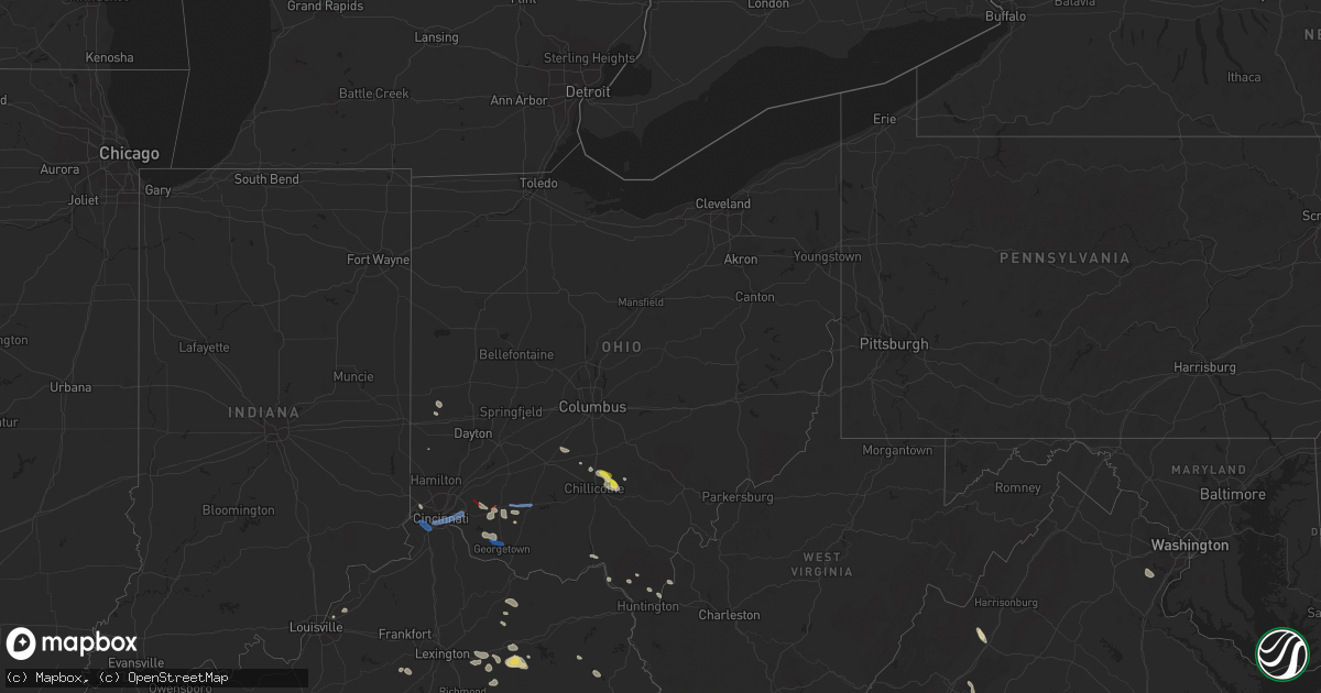
Hail Map in Ohio on July 6, 2022
Get this storm
July 6 map
$229
one time, instant access
Download today. No call, no setup
Keep the $229
Bought the map and want the full workflow? Apply the entire $229 to a subscription within 7 days. None of it is wasted.
Every map, not just this one
This buys you this map. Subscription and you get every map we run, in the markets you choose from a few cities to whole states to nationwide. Plus real-time alerts the moment a storm fires.
Contact data
Name, contact info, occupancy, even credit band for addresses in the footprint. You go from where it hit to who to call.
Become the source they trust
Unlimited branding weather history reports on demand. You already have the documented answer ready for the property owner, and you are the one who showed up with it.
Property data and RoofTrace estimates
Pull up any address you have got, its value and the exact code rules for that jurisdiction, straight from One Click Code. Then RoofTrace estimates the squares, pitch, and roof value, priced the way you price.
Storm reports in Ohio
Ohio
| Date | Description |
|---|---|
| 07/06/20224:29 PM CDT | Tree down at south point. |
| 07/06/20224:18 PM CDT | Tree down at kitts hill. |
| 07/06/20223:51 PM CDT | Multiple trees down |
| 07/06/20223:28 PM CDT | Multiple trees down |
| 07/06/20223:06 PM CDT | Tree fell into power lines. Time estimated from radar. |
| 07/06/20223:04 PM CDT | Pole snapped in half - wires on roadway. Time estimated from radar. |
| 07/06/20222:39 PM CDT | Roof blown off house. Time estimated from radar. |
| 07/06/20222:34 PM CDT | Window shutters blown off house. Time estimated from radar. |
| 07/06/20222:21 PM CDT | Numerous trees and limbs down. Time estimated from radar. |
| 07/06/20222:20 PM CDT | Tree snapped. Time estimated from radar. |
| 07/06/20222:20 PM CDT | Trees down and shingles blown off roof |
| 07/06/20222:17 PM CDT | Nws survey confirms a 3.4 mile tornado which began just southwest of lake lorelei in brown county. The tornado caused widespread damage to large trees... Homes and outb |
| 07/06/20222:17 PM CDT | Nws survey confirms a 3.4 mile tornado which began just southwest of lake lorelei in brown county. The tornado caused widespread damage to large trees... Homes and outb |
| 07/06/20222:16 PM CDT | Numerous trees snapped and uprooted. Time estimated from radar. |
| 07/06/20222:15 PM CDT | Barn roof damaged. A few trees down nearby. Time estimated from radar. |
| 07/06/20222:15 PM CDT | Large limbs broken off. Time estimated from radar. |
| 07/06/20222:14 PM CDT | Barn roof partially peeled back and removed. Time estimated from radar. |
| 07/06/20222:07 PM CDT | Likely tornado hit near goshen township fire station. Time estimated from radar. |
| 07/06/20222:06 PM CDT | *** 2 inj *** nws survey confirms a 4.6 mile tornado which began just southwest of pleasant plain in clermont county. The tornado caused widespread damage to large tree |
| 07/06/20222:02 PM CDT | Eight mature trees down near stoker court. |
| 07/06/20222:00 PM CDT | Large tree down into a home... Causing significant roof damage |
| 07/06/20222:00 PM CDT | Siding of upper level of house ripped off exposing interior room. Numerous trees and large limbs down. |
| 07/06/20221:58 PM CDT | Numerous trees down falling on homes/ fences. Several trees uprooted. Others snapped at trunk. |
| 07/06/20221:58 PM CDT | Large tree down |
| 07/06/20221:57 PM CDT | Roof shingles blown off house on glencrest lane. Time estimated from radar. |
| 07/06/20221:51 PM CDT | A local report indicates 67 MPH wind near KLUK LUNKEN AIRPORT |
| 07/06/20221:48 PM CDT | Large tree down on roe street. |
| 07/06/20221:15 PM CDT | Large tree down |
| 07/06/202212:34 PM CDT | Large limbs also observed down. Time estimated from radar. |
| 07/06/202211:43 AM CDT | Tree down near carillon and s patterson |
| 07/06/202211:33 AM CDT | Medium-sized branches fell. Photo submitted to media. Time estimated from radar. |
| 07/06/20227:31 AM CDT | At 1230 AM EDT, severe thunderstorms were located along a line extending from near Harbor Hills to near Pickerington, moving southeast at 30 mph. HAZARD...60 mph wind gusts and quarter size hail. SOURCE...Radar indicated. IMPACT...Hail damage to vehicles is expected. Expect wind damage to roofs, siding, and trees. Locations impacted include... New Lexington, Somerset, Perry State Forest, Crooksville, Thornville, Junction City and Glenford. |
| 07/06/20227:13 AM CDT | At 1213 AM EDT, a severe thunderstorm was located near Westerville, moving southeast at 40 mph. HAZARD...60 mph wind gusts. SOURCE...Radar indicated. IMPACT...Expect damage to trees and power lines. Locations impacted include... Columbus, Westerville, Reynoldsburg, Gahanna, Heath, Pataskala, Johnstown, Sunbury, Buckeye Lake, Hebron, Minerva Park, Harbor Hills, Beechwood Trails, Easton, Summit Station, Granville South, Thornport, Whitehall, Etna and New Albany.This includes I-70 in Ohio between mile markers 114 and 134. |
| 07/06/20227:08 AM CDT | At 1208 PM EDT, a severe thunderstorm was located over West Milton, moving southeast at 40 mph. HAZARD...60 mph wind gusts and penny size hail. SOURCE...Radar indicated. IMPACT...Expect damage to trees and power lines. Locations impacted include... Dayton, Springfield, Kettering, Beavercreek, Huber Heights, Fairborn, Troy, Trotwood, Vandalia, Englewood, Tipp City, Bellbrook, Moraine, New Carlisle, West Milton, Oakwood, Yellow Springs, Wright-Patterson Afb, West Carrollton and Enon.This includes the following Interstates... I-70 in Ohio between mile markers 17 and 55. I-75 in Ohio between mile markers 48 and 73. |
| 07/06/20227:01 AM CDT | At 1201 AM EDT, a severe thunderstorm was located near Sunbury, moving southeast at 20 mph. HAZARD...60 mph wind gusts. SOURCE...Radar indicated. IMPACT...Expect damage to trees and power lines. Locations impacted include... Johnstown, Sunbury, Galena, Alexandria, Hartford, Interstate 71 at US Route 36/State Route 37 and Olive Green.This includes I-71 in Ohio near mile marker 130, and between milemarkers 136 and 138. |
| 07/06/202212:45 AM CDT | At 545 PM EDT, severe thunderstorms were located along a line extending from near Hurricane to 6 miles southeast of Barboursville, moving southeast at 55 mph. HAZARD...60 mph wind gusts. SOURCE...Radar indicated. IMPACT...Expect damage to roofs, siding, and trees. Locations impacted include... Charleston, Huntington, Nitro, Madison, Hamlin, Beech Fork State Park, Jefferson, South Charleston, St. Albans, Dunbar, Hurricane, Barboursville, Milton, Ona, Culloden, Spurlockville, Institute, Tornado, Alum Creek and Julian.This includes the following highways... Interstate 64 in West Virginia between mile markers 11 and 40, andbetween mile markers 50 and 54. Route 119 between mile markers 43 and 46, and between mile markers48 and 78. |
| 07/06/202212:15 AM CDT | At 514 PM EDT, severe thunderstorms were located along a line extending from 6 miles northeast of Oak Hill to near Lake Vesuvius to Naples, moving east at 50 mph. HAZARD...60 mph wind gusts. SOURCE...Radar indicated. IMPACT...Expect damage to roofs, siding, and trees. Locations impacted include... Huntington, Ashland, Ironton, Jackson, Wellston, Point Pleasant, Gallipolis, Coal Grove, Pomeroy, Oak Hill, Wayne, Rio Grande, Chesapeake, Proctorville, Rutland, Beech Fork State Park, Cannonsburg, Lake Vesuvius, Barboursville and Kenova.This includes the following highways... Interstate 64 in Kentucky between mile markers 181 and 191. Interstate 64 in West Virginia between mile markers 1 and 23. |
| 07/05/202211:48 PM CDT | At 446 PM EDT, severe thunderstorms were located along a line extending from 7 miles north of Clarktown to 6 miles southwest of Letitia to Goddard, moving southeast at 35 mph. HAZARD...60 mph wind gusts and penny size hail. SOURCE...Radar indicated. IMPACT...Expect damage to roofs, siding, and trees. Locations impacted include... Ashland, Ironton, Jackson, Grayson, Coal Grove, Olive Hill, Oak Hill, Rio Grande, Lake Vesuvius, Carter Caves State Park, Grayson Lake State Park, Greenup, Coalton, Gesling, Greenbo Lake, Oldtown, Naples, Load, Letitia and Gallia.This includes Interstate 64 in Kentucky between mile markers 149 and180. |
| 07/05/202210:59 PM CDT | At 359 AM EDT, a severe thunderstorm was located over Groveport, moving east at 35 mph. HAZARD...60 mph wind gusts. SOURCE...Radar indicated. IMPACT...Expect damage to trees and power lines. Locations impacted include... Columbus, Lancaster, Reynoldsburg, Pickerington, Bexley, Canal Winchester, Groveport, Baltimore, Buckeye Lake, Bremen, Millersport, Pleasantville, Fairfield Beach, Obetz, Royalton, Lithopolis, Thurston, Carroll, Rushville and Lockbourne.This includes I-70 in Ohio between mile markers 104 and 113. |
| 07/05/202210:59 PM CDT | At 358 PM EDT, a severe thunderstorm was located over Highland Holiday, moving east at 45 mph. HAZARD...70 mph wind gusts. SOURCE...Radar indicated. IMPACT...Expect considerable tree damage. Damage is likely to mobile homes, roofs, and outbuildings. Locations impacted include... Chillicothe, Greenfield, Waverly, Leesburg, Marshall, Bainbridge, Pike Lake, Rocky Fork Point, Highland Holiday, Cynthiana, North Folk Village, Londonderry, South Salem, Pike County Airport, Mooresville, Samantha, Omega, Knockemstiff, Massieville and Lake White. |
| 07/05/202210:37 PM CDT | At 336 PM EDT, a severe thunderstorm was located near Lynchburg, moving east at 40 mph. HAZARD...70 mph wind gusts. SOURCE...Radar indicated. IMPACT...Expect considerable tree damage. Damage is likely to mobile homes, roofs, and outbuildings. Locations impacted include... Hillsboro, Greenfield, Lynchburg, Leesburg, New Vienna, Marshall, Rocky Fork Point, Highland Holiday, Russell, Rocky Fork Lake, Samantha, Rainsboro, Highland County Airport and Paint Creek State Park. |
| 07/05/202210:18 PM CDT | At 318 PM EDT, a severe thunderstorm was located near Williamsburg, moving east at 45 mph. HAZARD...70 mph wind gusts. SOURCE...Radar indicated. IMPACT...Expect considerable tree damage. Damage is likely to mobile homes, roofs, and outbuildings. Locations impacted include... Hillsboro, Georgetown, Blanchester, Mount Orab, West Union, Bethel, Williamsburg, Lynchburg, Winchester, Marshall, Sardinia, Seaman, Belfast, Rocky Fork Point, Highland Holiday, Russell, Woodville, New Market, Emerald and Russellville. |
| 07/05/20229:44 PM CDT | At 244 PM EDT, a severe thunderstorm was located over Four Bridges, moving east at 30 mph. HAZARD...60 mph wind gusts. SOURCE...Radar indicated. IMPACT...Expect damage to trees and power lines. Locations impacted include... Middletown, Fairfield, Mason, Lebanon, Springboro, Sharonville, Wilmington, Monroe, Loveland, Trenton, Franklin, Springdale, Carlisle, Blanchester, South Middletown, West Chester, Waynesville, Sabina, Morrow and Hunter.This includes the following Interstates... I-71 in Ohio between mile markers 20 and 56. I-75 in Ohio between mile markers 18 and 40. |
| 07/05/20228:24 PM CDT | At 124 PM EDT, a severe thunderstorm was located 10 miles southeast of Kingston, or 12 miles east of Chillicothe, moving southeast at 35 mph. HAZARD...60 mph wind gusts and quarter size hail. SOURCE...Radar indicated. IMPACT...Hail damage to vehicles is expected. Expect wind damage to roofs, siding, and trees. Locations impacted include... Wellston, Mcarthur, Hamden, Coalton, Allensville, Eagle Mills and Byer. |
| 07/05/20228:23 PM CDT | At 123 PM EDT, a severe thunderstorm was located 9 miles southeast of Kingston, moving southeast at 25 mph. HAZARD...Quarter size hail. SOURCE...Radar indicated. IMPACT...Minor damage to vehicles is possible. Locations impacted include... Londonderry, Laurelville, Adelphi, South Bloomingville, Mooresville and Hallsville. |
All States Impacted by Hail Map on July 6, 2022
Cities Impacted by Hail Map on July 6, 2022
- Joplin, MT
- Chinook, MT
- Lavina, MT
- Roundup, MT
- Bowman, ND
- Frazer, MT
- Poplar, MT
- Avon, MT
- Hobson, MT
- Buffalo, MT
- Forsyth, MT
- Loma, MT
- Chester, MT
- Ledger, MT
- Fort Benton, MT
- Big Sandy, MT
- Inverness, MT
- Glendive, MT
- Lindsay, MT
- Terry, MT
- Brusett, MT
- Geyser, MT
- Grass Range, MT
- Elkfork, KY
- Sandy Hook, KY
- Axtell, KS
- Corning, KS
- Clearmont, MO
- Greensburg, IN
- Havensville, KS
- Mitchell, OR
- Lame Deer, MT
- Birney, MT
- Glendale, KY
- Cecilia, KY
- Martin, KY
- Banner, KY
- Allen, KY
- Prestonsburg, KY
- Dana, KY
- Apple Grove, WV
- Gallipolis Ferry, WV
- Hamptonville, NC
- Hartford, KY
- Akron, CO
- Max Meadows, VA
- Piedmont, SC
- Pelzer, SC
- Williamston, SC
- Booker, TX
- Perryton, TX
- Balko, OK
- Hettinger, ND
- Mott, ND
- New Leipzig, ND
- New Raymer, CO
- Grover, CO
- Havre, MT
- Kremlin, MT
- Rudyard, MT
- Hingham, MT
- Ryegate, MT
- Stanford, MT
- Shepherd, MT
- Huntley, MT
- Fairmont, NE
- Box Elder, MT
- Cheyenne Wells, CO
- Glenarm, IL
- Chatham, IL
- Hogeland, MT
- Harlem, MT
- Elizabeth, IN
- Towner, ND
- Rugby, ND
- Gillette, WY
- Haddam, KS
- Egnar, CO
- Othello, WA
- Batavia, OH
- Pleasant Plain, OH
- Blanchester, OH
- Goshen, OH
- Rocky Ford, CO
- Manzanola, CO
- Vida, MT
- Richey, MT
- Wolf Point, MT
- Limon, CO
- Matheson, CO
- Jordan, MT
- Cohagen, MT
- Powell, WY
- White Sulphur Springs, MT
- Winnett, MT
- Prineville, OR
- Goff, KS
- Atchison, KS
- Bethune, CO
- Narka, KS
- Culbertson, MT
- Lancaster, MN
- Musselshell, MT
- Gordon, NE
- Rushville, NE
- Malta, MT
- Zortman, MT
- Hays, MT
- Dodson, MT
- Lloyd, MT
- Jefferson City, MT
- Clancy, MT
- Boulder, MT
- Belfield, ND
- Crowley, CO
- Ordway, CO
- Olney Springs, CO
- Fallon, MT
- Hardy, NE
- Fairbury, NE
- Lewistown, MT
- Ingomar, MT
- Sand Springs, MT
- La Junta, CO
- Union Point, GA
- Blue Hill, NE
- Hurdle Mills, NC
- Owingsville, KY
- Mount Sterling, KY
- Frenchburg, KY
- Olympia, KY
- Means, KY
- Hope, KY
- Jeffersonville, KY
- Thompsonville, IL
- Ware Shoals, SC
- Laurens, SC
- McIntosh, SD
- Fort Peck, MT
- Amidon, ND
- Deaver, WY
- Marion, MT
- Raynesford, MT
- Belt, MT
- Morrisonville, IL
- Pawnee, IL
- Lead, SD
- Helmville, MT
- Willow Wood, OH
- Scottown, OH
- Chesapeake, OH
- Merino, CO
- Kila, MT
- Townsend, MT
- Bighorn, MT
- Verdon, NE
- Sebree, KY
- Ellis, KS
- Salt Lick, KY
- Williamsburg, OH
- Bethel, OH
- Georgetown, OH
- Hamersville, OH
- Mount Orab, OH
- Ramah, CO
- Calhan, CO
- Minneola, KS
- Kit Carson, CO
- Franktown, CO
- Castle Rock, CO
- Elbert, CO
- Bridger, MT
- Buffalo, WY
- Kaycee, WY
- Jetmore, KS
- Rineyville, KY
- Watauga, SD
- Selfridge, ND
- Morristown, SD
- Wray, CO
- Williamsport, OH
- Lawson, MO
- Springfield, OH
- South Charleston, OH
- Hinsdale, MT
- Geraldine, MT
- Whiting, KS
- Netawaka, KS
- Horton, KS
- Custer, SD
- Nezperce, ID
- Ferdinand, ID
- New England, ND
- South Heart, ND
- Lathrop, MO
- Turney, MO
- Keystone, SD
- Hermosa, SD
- Wetmore, KS
- Londonderry, OH
- Chillicothe, OH
- Laurelville, OH
- Kingston, OH
- Seneca, KS
- Wathena, KS
- Saint Joseph, MO
- Fort Morgan, CO
- Basin, MT
- Hot Springs, MT
- Plains, MT
- Brockton, MT
- Froid, MT
- Moore, MT
- Moccasin, MT
- Forest Grove, MT
- Craigmont, ID
- Lewiston, ID
- Imnaha, OR
- Enterprise, OR
- Cottonwood, ID
- Elizabethtown, IN
- Ewing, KY
- Mullinville, KS
- Randleman, NC
- Pleasant Garden, NC
- Andersonville, TN
- Heiskell, TN
- Strunk, KY
- Corydon, IN
- Winnsboro, SC
- Winchester, KY
- Inman, SC
- Campobello, SC
- Monroe, NC
- Brockway, MT
- Russell Springs, KY
- Glens Fork, KY
- Columbia, KY
- Ruskin, FL
- Flagler, CO
- Vona, CO
- Sunnyside, WA
- Grandview, WA
- Prosser, WA
- Mabton, WA
- Toppenish, WA
- Plattsburg, MO
- Blackstone, VA
- Seibert, CO
- South Bloomingville, OH
- Glenwood, MO
- Lancaster, MO
- Coatsville, MO
- Larkspur, CO
- Sedalia, CO
- Fayetteville, OH
- Spray, OR
- Belleville, KS
- Munden, KS
- Washington, KS
- Denton, NC
- Trinity, NC
- Lexington, NC
- Rush Center, KS
- Larned, KS
- Henderson, NE
- Sutton, NE
- Grafton, NE
- McCool Junction, NE
- Rozel, KS
- Shubert, NE
- Everest, KS
- Robinson, KS
- Kiowa, CO
- Bennett, CO
- Elizabeth, CO
- Red Cloud, NE
- Albany, KY
- Butlerville, IN
- Manchester, KY
- Bessemer City, NC
- Kings Mountain, NC
- Gurley, AL
- Procious, WV
- Sweetwater, TN
- Athens, TN
- Equality, IL
- Canon, GA
- Murphy, NC
- Waynesville, NC
- Hodgenville, KY
- New Hope, KY
- New Haven, KY
- Bowman, GA
- Royston, GA
- Central, SC
- Lutts, TN
- Sunbright, TN
- East Bernstadt, KY
- Livingston, KY
- Hillsboro, OH
- Lynchburg, OH
- Ayden, NC
- Ringgold, GA
- Laurel Springs, NC
- Pendleton, SC
- Fountain Inn, SC
- Simpsonville, SC
- Abilene, KS
- Spartanburg, SC
- Wellford, SC
- Hanston, KS
- Kinsley, KS
- Tell City, IN
- Ellinwood, KS
- Great Bend, KS
- Lilburn, GA
- Trimble, MO
- Scranton, SC
- Timmonsville, SC
- Olanta, SC
- Tellico Plains, TN
- Lamar, SC
- Matthews, NC
- Waxhaw, NC
- Indian Trail, NC
- Charlotte, NC
- Pacolet, SC
- Bowersville, GA
- Lavonia, GA
- Hartwell, GA
- Clifton Hill, MO
- Huntsville, MO
- Martin, GA
- Carnesville, GA
- Lewisburg, OH
- Linn, KS
- Rockwood, TN
- Maryville, MO
- Pickering, MO
- Strasburg, CO
- Morrowville, KS
- Peyton, CO
- Minneapolis, KS
- Greenville, SC
- Ford, KS
- Spearville, KS
- Hoisington, KS
- Albert, KS
- Olmitz, KS
- McCracken, KS
- Bison, KS
- Otis, KS
- La Crosse, KS
- Crestwood, KY
- La Grange, KY
- Buckner, KY
- Pedro, OH
- Weston, CO
- Capron, VA
- Yale, VA
- Salisbury, NC
- Richfield, NC
- Danielsville, GA
- Wendell, NC
- Raleigh, NC
- Wake Forest, NC
- Knightdale, NC
- Gable, SC
- Alcolu, SC
- New Zion, SC
- Stephens, GA
- Eatonton, GA
- Madison, GA
- Washington Court House, OH
- New Holland, OH
- Mount Sterling, OH
- Casar, NC
- Gladstone, VA
- Appomattox, VA
- Tribune, KS
- Holly, CO
- Marshall, NC
- Tazewell, TN
- Rainsville, AL
- Watertown, TN
- Milton, TN
- Dunn, NC
- Niota, TN
- Elloree, SC
- Santee, SC
- Clyde, NC
- Canton, NC
- Reevesville, SC
- Saint George, SC
- Inavale, NE
- Big Clifty, KY
- Thorn Hill, TN
- Mooresburg, TN
- Bean Station, TN
- Waverly, VA
- Petersburg, VA
- Carson, VA
- Stony Creek, VA
- Disputanta, VA
- Miami, TX
- Rosston, OK
- Rock Hill, SC
- Fort Mill, SC
- Lancaster, SC
- Hickory, NC
- Morganton, NC
- Connelly Springs, NC
- Vale, NC
- Hildebran, NC
- Oxford, NC
- Bullock, NC
- Henderson, NC
- State Road, NC
- Wise, VA
- Coeburn, VA
- Taylorsville, NC
- Ten Mile, TN
- Buckhead, GA
- Philadelphia, TN
- Idalia, CO
- Brownell, KS
- Arcanum, OH
- Jamesport, MO
- Chillicothe, MO
- Stewartsville, MO
- Briggsdale, CO
- Fairfield, NE
- Glenvil, NE
- Fairfax, MO
- Leitchfield, KY
- Flatgap, KY
- Oil Springs, KY
- West Liberty, KY
- Ironton, OH
- Baileyville, KS
- Centralia, KS
- Frankfort, KS
- Vermillion, KS
- Cleveland, TN
- McBee, SC
- Sardinia, OH
- Laverne, OK
- Partridge, KY
- Cumberland, KY
- Clay City, KY
- Irvine, KY
- Clintwood, VA
- Franklin, NC
- Shelby, NC
- Cherryville, NC
- Lawndale, NC
- Good Hope, GA
- Mountville, SC
- Apollo Beach, FL
- Soldier, KS
- Cedar Bluff, AL
- Gaylesville, AL
- Clifton, KS
- Cuba, KS
- Agenda, KS
- Karval, CO
- Simla, CO
- Hugo, CO
- Wild Horse, CO
- Effingham, KS
- Muscotah, KS
- Flemingsburg, KY
- Mayslick, KY
- Clendenin, WV
- Oakdale, TN
- Ashland, KS
- Leopold, IN
- Knoxville, TN
- Nebo, NC
- Belton, SC
- Etowah, TN
- Reliance, TN
- Toccoa, GA
- Westminster, SC
- Saint Matthews, SC
- Swansea, SC
- Turbeville, SC
- Lake City, SC
- Lyman, SC
- Bowman, SC
- Ridgeway, SC
- Jonesville, SC
- Lenoir, NC
- Englewood, TN
- Sumter, SC
- Manning, SC
- Liberty, KY
- Dunnville, KY
- Yosemite, KY
- Luttrell, TN
- Maynardville, TN
- Ruffin, SC
- Borger, TX
- Hollywood, AL
- Scottsboro, AL
- Fackler, AL
- Gainesville, GA
- Society Hill, SC
- Burlington, CO
- Syracuse, KS
- Guilford, MO
- Portsmouth, OH
- McDermott, OH
- Churchville, VA
- Staunton, VA
- Vesuvius, VA
- Hustonville, KY
- Amherst, VA
- Lynchburg, VA
- Forest, VA
- Pound, VA
- Beaver Dam, KY
- Centertown, KY
- Sumerco, WV
- Julian, WV
- Sugar City, CO
- Gaffney, SC
- Jefferson, NC
- Millers Creek, NC
- Landrum, SC
- Anderson, SC
- Eastanollee, GA
- Chocowinity, NC
- Sheridan Lake, CO
- Fraziers Bottom, WV
- Buffalo, WV
- Proctorville, OH
- Offerle, KS
- Clarkson, KY
- Camden, OH
- Vanceboro, NC
- Grimesland, NC
- Greenville, NC
- Lyons, KS
- Crouse, NC
- Smithville, MO
- Saluda, NC
- Columbus, NC
- Tryon, NC
- Rogersville, TN
- Falls City, NE
- Kirk, CO
- Kenna, WV
- Charleston, WV
- Given, WV
- Advent, WV
- Liberty, WV
- Harrodsburg, KY
- Salvisa, KY
- Salley, SC
- Wagener, SC
- Nokesville, VA
- Manassas, VA
- Woodbridge, VA
- Sparta, GA
- Lancing, TN
- Duluth, GA
- Suwanee, GA
- Cimarron, KS
- Greer, SC
- Phenix, VA
- Summerton, SC
- Stearns, KY
- Varnville, SC
- Bazine, KS
- Cross Plains, IN
- Canaan, IN
- Madison, IN
- Bennington, IN
- Versailles, IN
- Liebenthal, KS
- Madison Heights, VA
- Monroe, VA
- Lancaster, KS
- Denton, KS
- McDonald, TN
- Ooltewah, TN
- Raymond, KS
- Wakeeney, KS
- Chase, KS
- Hudson, KS
- St John, KS
- Alexander, KS
- Claflin, KS
- Pawnee Rock, KS
- Boiling Springs, SC
- Caryville, TN
- Franklin, TN
- Corryton, TN
- Kersey, CO
- Orchard, CO
- Weldona, CO
- Gill, CO
- Log Lane Village, CO
- Brush, CO
- Blue Rapids, KS
- Randolph, KS
- Lebanon, KS
- Troy, KS
- Bendena, KS
- Galatia, IL
- Carrier Mills, IL
- East Flat Rock, NC
- Hendersonville, NC
- Flat Rock, NC
- Collinwood, TN
- Eastview, KY
- Gray, GA
- La Fayette, GA
- Leicester, NC
- Townville, SC
- Oliver Springs, TN
- Oak Ridge, TN
- Osborn, MO
- Cameron, MO
- Palouse, WA
- Garfield, WA
- Onaga, KS
- Knightstown, IN
- Oregon, MO
- Forest City, MO
- Maitland, MO
- North Vernon, IN
- Smith Center, KS
- Westport, IN
- Fair Play, SC
- Monticello, KY
- Colerain, NC
- Vance, SC
- Rock Spring, GA
- Honea Path, SC
- Fritch, TX
- Agency, MO
- Easton, MO
- Ellenboro, NC
- Amazonia, MO
- Agate, CO
- Clinton, SC
- Godwin, NC
- Jamestown, KY
- Dry Branch, GA
- Canyon, TX
- Winfield, WV
- Hurricane, WV
- Milton, WV
- Glenwood, WV
- Williamston, NC
- Washington, NC
- Ocala, FL
- Una, SC
- Linden, TN
- Grandview, TN
- Andrews, NC
- Holt, MO
- Elkview, WV
- Walton, WV
- Prospect, KY
- Franklin Furnace, OH
- Sharpsburg, KY
- Moorefield, KY
- Mauldin, SC
- Deer Lodge, TN
- Zebulon, NC
- Islandton, SC
- Saint Albans, WV
- Nitro, WV
- Dunbar, WV
- Scott Depot, WV
- Cleves, OH
- Highland, KS
- Versailles, KY
- Kingston, TN
- Clarksdale, MO
- Helena, MO
- Cosby, MO
- Amity, MO
- Union Star, MO
- Courtland, KS
- Republic, KS
- Scandia, KS
- Crown City, OH
- Wytheville, VA
- Middleburg, KY
- Spring City, TN
- Roxboro, NC
- Social Circle, GA
- Rocky Mount, VA
- Glade Hill, VA
- Branchville, SC
- Lake Bronson, MN
- Outlook, WA
- Glasgow, MT
- Victor, MT
- Byers, CO
- Snyder, CO
- Galeton, CO
- Eaton, CO
- Yuma, CO
- Las Animas, CO
- Lamar, CO
- Lovell, WY
- Fairview, MT
- Nashua, MT
- Hardin, MT
- Crow Agency, MT
- Worden, MT
- Shelby, MT
- Highwood, MT
- Circle, MT
- Lincoln, KS
- Beverly, KS
- Sunman, IN
- Milan, IN
- Osgood, IN
- Moores Hill, IN
- Hebron, KY
- Burlington, KY
- Erlanger, KY
- Florence, KY
- Bellevue, KY
- Ft Mitchell, KY
- Latonia, KY
- Fort Thomas, KY
- Newport, KY
- Cincinnati, OH
- Covington, KY
- Terrace Park, OH
- Milford, OH


