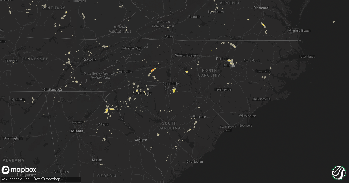
Hail Map on July 6, 2022
Get this storm
July 6 map
$229
one time, instant access
Download today. No call, no setup
Keep the $229
Bought the map and want the full workflow? Apply the entire $229 to a subscription within 7 days. None of it is wasted.
Every map, not just this one
This buys you this map. Subscription and you get every map we run, in the markets you choose from a few cities to whole states to nationwide. Plus real-time alerts the moment a storm fires.
Contact data
Name, contact info, occupancy, even credit band for addresses in the footprint. You go from where it hit to who to call.
Become the source they trust
Unlimited branding weather history reports on demand. You already have the documented answer ready for the property owner, and you are the one who showed up with it.
Property data and RoofTrace estimates
Pull up any address you have got, its value and the exact code rules for that jurisdiction, straight from One Click Code. Then RoofTrace estimates the squares, pitch, and roof value, priced the way you price.
States Impacted by Hail Map on July 6, 2022
Storm reports
Virginia
| Date | Description |
|---|---|
| 07/06/20226:58 PM CDT | Trees down on river road. Time estimated by radar. |
| 07/06/20226:37 PM CDT | Correction of report source to public. Thunderstorm winds blew the top three feet of a healthy sycamore tree down along a pond between johns creek and the 17300 block o |
| 07/06/20226:25 PM CDT | Couple of trees down in saxe. |
| 07/06/20226:24 PM CDT | Thunderstorm winds blew down one tree along paint bank road close to the paint bank general store. |
| 07/06/20226:09 PM CDT | Several trees down in charlotte courthouse. |
| 07/06/20226:05 PM CDT | Two trees down on south lee highway near high bridge church road. |
| 07/06/20225:56 PM CDT | Trees down on cub creek church road. Time estimated by radar. |
| 07/06/20225:54 PM CDT | Trees down on scuffletown road. Time estimated by radar. |
| 07/06/20225:49 PM CDT | Numerous trees down across the county. Vdot and law enforcement working several road closures due to downed trees. |
| 07/06/20225:45 PM CDT | Numerous trees down in phenix. |
| 07/06/20225:43 PM CDT | Trees down route 607 near old courthouse rd. |
| 07/06/20225:43 PM CDT | Trees down on burkeville rd. |
| 07/06/20225:41 PM CDT | Trees down on route 609 near capron. |
| 07/06/20225:30 PM CDT | Wires down. |
| 07/06/20225:30 PM CDT | Trees down on route 628 near burkeville. |
| 07/06/20225:26 PM CDT | Trees and power lines down. |
| 07/06/20225:25 PM CDT | Tree down. Time estimated. |
| 07/06/20225:20 PM CDT | Wires down. Time estimated. |
| 07/06/20225:15 PM CDT | Tree down. Time estimated. |
| 07/06/20225:10 PM CDT | Tree down. Time estimated. |
| 07/06/20225:10 PM CDT | Tree down. Time estimated. |
| 07/06/20225:05 PM CDT | Wire down. |
| 07/06/20225:05 PM CDT | Trees down partially blocking route 45. |
| 07/06/20225:05 PM CDT | Trees down. |
| 07/06/20225:05 PM CDT | Trees down. |
| 07/06/20225:00 PM CDT | Multiple power outages reported. |
| 07/06/20225:00 PM CDT | Tree down along prince edward hwy in farmville... Va. Time estimated. |
| 07/06/20224:56 PM CDT | Tree down on roadway. |
| 07/06/20224:55 PM CDT | Multiple trees down along north creek road and oakville road. |
| 07/06/20224:47 PM CDT | Trees down along route 40. |
| 07/06/20224:44 PM CDT | Tree down on paradise road. |
| 07/06/20224:42 PM CDT | Tree down on bent creek road. |
| 07/06/20224:41 PM CDT | Tree down along spring grove road. |
| 07/06/20224:34 PM CDT | Several trees down across southern portions of buckingham county in the toga area. |
| 07/06/20224:25 PM CDT | Tree down. Time estimated. |
| 07/06/20224:20 PM CDT | Numerous power outages and trees down in southern prince george along route 35. |
| 07/06/20224:00 PM CDT | Corrects previous tstm wnd dmg report from 2 se marion. Corrects previous tstm wnd dmg report from 1 se marion. Trees down on highway 16 outside marion. |
| 07/06/20223:55 PM CDT | Trees down on highway 16 outside marion. |
| 07/06/20223:55 PM CDT | Corrects previous tstm wnd dmg report from 1 se marion. Trees down on highway 16 outside marion. |
| 07/06/20223:55 PM CDT | Several trees down on highway 60 west. |
| 07/06/20223:30 PM CDT | Corrects previous non-tstm wnd dmg report from 2 wsw fairfield. Several trees down along the interstate. |
| 07/06/20223:30 PM CDT | Tree down on lyndhurst road. |
| 07/06/20223:27 PM CDT | Several reports of trees down across eastern augusta county. |
| 07/06/20223:16 PM CDT | Several large limbs down along clearfork road. |
| 07/06/20223:09 PM CDT | Multiple trees down in 100 block of first street. |
| 07/06/20223:06 PM CDT | Several reports of trees down throughout the city of staunton. |
| 07/06/20223:02 PM CDT | Multiple trees down and power lines down on aiken street in staunton. |
| 07/06/20222:59 PM CDT | Tree down on a car on devon road. |
| 07/06/20222:51 PM CDT | Tree down on a car on churchville avenue near intersection with eastwood drive. |
| 07/06/20222:49 PM CDT | Siding torn off the side of a home in churchville. |
| 07/06/20222:06 PM CDT | Multiple trees down in the pound area. |
| 07/06/20222:01 PM CDT | Thunderstorm winds blew down seven trees along 20th street ne. |
| 07/06/20223:10 AM CDT | At 809 PM EDT, severe thunderstorms were located along a line extending from near Clarksville to near Cluster Springs, moving southeast at 25 mph. In addition, an outflow boundary surging southward well ahead of the storms is producing wind gusts of up to 40 mph. HAZARD...60 mph wind gusts. SOURCE...Radar indicated. IMPACT...Expect damage to roofs, siding, and trees. Locations impacted include... Henderson, Oxford, Roxboro, Warrenton, Norlina, Concord, Stovall, Middleburg, Mayo Reservoir and Steele Creek Marina & Campground. |
| 07/06/20222:53 AM CDT | At 753 PM EDT, severe thunderstorms were located along a line extending from Ehkhorn Mine to Hallie, moving southeast at 25 mph. HAZARD...60 mph wind gusts and nickel size hail. SOURCE...Radar indicated. IMPACT...Expect damage to roofs, siding, and trees. Severe thunderstorms will be near... Fleming-Neon around 800 PM EDT. Jenkins around 805 PM EDT. Burdine around 810 PM EDT.Other locations in the path of these severe thunderstorms include Dayand Oven Fork. |
| 07/06/20222:46 AM CDT | At 746 PM EDT, a severe thunderstorm was located over New Castle, moving southeast at 15 mph. HAZARD...60 mph wind gusts and quarter size hail. SOURCE...Radar indicated. IMPACT...Hail damage to vehicles is expected. Expect wind damage to roofs, siding, and trees. Locations impacted include... Roanoke... Salem... Vinton... Troutville... New Castle... Stewartsville... and Montvale.This includes The following Locations The Salem Fairgrounds andRoanoke Regional Airport. |
| 07/06/20222:27 AM CDT | At 727 PM EDT, a severe thunderstorm was located over Saxe, or 8 miles northeast of Clover, moving southeast at 20 mph. HAZARD...60 mph wind gusts. SOURCE...Radar indicated. IMPACT...Expect damage to roofs, siding, and trees. Locations impacted include... Charlotte Court House... Redoak... Clover... Drakes Branch... Mt Laurel... Wylliesburg... and Saxe. |
| 07/06/20222:20 AM CDT | At 720 PM EDT, a severe thunderstorm was located over Paint Bank, moving southeast at 20 mph. HAZARD...60 mph wind gusts and quarter size hail. SOURCE...Radar indicated. IMPACT...Hail damage to vehicles is expected. Expect wind damage to roofs, siding, and trees. Locations impacted include... New Castle... Paint Bank... Sinking Creek... Abbott... Sweet Springs... Craig Springs... and Moncove Lake State Park. |
| 07/06/20222:18 AM CDT | At 718 PM EDT, a severe thunderstorm was located over Leda, or near Mt Airy, moving southeast at 10 mph. HAZARD...60 mph wind gusts and quarter size hail. SOURCE...Radar indicated. IMPACT...Hail damage to vehicles is expected. Expect wind damage to roofs, siding, and trees. Locations impacted include... South Boston... Halifax... Nathalie... Mt Laurel... Cody... Leda... and Crystal Hill. |
| 07/06/20221:44 AM CDT | At 644 PM EDT, severe thunderstorms were located along a line extending from near Spainville to near Blackstone to near Kenbridge, moving southeast at 45 mph. HAZARD...60 mph wind gusts. SOURCE...Radar indicated. IMPACT...Expect damage to trees and powerlines. Severe thunderstorms will be near... Fort Pickett around 650 PM EDT. Wilsons around 655 PM EDT. Dundas around 700 PM EDT. McKenney around 705 PM EDT. Alberta around 710 PM EDT. Dinwiddie, Lawrenceville and Dewitt around 715 PM EDT. Purdy around 725 PM EDT. Jarratt, Stony Creek and Radium around 730 PM EDT.Other locations impacted by these severe thunderstorms include NorthWellville, Cochran, Irby, Gills Corner, Bufford Crossroads, Dolphin,Earls, Murdocks, Pleasant Shade and Forkland. |
| 07/06/20221:42 AM CDT | At 642 PM EDT, a severe thunderstorm was located near Glen Wilton, or near Covington, moving southeast at 25 mph. HAZARD...60 mph wind gusts and quarter size hail. SOURCE...Radar indicated. IMPACT...Hail damage to vehicles is expected. Expect wind damage to roofs, siding, and trees. Locations impacted include... Covington... Clifton Forge... Buchanan... Eagle Rock... Iron Gate... Low Moor... and Springwood. |
| 07/06/20221:34 AM CDT | At 634 PM EDT, a severe thunderstorm was located over Phenix, moving southeast at 10 mph. HAZARD...60 mph wind gusts and quarter size hail. SOURCE...Radar indicated. IMPACT...Hail damage to vehicles is expected. Expect wind damage to roofs, siding, and trees. Locations impacted include... Keysville... Charlotte Court House... Phenix... Drakes Branch... Cullen... Saxe... and Aspen. |
| 07/06/20221:06 AM CDT | At 605 PM EDT, severe thunderstorms were located along a line extending from Cumberland to near Rice to near Abilene, moving southeast at 45 mph. An additional isolated storm has also developed out ahead of the line across northeastern Nottoway County. HAZARD...60 mph wind gusts and quarter size hail. SOURCE...Radar indicated. IMPACT...Minor damage to vehicles is possible. Expect wind damage to trees and powerlines. Severe thunderstorms will be near... Rice around 610 PM EDT. Burkeville and Sunnyside around 615 PM EDT. Crewe, Morven and Jetersville around 620 PM EDT. Green Bay around 625 PM EDT. Amelia Courthouse and Nottoway around 630 PM EDT. Blackstone, Victoria, Spainville, Scotts Fork and Chula around 635 PM EDT. Kenbridge, Wilsons and Fort Pickett around 640 PM EDT. Mannboro and Dundas around 645 PM EDT.Other locations impacted by these severe thunderstorms include NorthWellville, Angola, Ammon, Murdocks, Nutbush, Wellville, BlackstoneAirport, Denaro, Rawlings and Barrows Store. |
| 07/06/202212:42 AM CDT | At 542 PM EDT, a severe thunderstorm was located near Sussex, or 10 miles southwest of Waverly, moving southeast at 20 mph. HAZARD...60 mph wind gusts and quarter size hail. SOURCE...Radar indicated. IMPACT...Minor damage to vehicles is possible. Expect wind damage to trees and powerlines. This severe thunderstorm will be near... Homeville around 550 PM EDT. Courtland and Sedley around 630 PM EDT.Other locations impacted by this severe thunderstorm includeVicksville, Dory, Berlin, Booker, Yale, Lumberton, Sebrell, Manry,Joyner and Worrell. |
| 07/06/202212:35 AM CDT | At 534 PM EDT, severe thunderstorms were located along a line extending from near Centenary to near Toga to near Spring Mills, moving southeast at 30 mph. HAZARD...60 mph wind gusts and penny size hail. SOURCE...Radar indicated. IMPACT...Expect damage to trees and powerlines. Severe thunderstorms will be near... Prospect around 600 PM EDT. Farmville and Darlington Heights around 605 PM EDT. Hampden Sydney and Guinea Mills around 610 PM EDT. Cumberland, Hampden Sydney College and Longwood University around 615 PM EDT. Rice around 625 PM EDT. Green Bay around 630 PM EDT.Other locations impacted by these severe thunderstorms include RainesTavern, Briery Creek Lake, Trents Mill, Tuggle, Prince EdwardStation, Angola, Briery, Twin Lakes State Park, Allens Mill andMcRae. |
| 07/06/202212:11 AM CDT | At 511 PM EDT, severe thunderstorms were located along a line extending from near Schuyler to near Wingina to near Riverville to Bocock, moving east at 35 mph. HAZARD...60 mph wind gusts and quarter size hail. SOURCE...Radar indicated. IMPACT...Hail damage to vehicles is expected. Expect wind damage to roofs, siding, and trees. Locations impacted include... Buckingham... Appomattox... Dillwyn... Bent Creek... Concord... Rustburg... and Pamplin City. |
| 07/06/202212:01 AM CDT | At 500 PM EDT, severe thunderstorms were located along a line extending from 6 miles north of Schuyler to near Shipman, moving southeast at 25 mph. HAZARD...60 mph wind gusts. SOURCE...Radar indicated. IMPACT...Damaging winds will cause some trees and large branches to fall. This could injure those outdoors, as well as damage homes and vehicles. Roadways may become blocked by downed trees. Localized power outages are possible. Unsecured light objects may become projectiles. Locations impacted include... Shipman, Schuyler, Arrington, Scottsville, Esmont, Lovingston, Tye River, Damon, Allens Creek, Covesville, Rockfish, Buffalo Springs, Norwood, Glendower, Keene, Five Forks, Alberene, Wingina, Gladstone and Elma. |
| 07/06/202212:00 AM CDT | At 500 PM EDT, a severe thunderstorm was located near Petersburg, moving southeast at 20 mph. HAZARD...60 mph wind gusts. SOURCE...Radar indicated. IMPACT...Expect damage to trees and powerlines. This severe thunderstorm will be near... Carson around 510 PM EDT. Disputanta around 525 PM EDT.Other locations impacted by this severe thunderstorm includeNewville, Richard Bland College, Burgess, Templeton, Booker, Reamsand Prince George Golf. |
| 07/05/202211:49 PM CDT | At 449 PM EDT, severe thunderstorms were located along a line extending from near Lowesville to near Naola to near Coleman Falls, moving southeast at 15 mph. HAZARD...60 mph wind gusts and quarter size hail. SOURCE...Radar indicated. IMPACT...Hail damage to vehicles is expected. Expect wind damage to roofs, siding, and trees. Locations impacted include... Lynchburg... Amherst... Forks Of Buffalo... Big Island... Bent Creek... Concord... and Clifford.This includes The following Locations Liberty University andLynchburg Airport. |
| 07/05/202211:40 PM CDT | There was about half a dozen reports of trees blown down between hoadley and bethel. |
| 07/05/202211:35 PM CDT | Several trees... Wires... And poles blew down near the intersection of va-642 hoadly road and purcell road. |
| 07/05/202211:22 PM CDT | At 422 PM EDT, a severe thunderstorm was located over Alto, or near Forks Of Buffalo, moving southeast at 20 mph. HAZARD...60 mph wind gusts and quarter size hail. SOURCE...Radar indicated. IMPACT...Hail damage to vehicles is expected. Expect wind damage to roofs, siding, and trees. Locations impacted include... Buena Vista... Amherst... Forks Of Buffalo... Clifford... Pleasant View... Falconerville... and Riverville. |
| 07/05/202211:17 PM CDT | At 416 PM EDT, a severe thunderstorm was located over Alto, or 7 miles north of Forks Of Buffalo, moving southeast at 25 mph. HAZARD...60 mph wind gusts and quarter size hail. SOURCE...Radar indicated. IMPACT...Damaging winds will cause some trees and large branches to fall. This could injure those outdoors, as well as damage homes and vehicles. Roadways may become blocked by downed trees. Localized power outages are possible. Unsecured light objects may become projectiles. Locations impacted include... Montebello, Arrington, Norwood, Five Forks, Tye River, Jonesboro, Allens Creek, Gladstone, Roseland, Buffalo Springs and Massies Mill. |
| 07/05/202211:08 PM CDT | At 408 PM EDT, a severe thunderstorm was located near Gratton, or near Burkes Garden, moving east at 15 mph. HAZARD...60 mph wind gusts and quarter size hail. SOURCE...Radar indicated. IMPACT...Hail damage to vehicles is expected. Expect wind damage to roofs, siding, and trees. Locations impacted include... Wytheville... Bland... Tazewell... Ceres... Bastian... Burkes Garden... and Gratton. |
| 07/05/202211:06 PM CDT | At 406 PM EDT, a severe thunderstorm was located over Fairfield, or 8 miles east of Rockbridge Baths, moving southeast at 15 mph. HAZARD...60 mph wind gusts and quarter size hail. SOURCE...Radar indicated. IMPACT...Hail damage to vehicles is expected. Expect wind damage to roofs, siding, and trees. Locations impacted include... Rockbridge Baths... Cornwall... Alto... Fairfield... Oronoco... Brownsburg... and Vesuvius. |
| 07/05/202211:06 PM CDT | At 405 PM EDT, a severe thunderstorm was located over Staunton, moving southeast at 20 mph. HAZARD...60 mph wind gusts and quarter size hail. SOURCE...Radar indicated. IMPACT...Damaging winds will cause some trees and large branches to fall. This could injure those outdoors, as well as damage homes and vehicles. Roadways may become blocked by downed trees. Localized power outages are possible. Unsecured light objects may become projectiles. Locations impacted include... Staunton, Waynesboro, Stuarts Draft, Sherando, Wintergreen, Afton, Fishersville, Lyndhurst, Nellysford, Hermitage, Batesville, Mint Spring and Afton Mountain. |
| 07/05/202210:46 PM CDT | At 346 PM EDT, a severe thunderstorm was located 7 miles northwest of Staunton, moving southeast at 15 mph. HAZARD...60 mph wind gusts and quarter size hail. SOURCE...Radar indicated. IMPACT...Damaging winds will cause some trees and large branches to fall. This could injure those outdoors, as well as damage homes and vehicles. Roadways may become blocked by downed trees. Localized power outages are possible. Unsecured light objects may become projectiles. Locations impacted include... Staunton, Verona, New Hope, Mount Sidney, Churchville and Fort Defiance. |
| 07/05/20229:41 PM CDT | At 241 PM EDT, a severe thunderstorm was located near Payne Gap, or 7 miles north of Wise, moving east at 20 mph. HAZARD...60 mph wind gusts and penny size hail. SOURCE...Radar indicated. IMPACT...Expect damage to roofs, siding, and trees. Locations impacted include... Norton, Wise, Coeburn, Pound and Pardee. |
| 07/05/20227:11 PM CDT | Multiple trees and power lines down due to thunderstorm winds in the cluster springs area of halifax county. |
| 07/05/20227:10 PM CDT | Power lines down east of chase city. |
| 07/05/20227:05 PM CDT | Thunderstorm winds blew down one tree at the intersection of glebe road and orchard lake drive. |
| 07/05/20227:00 PM CDT | Trees down along berry hill road. Time estimated by radar. |
Kansas
| Date | Description |
|---|---|
| 07/06/20226:59 PM CDT | Mesonet station qnrk1 stafford. |
| 07/06/20226:55 PM CDT | Spotter also reported pea sized hail. |
| 07/06/20226:26 PM CDT | Spotter reported 1 inch hail along with a large tree limb that fell. |
| 07/06/20226:26 PM CDT | Spotter estimated quarter sized hail and reported a large tree limb that was down from strong winds. |
| 07/06/20226:25 PM CDT | Corrects previous tstm wnd dmg report from ellinwood. An observer found multiple 6 to 8 inch tree limbs down and estimated 70 to 80 mph winds. |
| 07/06/20226:25 PM CDT | Law enforcement reported powerlines snapped with lots of debris and large tree limbs down. |
| 07/06/20225:48 PM CDT | Awos station kgbd great bend municipal airpt. |
| 07/06/20225:29 PM CDT | A local report indicates 60 MPH wind near GREAT BEND AIRPORT |
| 07/06/20225:24 PM CDT | Report made via nwschat. |
| 07/06/20225:19 PM CDT | Estimated size based on image and time based on radar. |
| 07/06/20225:11 PM CDT | Delayed report via social media and kwch. |
| 07/06/20224:33 PM CDT | Public report was posted on social media via broadcast media. |
| 07/06/20224:30 PM CDT | A local report indicates 1.75 inch wind near LA CROSSE |
| 07/06/20226:42 AM CDT | At 1141 PM CDT/1041 PM MDT/, severe thunderstorms were located along a line extending from 12 miles northeast of Hartman to 9 miles south of Holly to 7 miles north of Two Buttes, moving east at 20 mph. HAZARD...60 mph wind gusts. SOURCE...Radar indicated. IMPACT...Expect damage to roofs, siding, and trees. Severe thunderstorms will be near... Coolidge around 1055 PM MDT.Other locations in the path of these severe thunderstorms includeSyracuse. |
| 07/06/20226:17 AM CDT | At 1117 PM MDT, a severe thunderstorm was located 12 miles south of Towner, or 17 miles north of Coolidge, moving northeast at 30 mph. HAZARD...60 mph wind gusts and quarter size hail. SOURCE...Radar indicated. IMPACT...Hail damage to vehicles is expected. Expect wind damage to roofs, siding, and trees. This severe thunderstorm will remain over mainly rural areas of southwestern Greeley County. |
| 07/06/20223:58 AM CDT | At 858 PM CDT, a severe thunderstorm was located 4 miles north of Culver, moving northeast at 25 mph. HAZARD...60 mph wind gusts and penny size hail. SOURCE...Radar indicated. IMPACT...Expect damage to roofs, siding, and trees. Locations impacted include... Minneapolis, Bennington, Miltonvale, Delphos, Culver, Wells, Niles and Ada. |
| 07/06/20222:11 AM CDT | At 711 PM CDT, a severe thunderstorm was located near Lyons, moving east at 35 mph. HAZARD...70 mph wind gusts and half dollar size hail. SOURCE...Radar indicated. IMPACT...Hail damage to vehicles is expected. Expect considerable tree damage. Wind damage is also likely to mobile homes, roofs, and outbuildings. Locations impacted include... Lyons, Sterling, Little River, Chase, Geneseo, Alden and Frederick. |
| 07/06/20221:21 AM CDT | At 621 PM CDT, a severe thunderstorm was located near Ellinwood, moving east at 25 mph. HAZARD...Golf ball size hail and 70 mph wind gusts. SOURCE...Radar indicated. IMPACT...People and animals outdoors will be injured. Expect hail damage to roofs, siding, windows, and vehicles. Expect considerable tree damage. Wind damage is also likely to mobile homes, roofs, and outbuildings. Locations impacted include... Lyons, Sterling, Ellinwood, Chase, Alden, Raymond and Silica. |
| 07/06/202212:30 AM CDT | At 530 PM CDT, a severe thunderstorm was located near Great Bend, moving southeast at 25 mph. HAZARD...60 mph wind gusts and quarter size hail. SOURCE...Radar indicated. IMPACT...Hail damage to vehicles is expected. Expect wind damage to roofs, siding, and trees. Locations impacted include... Great Bend, Hoisington, Ellinwood, Claflin, Great Bend Airport and Cheyenne Bottoms. |
| 07/06/202212:15 AM CDT | At 515 PM CDT, a severe thunderstorm was located near Jetmore, moving northeast at 20 mph. HAZARD...Half dollar size hail. SOURCE...Radar indicated. IMPACT...Damage to vehicles is expected. This severe thunderstorm will be near... Jetmore around 535 PM CDT.Other locations in the path of this severe thunderstorm include Grayand Hanston. |
| 07/05/202211:59 PM CDT | At 459 PM CDT, a severe thunderstorm was located 10 miles southeast of Bucklin, moving northeast at 20 mph. HAZARD...Half dollar size hail. SOURCE...Radar indicated. IMPACT...Damage to vehicles is expected. Locations impacted include... Mullinville. |
| 07/05/202211:54 PM CDT | At 454 PM CDT, a severe thunderstorm was located near Bison, moving east at 15 mph. HAZARD...Ping pong ball size hail and 60 mph wind gusts. SOURCE...Radar indicated. IMPACT...People and animals outdoors will be injured. Expect hail damage to roofs, siding, windows, and vehicles. Expect wind damage to roofs, siding, and trees. Locations impacted include... Hoisington, Albert, Olmitz, Milberger, Galatia and Susank. |
| 07/05/202211:33 PM CDT | At 433 PM CDT, a severe thunderstorm was located near Liebenthal, moving east at 15 mph. HAZARD...Golf ball size hail and 60 mph wind gusts. SOURCE...Law enforcement. IMPACT...People and animals outdoors will be injured. Expect hail damage to roofs, siding, windows, and vehicles. Expect wind damage to roofs, siding, and trees. This severe thunderstorm will be near... Bison around 450 PM CDT.Other locations in the path of this severe thunderstorm includeLoretta, Pfeifer and Otis. |
| 07/05/20228:34 PM CDT | Home weather station measurement. |
| 07/05/20228:32 PM CDT | A local report indicates 60 MPH wind near 2 ESE LINCOLN |
| 07/05/20227:27 PM CDT | An observer found multiple 6 to 8 inch tree limbs down and estimated 70 to 80 mph winds. |
Georgia
| Date | Description |
|---|---|
| 07/06/20225:40 AM CDT | At 1040 PM EDT, a severe thunderstorm was located over Ebenezer, or 9 miles southeast of Monroe, moving southeast at 15 mph. HAZARD...60 mph wind gusts and penny size hail. SOURCE...Radar indicated. IMPACT...Expect damage to roofs, siding, and trees. Locations impacted include... Madison, Rutledge, Bostwick, Hard Labor Creek State Park, Ebenezer and Apalachee. |
| 07/06/20225:05 AM CDT | At 1005 PM EDT, a severe thunderstorm was located over Danielsville, moving east at 5 mph. HAZARD...60 mph wind gusts and penny size hail. SOURCE...Radar indicated. IMPACT...Expect damage to roofs, siding, and trees. Locations impacted include... Danielsville, Comer, Carlton, Watson Mill Bridge State Park and Paoli. |
| 07/06/20223:05 AM CDT | At 804 PM EDT, a severe thunderstorm was located 7 miles northwest of Hartwell, or 4 miles west of Reed Creek, moving southeast at 5 mph. HAZARD...60 mph wind gusts and quarter size hail. SOURCE...Radar indicated. IMPACT...Minor hail damage to vehicles is expected. Expect wind damage to trees and power lines. Locations impacted include... Hartwell, Reed Creek, Sadlers Creek State Park, Nuberg and Lake Hartwell. |
| 07/05/202210:33 PM CDT | Tree down along reids ferry road. |
| 07/05/202210:30 PM CDT | One tree down at cochran road and bethany church road. |
| 07/05/202210:20 PM CDT | One tree down at enterprise and seven islands road. |
Maryland
| Date | Description |
|---|---|
| 07/06/20222:35 AM CDT | Tree blown down across highway 301 closing some of the highway. Time estimated from radar. |
Oregon
| Date | Description |
|---|---|
| 07/06/20221:08 AM CDT | At 608 PM PDT, a severe thunderstorm was located 16 miles east of Paradise, or 29 miles south of Lewiston, moving northeast at 30 mph. HAZARD...60 mph wind gusts and half dollar size hail. SOURCE...Radar indicated. IMPACT...Hail damage to vehicles is expected. Expect wind damage to roofs, siding, and trees. Locations impacted include... Winchester. |
Ohio
| Date | Description |
|---|---|
| 07/06/20224:29 PM CDT | Tree down at south point. |
| 07/06/20224:18 PM CDT | Tree down at kitts hill. |
| 07/06/20223:51 PM CDT | Multiple trees down |
| 07/06/20223:28 PM CDT | Multiple trees down |
| 07/06/20223:06 PM CDT | Tree fell into power lines. Time estimated from radar. |
| 07/06/20223:04 PM CDT | Pole snapped in half - wires on roadway. Time estimated from radar. |
| 07/06/20222:39 PM CDT | Roof blown off house. Time estimated from radar. |
| 07/06/20222:34 PM CDT | Window shutters blown off house. Time estimated from radar. |
| 07/06/20222:21 PM CDT | Numerous trees and limbs down. Time estimated from radar. |
| 07/06/20222:20 PM CDT | Tree snapped. Time estimated from radar. |
| 07/06/20222:20 PM CDT | Trees down and shingles blown off roof |
| 07/06/20222:17 PM CDT | Nws survey confirms a 3.4 mile tornado which began just southwest of lake lorelei in brown county. The tornado caused widespread damage to large trees... Homes and outb |
| 07/06/20222:17 PM CDT | Nws survey confirms a 3.4 mile tornado which began just southwest of lake lorelei in brown county. The tornado caused widespread damage to large trees... Homes and outb |
| 07/06/20222:16 PM CDT | Numerous trees snapped and uprooted. Time estimated from radar. |
| 07/06/20222:15 PM CDT | Barn roof damaged. A few trees down nearby. Time estimated from radar. |
| 07/06/20222:15 PM CDT | Large limbs broken off. Time estimated from radar. |
| 07/06/20222:14 PM CDT | Barn roof partially peeled back and removed. Time estimated from radar. |
| 07/06/20222:07 PM CDT | Likely tornado hit near goshen township fire station. Time estimated from radar. |
| 07/06/20222:06 PM CDT | *** 2 inj *** nws survey confirms a 4.6 mile tornado which began just southwest of pleasant plain in clermont county. The tornado caused widespread damage to large tree |
| 07/06/20222:02 PM CDT | Eight mature trees down near stoker court. |
| 07/06/20222:00 PM CDT | Large tree down into a home... Causing significant roof damage |
| 07/06/20222:00 PM CDT | Siding of upper level of house ripped off exposing interior room. Numerous trees and large limbs down. |
| 07/06/20221:58 PM CDT | Large tree down |
| 07/06/20221:58 PM CDT | Numerous trees down falling on homes/ fences. Several trees uprooted. Others snapped at trunk. |
| 07/06/20221:57 PM CDT | Roof shingles blown off house on glencrest lane. Time estimated from radar. |
| 07/06/20221:51 PM CDT | A local report indicates 67 MPH wind near KLUK LUNKEN AIRPORT |
| 07/06/20221:48 PM CDT | Large tree down on roe street. |
| 07/06/20221:15 PM CDT | Large tree down |
| 07/06/202212:34 PM CDT | Large limbs also observed down. Time estimated from radar. |
| 07/06/202211:43 AM CDT | Tree down near carillon and s patterson |
| 07/06/202211:33 AM CDT | Medium-sized branches fell. Photo submitted to media. Time estimated from radar. |
| 07/06/20227:31 AM CDT | At 1230 AM EDT, severe thunderstorms were located along a line extending from near Harbor Hills to near Pickerington, moving southeast at 30 mph. HAZARD...60 mph wind gusts and quarter size hail. SOURCE...Radar indicated. IMPACT...Hail damage to vehicles is expected. Expect wind damage to roofs, siding, and trees. Locations impacted include... New Lexington, Somerset, Perry State Forest, Crooksville, Thornville, Junction City and Glenford. |
| 07/06/20227:13 AM CDT | At 1213 AM EDT, a severe thunderstorm was located near Westerville, moving southeast at 40 mph. HAZARD...60 mph wind gusts. SOURCE...Radar indicated. IMPACT...Expect damage to trees and power lines. Locations impacted include... Columbus, Westerville, Reynoldsburg, Gahanna, Heath, Pataskala, Johnstown, Sunbury, Buckeye Lake, Hebron, Minerva Park, Harbor Hills, Beechwood Trails, Easton, Summit Station, Granville South, Thornport, Whitehall, Etna and New Albany.This includes I-70 in Ohio between mile markers 114 and 134. |
| 07/06/20227:08 AM CDT | At 1208 PM EDT, a severe thunderstorm was located over West Milton, moving southeast at 40 mph. HAZARD...60 mph wind gusts and penny size hail. SOURCE...Radar indicated. IMPACT...Expect damage to trees and power lines. Locations impacted include... Dayton, Springfield, Kettering, Beavercreek, Huber Heights, Fairborn, Troy, Trotwood, Vandalia, Englewood, Tipp City, Bellbrook, Moraine, New Carlisle, West Milton, Oakwood, Yellow Springs, Wright-Patterson Afb, West Carrollton and Enon.This includes the following Interstates... I-70 in Ohio between mile markers 17 and 55. I-75 in Ohio between mile markers 48 and 73. |
| 07/06/20227:01 AM CDT | At 1201 AM EDT, a severe thunderstorm was located near Sunbury, moving southeast at 20 mph. HAZARD...60 mph wind gusts. SOURCE...Radar indicated. IMPACT...Expect damage to trees and power lines. Locations impacted include... Johnstown, Sunbury, Galena, Alexandria, Hartford, Interstate 71 at US Route 36/State Route 37 and Olive Green.This includes I-71 in Ohio near mile marker 130, and between milemarkers 136 and 138. |
| 07/06/202212:45 AM CDT | At 545 PM EDT, severe thunderstorms were located along a line extending from near Hurricane to 6 miles southeast of Barboursville, moving southeast at 55 mph. HAZARD...60 mph wind gusts. SOURCE...Radar indicated. IMPACT...Expect damage to roofs, siding, and trees. Locations impacted include... Charleston, Huntington, Nitro, Madison, Hamlin, Beech Fork State Park, Jefferson, South Charleston, St. Albans, Dunbar, Hurricane, Barboursville, Milton, Ona, Culloden, Spurlockville, Institute, Tornado, Alum Creek and Julian.This includes the following highways... Interstate 64 in West Virginia between mile markers 11 and 40, andbetween mile markers 50 and 54. Route 119 between mile markers 43 and 46, and between mile markers48 and 78. |
| 07/06/202212:15 AM CDT | At 514 PM EDT, severe thunderstorms were located along a line extending from 6 miles northeast of Oak Hill to near Lake Vesuvius to Naples, moving east at 50 mph. HAZARD...60 mph wind gusts. SOURCE...Radar indicated. IMPACT...Expect damage to roofs, siding, and trees. Locations impacted include... Huntington, Ashland, Ironton, Jackson, Wellston, Point Pleasant, Gallipolis, Coal Grove, Pomeroy, Oak Hill, Wayne, Rio Grande, Chesapeake, Proctorville, Rutland, Beech Fork State Park, Cannonsburg, Lake Vesuvius, Barboursville and Kenova.This includes the following highways... Interstate 64 in Kentucky between mile markers 181 and 191. Interstate 64 in West Virginia between mile markers 1 and 23. |
| 07/05/202211:48 PM CDT | At 446 PM EDT, severe thunderstorms were located along a line extending from 7 miles north of Clarktown to 6 miles southwest of Letitia to Goddard, moving southeast at 35 mph. HAZARD...60 mph wind gusts and penny size hail. SOURCE...Radar indicated. IMPACT...Expect damage to roofs, siding, and trees. Locations impacted include... Ashland, Ironton, Jackson, Grayson, Coal Grove, Olive Hill, Oak Hill, Rio Grande, Lake Vesuvius, Carter Caves State Park, Grayson Lake State Park, Greenup, Coalton, Gesling, Greenbo Lake, Oldtown, Naples, Load, Letitia and Gallia.This includes Interstate 64 in Kentucky between mile markers 149 and180. |
| 07/05/202210:59 PM CDT | At 359 AM EDT, a severe thunderstorm was located over Groveport, moving east at 35 mph. HAZARD...60 mph wind gusts. SOURCE...Radar indicated. IMPACT...Expect damage to trees and power lines. Locations impacted include... Columbus, Lancaster, Reynoldsburg, Pickerington, Bexley, Canal Winchester, Groveport, Baltimore, Buckeye Lake, Bremen, Millersport, Pleasantville, Fairfield Beach, Obetz, Royalton, Lithopolis, Thurston, Carroll, Rushville and Lockbourne.This includes I-70 in Ohio between mile markers 104 and 113. |
| 07/05/202210:59 PM CDT | At 358 PM EDT, a severe thunderstorm was located over Highland Holiday, moving east at 45 mph. HAZARD...70 mph wind gusts. SOURCE...Radar indicated. IMPACT...Expect considerable tree damage. Damage is likely to mobile homes, roofs, and outbuildings. Locations impacted include... Chillicothe, Greenfield, Waverly, Leesburg, Marshall, Bainbridge, Pike Lake, Rocky Fork Point, Highland Holiday, Cynthiana, North Folk Village, Londonderry, South Salem, Pike County Airport, Mooresville, Samantha, Omega, Knockemstiff, Massieville and Lake White. |
| 07/05/202210:37 PM CDT | At 336 PM EDT, a severe thunderstorm was located near Lynchburg, moving east at 40 mph. HAZARD...70 mph wind gusts. SOURCE...Radar indicated. IMPACT...Expect considerable tree damage. Damage is likely to mobile homes, roofs, and outbuildings. Locations impacted include... Hillsboro, Greenfield, Lynchburg, Leesburg, New Vienna, Marshall, Rocky Fork Point, Highland Holiday, Russell, Rocky Fork Lake, Samantha, Rainsboro, Highland County Airport and Paint Creek State Park. |
| 07/05/202210:18 PM CDT | At 318 PM EDT, a severe thunderstorm was located near Williamsburg, moving east at 45 mph. HAZARD...70 mph wind gusts. SOURCE...Radar indicated. IMPACT...Expect considerable tree damage. Damage is likely to mobile homes, roofs, and outbuildings. Locations impacted include... Hillsboro, Georgetown, Blanchester, Mount Orab, West Union, Bethel, Williamsburg, Lynchburg, Winchester, Marshall, Sardinia, Seaman, Belfast, Rocky Fork Point, Highland Holiday, Russell, Woodville, New Market, Emerald and Russellville. |
| 07/05/20229:44 PM CDT | At 244 PM EDT, a severe thunderstorm was located over Four Bridges, moving east at 30 mph. HAZARD...60 mph wind gusts. SOURCE...Radar indicated. IMPACT...Expect damage to trees and power lines. Locations impacted include... Middletown, Fairfield, Mason, Lebanon, Springboro, Sharonville, Wilmington, Monroe, Loveland, Trenton, Franklin, Springdale, Carlisle, Blanchester, South Middletown, West Chester, Waynesville, Sabina, Morrow and Hunter.This includes the following Interstates... I-71 in Ohio between mile markers 20 and 56. I-75 in Ohio between mile markers 18 and 40. |
| 07/05/20228:24 PM CDT | At 124 PM EDT, a severe thunderstorm was located 10 miles southeast of Kingston, or 12 miles east of Chillicothe, moving southeast at 35 mph. HAZARD...60 mph wind gusts and quarter size hail. SOURCE...Radar indicated. IMPACT...Hail damage to vehicles is expected. Expect wind damage to roofs, siding, and trees. Locations impacted include... Wellston, Mcarthur, Hamden, Coalton, Allensville, Eagle Mills and Byer. |
| 07/05/20228:23 PM CDT | At 123 PM EDT, a severe thunderstorm was located 9 miles southeast of Kingston, moving southeast at 25 mph. HAZARD...Quarter size hail. SOURCE...Radar indicated. IMPACT...Minor damage to vehicles is possible. Locations impacted include... Londonderry, Laurelville, Adelphi, South Bloomingville, Mooresville and Hallsville. |
Kentucky
| Date | Description |
|---|---|
| 07/06/20226:55 PM CDT | Multiple trees down in the isom area. |
| 07/06/20226:10 PM CDT | Trees down along highway 55 near mills road intersection. |
| 07/06/20225:12 PM CDT | Tree reported down on ky-1144. Time estimated via radar. |
| 07/06/20225:10 PM CDT | Public report of a large hackberry tree broken off about 5 feet above the ground... Landing in a hay field. Time of report was 645 pm... But time estimated from radar w |
| 07/06/20225:08 PM CDT | Trees down along goshen road outside of stanford... Kentucky. |
| 07/06/20225:06 PM CDT | Tree reported down on davis lane in west liberty. Time estimated via radar. |
| 07/06/20225:05 PM CDT | Report of a tree down on ky 1036 near mm 1. Time estimated from radar. |
| 07/06/20224:48 PM CDT | Tree reported down on devils fork road in sandy hook. Time estimated via radar. |
| 07/06/20224:45 PM CDT | Large tree limb fell on a power line on white oak rd. Time estimated by radar. |
| 07/06/20224:37 PM CDT | Tree down on a house on fallen timber branch rd. Time estimated by radar. |
| 07/06/20224:35 PM CDT | Tree down on hwy 82. Time estimated by radar. |
| 07/06/20224:30 PM CDT | Multiple trees down in the means area. Time estimated by radar. |
| 07/06/20224:29 PM CDT | Multiple trees and powerlines down at summitt. |
| 07/06/20224:25 PM CDT | Multiple trees down along hwy 599. Time estimated by radar. |
| 07/06/20224:25 PM CDT | Multiple trees down along kentucky hwy 1050. Time estimated by radar. |
| 07/06/20224:22 PM CDT | Metal structure sustained damage from severe thunderstorm winds off of anneta road. |
| 07/06/20224:18 PM CDT | Trees and power lines down at flatwoods. |
| 07/06/20224:16 PM CDT | Corrects previous tstm wnd gst report from prewitt. At 5:16... Dispatch reported that a tree was down at the intersection of fogg and prewitt pikes near mt. Sterling... |
| 07/06/20224:16 PM CDT | At 5:16... Dispatch reported that a tree was down at the intersection of silver ridge road and ky-213 near jeffersonville... Ky. Timed based on call to dispatch. |
| 07/06/20224:16 PM CDT | At 5:16... Dispatch reported that a tree was down at the intersection of fogg and prewitt pikes near mt. Sterling... Ky. Timed based on call to dispatch. |
| 07/06/20224:16 PM CDT | At 5:16... Dispatch reported that a tree was down at the intersection of silver ridge road and ky-599 near jeffersonville... Ky. Timed based on call to dispatch. |
| 07/06/20224:10 PM CDT | Trees down along highway 68 near the jessamine county line. Trees also down in other parts of the county. |
| 07/06/20224:05 PM CDT | Two trees down along highway 421 near the jackson county water company. |
| 07/06/20224:05 PM CDT | Corrects time of event for previous tstm wnd dmg report. Trees and power lines down at flatwoods. |
| 07/06/20224:01 PM CDT | Widespread reports of trees down across the county. Locations include winchester... Kentucky. |
| 07/06/20223:55 PM CDT | Multiple trees reported down on oakley pebble road. |
| 07/06/20223:49 PM CDT | Trees down at the intersection of bryan station road and hume road. Time estimated from radar. |
| 07/06/20223:47 PM CDT | Tree and power lines down on hamilton park. |
| 07/06/20223:44 PM CDT | The facade of a building in downtown georgetown collapsed. Time estimated from radar. |
| 07/06/20223:42 PM CDT | Reports of trees down along leitchfield rd in cecilia... Ky. |
| 07/06/20223:42 PM CDT | Trees down and large branches broken off in the masterson station area. |
| 07/06/20223:40 PM CDT | Trees reported down as well as a transformer blown along mt. Caramel rd in downtown flemingsburg. |
| 07/06/20223:40 PM CDT | Report of a few trees down along west water street near downtown flemingsburg. |
| 07/06/20223:34 PM CDT | Multiple trees down between garrison and black oak |
| 07/06/20223:33 PM CDT | Trees down across evergreen road near bridgeport road. Time estimated from radar. |
| 07/06/20223:31 PM CDT | Reports of trees down on the 200 block of e eagle drive. |
| 07/06/20223:30 PM CDT | Tree branches greater than 1 foot in diameter were blown down. Time estimated from radar. |
| 07/06/20223:26 PM CDT | Tree blown over along stonetown road. Nearby weather station observed 48 mph wind gust. Time estimated from radar. |
| 07/06/20223:24 PM CDT | Report of trees down along evergreen rd at the 3600 block and at bridgeport rd. |
| 07/06/20223:10 PM CDT | Trees down at the intersection of benson pike and elmburg road. Time estimated from radar. |
| 07/06/20223:08 PM CDT | Trees down at the intersection of harley-thompson road and benson pike. Time estimated from radar. |
| 07/06/20223:02 PM CDT | Power poles blown down at the intersection of beechwood avenue and plainview avenue in shelbyville. Time estimated from radar. |
| 07/06/20222:59 PM CDT | Numerous reports of trees down across northern portions of the county. Community of hillview and east of there hardest hit with trees and powerlines down. |
| 07/06/20222:49 PM CDT | Trees and power lines down in eminence... Kentucky. |
| 07/06/20222:49 PM CDT | Reports of multiple trees down along with power outages near stephensport and union star... Ky. |
| 07/06/20222:47 PM CDT | Powerlines down around 7500 arnoldtown road. |
| 07/06/20222:37 PM CDT | Tree down on west moody lane and elder park rd. |
| 07/06/20222:33 PM CDT | Reports of trees and powerlines down on 8000 block of todds point road. |
| 07/06/20222:29 PM CDT | Reports of powerline down on 1800 block of landing rd. |
| 07/06/20222:16 PM CDT | Trees down across us42... Including on top of vehicles. Us42 between oldham county line and rose island rd. Time of report was 353 pm. Time estimated from radar was 316 |
| 07/06/20222:12 PM CDT | Multiple reports of trees and powerlines down around downtown louisville including 600 block of e kentucky street... 1300 block of washington street... And the 200 bloc |
| 07/06/20222:10 PM CDT | Multiple reports of trees and powerlines down around downtown louisville including 18th & market and 8th & broadway. |
| 07/06/20221:50 PM CDT | Several downed trees blocking roads w of bromley |
| 07/06/20221:45 PM CDT | Numerous trees down. Time estimated from radar. |
| 07/06/20221:40 PM CDT | Branches down on ky-8. Time estimated from radar. |
| 07/06/20221:40 PM CDT | Branches down on ky-8. Time estimated from radar. |
| 07/06/20221:38 PM CDT | Parts of roofing blown off of home |
| 07/06/20221:00 PM CDT | Tree reported down on ky-149 at the 0.5mm. Time estimated via radar. |
| 07/06/202212:48 PM CDT | Tree reported down on ky-66 at the 27 mile mark. Time estimated via radar. |
| 07/06/202212:43 PM CDT | Large limbs |
| 07/06/202212:30 PM CDT | Tree reported down across red lick rd. At the intersection of murphys flat rd. |
| 07/06/202211:58 AM CDT | Tree reported down at the corner of spout springs road and hardwicks creek road. Time estimated via radar. |
| 07/06/20227:38 AM CDT | At 1238 PM EDT, a severe thunderstorm was located over Westbend, or 7 miles northwest of Stanton, moving southeast at 20 mph. HAZARD...60 mph wind gusts and penny size hail. SOURCE...Radar indicated. IMPACT...Expect damage to roofs, siding, and trees. This severe thunderstorm will be near... Virden around 1245 PM EDT. Clay City around 1250 PM EDT. Spout Springs around 1255 PM EDT.Other locations in the path of this severe thunderstorm includeStanton, Rosslyn and Cottage Furnace. |
| 07/06/20221:42 AM CDT | At 641 PM EDT/541 PM CDT/, severe thunderstorms were located along a line extending from 7 miles south of Liberty to 10 miles southwest of Columbia, moving east at 30 mph. HAZARD...60 mph wind gusts and penny size hail. SOURCE...Radar indicated. IMPACT...Expect damage to roofs, siding, and trees. Locations impacted include... Jamestown. |
| 07/06/20221:06 AM CDT | At 606 PM EDT, a severe thunderstorm was located over Alumbaugh, or 8 miles south of Irvine, moving east at 35 mph. HAZARD...60 mph wind gusts and penny size hail. SOURCE...Radar indicated. IMPACT...Expect damage to roofs, siding, and trees. This severe thunderstorm will be near... Evelyn around 610 PM EDT. Willow Shoals around 615 PM EDT. Heidelberg around 620 PM EDT. Beattyville around 625 PM EDT.Other locations in the path of this severe thunderstorm includeMaloney. |
| 07/06/20221:03 AM CDT | At 603 PM EDT, severe thunderstorms were located along a line extending from near Lancaster to 8 miles northeast of Liberty, moving southeast at 30 mph. HAZARD...60 mph wind gusts and penny size hail. SOURCE...Radar indicated. IMPACT...Expect damage to roofs, siding, and trees. These severe thunderstorms will remain over mainly rural areas of Lincoln, southeastern Garrard and southern Madison Counties, including the following locations... Crab Orchard, Boneyville, Duluth, Bighill, Ottenheim, Gilbert, Broughtentown, Geneva, Cartersville and Rowland. |
| 07/06/202212:42 AM CDT | At 541 PM EDT, severe thunderstorms were located along a line extending from Elliottville to Jinks, moving southeast at 30 mph. HAZARD...60 mph wind gusts and nickel size hail. SOURCE...Radar indicated. IMPACT...Expect damage to roofs, siding, and trees. Severe thunderstorms will be near... Wagner Store around 545 PM EDT. Fannin Valley around 550 PM EDT. Lytten around 555 PM EDT. Sandy Hook around 600 PM EDT.Other locations in the path of these severe thunderstorms include NewZion and Wild Dog. |
| 07/06/202212:31 AM CDT | At 531 PM EDT, severe thunderstorms were located along a line extending from Triplett to near Hope, moving southeast at 25 mph. HAZARD...60 mph wind gusts and nickel size hail. SOURCE...Radar indicated. IMPACT...Expect damage to roofs, siding, and trees. Severe thunderstorms will be near... Triplett around 535 PM EDT. Haldeman around 540 PM EDT. Sudith around 545 PM EDT. Frenchburg around 550 PM EDT.Other locations in the path of these severe thunderstorms includeMariba. |
| 07/06/202212:26 AM CDT | At 526 PM EDT, a severe thunderstorm was located over Hardwick, or near Irvine, moving southeast at 30 mph. HAZARD...60 mph wind gusts and penny size hail. SOURCE...Radar indicated. IMPACT...Expect damage to roofs, siding, and trees. This severe thunderstorm will be near... Cottage Furnace around 535 PM EDT. Fitchburg around 540 PM EDT. |
| 07/06/202212:15 AM CDT | At 515 PM EDT, severe thunderstorms were located along a line extending from near Waltz to Howards Mill, moving southeast at 25 mph. HAZARD...60 mph wind gusts and nickel size hail. SOURCE...Radar indicated. IMPACT...Expect damage to roofs, siding, and trees. Severe thunderstorms will be near... Waltz around 520 PM EDT. Triplett around 525 PM EDT. Olympia Springs around 535 PM EDT.Other locations in the path of these severe thunderstorms includeHaldeman and Frenchburg. |
| 07/06/202212:15 AM CDT | At 515 PM EDT, a severe thunderstorm was located near Hodgenville, moving east at 15 mph. HAZARD...60 mph wind gusts and penny size hail. SOURCE...Radar indicated. IMPACT...Expect damage to roofs, siding, and trees. This severe thunderstorm will remain over mainly rural areas of south central Nelson, central Larue, northwestern Marion and northern Taylor Counties, including the following locations... Saint Francis, Gethsemane, Athertonville, Boundary Oak, Attilla, Howardstown, Dant, Stiles, Gleanings and Holy Cross. |
| 07/06/202212:13 AM CDT | At 513 PM EDT/413 PM CDT/, a severe thunderstorm was located near Leitchfield, moving east at 15 mph. HAZARD...60 mph wind gusts and penny size hail. SOURCE...Radar indicated. IMPACT...Expect damage to roofs, siding, and trees. This severe thunderstorm will remain over mainly rural areas of east central Grayson and southwestern Hardin Counties, including the following locations... Spike, Spurrier, Rock Creek, Broad Ford, Peonia, West Clifty, Pearman, Snap, Grayson Springs and Clarkson. |
| 07/06/202212:10 AM CDT | At 509 PM EDT, a severe thunderstorm was located near Wades Mill, or 7 miles southwest of Mount Sterling, moving east at 25 mph. HAZARD...60 mph wind gusts and nickel size hail. SOURCE...Radar indicated. IMPACT...Expect damage to roofs, siding, and trees. This severe thunderstorm will be near... Klondike around 520 PM EDT. Levee around 525 PM EDT.Other locations in the path of this severe thunderstorm include MountSterling, Gatewoods Station, Upper Spencer and Jeffersonville. |
| 07/06/202212:06 AM CDT | At 505 PM EDT, severe thunderstorms were located along a line extending from near Fayette Mall to near Harrodsburg, moving east at 25 mph. HAZARD...60 mph wind gusts and penny size hail. SOURCE...Radar indicated. IMPACT...Expect damage to roofs, siding, and trees. Severe thunderstorms will be near... Nicholasville around 510 PM EDT.Other locations in the path of these severe thunderstorms includeLancaster and Richmond. |
| 07/05/202211:55 PM CDT | At 454 PM EDT, a severe thunderstorm was located over Poplar Plains, or near Flemingsburg, moving east at 25 mph. HAZARD...60 mph wind gusts and penny size hail. SOURCE...Radar indicated. IMPACT...Expect damage to roofs, siding, and trees. This severe thunderstorm will be near... Wallingford around 500 PM EDT. Goddard around 505 PM EDT.Other locations in the path of this severe thunderstorm include MusesMills and Waltz. |
| 07/05/202211:54 PM CDT | At 454 PM EDT, a severe thunderstorm was located 7 miles south of Elizabethtown, moving east at 15 mph. HAZARD...60 mph wind gusts and penny size hail. SOURCE...Radar indicated. IMPACT...Expect damage to roofs, siding, and trees. Locations impacted include... Hodgenville. |
| 07/05/202211:52 PM CDT | At 452 PM EDT, severe thunderstorms were located along a line extending from 6 miles southwest of Carlisle to near Cadentown, moving east at 60 mph. HAZARD...60 mph wind gusts and penny size hail. SOURCE...Radar indicated. IMPACT...Expect damage to roofs, siding, and trees. These severe thunderstorms will remain over mainly rural areas of Clark, eastern Jessamine, southeastern Bourbon, northeastern Madison and southeastern Fayette Counties, including the following locations... Goffs Corner, Chilesburg, Blacks Crossroads, Renick, Lyndale, Jackson Ferry, Stony Point, Locust Grove, Clintonville and Hunt. |
| 07/05/202211:47 PM CDT | At 447 PM EDT, a severe thunderstorm was located near Clarktown, moving east at 45 mph. HAZARD...60 mph wind gusts. SOURCE...Radar indicated. IMPACT...Expect damage to trees and power lines. Locations impacted include... Wheelersburg, Greenup, South Webster, Franklin Furnace, Sciotodale, Powellsville, Lyra and Haverhill. |
| 07/05/202211:44 PM CDT | At 444 PM EDT, a severe thunderstorm was located near Carlisle, or 13 miles southwest of Flemingsburg, moving southeast at 15 mph. HAZARD...60 mph wind gusts and nickel size hail. SOURCE...Radar indicated. IMPACT...Expect damage to roofs, siding, and trees. Locations impacted include... Bethel and Odessa. |
| 07/05/202211:44 PM CDT | At 443 PM EDT, severe thunderstorms were located along a line extending from near Versailles to 11 miles west of Harrodsburg, moving east at 25 mph. HAZARD...60 mph wind gusts and penny size hail. SOURCE...Radar indicated. IMPACT...Expect damage to roofs, siding, and trees. Severe thunderstorms will be near... Versailles around 450 PM EDT.Other locations in the path of these severe thunderstorms includeNicholasville and Harrodsburg. |
| 07/05/202211:39 PM CDT | At 439 PM EDT, a severe thunderstorm was located near Carlisle, moving east at 25 mph. HAZARD...60 mph wind gusts and penny size hail. SOURCE...Radar indicated. IMPACT...Expect damage to roofs, siding, and trees. This severe thunderstorm will remain over mainly rural areas of eastern Nicholas County, including the following locations... Sprout, East Union, Weston, Moorefield, Pleasant Valley and Myers. |
| 07/05/202211:33 PM CDT | At 432 PM EDT, a severe thunderstorm was located 10 miles west of Elizabethtown, moving east at 15 mph. HAZARD...60 mph wind gusts and penny size hail. SOURCE...Radar indicated. IMPACT...Expect damage to roofs, siding, and trees. Locations impacted include... Elizabethtown. |
| 07/05/202211:31 PM CDT | At 431 PM EDT, severe thunderstorms were located along a line extending from 8 miles northeast of Georgetown to near Versailles, moving southeast at 30 mph. HAZARD...60 mph wind gusts and penny size hail. SOURCE...Radar indicated. IMPACT...Expect damage to roofs, siding, and trees. Severe thunderstorms will be near... Georgetown around 435 PM EDT. Paris, Dunbar High School and Cardinal Hill around 445 PM EDT. Veterans Park, Fayette Mall, U K Arboretum and Chevy Chase around 450 PM EDT.Other locations in the path of these severe thunderstorms includeCadentown. |
| 07/05/202211:30 PM CDT | At 430 PM EDT, a severe thunderstorm was located near Foxport, moving east at 40 mph. HAZARD...60 mph wind gusts. SOURCE...Radar indicated. IMPACT...Expect damage to trees and power lines. Locations impacted include... Lewisburg, Head of Grassy, Peed, Fleming-Mason Airport, Petersville, Mount Gilead, Helena, Harris, Epworth and Emerson. |
| 07/05/202211:28 PM CDT | At 427 PM EDT, a severe thunderstorm was located near Nepton, or near Flemingsburg, moving east at 35 mph. HAZARD...60 mph wind gusts and penny size hail. SOURCE...Radar indicated. IMPACT...Expect damage to roofs, siding, and trees. This severe thunderstorm will be near... Mount Carmel around 440 PM EDT. Wallingford around 445 PM EDT.Other locations in the path of this severe thunderstorm includeGoddard and Muses Mills. |
| 07/05/202211:22 PM CDT | At 421 PM EDT, a severe thunderstorm was located 14 miles west of Elizabethtown, moving east at 15 mph. HAZARD...60 mph wind gusts and penny size hail. SOURCE...Radar indicated. IMPACT...Expect damage to roofs, siding, and trees. This severe thunderstorm will remain over mainly rural areas of southwestern Hardin County, including the following locations... Cecilia, Eastview, White Mills, Howe Valley, Vertrees, Hansbrough, Solway, White Mills Junction, Harcourt and Pierce Mill. |
| 07/05/202211:22 PM CDT | At 421 PM CDT, a severe thunderstorm was located near Leitchfield, moving east at 20 mph. HAZARD...60 mph wind gusts and quarter size hail. SOURCE...Radar indicated. IMPACT...Hail damage to vehicles is expected. Expect wind damage to roofs, siding, and trees. This severe thunderstorm will remain over mainly rural areas of southeastern Grayson and north central Edmonson Counties, including the following locations... Ponderosa, Peonia, Pearman, Wax, Meredith, Pine Springs, Conoloway, Huffman, Iberia and Dug Hill. |
| 07/05/202211:13 PM CDT | At 412 PM EDT, severe thunderstorms were located along a line extending from 9 miles northeast of Frankfort to 6 miles south of Shelbyville, moving east at 35 mph. HAZARD...60 mph wind gusts. Law enforcement has reported numerous trees down with this line as it passed through Shelby County. SOURCE...Law enforcement. IMPACT...Expect damage to roofs, siding, and trees. Locations impacted include... Georgetown and Lawrenceburg. |
| 07/05/202211:01 PM CDT | At 401 PM CDT, a severe thunderstorm was located near Hartford, moving southeast at 20 mph. HAZARD...60 mph wind gusts and nickel size hail. SOURCE...Radar indicated. IMPACT...Expect damage to roofs, siding, and trees. This severe thunderstorm will remain over mainly rural areas of northwestern Butler and southeastern Ohio Counties, including the following locations... Prentiss, Shultztown, Rosine, Horton, Windy Hill, Select, Mchenry, Beaver Dam, Rob Roy and Sandefur Crossing. |
| 07/05/202210:57 PM CDT | At 356 PM EDT, a severe thunderstorm was located over South Park View, moving east at 25 mph. HAZARD...60 mph wind gusts. SOURCE...Radar indicated. IMPACT...Expect damage to roofs, siding, and trees. This severe thunderstorm will be near... Pioneer Village and Fern Creek around 405 PM EDT. |
| 07/05/202210:53 PM CDT | At 353 PM EDT, severe thunderstorms were located along a line extending from near Marshall to near Seaman to near Ripley, moving east at 40 mph. HAZARD...60 mph wind gusts. SOURCE...Radar indicated. IMPACT...Expect damage to trees and power lines. Locations impacted include... Portsmouth, Maysville, Wheelersburg, Waverly, Washington, West Union, New Boston, Piketon, Manchester, Peebles, Ripley, Aberdeen, Vanceburg, Seaman, Rosemount, Clarktown, Camp Dix, Belfast, Rome and Lucasville. |
| 07/05/202210:48 PM CDT | At 348 PM EDT, a severe thunderstorm was located 7 miles north of Shelbyville, moving east at 35 mph. HAZARD...60 mph wind gusts and penny size hail. SOURCE...Radar indicated. IMPACT...Expect damage to roofs, siding, and trees. Locations impacted include... Frankfort. |
| 07/05/202210:26 PM CDT | At 325 PM EDT, a severe thunderstorm was located over Coldstream, moving east at 20 mph. HAZARD...60 mph wind gusts and quarter size hail. SOURCE...Radar indicated. IMPACT...Hail damage to vehicles is expected. Expect wind damage to roofs, siding, and trees. This severe thunderstorm will remain over mainly rural areas of Oldham, northwestern Shelby and northeastern Jefferson Counties, including the following locations... Simpsonville, Demplytown, Buckner, Floydsburg, Skylight, Ballardsville, Brownsboro, Centerfield, Pewee Valley and Crestwood. |
| 07/05/202210:10 PM CDT | At 310 PM EDT, a severe thunderstorm was located near Corydon, moving southeast at 20 mph. HAZARD...60 mph wind gusts and penny size hail. SOURCE...Radar indicated. IMPACT...Expect damage to roofs, siding, and trees. This severe thunderstorm will be near... Corydon around 315 PM EDT. |
| 07/05/20229:50 PM CDT | At 250 PM EDT, a severe thunderstorm was located near Harrogate, or 8 miles southeast of Middlesboro, moving east at 15 mph. HAZARD...60 mph wind gusts and nickel size hail. SOURCE...Radar indicated. IMPACT...Expect damage to roofs, siding, and trees. Locations impacted include... New Tazewell, Tazewell, Harrogate, Howard Quarter, Cumberland Gap, Arthur and Powell River Preserve. |
| 07/05/20228:59 PM CDT | At 159 PM EDT, a severe thunderstorm was located over Spurlock, or near Manchester, moving southeast at 15 mph. HAZARD...60 mph wind gusts and nickel size hail. SOURCE...Radar indicated. IMPACT...Expect damage to roofs, siding, and trees. This severe thunderstorm will be near... Hector around 205 PM EDT. Enline around 210 PM EDT. Peabody around 215 PM EDT.Other locations in the path of this severe thunderstorm include BigCreek and Marcum. |
| 07/05/20228:49 PM CDT | At 148 PM EDT, a severe thunderstorm was located over Osgood, moving east at 25 mph. HAZARD...70 mph wind gusts. SOURCE...Radar indicated. IMPACT...Expect considerable tree damage. Damage is likely to mobile homes, roofs, and outbuildings. Locations impacted include... Harrison, Lawrenceburg, Greendale, Aurora, Rising Sun, Bright, Hidden Valley, Burlington, Cleves, Milan, Warsaw, Dillsboro, Shawnee, Moores Hill, Taylor Creek, Miami Heights, Blue Jay, Mack, Guilford and Wilmington.This includes I-74 in Ohio between mile markers 4 and 8. |
| 07/05/20228:38 PM CDT | At 138 PM EDT, severe thunderstorms were located along a line extending from Leander to Blue River to Bolyn, moving east at 30 mph. HAZARD...60 mph wind gusts and penny size hail. SOURCE...Radar indicated. IMPACT...Expect damage to roofs, siding, and trees. Severe thunderstorms will be near... Martin around 145 PM EDT. Allen around 150 PM EDT. Prestonsburg around 155 PM EDT.Other locations in the path of these severe thunderstorms includeCraynor, Galveston and Pleasant. |
| 07/05/20228:10 PM CDT | At 109 PM EDT, severe thunderstorms were located along a line extending from Frenchburg to Rogers Chapel to Fox, moving east at 20 mph. HAZARD...60 mph wind gusts and nickel size hail. SOURCE...Radar indicated. IMPACT...Expect damage to roofs, siding, and trees. Severe thunderstorms will be near... Frenchburg around 115 PM EDT. Mariba around 120 PM EDT. North Irvine around 125 PM EDT.Other locations in the path of these severe thunderstorms includeIrvine, Ravenna and Rogers. |
Indiana
| Date | Description |
|---|---|
| 07/06/20224:35 PM CDT | Winds downed one tree of unknown size and health at 1529 south old us highway 27. Time estimated by radar. |
| 07/06/20222:37 PM CDT | Reports of trees and powerlines down along doolittle hill rd in elizabeth... In. |
| 07/06/20222:14 PM CDT | Tree down on a house on hertzsch rd in jeffersonville. Numerous other reports of trees and powerlines down in clark county. |
| 07/06/20222:14 PM CDT | Reports of trees and powerlines down along hwy 62. |
| 07/06/20221:53 PM CDT | Multiple trees uprooted and powerlines down in scottsburg... In. |
| 07/06/20221:29 PM CDT | Trees down |
| 07/06/20221:15 PM CDT | Trees down |
| 07/06/202212:49 PM CDT | Sides of older barn collapsed. Time estimated from radar. |
| 07/06/202212:49 PM CDT | Vehicle damage from debris reported |
| 07/06/202212:45 PM CDT | Fallen trees |
| 07/06/202212:15 PM CDT | Decatur county emergency management reports trees down at 700w and state road 46. |
| 07/06/202212:15 PM CDT | Rush county em reports trees down at intersection of 725 w and 1000 n. |
| 07/06/20227:22 AM CDT | Several small tree branches and one larger limb of estimated 12 inches in diameter down on buckeye road. |
| 07/05/202210:39 PM CDT | At 339 PM EDT, a severe thunderstorm was located over Pleasure Ridge Park, moving east at 25 mph. HAZARD...60 mph wind gusts and penny size hail. SOURCE...Radar indicated. IMPACT...Expect damage to roofs, siding, and trees. This severe thunderstorm will be near... Shively and Fairdale around 350 PM EDT. Audubon Park and Parkway Village around 355 PM EDT.Other locations in the path of this severe thunderstorm includeWatterson Park, Lynnview, Hollyvilla, Poplar Hills, South Park View,Okolona, Newburg, West Buechel, Hollow Creek, Spring Mill, Highview,Fern Creek and Minor Lane Heights. |
| 07/05/202210:07 PM CDT | At 307 PM EDT, a severe thunderstorm was located over New Albany, moving southeast at 10 mph. HAZARD...60 mph wind gusts and penny size hail. SOURCE...Radar indicated. IMPACT...Expect damage to roofs, siding, and trees. This severe thunderstorm will be near... Jeffersonville around 310 PM EDT. Louisville around 315 PM EDT. Shively around 320 PM EDT.Other locations in the path of this severe thunderstorm include St.Matthews, Hurstbourne, Graymoor-Devondale, Windy Hills, HurstbourneAcres, Audubon Park, St. Regis Park, Beechwood Village, West Buecheland Northfield. |
| 07/05/20229:27 PM CDT | At 226 PM EDT, severe thunderstorms were located along a line extending from Colerain Township to near Rising Sun to near Vevay, moving east at 40 mph. HAZARD...70 mph wind gusts possible. SOURCE...Radar indicated. IMPACT...Expect considerable tree damage. Damage is likely to mobile homes, roofs, and outbuildings. Locations impacted include... Cincinnati, Covington, Florence, Independence, Norwood, Forest Park, Erlanger, Fort Thomas, Newport, Sharonville, Blue Ash, Loveland, Springdale, Reading, Montgomery, Harrison, North College Hill, Madeira, Edgewood and Alexandria.This includes the following Interstates... I-71 in Kentucky between mile markers 56 and 77. I-71 in Ohio between mile markers 0 and 19. I-74 in Ohio between mile markers 4 and 19. I-75 in Kentucky between mile markers 151 and 191. I-75 in Ohio between mile markers 0 and 17. |
| 07/05/20229:01 PM CDT | At 201 PM EDT, a severe thunderstorm was located near Liberty, moving southeast at 40 mph. HAZARD...60 mph wind gusts. SOURCE...Radar indicated. IMPACT...Expect damage to trees and power lines. Locations impacted include... Hamilton, Middletown, Fairfield, Oxford, Monroe, Trenton, Liberty, Camden, Gratis, Seven Mile, West College Corner, Williamsdale, Darrtown, Salem, Germantown, Reily, New Miami, Farmersville, Brownsville and Millville. |
| 07/05/20228:28 PM CDT | At 128 PM EDT, a severe thunderstorm was located near Osgood, moving east at 25 mph. HAZARD...60 mph wind gusts. SOURCE...Radar indicated. IMPACT...Expect damage to trees and power lines. Locations impacted include... Versailles, Milan, Osgood, Holton, Napoleon, Millhousen, Rexville, Benham, New Marion, Friendship, Versailles Lake, Cross Plains, Otter Village and Olean. |
Oklahoma
| Date | Description |
|---|---|
| 07/06/20224:10 PM CDT | A local report indicates 60 MPH wind near ROSSTON |
| 07/06/202212:15 AM CDT | At 514 PM CDT, a severe thunderstorm was located over Booker, or 13 miles east of Perryton, moving northeast at 20 mph. HAZARD...70 mph wind gusts and quarter size hail. SOURCE...Radar indicated. IMPACT...Expect some tree damage. Damage is likely to mobile homes, roofs, and outbuildings. Hail damage to vehicles is expected. Locations impacted include... Beaver, Booker, Forgan, Darrouzett, Gate, Knowles, Elmwood, Mocane, Slapout and Balko. |
Idaho
| Date | Description |
|---|---|
| 07/06/20221:59 AM CDT | At 659 PM PDT, a severe thunderstorm was located near Craigmont, or 17 miles west of Kamiah, moving northeast at 25 mph. HAZARD...Golf ball size hail and 70 mph wind gusts. SOURCE...Radar indicated. IMPACT...People and animals outdoors will be injured. Expect hail damage to roofs, siding, windows, and vehicles. Expect considerable tree damage. Wind damage is also likely to mobile homes, roofs, and outbuildings. Locations impacted include... Kamiah, Nezperce, Mohler and Pardee. This includes the following highways... U.S. Highway 95 in Idaho between mile markers 269 and 271. U.S. Highway 12 in Idaho between mile markers 53 and 63, and betweenmile markers 65 and 67. |
| 07/06/20221:52 AM CDT | At 651 PM PDT, a severe thunderstorm was located 8 miles south of Craigmont, or 22 miles northwest of Grangeville, moving northeast at 35 mph. HAZARD...Two inch hail and 70 mph wind gusts. SOURCE...Radar indicated. IMPACT...People and animals outdoors will be injured. Expect hail damage to roofs, siding, windows, and vehicles. Expect considerable tree damage. Wind damage is also likely to mobile homes, roofs, and outbuildings. Locations impacted include... Cottonwood, Ferdinand, Keuterville and Winona. |
| 07/06/20221:25 AM CDT | At 625 PM PDT, a severe thunderstorm was located 18 miles south of Winchester, or 29 miles west of Grangeville, moving northeast at 30 mph. HAZARD...Golf ball size hail and 70 mph wind gusts. SOURCE...Radar indicated. IMPACT...People and animals outdoors will be injured. Expect hail damage to roofs, siding, windows, and vehicles. Expect considerable tree damage. Wind damage is also likely to mobile homes, roofs, and outbuildings. Locations impacted include... Cottonwood and Keuterville. |
| 07/05/20229:20 PM CDT | Report and video via social media. Time estimated from radar. |
| 07/05/20229:20 PM CDT | Report via social media. Time estimated from radar. |
| 07/05/20229:16 PM CDT | Nickel to quarter size hail remains on the ground about 20 minutes after the storm moved through. Time estimated from radar. |
North Dakota
| Date | Description |
|---|---|
| 07/05/202211:06 PM CDT | At 406 PM MDT, a severe thunderstorm was located 10 miles southeast of Culbertson, moving southeast at 30 mph. HAZARD...Two inch hail and 60 mph wind gusts. SOURCE...Radar indicated. IMPACT...People and animals outdoors will be injured. Expect hail damage to roofs, siding, windows, and vehicles. Expect wind damage to roofs, siding, and trees. Locations impacted include... Sidney, Fairview and Wooley. |
| 07/05/202210:19 PM CDT | At 319 PM MDT, a severe thunderstorm was located near Culbertson, moving southeast at 40 mph. HAZARD...60 mph wind gusts and quarter size hail. SOURCE...Radar indicated. IMPACT...Hail damage to vehicles is expected. Expect wind damage to roofs, siding, and trees. Locations impacted include... Culbertson, Bainville, Mccabe, Nohly, Snowden and Fort Union. |
Alabama
| Date | Description |
|---|---|
| 07/06/20221:38 AM CDT | At 638 PM CDT, a severe thunderstorm was located over Scottsboro, moving south at 15 mph. HAZARD...60 mph wind gusts and quarter size hail. SOURCE...Radar indicated. IMPACT...Hail damage to vehicles is expected. Expect wind damage to roofs, siding, and trees. Locations impacted include... Scottsboro, Hollywood, Powell, Section, Pisgah, Dutton, Langston and Larkinsville. |
West Virginia
| Date | Description |
|---|---|
| 07/06/20226:21 PM CDT | Trees on powerlines. |
| 07/06/20225:15 PM CDT | Corrects previous tstm wnd dmg report. Multiple trees down at yawkey. Time estimated by radar. |
| 07/06/20225:10 PM CDT | Multiple trees down at yawkey. Time estimated by radar. |
| 07/06/20225:06 PM CDT | Tree down at 1588 kilby street charleston. |
| 07/06/20224:54 PM CDT | Power lines down across hamlin. |
| 07/06/20224:48 PM CDT | Tree down at 1500 virginia st east. |
| 07/06/20224:45 PM CDT | Multiple trees down. |
| 07/06/20224:41 PM CDT | Tree limbs snapped. |
| 07/06/20224:40 PM CDT | Tree down at 19794 maccorkle ave se. |
| 07/06/20224:35 PM CDT | Tree reported down in westbound lanes of interstate 64 at mile marker 5. |
| 07/06/20224:30 PM CDT | Tree down at 1596 virginia street east. |
| 07/06/20224:13 PM CDT | Trees on powerlines. Corrected time from previous lsr. |
| 07/06/20223:00 PM CDT | Trees down around wallback. |
| 07/06/20222:54 PM CDT | Tree down between elk river road north and queen road. Time estimated by radar. |
| 07/06/20221:15 AM CDT | At 615 PM EDT, a severe thunderstorm was located over Alum Creek, or 8 miles south of Nitro, moving southeast at 40 mph. HAZARD...60 mph wind gusts. SOURCE...Radar indicated. IMPACT...Expect damage to roofs, siding, and trees. Locations impacted include... Charleston, Nitro, Madison, Jefferson, South Charleston, St. Albans, Dunbar, Chesapeake, Marmet, Belle, Cedar Grove, East Bank, Glasgow, Van, Institute, Tornado, Coal Fork, Alum Creek, Julian and Spurlockville.This includes the following highways... Interstate 77 in West Virginia between mile markers 96 and 102. Interstate 64 in West Virginia between mile markers 48 and 57. West Virginia Turnpike between mile markers 81 and 95. Route 119 between mile markers 49 and 80. |
| 07/06/202212:02 AM CDT | At 501 PM EDT, a severe thunderstorm was located near Eleanor, or near Winfield, moving east at 20 mph. HAZARD...60 mph wind gusts and quarter size hail. SOURCE...Radar indicated. IMPACT...Hail damage to vehicles is expected. Expect wind damage to roofs, siding, and trees. Locations impacted include... Nitro, Winfield, Jefferson, South Charleston, St. Albans, Dunbar, Hurricane, Sissonville, Eleanor, Buffalo, Poca, Cross Lanes, Institute, Teays Valley, Tornado, Bancroft and Fraziers Bottom.This includes Interstate 64 in West Virginia between mile markers 35and 53. |
| 07/05/202210:55 PM CDT | At 354 PM EDT, a severe thunderstorm was located over Wallback, or near Clay, moving southeast at 25 mph. HAZARD...60 mph wind gusts and quarter size hail. SOURCE...Radar indicated. IMPACT...Hail damage to vehicles is expected. Expect wind damage to roofs, siding, and trees. Locations impacted include... Clay, Wallback, Amma, Big Otter, Harrison, Left Hand, Strange Creek, Ivydale and Procious.This includes Interstate 79 between mile markers 23 and 40. |
| 07/05/202210:23 PM CDT | At 322 PM EDT, a severe thunderstorm was located near Kenna, or 15 miles east of Winfield, moving southeast at 20 mph. HAZARD...60 mph wind gusts and quarter size hail. SOURCE...Radar indicated. IMPACT...Hail damage to vehicles is expected. Expect wind damage to roofs, siding, and trees. Locations impacted include... Sissonville, Clendenin, Pinch, Elkview and Kentuck. This includes the following highways... Interstate 79 between mile markers 5 and 23. Interstate 77 in West Virginia between mile markers 114 and 125. |
Tennessee
| Date | Description |
|---|---|
| 07/06/20226:45 PM CDT | Trees down in coker creek. Also in other locations across the southern and southeast parts of the county. |
| 07/06/20225:30 PM CDT | Trees down along roane state highway and east to kingston. More trees down in southern part of county as well. Time estimated. |
| 07/06/20225:25 PM CDT | Several trees down along post oak valley road in rockwood. Time estimated. |
| 07/06/20224:40 PM CDT | Tree down at morgan county fairgrounds. Time estimated. |
| 07/06/20224:28 PM CDT | Tree down on rome road. Time and location estimated. |
| 07/06/20224:15 PM CDT | Tree down on hwy 27 north of sunbright. Time estimated. |
| 07/06/20223:14 PM CDT | Multiple trees reported down in the area off highway 70 on shady lane. |
| 07/06/20223:02 PM CDT | Trees down on galbraith springs road. |
| 07/06/20223:00 PM CDT | Trees down along big hill road in mooresburg. |
| 07/06/20222:05 PM CDT | Several trees down. |
| 07/06/20222:05 PM CDT | Trees down in maynardville and luttrell areas. Time estimated from radar. |
| 07/06/20221:39 PM CDT | Trees down at big ridge state park. Time estimated. |
| 07/06/20227:53 AM CDT | At 1253 PM CDT, a severe thunderstorm was located 7 miles south of Watertown, or near Statesville, moving southeast at 15 mph. HAZARD...60 mph wind gusts and penny size hail. SOURCE...Radar indicated. IMPACT...Expect damage to roofs, siding, and trees. Locations impacted include... Murfreesboro, Walterhill, Dowelltown, Liberty, Auburntown, Lascassas, Milton and Readyville.This includes Interstate 840 near mile marker 57. |
| 07/06/20221:22 AM CDT | At 622 PM EDT, a severe thunderstorm was located over Fairview, or near Rockwood, moving southeast at 20 mph. HAZARD...60 mph wind gusts. SOURCE...Radar indicated. IMPACT...Expect damage to roofs, siding, and trees. Locations impacted include... Oak Ridge, Lenoir City, Kingston, Rockwood, Loudon, Fairview, Midtown, Harriman, Paint Rock and Bradbury.This includes the following highways... Interstate 40 in Tennessee between mile markers 347 and 368. Interstate 75 in Tennessee between mile markers 67 and 84. |
| 07/06/202212:24 AM CDT | At 524 PM EDT, a severe thunderstorm was located near Wartburg, moving southeast at 10 mph. HAZARD...60 mph wind gusts and penny size hail. SOURCE...Radar indicated. IMPACT...Expect damage to roofs, siding, and trees. Locations impacted include... Wartburg and Frozen Head State Park. |
| 07/05/202210:53 PM CDT | At 352 PM EDT, a severe thunderstorm was located near Bean Station, or 8 miles south of Sneedville, moving east at 20 mph. HAZARD...60 mph wind gusts and penny size hail. SOURCE...Radar indicated. IMPACT...Expect damage to roofs, siding, and trees. Locations impacted include... Morristown, Rogersville, Bean Station, Surgoinsville, Russellville, Bulls Gap, Baileyton, Treadway, McCloud and Romeo.This includes Interstate 81 in Tennessee between mile markers 27 and35. |
| 07/05/20229:47 PM CDT | At 247 PM EDT, a severe thunderstorm was located near Maynardville, moving east at 20 mph. HAZARD...60 mph wind gusts and penny size hail. SOURCE...Radar indicated. IMPACT...Expect damage to roofs, siding, and trees. Locations impacted include... Maynardville, Rutledge, Plainview, New Market, Strawberry Plains, Blaine, Luttrell, Rose Hill, Buffalo Springs and Paulette.This includes Interstate 75 in Tennessee near mile marker 119. |
| 07/05/20229:13 PM CDT | At 213 PM EDT, a severe thunderstorm was located 10 miles east of La Follette, moving east at 20 mph. HAZARD...60 mph wind gusts and penny size hail. SOURCE...Radar indicated. IMPACT...Expect damage to roofs, siding, and trees. Locations impacted include... La Follette, Maynardville, New Tazewell, Springdale, Fincastle, Rose Hill, Sharps Chapel and Sandlick. |
| 07/05/20229:06 PM CDT | At 205 PM EDT, a severe thunderstorm was located 8 miles southeast of Jacksboro, or 9 miles south of La Follette, moving east at 20 mph. HAZARD...60 mph wind gusts. SOURCE...Radar indicated. IMPACT...Expect damage to roofs, siding, and trees. Locations impacted include... Knoxville, Clinton, La Follette, Maynardville, Plainview, Jacksboro, Caryville, Halls, Rocky Top and Norris.This includes Interstate 75 in Tennessee between mile markers 115 and134. |
Texas
| Date | Description |
|---|---|
| 07/06/20226:20 PM CDT | A box trailer was partially blown over onto a parked vehicle... And a warehouse garage door was relocated to inside the building. Time was estimated based on radar data |
| 07/06/20226:17 PM CDT | A local report indicates 66 MPH wind near 2 N BORGER |
| 07/06/20224:33 PM CDT | Seven power poles were blown down with power lines on the ground at the intersection of highway 70 and farm to market road 281. This was a public report relayed by the |
| 07/06/20221:19 AM CDT | At 618 PM MDT, a severe thunderstorm was located 4 miles northeast of Indian Cliffs Ranch, moving southeast at 5 mph. HAZARD...Quarter size hail. SOURCE...Radar indicated. IMPACT...Damage to vehicles is expected. Locations impacted include... Indian Cliffs Ranch. |
| 07/06/20221:03 AM CDT | At 603 PM CDT, a severe thunderstorm was located near Borger, moving northeast at 25 mph. HAZARD...60 mph wind gusts and penny size hail. SOURCE...Radar indicated. IMPACT...Minor damage to roofs, siding, and trees is possible. Locations impacted include... Borger, Fritch, Stinnett, Sanford, Morse and Pringle. |
South Carolina
| Date | Description |
|---|---|
| 07/06/20226:32 PM CDT | Sheriff dispatch reported a tree down near the intersection of seven pines road and pioneer road north of snelling. |
| 07/06/20226:10 PM CDT | Schp reported tree downed along coggins dairy road. |
| 07/06/20226:10 PM CDT | Schp reported tree down along neely ferry rd. |
| 07/06/20226:05 PM CDT | Schp reported tree down along hwy 97. |
| 07/06/20225:55 PM CDT | 911 call center reported trees and powerlines down on e fairfield rd |
| 07/06/20225:35 PM CDT | Schp reported tree down along hwy 252. |
| 07/06/20225:25 PM CDT | Schp reported tree in roadway along hwy 247. |
| 07/06/20225:20 PM CDT | Schp reported tree in roadway along cannon bottom rd. |
| 07/06/20225:20 PM CDT | Schp reported tree down along big creek rd. |
| 07/06/20225:18 PM CDT | Highway patrol reported a tree blocking the roadway near the intersection of hwy. 178 and hwy. 302 in pelion. |
| 07/06/20224:10 PM CDT | 911 call center reported tree fell down on powerline on village west ct off vanderbilt rd |
| 07/06/20225:35 AM CDT | At 1035 PM EDT, severe thunderstorms were located along a line extending from near Hebron to near Manning to near Elloree, moving southeast at 30 mph. HAZARD...60 mph wind gusts. SOURCE...Radar indicated. IMPACT...Expect damage to trees and powerlines. Locations impacted include... Manning, Summerton, Elloree, Alcolu, Santee State Park, Santee Cooper Regional Airport, Santee, Paxville, Poplar Creek Landing, Rimini, St. Paul, Stumphole Landing, Rocks Pond Campground and Marina, Foreston, Eautaw Springs, Indian Bluff Recreation Park, Gable, Davis Station, Creston and Blounts Landing.This includes Interstate 95 between mile markers 98 and 131. |
| 07/06/20223:41 AM CDT | At 834 PM EDT, a severe thunderstorm was located 8 miles northeast of Carnesville, or near Martin, moving west at 10 mph. HAZARD...60 mph wind gusts and quarter size hail. SOURCE...Radar indicated. IMPACT...Minor hail damage to vehicles is expected. Expect wind damage to trees and power lines. Locations impacted include... Toccoa, Carnesville, Lavonia, Gumlog, Martin, Avalon, Tugaloo State Park, Boydville and Eastanolee. |
| 07/06/20223:31 AM CDT | At 831 PM EDT, a severe thunderstorm was located 8 miles east of Pageland, or 16 miles southwest of Wadesboro, moving east at 20 mph. HAZARD...60 mph wind gusts. SOURCE...Radar indicated. IMPACT...Expect damage to trees and powerlines. Locations impacted include... Cheraw, Pageland, Chesterfield, Cheraw State Park, Northeastern Technical College, Cheraw Municipal Airport, Jefferson, Ruby, Patrick, Mount Croghan, Chesterfield Ruby Middle School, High Point Fire Station, Cheraw Fish Hatchery, Bay Springs Fire Station, Chesterfield Detention Center and Central High School. |
| 07/06/20223:26 AM CDT | At 826 PM EDT, severe thunderstorms were located along a line extending from Liberty Hill to near Longtown, moving southeast at 20 mph. HAZARD...60 mph wind gusts. SOURCE...Radar indicated. IMPACT...Expect damage to trees and powerlines. Locations impacted include... Camden, Lake Wateree Dam, Lugoff, Westville, Longtown, Liberty Hill, Goodale State Park, Lake Wateree State Park, North Central High School, Dekalb, North Towne Square Shopping Center, Midway Elementary School, Pine Grove Fire Station, Woodward Airfield, Lake Wateree near Highway 97 and Smallwood.This includes Interstate 20 in South Carolina between mile markers 88and 99. |
| 07/06/20222:57 AM CDT | At 756 PM EDT, severe thunderstorms were located along a line extending from near Midland to near Wingate to near Buford, moving southeast at 15 mph. HAZARD...60 mph wind gusts. SOURCE...Radar indicated. IMPACT...Expect damage to roofs, siding, and trees. Locations impacted include... Ansonville, Polkton, Locust, Norwood, Oakboro, Stanfield, Peachland, White Store and Lake Tillery. |
| 07/06/20222:52 AM CDT | At 751 PM EDT, a severe thunderstorm was located near Whitmire, or 9 miles north of Newberry, moving east at 30 mph. HAZARD...60 mph wind gusts. SOURCE...Radar indicated. IMPACT...Expect damage to trees and powerlines. Locations impacted include... Newberry, VC Summer Nuclear Station, Whitmire, Monticello, Newberry County Airport, Jenkinsville, Blair, Newberry College, Pomaria, Peak, Newberry County Detention Center, US-176 and SC- 34 Crossroads, Henderson Island, Kinards, Maybington Fire Station, Feasterville Fire Station, Bush River Fire Station and Enoree Ranger District Office.This includes Interstate 26 between mile markers 62 and 79. |
| 07/06/20222:49 AM CDT | At 749 PM EDT, a severe thunderstorm was located near Winnsboro, moving east at 10 mph. HAZARD...60 mph wind gusts. SOURCE...Radar indicated. IMPACT...Expect damage to trees and powerlines. Locations impacted include... Winnsboro, Fairfield County Airport, Monticello, Lake Wateree State Park, Blythewood, Ridgeway, Lebanon Fire Station, Mitford, Fairfield County Detention Center, Rion, Winnsboro Mills, Fairfield Elementary School, Smallwood and White Oak.This includes Interstate 77 between mile markers 26 and 50. |
| 07/06/20222:30 AM CDT | At 730 PM EDT, a severe thunderstorm was located 8 miles east of Indian Land, or near Weddington, moving southeast at 15 mph. HAZARD...60 mph wind gusts and quarter size hail. SOURCE...Radar indicated. IMPACT...Minor hail damage to vehicles is expected. Expect wind damage to trees and power lines. Locations impacted include... Monroe, Matthews, Mint Hill, Indian Trail, Weddington, Stallings, Unionville, Wesley Chapel, Wingate and Waxhaw. |
| 07/06/20222:21 AM CDT | At 721 PM EDT, a severe thunderstorm was located near Savannah River Site, moving northeast at 5 mph. HAZARD...60 mph wind gusts. SOURCE...Radar indicated. IMPACT...Expect damage to trees and powerlines. Locations impacted include... Barnwell, Savannah River Site, Williston, Barnwell State Park, Snelling, Elko and Barnwell County Airport. |
| 07/06/20222:06 AM CDT | At 706 PM EDT, severe thunderstorms were located along a line extending from 20 miles north of Greenwood to 8 miles southeast of Laurens, moving northeast at 10 mph. HAZARD...60 mph wind gusts and quarter size hail. SOURCE...Radar indicated. IMPACT...Minor hail damage to vehicles is expected. Expect wind damage to trees and power lines. Locations impacted include... Laurens, Clinton, Joanna, Gray Court, Waterloo, Mountville, Princeton, Hickory Tavern, Ora and Enoree. |
| 07/06/20222:01 AM CDT | At 700 PM EDT, severe thunderstorms were located along a line extending from 18 miles west of Laurens to 9 miles south of Anderson, moving southeast at 10 mph. HAZARD...60 mph wind gusts and penny size hail. SOURCE...Radar indicated. IMPACT...Expect damage to trees and power lines. Locations impacted include... Honea Path, Ware Shoals, Due West, Iva, Lake Secession, Donalds, Cokesbury, Starr, Hodges and Lowndesville. |
| 07/06/20221:52 AM CDT | At 652 PM EDT, severe thunderstorms were located along a line extending from 6 miles west of Rock Hill to 8 miles northwest of Chester to 6 miles east of Union, moving southeast at 15 mph. HAZARD...60 mph wind gusts. SOURCE...Radar indicated. IMPACT...Expect damage to trees and power lines. Locations impacted include... Chester, Monarch Mill, Mcconnells, Richburg, Lowrys, Chester State Park, Catawba, Leeds, Cornwell and Edgemoor. |
| 07/06/20221:47 AM CDT | At 646 PM EDT, a severe thunderstorm was located 4 miles south of Downtown Greenville, moving northeast at 10 mph. HAZARD...60 mph wind gusts and nickel size hail. SOURCE...Radar indicated. IMPACT...Expect damage to trees and power lines. Locations impacted include... Greenville, Mauldin, Five Forks, Donaldson Center, GSP Airport, Welcome, Simpsonville, and Greer. |
| 07/06/20221:14 AM CDT | At 614 PM EDT, severe thunderstorms were located along a line extending from 17 miles south of Easley to near Anderson, moving southeast at 20 mph. HAZARD...60 mph wind gusts and nickel size hail. SOURCE...Radar indicated. IMPACT...Expect damage to trees and power lines. Locations impacted include... Anderson, Homeland Park, Belton, Williamston, Honea Path, Lake Secession, Donalds, Starr, and Antreville. |
| 07/06/20221:06 AM CDT | At 606 PM EDT, a severe thunderstorm was located 11 miles south of Greenville Downtown, or near Donaldson Center, and is nearly stationary. HAZARD...60 mph wind gusts. SOURCE...Radar indicated. IMPACT...Expect damage to trees and power lines. Locations impacted include... Simpsonville, Fountain Inn, Donaldson Center, Fork Shoals, Princeton, Piedmont, Mauldin and West Greenville. |
| 07/06/202212:53 AM CDT | At 553 PM EDT, a severe thunderstorm was located 10 miles east of Spartanburg, or over Pacolet Mills, moving southeast at 5 mph. HAZARD...60 mph wind gusts and nickel size hail. SOURCE...Radar indicated. IMPACT...Expect damage to trees and power lines. Locations impacted include... Union, Pacolet, Buffalo, Jonesville, Pacolet Mills, Croft State Park, Thicketty, Saratt, Pauline and Adamsburg. |
| 07/06/202212:48 AM CDT | At 548 PM EDT, a severe thunderstorm was located 13 miles northeast of Aiken State Park, or 18 miles south of Red Bank, moving north at 10 mph. HAZARD...60 mph wind gusts and penny size hail. SOURCE...Radar indicated. IMPACT...Expect damage to trees and powerlines. Locations impacted include... Swansea, Wagener, Pelion, Perry, Perry Airport, Thor and Lexington County Airport At Pelion. |
| 07/06/202212:25 AM CDT | At 525 PM EDT, a severe thunderstorm was located near Clemson, or near Central, moving southeast at 10 mph. HAZARD...60 mph wind gusts and quarter size hail. SOURCE...Radar indicated. IMPACT...Minor hail damage to vehicles is expected. Expect wind damage to trees and power lines. Locations impacted include... Anderson, Clemson, Central, Northlake, Pendleton, Norris, Sandy Springs and Liberty. |
| 07/06/202212:18 AM CDT | At 517 PM EDT, a severe thunderstorm was located 9 miles northeast of Shelby, or near Cherryville, moving southeast at 15 mph. HAZARD...60 mph wind gusts and quarter size hail. SOURCE...Radar indicated. IMPACT...Minor hail damage to vehicles is expected. Expect wind damage to trees and power lines. Locations impacted include... Gastonia, Kings Mountain, Cherryville, Bessemer City, South Gastonia, Waco, Crowders Mountain State Park, Dallas, Ranlo and Crowders. |
| 07/06/202212:08 AM CDT | At 508 PM EDT, a severe thunderstorm was located over Hendersonville, moving east at 15 mph. HAZARD...60 mph wind gusts and half dollar size hail. SOURCE...Radar indicated. IMPACT...Minor hail damage to vehicles is expected. Expect wind damage to trees and power lines. Locations impacted include... Hendersonville, Flat Rock, Mountain Home, Laurel Park, Saluda, Valley Hill, Horse Shoe, Tuxedo, North Saluda Reservoir and Edneyville. |
| 07/05/202211:36 PM CDT | At 436 PM EDT, a severe thunderstorm was located 10 miles west of Spartanburg, or near Wellford, moving east at 15 mph. HAZARD...60 mph wind gusts and half dollar size hail. SOURCE...Radar indicated. IMPACT...Minor hail damage to vehicles is expected. Expect wind damage to trees and power lines. Locations impacted include... Spartanburg, Boiling Springs SC, Duncan, Lyman, Cowpens, Wellford, Inman, Mayo, Campobello and Lake Bowen. |
| 07/05/202210:06 PM CDT | Scdot responded to a tree down along hwy 301 near raccoon rd. |
| 07/05/20229:52 PM CDT | Clarendon county dispatch responded to a call of a tree blocking hwy 301 at salem rd near new zion. |
| 07/05/20228:19 PM CDT | Tree blocking roadway in the 3000 block of wolfe creek road. Time estimated from radar. |
| 07/05/20228:05 PM CDT | Tree blocking roadway at lowcountry highway and bad ham lane. Time estimated from radar. |
| 07/05/20228:05 PM CDT | Tree blocking roadway in the 300 block of thomas road. Time estimated from radar. |
| 07/05/20227:50 PM CDT | Sheriffs dispatch reported several trees down along hwy. 521 between camden and westville. |
| 07/05/20227:43 PM CDT | Highway patrol reported a tree down on i20 at exit 98 westbound. |
| 07/05/20227:36 PM CDT | Sheriff dispatch reported at tree down along freeman road. |
| 07/05/20227:15 PM CDT | Highway patrol reported a downed tree across hwy. 176 near lon stoudemire trail. |
| 07/05/20227:11 PM CDT | Highway patrol reported trees down along hwy. 176 and hwy. 121 near the intersection of both roadways. The trees are blocking the roadway. |
| 07/05/20227:11 PM CDT | Sheriffs dispatch reported a tree down across the old chester road near hwy. 321. |
| 07/05/20227:07 PM CDT | Sheriff dispatch reported a tree down along hwy. 102 near the shiloh fish house. |
Montana
| Date | Description |
|---|---|
| 07/06/20226:52 PM CDT | Pictures submitted via social media of golf ball to egg size hail near moccasin. |
| 07/06/20226:45 PM CDT | Public report of hail up to the size of golf balls in the town of zortman... Lasting for 5 minutes... Until 5:50 pm. |
| 07/06/20226:37 PM CDT | Hail up to tennis ball size. Time estimated. |
| 07/06/20226:36 PM CDT | Corrects incorrect time from previous hail report from zortman. Also reported 0.43 in of rain in 15 min. |
| 07/06/20226:35 PM CDT | Corrects incorrect time from previous hail report from zortman. |
| 07/06/20226:35 PM CDT | A local report indicates 1.25 inch wind near 4 ENE VIDA |
| 07/06/20226:35 PM CDT | Pictures submitted of hail in moore. |
| 07/06/20226:35 PM CDT | Corrects timing from the previous hail report from zortman... Due to connection issues. Relayed via facebook. |
| 07/06/20226:35 PM CDT | Hail around egg size falling west of havre. |
| 07/06/20226:28 PM CDT | Pictures submitted of hail measured with ruler. Spotter also reported 45 mph wind gusts. |
| 07/06/20226:12 PM CDT | Pictures relayed via social media of very large hail near hays. Time of event from radar. |
| 07/06/20226:09 PM CDT | Relayed via facebook. |
| 07/06/20226:02 PM CDT | Pictures submitted via social media of very large hail near moore. |
| 07/06/20225:52 PM CDT | Reported mostly quarter-sized hail with some golf-ball sized. Also reported 0.80 inch precipitation over 30 minutes. Time estimated by radar. |
| 07/06/20225:50 PM CDT | A local report indicates 2.00 inch wind near 5 S WOLF POINT |
| 07/06/20225:50 PM CDT | Hail up to golf ball size falling in hobson. |
| 07/06/20225:45 PM CDT | Relayed via facebook. |
| 07/06/20225:45 PM CDT | Relayed via facebook. |
| 07/06/20225:43 PM CDT | Relayed via facebook. Also reported nickel-sized hail. |
| 07/06/20225:40 PM CDT | Reported half inch to golfball sized hail. Mostly just heavy rainfall right now and calm winds. |
| 07/06/20225:40 PM CDT | Relayed via facebook. |
| 07/06/20225:35 PM CDT | Relayed via facebook as a silver dollar-sized hail. |
| 07/06/20225:30 PM CDT | Relayed via facebook. |
| 07/06/20225:04 PM CDT | Updates previous hail report for virgelle. Spotter submitted additional photos of various sizes of hail. A few stones may be closer to 1.5 inches. |
| 07/06/20224:50 PM CDT | Spotter estimated 50-60mph gust. |
| 07/06/20224:50 PM CDT | Mainly nickels with quarter-sized hail mixed in. |
| 07/06/20224:45 PM CDT | Report relayed via facebook. |
| 07/06/20224:30 PM CDT | Report relayed via twitter. |
| 07/06/20222:18 PM CDT | A likely brief and non impactful tornado across skull butte. Very low funnel cloud well photographed and documented by spotter. Multiple photos show funnel nearly on th |
| 07/06/20222:15 PM CDT | A local report indicates 1.00 inch wind near 5 SW STANFORD |
| 07/06/20224:34 AM CDT | At 934 PM MDT, a severe thunderstorm was located 15 miles northwest of Terry, moving east at 5 mph. HAZARD...60 mph wind gusts and quarter size hail. SOURCE...Radar indicated. IMPACT...Hail damage to vehicles is expected. Expect wind damage to roofs, siding, and trees. Locations impacted include... Terry, Fallon and Mccloud. |
| 07/06/20223:29 AM CDT | At 829 PM MDT, a severe thunderstorm was located 10 miles northwest of Fallon, or 13 miles north of Terry, moving southwest at 15 mph. HAZARD...Ping pong ball size hail and 60 mph wind gusts. SOURCE...Radar indicated. IMPACT...People and animals outdoors will be injured. Expect hail damage to roofs, siding, windows, and vehicles. Expect wind damage to roofs, siding, and trees. Locations impacted include... Terry and Fallon. |
| 07/06/20223:25 AM CDT | At 824 PM MDT, a severe thunderstorm was located 10 miles southwest of Nelson Creek Rec Area, or 25 miles northeast of Jordan, moving southeast at 25 mph. HAZARD...60 mph wind gusts and quarter size hail. SOURCE...Radar indicated. IMPACT...Hail damage to vehicles is expected. Expect wind damage to roofs, siding, and trees. Locations impacted include... Flowing Wells Rest Area and Van Norman. |
| 07/06/20222:51 AM CDT | At 750 PM MDT, a severe thunderstorm was located 9 miles south of Lindsay, or 19 miles west of Glendive, moving west at 5 mph. HAZARD...60 mph wind gusts and quarter size hail. SOURCE...Radar indicated. IMPACT...Hail damage to vehicles is expected. Expect wind damage to roofs, siding, and trees. This severe thunderstorm will remain over mainly rural areas of southwestern Dawson County. |
| 07/06/20222:28 AM CDT | At 728 PM MDT, severe thunderstorms were located along a line extending from 24 miles northeast of Ryegate to 13 miles northeast of Roundup, moving northeast at 15 mph. HAZARD...60 mph wind gusts and quarter size hail. SOURCE...Radar indicated. IMPACT...Hail damage to vehicles is expected. Expect wind damage to roofs, siding, and trees. These severe thunderstorms will remain over mainly rural areas of northwestern Musselshell County. |
| 07/06/20222:24 AM CDT | At 723 PM MDT, a severe thunderstorm was located 18 miles south of Sand Springs, or 39 miles east of Winnett, moving southeast at 10 mph. HAZARD...60 mph wind gusts and half dollar size hail. SOURCE...Radar indicated. IMPACT...Hail damage to vehicles is expected. Expect wind damage to roofs, siding, and trees. This severe thunderstorm will remain over mainly rural areas of northern Rosebud County. |
| 07/06/20222:15 AM CDT | At 715 PM MDT, a severe thunderstorm was located 8 miles south of Glasgow, moving east at 30 mph. HAZARD...60 mph wind gusts and quarter size hail. SOURCE...Radar indicated. IMPACT...Hail damage to vehicles is expected. Expect wind damage to roofs, siding, and trees. Locations impacted include... Nashua, Fort Peck, Fort Peck Marina, Frazer, Duck Creek Rec Area, Park Grove and Whatley. |
| 07/06/20222:13 AM CDT | At 713 PM MDT, a severe thunderstorm was located 17 miles south of Chester, moving east at 25 mph. HAZARD...60 mph wind gusts and half dollar size hail. SOURCE...Radar indicated. IMPACT...Hail damage to vehicles is expected. Expect wind damage to roofs, siding, and trees. Locations impacted include... Tiber Dam and Kenilworth. |
| 07/06/20222:12 AM CDT | At 712 PM MDT, a severe thunderstorm was located 15 miles northeast of Devils Creek Rec Area, or 40 miles southeast of Malta, moving north at 30 mph. HAZARD...60 mph wind gusts and quarter size hail. SOURCE...Radar indicated. IMPACT...Hail damage to vehicles is expected. Expect wind damage to roofs, siding, and trees. Locations impacted include... Content. |
| 07/06/20222:09 AM CDT | At 709 PM MDT, a severe thunderstorm was located 7 miles east of Fourchette, or 36 miles east of Zortman, moving southeast at 50 mph. HAZARD...60 mph wind gusts and quarter size hail. SOURCE...Radar indicated. IMPACT...Hail damage to vehicles is expected. Expect wind damage to roofs, siding, and trees. Locations impacted include... Fourchette, Devils Creek Rec Area, Brusett and Sun Prairie. |
| 07/06/20222:04 AM CDT | At 703 PM MDT, a severe thunderstorm was located near Lindsay, or 18 miles west of Glendive, moving northwest at 25 mph. HAZARD...60 mph wind gusts and quarter size hail. SOURCE...Radar indicated. IMPACT...Hail damage to vehicles is expected. Expect wind damage to roofs, siding, and trees. Locations impacted include... West Glendive, Lindsay and Forest Park. |
| 07/06/20221:56 AM CDT | At 655 PM MDT, a severe thunderstorm was located 7 miles north of Inverness, or 16 miles northeast of Chester, moving north at 10 mph. HAZARD...Quarter size hail. SOURCE...Radar indicated. IMPACT...Damage to vehicles is expected. This severe thunderstorm will remain over mainly rural areas of east central Liberty and northwestern Hill Counties. |
| 07/06/20221:48 AM CDT | At 647 PM MDT, severe thunderstorms were located along a line extending from 25 miles northeast of East Helena to 11 miles west of White Sulphur Springs, moving northeast at 20 mph. HAZARD...60 mph wind gusts and penny size hail. SOURCE...Radar indicated. IMPACT...Expect damage to roofs, siding, and trees. Locations impacted include... White Sulphur Springs, Fort Logan On The Smith River, Checkerboard, Newlan Creek Reservoir and Fort Logan. |
| 07/06/20221:41 AM CDT | At 641 PM MDT, a severe thunderstorm was located 14 miles southwest of Sand Springs, or 35 miles east of Winnett, moving east at 25 mph. HAZARD...Golf ball size hail and 60 mph wind gusts. SOURCE...Radar indicated. IMPACT...People and animals outdoors will be injured. Expect hail damage to roofs, siding, windows, and vehicles. Expect wind damage to roofs, siding, and trees. This severe thunderstorm will remain over mainly rural areas of southwestern Garfield County. |
| 07/06/20221:38 AM CDT | At 637 PM MDT, a severe thunderstorm was located 16 miles northwest of The Pines Rec Area, or 17 miles southwest of Glasgow, moving southeast at 40 mph. HAZARD...Ping pong ball size hail and 60 mph wind gusts. SOURCE...Radar indicated. IMPACT...People and animals outdoors will be injured. Expect hail damage to roofs, siding, windows, and vehicles. Expect wind damage to roofs, siding, and trees. Locations impacted include... The Pines Rec Area, Rock Creek Rec Area and Haxby. |
| 07/06/20221:33 AM CDT | At 633 PM MDT, a severe thunderstorm was located 13 miles southwest of Moore, or 24 miles north of Harlowton, moving northeast at 10 mph. HAZARD...Quarter size hail. SOURCE...Radar indicated. IMPACT...Damage to vehicles is expected. Locations impacted include... Buffalo and Garneill. |
| 07/06/20221:33 AM CDT | At 632 PM MDT, a severe thunderstorm was located 17 miles south of Melstone, or 27 miles east of Roundup, moving north at 10 mph. HAZARD...60 mph wind gusts and quarter size hail. SOURCE...Radar indicated. IMPACT...Hail damage to vehicles is expected. Expect wind damage to roofs, siding, and trees. Locations impacted include... Musselshell.This warning does not include the city of Billings. |
| 07/06/20221:21 AM CDT | At 621 PM MDT, a severe thunderstorm was located 17 miles southeast of Shelby, moving east at 25 mph. HAZARD...60 mph wind gusts and quarter size hail. SOURCE...Radar indicated. IMPACT...Hail damage to vehicles is expected. Expect wind damage to roofs, siding, and trees. Locations impacted include... Tiber Dam. |
| 07/06/20221:17 AM CDT | At 617 PM MDT, a severe thunderstorm was located 9 miles southwest of Tampico, or 16 miles west of Glasgow, moving east at 20 mph. HAZARD...Ping pong ball size hail and 60 mph wind gusts. SOURCE...Radar indicated. IMPACT...People and animals outdoors will be injured. Expect hail damage to roofs, siding, windows, and vehicles. Expect wind damage to roofs, siding, and trees. Locations impacted include... Glasgow and Whatley. |
| 07/06/20221:14 AM CDT | At 613 PM MDT, a severe thunderstorm was located near Devils Creek Rec Area, or 37 miles northwest of Jordan, moving north at 40 mph. HAZARD...60 mph wind gusts and half dollar size hail. SOURCE...Radar indicated. IMPACT...Hail damage to vehicles is expected. Expect wind damage to roofs, siding, and trees. Locations impacted include... Devils Creek Rec Area and Content. |
| 07/06/20221:09 AM CDT | At 608 PM MDT, severe thunderstorms were located along a line extending from 25 miles south of Malta to 11 miles northwest of Fourchette to 24 miles east of Hays to 7 miles southeast of Zortman, moving south at 30 mph. HAZARD...60 mph wind gusts and quarter size hail. SOURCE...Radar indicated. IMPACT...Hail damage to vehicles is expected. Expect wind damage to roofs, siding, and trees. Locations impacted include... Fourchette and Sun Prairie. |
| 07/06/20221:03 AM CDT | At 603 PM MDT, a severe thunderstorm was located 11 miles southwest of Sand Springs, or 34 miles east of Winnett, moving northeast at 10 mph. HAZARD...60 mph wind gusts and quarter size hail. SOURCE...Radar indicated. IMPACT...Hail damage to vehicles is expected. Expect wind damage to roofs, siding, and trees. Locations impacted include... Sand Springs. |
| 07/06/202212:54 AM CDT | At 553 PM MDT, a severe thunderstorm was located 11 miles northwest of Richey, or 23 miles south of Poplar, moving southeast at 30 mph. HAZARD...60 mph wind gusts and quarter size hail. SOURCE...Radar indicated. IMPACT...Hail damage to vehicles is expected. Expect wind damage to roofs, siding, and trees. Locations impacted include... Richey, Lambert, Bloomfield and Enid. |
| 07/06/202212:51 AM CDT | At 550 PM MDT, a severe thunderstorm was located 7 miles northwest of Lame Deer, or 14 miles southwest of Colstrip, moving east at 20 mph. HAZARD...60 mph wind gusts and quarter size hail. SOURCE...Radar indicated. IMPACT...Hail damage to vehicles is expected. Expect wind damage to roofs, siding, and trees. Locations impacted include... Colstrip and Brandenberg. |
| 07/06/202212:50 AM CDT | At 550 PM MDT, a severe thunderstorm was located 18 miles southwest of Hinsdale, or 29 miles west of Glasgow, moving southeast at 45 mph. HAZARD...60 mph wind gusts and half dollar size hail. SOURCE...Radar indicated. IMPACT...Hail damage to vehicles is expected. Expect wind damage to roofs, siding, and trees. Locations impacted include... The Bentonite Plant. |
| 07/06/202212:48 AM CDT | At 548 PM MDT, a severe thunderstorm was located over Moore, or 12 miles southwest of Lewistown, moving east at 10 mph. HAZARD...Quarter size hail. SOURCE...Radar indicated. IMPACT...Damage to vehicles is expected. Locations impacted include... Moore and Glengarry. |
| 07/06/202212:46 AM CDT | At 545 PM MDT, a severe thunderstorm was located 18 miles north of Deadmans Basin Reservoir, or 25 miles northeast of Harlowton, moving north at 10 mph. HAZARD...60 mph wind gusts and quarter size hail. SOURCE...Radar indicated. IMPACT...Hail damage to vehicles is expected. Expect wind damage to roofs, siding, and trees. This severe thunderstorm will remain over mainly rural areas of east central Wheatland and north central Golden Valley Counties. |
| 07/06/202212:44 AM CDT | At 543 PM MDT, a cluster of severe thunderstorms were located along a line extending from 23 miles north of Havre to 8 miles north of Beaver Creek, moving northeast at 35 mph. HAZARD...Quarter size hail. SOURCE...Radar indicated. IMPACT...Damage to vehicles is expected. These severe thunderstorms will remain over mainly rural areas of northeastern Hill County. |
| 07/06/202212:43 AM CDT | At 542 PM MDT, a severe thunderstorm was located 17 miles northwest of Roundup, moving north at 15 mph. HAZARD...60 mph wind gusts and quarter size hail. SOURCE...Radar indicated. IMPACT...Hail damage to vehicles is expected. Expect wind damage to roofs, siding, and trees. This severe thunderstorm will remain over mainly rural areas of northwestern Musselshell and northeastern Golden Valley Counties. |
| 07/06/202212:25 AM CDT | At 524 PM MDT, a severe thunderstorm was located 19 miles northwest of Hays, or 26 miles northwest of Zortman, moving northeast at 15 mph. HAZARD...Quarter size hail. SOURCE...Radar indicated. IMPACT...Damage to vehicles is expected. This severe thunderstorm will remain over mainly rural areas of central Blaine County. |
| 07/06/202212:18 AM CDT | At 517 PM MDT, severe thunderstorms were located along a line extending from 14 miles north of Mosby to 11 miles northwest of Sand Springs, moving northeast at 35 mph. HAZARD...Ping pong ball size hail and 60 mph wind gusts. SOURCE...Radar indicated. IMPACT...People and animals outdoors will be injured. Expect hail damage to roofs, siding, windows, and vehicles. Expect wind damage to roofs, siding, and trees. Locations impacted include... Brusett. |
| 07/06/202212:13 AM CDT | At 513 PM MDT, a severe thunderstorm was located near Beaver Creek, or 11 miles southwest of Havre, moving northeast at 20 mph. HAZARD...Half dollar size hail. SOURCE...Radar indicated. IMPACT...Damage to vehicles is expected. Locations impacted include... Havre, Beaver Creek and Laredo. |
| 07/06/202212:11 AM CDT | At 511 PM MDT, severe thunderstorms were located along a line extending from near Zortman to near Hays, moving east at 30 mph. HAZARD...60 mph wind gusts and quarter size hail. SOURCE...Radar indicated. IMPACT...Hail damage to vehicles is expected. Expect wind damage to roofs, siding, and trees. Locations impacted include... Zortman and Landusky. |
| 07/06/202212:10 AM CDT | At 510 PM MDT, a severe thunderstorm was located over Hays, or near Zortman, moving southeast at 5 mph. HAZARD...Golf ball size hail. SOURCE...Radar indicated. IMPACT...People and animals outdoors will be injured. Expect damage to roofs, siding, windows, and vehicles. Locations impacted include... Hays and Lodge Pole. |
| 07/06/202212:06 AM CDT | At 506 PM MDT, a severe thunderstorm was located 8 miles north of Vida, or 11 miles southeast of Wolf Point, moving southeast at 25 mph. HAZARD...Golf ball size hail and 70 mph wind gusts. SOURCE...Radar indicated. IMPACT...People and animals outdoors will be injured. Expect hail damage to roofs, siding, windows, and vehicles. Expect considerable tree damage. Wind damage is also likely to mobile homes, roofs, and outbuildings. Locations impacted include... Richey and Vida. |
| 07/06/202212:03 AM CDT | At 503 PM MDT, a severe thunderstorm was located 7 miles north of Harlem, moving east at 15 mph. HAZARD...Quarter size hail. SOURCE...Radar indicated. IMPACT...Damage to vehicles is expected. Locations impacted include... Harlem, Turner and Hogeland. |
| 07/05/202211:58 PM CDT | At 458 PM MDT, severe thunderstorms were located along a line extending from 8 miles east of Malta to 23 miles southeast of Dodson, moving southeast at 30 mph. HAZARD...60 mph wind gusts and quarter size hail. SOURCE...Radar indicated. IMPACT...Hail damage to vehicles is expected. Expect wind damage to roofs, siding, and trees. Locations impacted include... The Bentonite Plant and Content. |
| 07/05/202211:54 PM CDT | At 454 PM MDT, a severe thunderstorm was located over Hobson, or 18 miles southeast of Stanford, and is nearly stationary. HAZARD...Ping pong ball size hail. SOURCE...Radar indicated. IMPACT...People and animals outdoors will be injured. Expect damage to roofs, siding, windows, and vehicles. Locations impacted include... Hobson and Moccasin. |
| 07/05/202211:51 PM CDT | At 450 PM MDT, severe thunderstorms were located along a line extending from 20 miles north of Busby to 12 miles southwest of Hardin, moving northeast at 15 mph. HAZARD...60 mph wind gusts and quarter size hail. SOURCE...Radar indicated. IMPACT...Hail damage to vehicles is expected. Expect wind damage to roofs, siding, and trees. Locations impacted include... Hardin, Crow Agency and Crow Indian Reservation. |
| 07/05/202211:27 PM CDT | At 427 PM MDT, a severe thunderstorm was located near Big Sandy, moving northeast at 20 mph. HAZARD...Quarter size hail. SOURCE...Radar indicated. IMPACT...Damage to vehicles is expected. Locations impacted include... Big Sandy, Box Elder, Boneau, Azure, Sangrey and Laredo. |
| 07/05/202211:21 PM CDT | At 421 PM MDT, a severe thunderstorm was located over St. Pierre, or 13 miles east of Big Sandy, moving northeast at 25 mph. HAZARD...Quarter size hail. SOURCE...Radar indicated. IMPACT...Damage to vehicles is expected. Locations impacted include... Azure, Parker School, Agency, Sangrey, St. Pierre, Boneau and Rocky Boy. |
| 07/05/202211:18 PM CDT | At 418 PM MDT, severe thunderstorms were located along a line extending from 8 miles north of Wolf Point to 14 miles northeast of Frazer to 11 miles south of Lustre, moving southeast at 25 mph. HAZARD...Ping pong ball size hail and 60 mph wind gusts. SOURCE...Radar indicated. IMPACT...People and animals outdoors will be injured. Expect hail damage to roofs, siding, windows, and vehicles. Expect wind damage to roofs, siding, and trees. Locations impacted include... Wolf Point, Vida and Oswego. |
| 07/05/202210:58 PM CDT | At 357 PM MDT, a severe thunderstorm was located 11 miles northwest of Hays, or 18 miles northwest of Zortman, moving east at 15 mph. HAZARD...Ping pong ball size hail. SOURCE...Radar indicated. IMPACT...People and animals outdoors will be injured. Expect damage to roofs, siding, windows, and vehicles. Locations impacted include... Hays. |
| 07/05/202210:54 PM CDT | At 354 PM MDT, a severe thunderstorm was located 21 miles south of Chinook, moving east at 5 mph. HAZARD...Quarter size hail. SOURCE...Radar indicated. IMPACT...Damage to vehicles is expected. Locations impacted include... Cleveland. |
| 07/05/202210:38 PM CDT | At 337 PM MDT, a severe thunderstorm was located 9 miles northwest of Hobson, or 10 miles east of Stanford, moving east at 10 mph. HAZARD...Ping pong ball size hail. SOURCE...Radar indicated. IMPACT...People and animals outdoors will be injured. Expect damage to roofs, siding, windows, and vehicles. Locations impacted include... Moccasin and Benchland. |
| 07/05/202210:32 PM CDT | At 332 PM MDT, a severe thunderstorm was located 7 miles southwest of Lustre, or 24 miles northwest of Wolf Point, moving east at 25 mph. HAZARD...60 mph wind gusts and half dollar size hail. SOURCE...Radar indicated. IMPACT...Hail damage to vehicles is expected. Expect wind damage to roofs, siding, and trees. Locations impacted include... Lustre and Volt. |
| 07/05/202210:16 PM CDT | At 316 PM MDT, a severe thunderstorm was located near Bredette, or 23 miles north of Poplar, moving northeast at 20 mph. HAZARD...60 mph wind gusts and quarter size hail. SOURCE...Radar indicated. IMPACT...Hail damage to vehicles is expected. Expect wind damage to roofs, siding, and trees. Locations impacted include... Bredette. |
| 07/05/202210:09 PM CDT | At 308 PM MDT, a severe thunderstorm was located 17 miles northwest of Hays, or 24 miles northwest of Zortman, moving east at 15 mph. HAZARD...Half dollar size hail. SOURCE...Radar indicated. IMPACT...Damage to vehicles is expected. This severe thunderstorm will remain over mainly rural areas of south central Blaine County. |
| 07/05/20229:55 PM CDT | At 254 PM MDT, a severe thunderstorm was located 11 miles northeast of Brockton, or 13 miles northwest of Culbertson, moving east at 25 mph. HAZARD...60 mph wind gusts and quarter size hail. SOURCE...Radar indicated. IMPACT...Hail damage to vehicles is expected. Expect wind damage to roofs, siding, and trees. Locations impacted include... Froid and Mccabe. |
| 07/05/20228:49 PM CDT | Relayed via facebook. |
| 07/05/20228:36 PM CDT | Relayed via facebook. 1.9 in rainfall with pea-sized hail. |
| 07/05/20228:30 PM CDT | Observed via raws site. |
| 07/05/20228:23 PM CDT | Largest hail stone was tennis ball... With most stones averaging ping pong size. Leaves on trees were shredded... With damage done to shingles and windows of house/vehi |
| 07/05/20228:18 PM CDT | A local report indicates 1.50 inch wind near 15 N RUDYARD |
| 07/05/20228:14 PM CDT | At 114 PM MDT, a severe thunderstorm was located near Stanford, moving northeast at 15 mph. HAZARD...60 mph wind gusts and quarter size hail. SOURCE...Radar indicated. IMPACT...Hail damage to vehicles is expected. Expect wind damage to roofs, siding, and trees. Locations impacted include... Stanford, Denton, Coffee Creek, Windham and Benchland. |
| 07/05/20228:13 PM CDT | Report of dime to quarter size hail via social media. |
| 07/05/20228:01 PM CDT | Also reported 1 in of rainfall in 15 min. |
| 07/05/20227:36 PM CDT | Also reported 0.43 in of rain in 15 min. |
| 07/05/20227:34 PM CDT | A local report indicates 1.75 inch wind near ZORTMAN |
| 07/05/20227:30 PM CDT | Reported 1 inch hail over a 30 minute period. |
North Carolina
| Date | Description |
|---|---|
| 07/06/20226:56 PM CDT | Trees down. Time estimated by radar. |
| 07/06/20226:46 PM CDT | Tree and powerlines down in the bailey area along pine st. Time estimated by radar. |
| 07/06/20226:42 PM CDT | Trees blown down off spring meadow lane in monroe. |
| 07/06/20226:30 PM CDT | Tree down around the area of middlesex. Time estimated by radar. |
| 07/06/20226:30 PM CDT | Trees down in the area of middlesex area. Time estimated by radar. |
| 07/06/20226:27 PM CDT | Multiple reports came into the call center of down trees and powerlines around the hurdle mills area. Time estimated by radar. |
| 07/06/20226:15 PM CDT | Trees down. |
| 07/06/20226:14 PM CDT | Multiple trees down. |
| 07/06/20226:00 PM CDT | Video shared showing a tree down on a home along jackson oaks ct. Time estimated by radar. |
| 07/06/20225:59 PM CDT | Trees down. |
| 07/06/20225:59 PM CDT | Minor structural damage to house along buffalo rd. |
| 07/06/20225:45 PM CDT | Power outage was caused by fallen trees damaging equipment. |
| 07/06/20225:00 PM CDT | Fallen trees or limbs damaged equipment and resulted in power outage. Time estimated by radar. |
| 07/06/20225:00 PM CDT | Tree down on traphill road. |
| 07/06/20224:55 PM CDT | Tree down on red top road. |
| 07/06/20224:55 PM CDT | Tree down on yellow banks road. |
| 07/06/20224:55 PM CDT | Tree down on green acres road. |
| 07/06/20224:55 PM CDT | Tree down on north marley ford road. |
| 07/06/20224:48 PM CDT | 911 call center reported trees down on structure on w 5th ave |
| 07/06/20224:35 PM CDT | 911 call center reported trees down on el bethel rd |
| 07/06/20224:30 PM CDT | Numerous large limbs and a few trees down near trinity elementary and trinity high schools. |
| 07/06/20224:16 PM CDT | One tree down along curry road. Time estimated by radar. |
| 07/06/20224:15 PM CDT | 911 call center reported numerous trees down and powerlines down on oak grove and bethlehem rd |
| 07/06/20224:14 PM CDT | Power outage was caused by fallen trees damaging equipment. |
| 07/06/20224:12 PM CDT | 911 call center reported trees down on elk mountain scenic hwy |
| 07/06/20224:10 PM CDT | 911 call center reported trees down on tobe bridge rd |
| 07/06/20224:05 PM CDT | Tree down on thomasville road. Time estimated by radar. |
| 07/06/20224:00 PM CDT | 911 call center reported numerous trees down in hendersonville |
| 07/06/20223:45 PM CDT | 911 call center reported trees down on shuford lake rd |
| 07/06/20223:32 PM CDT | 911 call center reported a large tree blocking roadway on bess chapel church rd |
| 07/06/20223:30 PM CDT | 911 call center reported trees and powerlines down on woodrow hoyle rd |
| 07/06/20223:12 PM CDT | 911 call center reported large trees blocking roadway and damaged a bridge on houser farm rd |
| 07/06/20223:00 PM CDT | Several trees down in the town of yadkinville. |
| 07/06/20222:40 PM CDT | Amateur radio reported large trees down on hwy 18 |
| 07/06/20222:21 PM CDT | Report of golf ball sized hail. |
| 07/06/20222:21 PM CDT | Numerous trees down with a few on homes on old laurel road. |
| 07/06/20222:05 PM CDT | Public reported trees down with one on trailer... Roof ripped off house... Destroyed barn from a likely microburst on buzz lowman st |
| 07/06/20222:00 PM CDT | Significant roof damage at a hosiery mill on claude brittain rd in hildebran. |
| 07/06/20221:55 PM CDT | Trees down in bethlehem and along the lake near hwy 16 |
| 07/06/20226:41 AM CDT | At 1141 PM EDT, severe thunderstorms were located along a line extending from near Leechville to near Fort Barnwell, moving southeast at 20 mph. HAZARD...60 mph wind gusts. SOURCE...Radar indicated. IMPACT...Expect damage to roofs, siding, and trees. Locations impacted include... New Bern, Havelock, James City, Trent Woods, River Bend, Belhaven, Swindell Fork, Sladesville, Ransomville, Ponzer, Scranton, Blounts Creek, Pamlico Beach, Maysville, Vanceboro, Askins, Lowland, Cayton, Florence and Fort Barnwell. |
| 07/06/20226:30 AM CDT | At 1129 PM EDT, severe thunderstorms were located along a line extending from near La Grange to 14 miles north of Clinton, moving southeast at 20 mph. HAZARD...60 mph wind gusts. SOURCE...Radar indicated. IMPACT...Expect damage to roofs, siding, and trees. Locations impacted include... Kinston, Warsaw, La Grange, Mount Olive, Kornegay, Deep Run, Bowdens, Beautancus, Albertson, Faison, Pink Hill, Calypso and Sandy Bottom. |
| 07/06/20226:29 AM CDT | At 1128 PM EDT, a severe thunderstorm was located 8 miles northwest of Mount Olive, moving east at 25 mph. HAZARD...60 mph wind gusts. SOURCE...Radar indicated. IMPACT...Expect damage to roofs, siding, and trees. Locations impacted include... Goldsboro, Mount Olive, Walnut Creek, Seven Springs, Mar-Mac, Brogden, Cliffs Of The Neuse State Park, Elroy and Grantham. |
| 07/06/20225:57 AM CDT | At 1057 PM EDT, severe thunderstorms were located along a line extending from Washington to near Grifton to near Walnut Creek, moving southeast at 15 mph. HAZARD...60 mph wind gusts. SOURCE...Radar indicated. IMPACT...Expect damage to roofs, siding, and trees. Locations impacted include... Kinston, Washington, La Grange, River Road, Grifton, Deep Run, Blounts Creek, Vanceboro, Askins, Cayton, Shelmerdine, Calico, Fort Barnwell, Jasper, Dawson, Wilmar, Edward, Graingers, Institute and Bonnerton. |
| 07/06/20225:45 AM CDT | At 1044 PM EDT, a severe thunderstorm was located near Godwin, or 11 miles southeast of Lillington, moving east at 25 mph. HAZARD...60 mph wind gusts. SOURCE...Radar indicated. IMPACT...Expect damage to roofs, siding, and trees. Locations impacted include... Newton Grove, Falcon, Hobbton and Spivey's Corner. |
| 07/06/20225:29 AM CDT | At 1029 PM EDT, severe thunderstorms were located along a line extending from near Westover to near Hinson to near Pactolus, moving east at 25 mph. HAZARD...60 mph wind gusts. SOURCE...Radar indicated. IMPACT...Expect damage to roofs, siding, and trees. Locations impacted include... Washington, Plymouth, Belhaven, Ponzer, Pinetown, Pungo, Columbia, Woodley, Wenona, Hinson, Bayview, Bunyan, Pike Road, Leechville, Sidney Crossroads, Westover, Pleasant Grove, Terra Ceia, Scuppernong and Yeatesville. |
| 07/06/20225:20 AM CDT | At 1020 PM EDT, a severe thunderstorm was located over Pope AFB, or near Fort Bragg, moving east at 20 mph. HAZARD...60 mph wind gusts. SOURCE...Radar indicated. IMPACT...Expect damage to roofs, siding, and trees. Locations impacted include... Fayetteville, Fort Bragg, Dunn, Godwin, Pope AFB, Spring Lake, Erwin, Eastover, Wade and Falcon. |
| 07/06/20225:12 AM CDT | At 1011 PM EDT, severe thunderstorms were located along a line extending from near Colerain to 11 miles southwest of Valhalla to near Windsor, moving east at 25 mph. HAZARD...60 mph wind gusts. SOURCE...Radar indicated. IMPACT...Expect damage to trees and powerlines. Severe thunderstorms will be near... Colerain around 1020 PM EDT. Rockyhock around 1030 PM EDT. Tyner and Valhalla around 1035 PM EDT. Cape Colony around 1045 PM EDT. Belvidere around 1050 PM EDT. Hertford, Winfall, Snug Harbor, Chapanoke and Burgess around 1100 PM EDT.Other locations impacted by these severe thunderstorms include GoosePond, Whites Crossroads, Holiday Island, Arrowhead Beach, SaintJohns, Parkville, Mount Gould, Hancock, Yeopim Station and Wakelon. |
| 07/06/20225:07 AM CDT | At 1006 PM EDT, a severe thunderstorm was located near Williamston, moving southeast at 10 mph. HAZARD...60 mph wind gusts. SOURCE...Radar indicated. IMPACT...Expect damage to roofs, siding, and trees. Locations impacted include... Williamston, Old Ford, Jamesville, Smithwick and Beargrass. |
| 07/06/20224:51 AM CDT | At 951 PM EDT, a severe thunderstorm was located near Smithfield, moving southeast at 20 mph. HAZARD...60 mph wind gusts. SOURCE...Radar indicated. IMPACT...Expect damage to roofs, siding, and trees. Locations impacted include... Goldsboro, Smithfield, Mount Olive, Fremont, Micro, Selma, Pine Level, Kenly, Princeton and Lucama. |
| 07/06/20224:50 AM CDT | At 950 PM EDT, severe thunderstorms were located along a line extending from near Bunn to 6 miles northwest of Bailey to near Zebulon, moving east at 15 mph. HAZARD...60 mph wind gusts. SOURCE...Radar indicated. IMPACT...Expect damage to roofs, siding, and trees. Locations impacted include... Nashville, Zebulon, Bailey, Bunn, Wendell, Spring Hope, Middlesex, Sims, Castalia and Pilot. |
| 07/06/20224:28 AM CDT | At 928 PM EDT, a severe thunderstorm was located near Robersonville, or 12 miles east of Tarboro, moving southeast at 10 mph. HAZARD...60 mph wind gusts. SOURCE...Radar indicated. IMPACT...Expect damage to roofs, siding, and trees. Locations impacted include... Williamston, Robersonville, Gold Point, Hamilton, Oak City, Parmele, Everetts, Hassell and Beargrass. |
| 07/06/20224:17 AM CDT | At 916 PM EDT, a severe thunderstorm was located near Warrenton, moving east at 55 mph. HAZARD...60 mph wind gusts. SOURCE...Radar indicated. IMPACT...Expect damage to roofs, siding, and trees. Locations impacted include... Roanoke Rapids, Warrenton, Halifax, Norlina, Littleton, Weldon, Macon, Medoc Mountain State Park, Lake Gaston and Wise. |
| 07/06/20224:13 AM CDT | At 912 PM EDT, a severe thunderstorm was located 7 miles northwest of Bruce, or 9 miles north of Farmville, moving east at 10 mph. HAZARD...60 mph wind gusts. SOURCE...Radar indicated. IMPACT...Expect damage to roofs, siding, and trees. Locations impacted include... Greenville, Farmville, Bell Arthur, Bruce, Fountain and Falkland. |
| 07/06/20223:31 AM CDT | At 831 PM EDT, severe thunderstorms were located along a line extending from near Nashville to 6 miles east of Elm City, moving northeast at 10 mph. HAZARD...60 mph wind gusts. SOURCE...Radar indicated. IMPACT...Expect damage to roofs, siding, and trees. Locations impacted include... Rocky Mount, Tarboro, Nashville, Wilson, Elm City, Dortches, Red Oak, Princeville, Sharpsburg and Pinetops. |
| 07/06/20222:57 AM CDT | At 756 PM EDT, severe thunderstorms were located along a line extending from near Kells Corner to near Chase City to near Staunton River State Park, moving southeast at 20 mph. HAZARD...60 mph wind gusts. SOURCE...Radar indicated. IMPACT...Expect damage to trees and powerlines. Severe thunderstorms will be near... Buffalo Springs around 810 PM EDT. Chase City around 815 PM EDT. Clarksville around 820 PM EDT. Boydton around 830 PM EDT.Other locations impacted by these severe thunderstorms includeNelson, Spanish Grove, Beechwood, John H Kerr Dam, North View,Finchley, Finneywood, Skipwith, Fairview and Rogers Corner. |
| 07/06/20222:37 AM CDT | At 736 PM EDT, severe thunderstorms were located along a line extending from near Crystal Hill to Ingram to Keeling, moving southeast at 15 mph. HAZARD...60 mph wind gusts. SOURCE...Radar indicated. IMPACT...Expect damage to roofs, siding, and trees. Locations impacted include... South Boston... Halifax... Clover... Turbeville... Ingram... Milton... and Scottsburg. |
| 07/06/20222:28 AM CDT | At 728 PM EDT, severe thunderstorms were located along a line extending from near Durham to 6 miles north of Clayton, moving east at 15 mph. HAZARD...60 mph wind gusts. SOURCE...Radar indicated. IMPACT...Expect damage to roofs, siding, and trees. Locations impacted include... Raleigh, Louisburg, Wake Forest, Zebulon, Franklinton, Bailey, Bunn, Knightdale, Wendell and Rolesville. |
| 07/06/20222:22 AM CDT | At 721 PM EDT, a severe thunderstorm was located 8 miles southeast of Etowah, or 16 miles northeast of Benton, moving east at 20 mph. HAZARD...60 mph wind gusts. SOURCE...Radar indicated. IMPACT...Expect damage to roofs, siding, and trees. Locations impacted include... Etowah, Tellico Plains, Coker Creek, Violet, Bullet Creek, Hiawasse Dam, Hiwassee Ocoee State Park and Unaka. |
| 07/06/20222:13 AM CDT | At 713 PM EDT, a severe thunderstorm was located near Prospect Hill, moving east at 10 mph. HAZARD...60 mph wind gusts and penny size hail. SOURCE...Radar indicated. IMPACT...Expect damage to roofs, siding, and trees. Locations impacted include... Roxboro, Rougemont, Bushy Fork, Lake Michie, Moriah, Surl and Bahama. |
| 07/06/20221:59 AM CDT | At 659 PM EDT, a severe thunderstorm was located 9 miles northwest of Farmville, moving east at 10 mph. HAZARD...60 mph wind gusts and penny size hail. SOURCE...Radar indicated. IMPACT...Expect damage to roofs, siding, and trees. Locations impacted include... Macclesfield and Saratoga. |
| 07/06/20221:49 AM CDT | At 649 PM EDT, a severe thunderstorm was located 7 miles south of Uptown Charlotte, or near Southpark Mall, moving southeast at 10 mph. HAZARD...60 mph wind gusts and quarter size hail. SOURCE...Radar indicated. IMPACT...Minor hail damage to vehicles is expected. Expect wind damage to trees and power lines. Locations impacted include... South Charlotte, East Charlotte, Matthews, Mint Hill, Indian Trail, Weddington, Stallings, Pineville, Wesley Chapel and Waxhaw. |
| 07/06/20221:44 AM CDT | At 644 PM EDT, severe thunderstorms were located along a line extending from 7 miles west of Wake Forest to 8 miles east of Raleigh, moving east at 5 mph. HAZARD...60 mph wind gusts and penny size hail. SOURCE...Radar indicated. IMPACT...Expect damage to roofs, siding, and trees. Locations impacted include... Raleigh, Wake Forest, Zebulon, Knightdale, Wendell, Rolesville, Falls Lake, Falls Lake State Rec Area, Falls Lake Boat Ramp and Purnell. |
| 07/06/20221:25 AM CDT | At 625 PM EDT, a severe thunderstorm was located 7 miles west of Courtland, moving southeast at 20 mph. HAZARD...60 mph wind gusts and penny size hail. SOURCE...Radar indicated. IMPACT...Expect damage to trees and powerlines. This severe thunderstorm will be near... Courtland around 640 PM EDT. Boykins and Newsoms around 650 PM EDT. Hunterdale around 655 PM EDT. Franklin around 700 PM EDT.Other locations impacted by this severe thunderstorm include Sunbeam,Handsom, Riverdale, Sebrell, Branchville, Drewryville, Joyner,Shiloh, Story and Little Texas. |
| 07/06/20221:00 AM CDT | At 559 PM EDT, severe thunderstorms were located along a line extending from 4 miles northwest of Gaffney to 11 miles northwest of York to 3 miles south of Gastonia, moving southeast at 20 mph. HAZARD...60 mph wind gusts and quarter size hail. SOURCE...Radar indicated. IMPACT...Minor hail damage to vehicles is expected. Expect wind damage to trees and power lines. Locations impacted include... Gastonia, Rock Hill, Gaffney, York, Fort Mill, Tega Cay, Clover, Newport and Lesslie. |
| 07/06/202212:59 AM CDT | At 559 PM EDT, a severe thunderstorm was located over Randleman, moving east at 25 mph. HAZARD...60 mph wind gusts. SOURCE...Radar indicated. IMPACT...Expect damage to roofs, siding, and trees. Locations impacted include... High Point, Asheboro, Randleman, North Carolina Zoo, Siler City, Seagrove, Pleasant Garden, Liberty, Ramseur and Franklinville. |
| 07/06/202212:58 AM CDT | At 558 PM EDT, a severe thunderstorm was located near High Rock Lake, or 12 miles northwest of Badin Lake, moving northeast at 20 mph. HAZARD...60 mph wind gusts. SOURCE...Radar indicated. IMPACT...Expect damage to roofs, siding, and trees. Locations impacted include... Denton, Newsom, Gordontown, High Rock Boat Dock Marina, Nc Wildlife Access Boat Launch, High Rock Lake Marina & Campground, Martha, High Rock Lake and High Rock. |
| 07/06/202212:46 AM CDT | At 545 PM EDT, severe thunderstorms were located along a line extending from near Roaring Gap to Hays to near Millers Creek, moving southeast at 40 mph. HAZARD...60 mph wind gusts. SOURCE...Radar indicated. IMPACT...Expect damage to roofs, siding, and trees. Locations impacted include... North Wilkesboro... Elkin... Wilkesboro... Fairview... Yadkinville... Jonesville... and Boonville. |
| 07/06/202212:19 AM CDT | At 519 PM EDT, severe thunderstorms were located along a line extending from 12 miles southeast of Columbus to near Spartanburg to 12 miles east of Greenville Downtown, moving east at 20 mph. HAZARD...60 mph wind gusts and quarter size hail. SOURCE...Radar indicated. IMPACT...Minor hail damage to vehicles is expected. Expect wind damage to trees and power lines. Locations impacted include... Spartanburg, Boiling Springs SC, Duncan, Lyman, Cowpens, Wellford, Inman, Mayo, Roebuck and Chesnee. |
| 07/06/202212:13 AM CDT | At 513 PM EDT, a severe thunderstorm was located near Randleman, moving east at 15 mph. HAZARD...60 mph wind gusts. SOURCE...Radar indicated. IMPACT...Expect damage to roofs, siding, and trees. Locations impacted include... Randleman, Pleasant Garden, Liberty, Ramseur, Franklinville, Staley, Climax, Randleman Regional Reservior Marina and Forest Oaks. |
| 07/06/202212:02 AM CDT | At 501 PM EDT, a severe thunderstorm was located 4 miles southwest of Marshall, moving east at 15 mph. HAZARD...60 mph wind gusts and penny size hail. SOURCE...Radar indicated. IMPACT...Expect damage to trees and power lines. Locations impacted include... Marshall, North Asheville, Woodfin, Weaverville, Mars Hill, Leicester, Flat Creek, Faust, Walnut and Canto. |
| 07/05/202211:59 PM CDT | At 458 PM EDT, severe thunderstorms were located along a line extending from near Marion Wytheville to near Mount Rogers Summit, moving east at 25 mph. HAZARD...60 mph wind gusts and quarter size hail. SOURCE...Radar indicated. IMPACT...Hail damage to vehicles is expected. Expect wind damage to roofs, siding, and trees. Locations impacted include... Wytheville... Galax... Sparta... Rural Retreat... Independence... Fries... and Mouth Of Wilson. |
| 07/05/202211:41 PM CDT | At 440 PM EDT, a severe thunderstorm was located near Clemmons, or 8 miles south of Winston-Salem, moving east at 15 mph. HAZARD...60 mph wind gusts. SOURCE...Radar indicated. IMPACT...Expect damage to roofs, siding, and trees. Locations impacted include... Winston-Salem, High Point, Lexington, Thomasville, Clemmons, Bermuda Run, Arcadia and Welcome. |
| 07/05/202211:30 PM CDT | At 430 PM EDT, severe thunderstorms were located along a line extending from 11 miles northeast of Rutherfordton to 13 miles west of Lincolnton, moving south at 10 mph. HAZARD...60 mph wind gusts and quarter size hail. SOURCE...Radar indicated. IMPACT...Minor hail damage to vehicles is expected. Expect wind damage to trees and power lines. Locations impacted include... Shelby, Forest City, Rutherfordton, Cherryville, Bessemer City, Spindale, Belwood, Lawndale, Fallston and Polkville. |
| 07/05/202211:09 PM CDT | Multiple power outages reported along strawberry branch rd. |
| 07/05/202211:04 PM CDT | At 404 PM EDT, a severe thunderstorm was located 11 miles southeast of Marion, moving east at 15 mph. HAZARD...60 mph wind gusts and quarter size hail. SOURCE...Radar indicated. IMPACT...Minor hail damage to vehicles is expected. Expect wind damage to trees and power lines. Locations impacted include... Sunshine, Thermal City, Fero, Dysartsville, Union Mills and Glenwood. |
| 07/05/202210:50 PM CDT | Utility company reports multiple power outages in an area northwest of new bern. |
| 07/05/202210:45 PM CDT | At 345 PM EDT, severe thunderstorms were located along a line extending from 21 miles south of Spruce Pine to 6 miles southwest of Marion, moving southeast at 5 mph. HAZARD...60 mph wind gusts and quarter size hail. SOURCE...Radar indicated. IMPACT...Minor hail damage to vehicles is expected. Expect wind damage to trees and power lines. Locations impacted include... Old Fort, Shingle Hollow, Sugar Hill, Thermal City, Glenwood, Fero and Union Mills. |
| 07/05/202210:42 PM CDT | At 342 PM EDT, a severe thunderstorm was located near Brooks Crossroads, or near Yadkinville, moving southeast at 15 mph. HAZARD...60 mph wind gusts and quarter size hail. SOURCE...Radar indicated. IMPACT...Hail damage to vehicles is expected. Expect wind damage to roofs, siding, and trees. Locations impacted include... Yadkinville... Jonesville... Boonville... Windy Gap... Nebo... Buck Shoals... and Huntsville. |
| 07/05/202210:41 PM CDT | At 341 PM EDT, a severe thunderstorm was located 10 miles east of Waynesville, or near Canton, moving southeast at 10 mph. HAZARD...60 mph wind gusts and quarter size hail. SOURCE...Radar indicated. IMPACT...Minor hail damage to vehicles is expected. Expect wind damage to trees and power lines. Locations impacted include... Canton, Clyde, Mount Pisgah, Leicester, Enka, Candler, Canto, Cruso, Bent Creek and West Asheville. |
| 07/05/202210:40 PM CDT | At 339 PM EDT, a severe thunderstorm was located 12 miles southeast of Morganton, or 7 miles southwest of Icard, and is nearly stationary. HAZARD...60 mph wind gusts and half dollar size hail. SOURCE...Radar indicated. IMPACT...Minor hail damage to vehicles is expected. Expect wind damage to trees and power lines. Locations impacted include... Casar, Cooksville, Pleasant Grove, Vale, Belwood and South Mountains State Park. |
| 07/05/202210:35 PM CDT | Tree down near country club road. Time estimated by radar. |
| 07/05/202210:30 PM CDT | Tree down near massey road producing a power outage. Time estimated by radar. |
| 07/05/202210:22 PM CDT | Utiliy company reports multiple outages in the dover area. |
| 07/05/20229:56 PM CDT | At 256 PM EDT, a severe thunderstorm was located 6 miles southwest of Hickory, or near Mountain View, and is nearly stationary. HAZARD...60 mph wind gusts and quarter size hail. SOURCE...Radar indicated. IMPACT...Minor hail damage to vehicles is expected. Expect wind damage to trees and power lines. Locations impacted include... Hickory, Longview, Icard, Hildebran, Hickory Regional Airport, Mountain View, Cooksville, Propst, Startown and Connelly Springs. |
| 07/05/20229:45 PM CDT | Multiple reports of trees down in the godwin falcon area. Time estimated by radar. |
| 07/05/20229:43 PM CDT | Tree down along dunn road. Time estimated by radar. |
| 07/05/20229:43 PM CDT | Tree down near the intersection of norris rd and burnett rd. Time estimated by radar. |
| 07/05/20229:42 PM CDT | Tree down along julian road. Time estimated by radar. |
| 07/05/20229:41 PM CDT | Tree down along burnett road. Time estimated by radar. |
| 07/05/20229:40 PM CDT | Tree down near intersection of hwy 82 and w thornton rd. Time estimated by radar. |
| 07/05/20229:30 PM CDT | Spotter reported trees down and shingles blown off a roof. Report relayed via nws wilmington. |
| 07/05/20229:23 PM CDT | Trees down in roadway on nc 171 near wainwright rd. Time estimated from radar. |
| 07/05/20229:12 PM CDT | Trees down in roadway near the intersection of piney grove church rd and tice cemetery rd. Time estimated from radar. |
| 07/05/20229:10 PM CDT | Fallen trees or limbs damaged equipment and resulted in power outage. Time estimated by radar. |
| 07/05/20229:10 PM CDT | Tree down on edwards road. Time estimated by radar. |
| 07/05/20228:55 PM CDT | Tree down on brantley road. Time estimated by radar. |
| 07/05/20228:54 PM CDT | Tree down in the micro... Nc area. Time estimated by radar. |
| 07/05/20228:30 PM CDT | Dispatch reported trees down and cars driving into fallen trees near oak city. |
| 07/05/20228:25 PM CDT | Tree down west of littleton. |
| 07/05/20228:18 PM CDT | Reports of trees down along macon-embro road in macon... Nc. Time estimated by radar. |
| 07/05/20228:07 PM CDT | Trees down northwest of warrenton along ridgway-warrenton road. Time estimated by radar. |
| 07/05/20227:20 PM CDT | Fallen trees or limbs damaged equipment and resulted in power outage. Time estimated by radar. |
| 07/05/20227:16 PM CDT | Trees down. Time estimated by radar. |
| 07/05/20227:11 PM CDT | Trees down in paynes tavern. |
Colorado
| Date | Description |
|---|---|
| 07/06/20225:50 PM CDT | Snapped power pole. |
| 07/06/20225:45 PM CDT | Oak trees ripped apart. |
| 07/06/20225:44 PM CDT | Measured wind gust of 60 mph with thunderstorms. |
| 07/06/20224:48 PM CDT | A local report indicates 1.00 inch wind near STRASBURG |
| 07/06/20224:28 PM CDT | A local report indicates 1.00 inch wind near 1 SSW STRASBURG |
| 07/06/20224:15 PM CDT | A local report indicates 1.00 inch wind near 1 ENE CHEESMAN RESERVOI |
| 07/06/20224:05 PM CDT | Estimated wind gusts to 60 mph... Along with heavy rain along highway 71. |
| 07/06/20223:45 PM CDT | Brief tornado. |
| 07/06/20223:43 PM CDT | A local report indicates 1.00 inch wind near 11 N KIOWA |
| 07/06/20223:40 PM CDT | A local report indicates 1.00 inch wind near 10 N KIOWA |
| 07/06/20223:28 PM CDT | A local report indicates 1.25 inch wind near 6 N KIOWA |
| 07/06/20223:20 PM CDT | A local report indicates 1.00 inch wind near 2 NNE KIOWA |
| 07/06/20225:46 AM CDT | At 1046 PM MDT, severe thunderstorms were located along a line extending from 6 miles north of Hartman to 8 miles south of Holly to 8 miles northeast of Two Buttes Reservoir, moving east at 35 mph. HAZARD...60 mph wind gusts. SOURCE...Radar indicated. IMPACT...Expect damage to roofs, siding, and trees. Locations impacted include... Holly, Granada, Hartman, Bristol and Two Buttes Reservoir. |
| 07/06/20225:09 AM CDT | At 1007 PM MDT, severe thunderstorms were located along a line extending from near Queens Reservoir to 6 miles northwest of Two Buttes Reservoir, moving east at 45 mph. HAZARD...70 mph wind gusts and nickel size hail. SOURCE...Radar indicated. At 956 PM, a wind gust of 76 mph was reported at the Lamar airport. IMPACT...Expect considerable tree damage. Damage is likely to mobile homes, roofs, and outbuildings. Locations impacted include... Lamar, Holly, Granada, Wiley, Hartman, McClave and Bristol. |
| 07/06/20224:35 AM CDT | At 934 PM MDT, severe thunderstorms were located along a line extending from 12 miles northeast of Haswell to 10 miles west of Neegronda Reservoir, moving east at 40 mph. HAZARD...70 mph wind gusts and quarter size hail. SOURCE...Radar indicated. IMPACT...Hail damage to vehicles is expected. Expect considerable tree damage. Wind damage is also likely to mobile homes, roofs, and outbuildings. Severe thunderstorms will be near... Neegronda Reservoir and Sweetwater Reservoir around 950 PM MDT.Other locations in the path of these severe thunderstorms includeEads, Neeoshe Reservoir and Queens Reservoir. |
| 07/06/20224:19 AM CDT | At 917 PM MDT, severe thunderstorms were located along a line extending from near Las Animas to 16 miles east of Higbee, moving east at 40 mph. HAZARD...70 mph wind gusts and quarter size hail. SOURCE...Radar indicated. At 839 PM, a wind gust to 76 mph was reported at the La Junta Airport. IMPACT...Hail damage to vehicles is expected. Expect considerable tree damage. Wind damage is also likely to mobile homes, roofs, and outbuildings. Locations impacted include... Lamar, Las Animas, Wiley, McClave, Hasty, John Martin Reservoir, Blue Lake, Fort Lyon and Caddoa. |
| 07/06/20223:54 AM CDT | At 854 PM MDT, a severe thunderstorm was located 6 miles northeast of Burlington, moving east at 40 mph. HAZARD...60 mph wind gusts and penny size hail. SOURCE...Radar indicated. IMPACT...Expect damage to roofs, siding, and trees. This severe thunderstorm will be near... Kanorado around 905 PM MDT.Other locations in the path of this severe thunderstorm includeRuleton.This includes the following highways... Interstate 70 in Kansas between mile markers 0 and 9. Interstate 70 in Colorado between mile markers 433 and 450. Highway 385 between mile markers 185 and 203. |
| 07/06/20223:34 AM CDT | At 833 PM MDT, severe thunderstorms were located along a line extending from near Rocky Ford to 8 miles west of Higbee, moving northeast at 30 mph. HAZARD...Ping pong ball size hail and 60 mph wind gusts. SOURCE...Radar indicated. IMPACT...People and animals outdoors will be injured. Expect hail damage to roofs, siding, windows, and vehicles. Expect wind damage to roofs, siding, and trees. Locations impacted include... La Junta, North La Junta, Rocky Ford, Las Animas, Swink, Sugar City, Cheraw, Higbee, Blue Lake, Arlington, John Martin Reservoir and Fort Lyon. |
| 07/06/20223:27 AM CDT | At 827 PM MDT, a severe thunderstorm was located 10 miles east of Kit Carson, or 13 miles west of Cheyenne Wells, moving southeast at 35 mph. HAZARD...60 mph wind gusts and quarter size hail. SOURCE...Radar indicated. IMPACT...Hail damage to vehicles is expected. Expect wind damage to roofs, siding, and trees. This severe thunderstorm will remain over mainly rural areas of southeastern Cheyenne County in east central Colorado, including the following locations... Firstview.This includes Highway 385 between mile markers 136 and 148. |
| 07/06/20223:17 AM CDT | At 817 PM MDT, a severe thunderstorm was located 11 miles east of Kit Carson, or 12 miles west of Cheyenne Wells, moving east at 20 mph. HAZARD...70 mph wind gusts and quarter size hail. SOURCE...Radar indicated. IMPACT...Hail damage to vehicles is expected. Expect considerable tree damage. Wind damage is also likely to mobile homes, roofs, and outbuildings. This severe thunderstorm will remain over mainly rural areas of central Cheyenne County in east central Colorado, including the following locations... Firstview. |
| 07/06/20222:56 AM CDT | At 756 PM MDT, a severe thunderstorm was located over Manzanola, or 17 miles northwest of La Junta, moving northeast at 10 mph. HAZARD...60 mph wind gusts and quarter size hail. SOURCE...Radar indicated. IMPACT...Hail damage to vehicles is expected. Expect wind damage to roofs, siding, and trees. Locations impacted include... Rocky Ford, Ordway, Manzanola, Olney Springs, Sugar City and Crowley. |
| 07/06/20222:38 AM CDT | At 737 PM MDT, a severe thunderstorm was located 15 miles south of Seibert, moving east at 25 mph. HAZARD...60 mph wind gusts and quarter size hail. SOURCE...Radar indicated. IMPACT...Hail damage to vehicles is expected. Expect wind damage to roofs, siding, and trees. This severe thunderstorm will remain over mainly rural areas of northwestern Cheyenne and southwestern Kit Carson Counties in east central Colorado. |
| 07/06/20222:29 AM CDT | At 728 PM MDT, a severe thunderstorm was located 12 miles northeast of Arickaree School, or 18 miles southwest of Yuma, moving east at 25 mph. HAZARD...60 mph wind gusts and quarter size hail. SOURCE...Radar indicated. IMPACT...Hail damage to vehicles is expected. Expect wind damage to roofs, siding, and trees. This severe thunderstorm will remain over mainly rural areas of southwestern Yuma County, including the following locations... Joes, Abarr, Kirk and Heartstrong. |
| 07/06/20222:22 AM CDT | At 722 PM MDT, a severe thunderstorm was located 10 miles north of Arickaree School, or 20 miles southwest of Yuma, moving southeast at 15 mph. HAZARD...60 mph wind gusts and quarter size hail. SOURCE...Radar indicated. IMPACT...Expect damage to roofs, siding, and trees. Hail damage to vehicles is expected. This severe thunderstorm will remain over mainly rural areas of east central Washington County. |
| 07/06/202212:48 AM CDT | At 548 PM MDT, severe thunderstorms were located along a line extending from 10 miles northeast of Penrose to 7 miles west of Pueblo West to 8 miles west of Pueblo Reservoir, moving southeast at 35 mph. HAZARD...60 mph wind gusts and quarter size hail. SOURCE...Radar indicated. IMPACT...Hail damage to vehicles is expected. Expect wind damage to roofs, siding, and trees. Locations impacted include... Western Pueblo, Pueblo West, Pueblo Reservoir and Pinon. |
| 07/05/202211:45 PM CDT | A local report indicates 59 MPH wind near 11 S HOLLY |
| 07/05/202211:43 PM CDT | At 442 PM MDT, a severe thunderstorm was located 9 miles southeast of Boyero, or 30 miles south of Flagler, moving east at 25 mph. HAZARD...Ping pong ball size hail and 60 mph wind gusts. SOURCE...Radar indicated. IMPACT...People and animals outdoors will be injured. Expect hail damage to roofs, siding, windows, and vehicles. Expect wind damage to roofs, siding, and trees. This severe thunderstorm will remain over mainly rural areas of western Cheyenne County in east central Colorado, including the following locations... Wild Horse and Aroya. |
| 07/05/202211:15 PM CDT | At 414 PM MDT, a severe thunderstorm was located 4 miles southeast of Boyero, or 29 miles south of Flagler, moving east at 30 mph. HAZARD...60 mph wind gusts and half dollar size hail. SOURCE...Radar indicated. IMPACT...Expect damage to roofs, siding, and trees. Hail damage to vehicles is expected. This severe thunderstorm will remain over mainly rural areas of east central Lincoln County. |
| 07/05/202211:10 PM CDT | At 409 PM MDT, severe thunderstorms were developing along a line extending from Gleneagle to near Air Force Academy, moving northeast at 15 mph. HAZARD...60 mph wind gusts and quarter size hail. SOURCE...Radar indicated. IMPACT...Hail damage to vehicles is expected. Expect wind damage to roofs, siding, and trees. Locations impacted include... Colorado Springs, Air Force Academy, Manitou Springs, Black Forest, Peterson AFB, Falcon, Cimarron Hills and Gleneagle. |
| 07/05/202211:06 PM CDT | At 406 PM MDT, a severe thunderstorm was located near Boyero, or 28 miles southwest of Flagler, moving east at 25 mph. HAZARD...Ping pong ball size hail and 60 mph wind gusts. SOURCE...Radar indicated. IMPACT...People and animals outdoors will be injured. Expect hail damage to roofs, siding, windows, and vehicles. Expect wind damage to roofs, siding, and trees. This severe thunderstorm will remain over mainly rural areas of western Cheyenne County in east central Colorado, including the following locations... Wild Horse and Aroya. |
| 07/05/202211:00 PM CDT | A local report indicates 76 MPH wind near LAMAR |
| 07/05/202210:59 PM CDT | At 359 PM MDT, a severe thunderstorm was located 11 miles southwest of Agate, or 22 miles west of Limon, moving east at 25 mph. HAZARD...60 mph wind gusts and half dollar size hail. SOURCE...Radar indicated. IMPACT...Expect damage to roofs, siding, and trees. Hail damage to vehicles is expected. This severe thunderstorm will remain over mainly rural areas of northeastern Elbert County. |
| 07/05/202210:44 PM CDT | At 344 PM MDT, a severe thunderstorm was located near Pawnee Buttes, or 31 miles southwest of Kimball, moving east at 25 mph. HAZARD...60 mph wind gusts and quarter size hail. SOURCE...Radar indicated. IMPACT...Expect damage to roofs, siding, and trees. Hail damage to vehicles is expected. This severe thunderstorm will remain over mainly rural areas of northeastern Weld County. |
| 07/05/202210:28 PM CDT | At 328 PM MDT, a severe thunderstorm was located 5 miles southwest of Perry Park, or 27 miles northwest of Colorado Springs, moving east at 20 mph. HAZARD...60 mph wind gusts and quarter size hail. SOURCE...Radar indicated. IMPACT...Expect damage to roofs, siding, and trees. Hail damage to vehicles is expected. This severe thunderstorm will be near... Perry Park around 335 PM MDT.Other locations in the path of this severe thunderstorm includeLarkspur and Greenland. |
| 07/05/202210:26 PM CDT | At 326 PM MDT, a severe thunderstorm was located 8 miles south of Hugo, or 21 miles southeast of Limon, moving east at 20 mph. HAZARD...Golf ball size hail and 60 mph wind gusts. SOURCE...Radar indicated. IMPACT...Expect damage to roofs, siding, and trees. People and animals outdoors will be injured. Expect hail damage to roofs, siding, windows, and vehicles. Locations impacted include... Boyero. |
| 07/05/202210:24 PM CDT | At 324 PM MDT, severe thunderstorms were located along a line extending from 6 miles southwest of New Raymer to 7 miles north of Riverside Reservoir, or along a line extending from 19 miles north of Fort Morgan to 28 miles east of Greeley, moving northeast at 15 mph. HAZARD...60 mph wind gusts and quarter size hail. SOURCE...Radar indicated. IMPACT...Expect damage to roofs, siding, and trees. Hail damage to vehicles is expected. Locations impacted include... New Raymer. |
| 07/05/202210:19 PM CDT | At 319 PM MDT, a severe thunderstorm was located near Strasburg, or 31 miles east of Denver, moving north at 25 mph. HAZARD...60 mph wind gusts and quarter size hail. SOURCE...Radar indicated. IMPACT...Expect damage to roofs, siding, and trees. Hail damage to vehicles is expected. This severe thunderstorm will be near... Strasburg and Byers around 330 PM MDT. |
| 07/05/202210:01 PM CDT | At 301 PM MDT, a severe thunderstorm was located over Cheesman Reservoir, or 34 miles northwest of Colorado Springs, moving east at 20 mph. HAZARD...60 mph wind gusts and quarter size hail. SOURCE...Radar indicated. IMPACT...Expect damage to roofs, siding, and trees. Hail damage to vehicles is expected. This severe thunderstorm will be near... Westcreek around 315 PM MDT.Other locations in the path of this severe thunderstorm includeDevil's Head and Perry Park. |
| 07/05/20229:58 PM CDT | Tornado spotted at hwy 50 at bent/otero county line. |
| 07/05/20229:54 PM CDT | At 254 PM MDT, a severe thunderstorm was located near Naturita, or 40 miles east of La Sal, moving east at 25 mph. HAZARD...60 mph wind gusts and quarter size hail. SOURCE...Radar indicated. IMPACT...Hail damage to vehicles is expected. Expect wind damage to roofs, siding, and trees. Locations impacted include... Norwood. This includes the following highways... Colorado 90 near mile marker 33. Colorado 141 between mile markers 47 and 61. Colorado 145 between mile markers 101 and 116. |
| 07/05/20229:51 PM CDT | A local report indicates 61 MPH wind near LA JUNTA |
| 07/05/20229:46 PM CDT | At 246 PM MDT, a severe thunderstorm was located 10 miles north of Kiowa, or 30 miles southeast of Denver, moving north at 20 mph. HAZARD...Golf ball size hail and 60 mph wind gusts. SOURCE...Radar indicated. IMPACT...Expect damage to roofs, siding, and trees. People and animals outdoors will be injured. Expect hail damage to roofs, siding, windows, and vehicles. This severe thunderstorm will remain over mainly rural areas of northwestern Elbert and south central Arapahoe Counties. |
| 07/05/20229:43 PM CDT | At 243 PM MDT, a severe thunderstorm was located 10 miles northeast of Kutch, or 15 miles south of Limon, moving east at 20 mph. HAZARD...Golf ball size hail and 60 mph wind gusts. SOURCE...Radar indicated. IMPACT...Expect damage to roofs, siding, and trees. People and animals outdoors will be injured. Expect hail damage to roofs, siding, windows, and vehicles. This severe thunderstorm will remain over mainly rural areas of southeastern Elbert and central Lincoln Counties. |
| 07/05/20229:39 PM CDT | A local report indicates 76 MPH wind near LA JUNTA |
| 07/05/20229:35 PM CDT | At 235 PM MDT, a severe thunderstorm was located 10 miles southwest of Naturita, or 34 miles southeast of La Sal, moving east at 20 mph. HAZARD...60 mph wind gusts and quarter size hail. SOURCE...Radar indicated. IMPACT...Hail damage to vehicles is expected. Expect wind damage to roofs, siding, and trees. Locations impacted include... Naturita. This includes the following highways... Colorado 90 between mile markers 30 and 33. Colorado 141 between mile markers 31 and 63. Colorado 145 between mile markers 115 and 116. |
| 07/05/20229:35 PM CDT | Public report of high winds and heavy rainfall. Speed was estimated. |
| 07/05/20229:15 PM CDT | Deputy relayed from state patrol of high winds associated with storm north of kit carson. Exact magnitude was unknown at this time. Location estimated based on radar. |
| 07/05/20229:10 PM CDT | A local report indicates 1.00 inch wind near 4 SSE MANZANOLA |
| 07/05/20229:09 PM CDT | At 209 PM MDT, a severe thunderstorm was located near Kiowa, or 35 miles northeast of Colorado Springs, moving north at 20 mph. HAZARD...60 mph wind gusts and quarter size hail. SOURCE...Radar indicated. IMPACT...Expect damage to roofs, siding, and trees. Hail damage to vehicles is expected. This severe thunderstorm will remain over mainly rural areas of northwestern Elbert County. |
| 07/05/20229:07 PM CDT | At 206 PM MDT, severe thunderstorms were located along a line extending from 7 miles southwest of Bonanza to near La Garita to 8 miles northeast of South Fork, moving east at 10 mph. HAZARD...60 mph wind gusts and quarter size hail. SOURCE...Radar indicated. IMPACT...Hail damage to vehicles is expected. Expect wind damage to roofs, siding, and trees. Locations impacted include... Del Norte, Saguache and La Garita. |
| 07/05/20229:02 PM CDT | At 202 PM MDT, a severe thunderstorm was located near Matheson, or 19 miles southwest of Limon, moving east at 15 mph. HAZARD...60 mph wind gusts and quarter size hail. SOURCE...Radar indicated. IMPACT...Expect damage to roofs, siding, and trees. Hail damage to vehicles is expected. This severe thunderstorm will be near... Matheson around 210 PM MDT. |
| 07/05/20228:46 PM CDT | Delayed report: pictures from otero county sheriffs office show minor structural damage to a residence north of hwy 50 and south of the arkansas river... Northeast of c |
| 07/05/20228:30 PM CDT | Delayed report: otero county sheriffs office reported numerous trees down across the county. |
Washington
| Date | Description |
|---|---|
| 07/06/20226:43 AM CDT | At 1143 PM PDT, a severe thunderstorm was located 7 miles northeast of Sunnyside, moving northeast at 50 mph. HAZARD...60 mph wind gusts and quarter size hail. SOURCE...Radar indicated. IMPACT...Hail damage to vehicles is expected. Expect wind damage to roofs, siding, and trees. Locations impacted include... Sunnyside, Grandview, Toppenish, Granger, Zillah, Mabton, Satus and Buena. |
Wyoming
| Date | Description |
|---|---|
| 07/06/20224:59 PM CDT | Powell awos measured wind gust of 58kts at 2159. |
| 07/05/202211:11 PM CDT | At 407 PM MDT, a severe thunderstorm was located 8 miles northeast of Horseshoe Bend, or 18 miles northeast of Lovell, moving northeast at 5 mph. Another severe thunderstorm 5 miles south of Warren is moving northeast, and may enter Montana east of Warren. HAZARD...60 mph wind gusts and quarter size hail. SOURCE...Radar indicated. IMPACT...Hail damage to vehicles is expected. Expect wind damage to roofs, siding, and trees. Locations impacted include... Bighorn Lake. |
| 07/05/202211:02 PM CDT | At 402 PM MDT, a severe thunderstorm was located near Frannie, or 12 miles north of Powell, moving northeast at 25 mph. HAZARD...60 mph wind gusts and penny size hail. SOURCE...Radar indicated. IMPACT...Expect damage to roofs, siding, and trees. This severe thunderstorm will be near... Deaver around 410 PM MDT. Frannie around 415 PM MDT. |
Cities Impacted by Hail Map on July 6, 2022
- Joplin, MT
- Chinook, MT
- Lavina, MT
- Roundup, MT
- Bowman, ND
- Frazer, MT
- Poplar, MT
- Avon, MT
- Hobson, MT
- Buffalo, MT
- Forsyth, MT
- Loma, MT
- Chester, MT
- Ledger, MT
- Fort Benton, MT
- Big Sandy, MT
- Inverness, MT
- Glendive, MT
- Lindsay, MT
- Terry, MT
- Brusett, MT
- Geyser, MT
- Grass Range, MT
- Elkfork, KY
- Sandy Hook, KY
- Axtell, KS
- Corning, KS
- Clearmont, MO
- Greensburg, IN
- Havensville, KS
- Mitchell, OR
- Lame Deer, MT
- Birney, MT
- Glendale, KY
- Cecilia, KY
- Martin, KY
- Banner, KY
- Allen, KY
- Prestonsburg, KY
- Dana, KY
- Apple Grove, WV
- Gallipolis Ferry, WV
- Hamptonville, NC
- Hartford, KY
- Akron, CO
- Max Meadows, VA
- Piedmont, SC
- Pelzer, SC
- Williamston, SC
- Booker, TX
- Perryton, TX
- Balko, OK
- Hettinger, ND
- Mott, ND
- New Leipzig, ND
- New Raymer, CO
- Grover, CO
- Havre, MT
- Kremlin, MT
- Rudyard, MT
- Hingham, MT
- Ryegate, MT
- Stanford, MT
- Shepherd, MT
- Huntley, MT
- Fairmont, NE
- Box Elder, MT
- Cheyenne Wells, CO
- Glenarm, IL
- Chatham, IL
- Hogeland, MT
- Harlem, MT
- Elizabeth, IN
- Towner, ND
- Rugby, ND
- Gillette, WY
- Haddam, KS
- Egnar, CO
- Othello, WA
- Batavia, OH
- Pleasant Plain, OH
- Blanchester, OH
- Goshen, OH
- Rocky Ford, CO
- Manzanola, CO
- Vida, MT
- Richey, MT
- Wolf Point, MT
- Limon, CO
- Matheson, CO
- Jordan, MT
- Cohagen, MT
- Powell, WY
- White Sulphur Springs, MT
- Winnett, MT
- Prineville, OR
- Goff, KS
- Atchison, KS
- Bethune, CO
- Narka, KS
- Culbertson, MT
- Lancaster, MN
- Musselshell, MT
- Gordon, NE
- Rushville, NE
- Malta, MT
- Zortman, MT
- Hays, MT
- Dodson, MT
- Lloyd, MT
- Jefferson City, MT
- Clancy, MT
- Boulder, MT
- Belfield, ND
- Crowley, CO
- Ordway, CO
- Olney Springs, CO
- Fallon, MT
- Hardy, NE
- Fairbury, NE
- Lewistown, MT
- Ingomar, MT
- Sand Springs, MT
- La Junta, CO
- Union Point, GA
- Blue Hill, NE
- Hurdle Mills, NC
- Owingsville, KY
- Mount Sterling, KY
- Frenchburg, KY
- Olympia, KY
- Means, KY
- Hope, KY
- Jeffersonville, KY
- Thompsonville, IL
- Ware Shoals, SC
- Laurens, SC
- McIntosh, SD
- Fort Peck, MT
- Amidon, ND
- Deaver, WY
- Marion, MT
- Raynesford, MT
- Belt, MT
- Morrisonville, IL
- Pawnee, IL
- Lead, SD
- Helmville, MT
- Willow Wood, OH
- Scottown, OH
- Chesapeake, OH
- Merino, CO
- Kila, MT
- Townsend, MT
- Bighorn, MT
- Verdon, NE
- Sebree, KY
- Ellis, KS
- Salt Lick, KY
- Williamsburg, OH
- Bethel, OH
- Georgetown, OH
- Hamersville, OH
- Mount Orab, OH
- Ramah, CO
- Calhan, CO
- Minneola, KS
- Kit Carson, CO
- Franktown, CO
- Castle Rock, CO
- Elbert, CO
- Bridger, MT
- Buffalo, WY
- Kaycee, WY
- Jetmore, KS
- Rineyville, KY
- Watauga, SD
- Selfridge, ND
- Morristown, SD
- Wray, CO
- Williamsport, OH
- Lawson, MO
- Springfield, OH
- South Charleston, OH
- Hinsdale, MT
- Geraldine, MT
- Whiting, KS
- Netawaka, KS
- Horton, KS
- Custer, SD
- Nezperce, ID
- Ferdinand, ID
- New England, ND
- South Heart, ND
- Lathrop, MO
- Turney, MO
- Keystone, SD
- Hermosa, SD
- Wetmore, KS
- Londonderry, OH
- Chillicothe, OH
- Laurelville, OH
- Kingston, OH
- Seneca, KS
- Wathena, KS
- Saint Joseph, MO
- Fort Morgan, CO
- Basin, MT
- Hot Springs, MT
- Plains, MT
- Brockton, MT
- Froid, MT
- Moore, MT
- Moccasin, MT
- Forest Grove, MT
- Craigmont, ID
- Lewiston, ID
- Imnaha, OR
- Enterprise, OR
- Cottonwood, ID
- Elizabethtown, IN
- Ewing, KY
- Mullinville, KS
- Randleman, NC
- Pleasant Garden, NC
- Andersonville, TN
- Heiskell, TN
- Strunk, KY
- Corydon, IN
- Winnsboro, SC
- Winchester, KY
- Inman, SC
- Campobello, SC
- Monroe, NC
- Brockway, MT
- Russell Springs, KY
- Glens Fork, KY
- Columbia, KY
- Ruskin, FL
- Flagler, CO
- Vona, CO
- Sunnyside, WA
- Grandview, WA
- Prosser, WA
- Mabton, WA
- Toppenish, WA
- Plattsburg, MO
- Blackstone, VA
- Seibert, CO
- South Bloomingville, OH
- Glenwood, MO
- Lancaster, MO
- Coatsville, MO
- Larkspur, CO
- Sedalia, CO
- Fayetteville, OH
- Spray, OR
- Belleville, KS
- Munden, KS
- Washington, KS
- Denton, NC
- Trinity, NC
- Lexington, NC
- Rush Center, KS
- Larned, KS
- Henderson, NE
- Sutton, NE
- Grafton, NE
- McCool Junction, NE
- Rozel, KS
- Shubert, NE
- Everest, KS
- Robinson, KS
- Kiowa, CO
- Bennett, CO
- Elizabeth, CO
- Red Cloud, NE
- Albany, KY
- Butlerville, IN
- Manchester, KY
- Bessemer City, NC
- Kings Mountain, NC
- Gurley, AL
- Procious, WV
- Sweetwater, TN
- Athens, TN
- Equality, IL
- Canon, GA
- Murphy, NC
- Waynesville, NC
- Hodgenville, KY
- New Hope, KY
- New Haven, KY
- Bowman, GA
- Royston, GA
- Central, SC
- Lutts, TN
- Sunbright, TN
- East Bernstadt, KY
- Livingston, KY
- Hillsboro, OH
- Lynchburg, OH
- Ayden, NC
- Ringgold, GA
- Laurel Springs, NC
- Pendleton, SC
- Fountain Inn, SC
- Simpsonville, SC
- Abilene, KS
- Spartanburg, SC
- Wellford, SC
- Hanston, KS
- Kinsley, KS
- Tell City, IN
- Ellinwood, KS
- Great Bend, KS
- Lilburn, GA
- Trimble, MO
- Scranton, SC
- Timmonsville, SC
- Olanta, SC
- Tellico Plains, TN
- Lamar, SC
- Matthews, NC
- Waxhaw, NC
- Indian Trail, NC
- Charlotte, NC
- Pacolet, SC
- Bowersville, GA
- Lavonia, GA
- Hartwell, GA
- Clifton Hill, MO
- Huntsville, MO
- Martin, GA
- Carnesville, GA
- Lewisburg, OH
- Linn, KS
- Rockwood, TN
- Maryville, MO
- Pickering, MO
- Strasburg, CO
- Morrowville, KS
- Peyton, CO
- Minneapolis, KS
- Greenville, SC
- Ford, KS
- Spearville, KS
- Hoisington, KS
- Albert, KS
- Olmitz, KS
- McCracken, KS
- Bison, KS
- Otis, KS
- La Crosse, KS
- Crestwood, KY
- La Grange, KY
- Buckner, KY
- Pedro, OH
- Weston, CO
- Capron, VA
- Yale, VA
- Salisbury, NC
- Richfield, NC
- Danielsville, GA
- Wendell, NC
- Raleigh, NC
- Wake Forest, NC
- Knightdale, NC
- Gable, SC
- Alcolu, SC
- New Zion, SC
- Stephens, GA
- Eatonton, GA
- Madison, GA
- Washington Court House, OH
- New Holland, OH
- Mount Sterling, OH
- Casar, NC
- Gladstone, VA
- Appomattox, VA
- Tribune, KS
- Holly, CO
- Marshall, NC
- Tazewell, TN
- Rainsville, AL
- Watertown, TN
- Milton, TN
- Dunn, NC
- Niota, TN
- Elloree, SC
- Santee, SC
- Clyde, NC
- Canton, NC
- Reevesville, SC
- Saint George, SC
- Inavale, NE
- Big Clifty, KY
- Thorn Hill, TN
- Mooresburg, TN
- Bean Station, TN
- Waverly, VA
- Petersburg, VA
- Carson, VA
- Stony Creek, VA
- Disputanta, VA
- Miami, TX
- Rosston, OK
- Rock Hill, SC
- Fort Mill, SC
- Lancaster, SC
- Hickory, NC
- Morganton, NC
- Connelly Springs, NC
- Vale, NC
- Hildebran, NC
- Oxford, NC
- Bullock, NC
- Henderson, NC
- State Road, NC
- Wise, VA
- Coeburn, VA
- Taylorsville, NC
- Ten Mile, TN
- Buckhead, GA
- Philadelphia, TN
- Idalia, CO
- Brownell, KS
- Arcanum, OH
- Jamesport, MO
- Chillicothe, MO
- Stewartsville, MO
- Briggsdale, CO
- Fairfield, NE
- Glenvil, NE
- Fairfax, MO
- Leitchfield, KY
- Flatgap, KY
- Oil Springs, KY
- West Liberty, KY
- Ironton, OH
- Baileyville, KS
- Centralia, KS
- Frankfort, KS
- Vermillion, KS
- Cleveland, TN
- McBee, SC
- Sardinia, OH
- Laverne, OK
- Partridge, KY
- Cumberland, KY
- Clay City, KY
- Irvine, KY
- Clintwood, VA
- Franklin, NC
- Shelby, NC
- Cherryville, NC
- Lawndale, NC
- Good Hope, GA
- Mountville, SC
- Apollo Beach, FL
- Soldier, KS
- Cedar Bluff, AL
- Gaylesville, AL
- Clifton, KS
- Cuba, KS
- Agenda, KS
- Karval, CO
- Simla, CO
- Hugo, CO
- Wild Horse, CO
- Effingham, KS
- Muscotah, KS
- Flemingsburg, KY
- Mayslick, KY
- Clendenin, WV
- Oakdale, TN
- Ashland, KS
- Leopold, IN
- Knoxville, TN
- Nebo, NC
- Belton, SC
- Etowah, TN
- Reliance, TN
- Toccoa, GA
- Westminster, SC
- Saint Matthews, SC
- Swansea, SC
- Turbeville, SC
- Lake City, SC
- Lyman, SC
- Bowman, SC
- Ridgeway, SC
- Jonesville, SC
- Lenoir, NC
- Englewood, TN
- Sumter, SC
- Manning, SC
- Liberty, KY
- Dunnville, KY
- Yosemite, KY
- Luttrell, TN
- Maynardville, TN
- Ruffin, SC
- Borger, TX
- Hollywood, AL
- Scottsboro, AL
- Fackler, AL
- Gainesville, GA
- Society Hill, SC
- Burlington, CO
- Syracuse, KS
- Guilford, MO
- Portsmouth, OH
- McDermott, OH
- Churchville, VA
- Staunton, VA
- Vesuvius, VA
- Hustonville, KY
- Amherst, VA
- Lynchburg, VA
- Forest, VA
- Pound, VA
- Beaver Dam, KY
- Centertown, KY
- Sumerco, WV
- Julian, WV
- Sugar City, CO
- Gaffney, SC
- Jefferson, NC
- Millers Creek, NC
- Landrum, SC
- Anderson, SC
- Eastanollee, GA
- Chocowinity, NC
- Sheridan Lake, CO
- Fraziers Bottom, WV
- Buffalo, WV
- Proctorville, OH
- Offerle, KS
- Clarkson, KY
- Camden, OH
- Vanceboro, NC
- Grimesland, NC
- Greenville, NC
- Lyons, KS
- Crouse, NC
- Smithville, MO
- Saluda, NC
- Columbus, NC
- Tryon, NC
- Rogersville, TN
- Falls City, NE
- Kirk, CO
- Kenna, WV
- Charleston, WV
- Given, WV
- Advent, WV
- Liberty, WV
- Harrodsburg, KY
- Salvisa, KY
- Salley, SC
- Wagener, SC
- Nokesville, VA
- Manassas, VA
- Woodbridge, VA
- Sparta, GA
- Lancing, TN
- Duluth, GA
- Suwanee, GA
- Cimarron, KS
- Greer, SC
- Phenix, VA
- Summerton, SC
- Stearns, KY
- Varnville, SC
- Bazine, KS
- Cross Plains, IN
- Canaan, IN
- Madison, IN
- Bennington, IN
- Versailles, IN
- Liebenthal, KS
- Madison Heights, VA
- Monroe, VA
- Lancaster, KS
- Denton, KS
- McDonald, TN
- Ooltewah, TN
- Raymond, KS
- Wakeeney, KS
- Chase, KS
- Hudson, KS
- St John, KS
- Alexander, KS
- Claflin, KS
- Pawnee Rock, KS
- Boiling Springs, SC
- Caryville, TN
- Franklin, TN
- Corryton, TN
- Kersey, CO
- Orchard, CO
- Weldona, CO
- Gill, CO
- Log Lane Village, CO
- Brush, CO
- Blue Rapids, KS
- Randolph, KS
- Lebanon, KS
- Troy, KS
- Bendena, KS
- Galatia, IL
- Carrier Mills, IL
- East Flat Rock, NC
- Hendersonville, NC
- Flat Rock, NC
- Collinwood, TN
- Eastview, KY
- Gray, GA
- La Fayette, GA
- Leicester, NC
- Townville, SC
- Oliver Springs, TN
- Oak Ridge, TN
- Osborn, MO
- Cameron, MO
- Palouse, WA
- Garfield, WA
- Onaga, KS
- Knightstown, IN
- Oregon, MO
- Forest City, MO
- Maitland, MO
- North Vernon, IN
- Smith Center, KS
- Westport, IN
- Fair Play, SC
- Monticello, KY
- Colerain, NC
- Vance, SC
- Rock Spring, GA
- Honea Path, SC
- Fritch, TX
- Agency, MO
- Easton, MO
- Ellenboro, NC
- Amazonia, MO
- Agate, CO
- Clinton, SC
- Godwin, NC
- Jamestown, KY
- Dry Branch, GA
- Canyon, TX
- Winfield, WV
- Hurricane, WV
- Milton, WV
- Glenwood, WV
- Williamston, NC
- Washington, NC
- Ocala, FL
- Una, SC
- Linden, TN
- Grandview, TN
- Andrews, NC
- Holt, MO
- Elkview, WV
- Walton, WV
- Prospect, KY
- Franklin Furnace, OH
- Sharpsburg, KY
- Moorefield, KY
- Mauldin, SC
- Deer Lodge, TN
- Zebulon, NC
- Islandton, SC
- Saint Albans, WV
- Nitro, WV
- Dunbar, WV
- Scott Depot, WV
- Cleves, OH
- Highland, KS
- Versailles, KY
- Kingston, TN
- Clarksdale, MO
- Helena, MO
- Cosby, MO
- Amity, MO
- Union Star, MO
- Courtland, KS
- Republic, KS
- Scandia, KS
- Crown City, OH
- Wytheville, VA
- Middleburg, KY
- Spring City, TN
- Roxboro, NC
- Social Circle, GA
- Rocky Mount, VA
- Glade Hill, VA
- Branchville, SC
- Lake Bronson, MN
- Outlook, WA
- Glasgow, MT
- Victor, MT
- Byers, CO
- Snyder, CO
- Galeton, CO
- Eaton, CO
- Yuma, CO
- Las Animas, CO
- Lamar, CO
- Lovell, WY
- Fairview, MT
- Nashua, MT
- Hardin, MT
- Crow Agency, MT
- Worden, MT
- Shelby, MT
- Highwood, MT
- Circle, MT
- Lincoln, KS
- Beverly, KS
- Sunman, IN
- Milan, IN
- Osgood, IN
- Moores Hill, IN
- Hebron, KY
- Burlington, KY
- Erlanger, KY
- Florence, KY
- Bellevue, KY
- Ft Mitchell, KY
- Latonia, KY
- Fort Thomas, KY
- Newport, KY
- Cincinnati, OH
- Covington, KY
- Terrace Park, OH
- Milford, OH