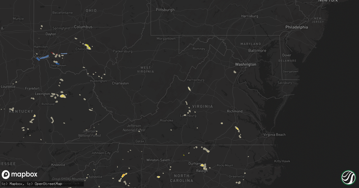
Hail Map in Virginia on July 6, 2022
Get this storm
July 6 map
$229
one time, instant access
Download today. No call, no setup
Keep the $229
Bought the map and want the full workflow? Apply the entire $229 to a subscription within 7 days. None of it is wasted.
Every map, not just this one
This buys you this map. Subscription and you get every map we run, in the markets you choose from a few cities to whole states to nationwide. Plus real-time alerts the moment a storm fires.
Contact data
Name, contact info, occupancy, even credit band for addresses in the footprint. You go from where it hit to who to call.
Become the source they trust
Unlimited branding weather history reports on demand. You already have the documented answer ready for the property owner, and you are the one who showed up with it.
Property data and RoofTrace estimates
Pull up any address you have got, its value and the exact code rules for that jurisdiction, straight from One Click Code. Then RoofTrace estimates the squares, pitch, and roof value, priced the way you price.
Storm reports in Virginia
Virginia
| Date | Description |
|---|---|
| 07/06/20226:58 PM CDT | Trees down on river road. Time estimated by radar. |
| 07/06/20226:37 PM CDT | Correction of report source to public. Thunderstorm winds blew the top three feet of a healthy sycamore tree down along a pond between johns creek and the 17300 block o |
| 07/06/20226:25 PM CDT | Couple of trees down in saxe. |
| 07/06/20226:24 PM CDT | Thunderstorm winds blew down one tree along paint bank road close to the paint bank general store. |
| 07/06/20226:09 PM CDT | Several trees down in charlotte courthouse. |
| 07/06/20226:05 PM CDT | Two trees down on south lee highway near high bridge church road. |
| 07/06/20225:56 PM CDT | Trees down on cub creek church road. Time estimated by radar. |
| 07/06/20225:54 PM CDT | Trees down on scuffletown road. Time estimated by radar. |
| 07/06/20225:49 PM CDT | Numerous trees down across the county. Vdot and law enforcement working several road closures due to downed trees. |
| 07/06/20225:45 PM CDT | Numerous trees down in phenix. |
| 07/06/20225:43 PM CDT | Trees down route 607 near old courthouse rd. |
| 07/06/20225:43 PM CDT | Trees down on burkeville rd. |
| 07/06/20225:41 PM CDT | Trees down on route 609 near capron. |
| 07/06/20225:30 PM CDT | Wires down. |
| 07/06/20225:30 PM CDT | Trees down on route 628 near burkeville. |
| 07/06/20225:26 PM CDT | Trees and power lines down. |
| 07/06/20225:25 PM CDT | Tree down. Time estimated. |
| 07/06/20225:20 PM CDT | Wires down. Time estimated. |
| 07/06/20225:15 PM CDT | Tree down. Time estimated. |
| 07/06/20225:10 PM CDT | Tree down. Time estimated. |
| 07/06/20225:10 PM CDT | Tree down. Time estimated. |
| 07/06/20225:05 PM CDT | Trees down. |
| 07/06/20225:05 PM CDT | Trees down partially blocking route 45. |
| 07/06/20225:05 PM CDT | Trees down. |
| 07/06/20225:05 PM CDT | Wire down. |
| 07/06/20225:00 PM CDT | Multiple power outages reported. |
| 07/06/20225:00 PM CDT | Tree down along prince edward hwy in farmville... Va. Time estimated. |
| 07/06/20224:56 PM CDT | Tree down on roadway. |
| 07/06/20224:55 PM CDT | Multiple trees down along north creek road and oakville road. |
| 07/06/20224:47 PM CDT | Trees down along route 40. |
| 07/06/20224:44 PM CDT | Tree down on paradise road. |
| 07/06/20224:42 PM CDT | Tree down on bent creek road. |
| 07/06/20224:41 PM CDT | Tree down along spring grove road. |
| 07/06/20224:34 PM CDT | Several trees down across southern portions of buckingham county in the toga area. |
| 07/06/20224:25 PM CDT | Tree down. Time estimated. |
| 07/06/20224:20 PM CDT | Numerous power outages and trees down in southern prince george along route 35. |
| 07/06/20224:00 PM CDT | Corrects previous tstm wnd dmg report from 2 se marion. Corrects previous tstm wnd dmg report from 1 se marion. Trees down on highway 16 outside marion. |
| 07/06/20223:55 PM CDT | Corrects previous tstm wnd dmg report from 1 se marion. Trees down on highway 16 outside marion. |
| 07/06/20223:55 PM CDT | Trees down on highway 16 outside marion. |
| 07/06/20223:55 PM CDT | Several trees down on highway 60 west. |
| 07/06/20223:30 PM CDT | Corrects previous non-tstm wnd dmg report from 2 wsw fairfield. Several trees down along the interstate. |
| 07/06/20223:30 PM CDT | Tree down on lyndhurst road. |
| 07/06/20223:27 PM CDT | Several reports of trees down across eastern augusta county. |
| 07/06/20223:16 PM CDT | Several large limbs down along clearfork road. |
| 07/06/20223:09 PM CDT | Multiple trees down in 100 block of first street. |
| 07/06/20223:06 PM CDT | Several reports of trees down throughout the city of staunton. |
| 07/06/20223:02 PM CDT | Multiple trees down and power lines down on aiken street in staunton. |
| 07/06/20222:59 PM CDT | Tree down on a car on devon road. |
| 07/06/20222:51 PM CDT | Tree down on a car on churchville avenue near intersection with eastwood drive. |
| 07/06/20222:49 PM CDT | Siding torn off the side of a home in churchville. |
| 07/06/20222:06 PM CDT | Multiple trees down in the pound area. |
| 07/06/20222:01 PM CDT | Thunderstorm winds blew down seven trees along 20th street ne. |
| 07/06/20223:10 AM CDT | At 809 PM EDT, severe thunderstorms were located along a line extending from near Clarksville to near Cluster Springs, moving southeast at 25 mph. In addition, an outflow boundary surging southward well ahead of the storms is producing wind gusts of up to 40 mph. HAZARD...60 mph wind gusts. SOURCE...Radar indicated. IMPACT...Expect damage to roofs, siding, and trees. Locations impacted include... Henderson, Oxford, Roxboro, Warrenton, Norlina, Concord, Stovall, Middleburg, Mayo Reservoir and Steele Creek Marina & Campground. |
| 07/06/20222:53 AM CDT | At 753 PM EDT, severe thunderstorms were located along a line extending from Ehkhorn Mine to Hallie, moving southeast at 25 mph. HAZARD...60 mph wind gusts and nickel size hail. SOURCE...Radar indicated. IMPACT...Expect damage to roofs, siding, and trees. Severe thunderstorms will be near... Fleming-Neon around 800 PM EDT. Jenkins around 805 PM EDT. Burdine around 810 PM EDT.Other locations in the path of these severe thunderstorms include Dayand Oven Fork. |
| 07/06/20222:46 AM CDT | At 746 PM EDT, a severe thunderstorm was located over New Castle, moving southeast at 15 mph. HAZARD...60 mph wind gusts and quarter size hail. SOURCE...Radar indicated. IMPACT...Hail damage to vehicles is expected. Expect wind damage to roofs, siding, and trees. Locations impacted include... Roanoke... Salem... Vinton... Troutville... New Castle... Stewartsville... and Montvale.This includes The following Locations The Salem Fairgrounds andRoanoke Regional Airport. |
| 07/06/20222:27 AM CDT | At 727 PM EDT, a severe thunderstorm was located over Saxe, or 8 miles northeast of Clover, moving southeast at 20 mph. HAZARD...60 mph wind gusts. SOURCE...Radar indicated. IMPACT...Expect damage to roofs, siding, and trees. Locations impacted include... Charlotte Court House... Redoak... Clover... Drakes Branch... Mt Laurel... Wylliesburg... and Saxe. |
| 07/06/20222:20 AM CDT | At 720 PM EDT, a severe thunderstorm was located over Paint Bank, moving southeast at 20 mph. HAZARD...60 mph wind gusts and quarter size hail. SOURCE...Radar indicated. IMPACT...Hail damage to vehicles is expected. Expect wind damage to roofs, siding, and trees. Locations impacted include... New Castle... Paint Bank... Sinking Creek... Abbott... Sweet Springs... Craig Springs... and Moncove Lake State Park. |
| 07/06/20222:18 AM CDT | At 718 PM EDT, a severe thunderstorm was located over Leda, or near Mt Airy, moving southeast at 10 mph. HAZARD...60 mph wind gusts and quarter size hail. SOURCE...Radar indicated. IMPACT...Hail damage to vehicles is expected. Expect wind damage to roofs, siding, and trees. Locations impacted include... South Boston... Halifax... Nathalie... Mt Laurel... Cody... Leda... and Crystal Hill. |
| 07/06/20221:44 AM CDT | At 644 PM EDT, severe thunderstorms were located along a line extending from near Spainville to near Blackstone to near Kenbridge, moving southeast at 45 mph. HAZARD...60 mph wind gusts. SOURCE...Radar indicated. IMPACT...Expect damage to trees and powerlines. Severe thunderstorms will be near... Fort Pickett around 650 PM EDT. Wilsons around 655 PM EDT. Dundas around 700 PM EDT. McKenney around 705 PM EDT. Alberta around 710 PM EDT. Dinwiddie, Lawrenceville and Dewitt around 715 PM EDT. Purdy around 725 PM EDT. Jarratt, Stony Creek and Radium around 730 PM EDT.Other locations impacted by these severe thunderstorms include NorthWellville, Cochran, Irby, Gills Corner, Bufford Crossroads, Dolphin,Earls, Murdocks, Pleasant Shade and Forkland. |
| 07/06/20221:42 AM CDT | At 642 PM EDT, a severe thunderstorm was located near Glen Wilton, or near Covington, moving southeast at 25 mph. HAZARD...60 mph wind gusts and quarter size hail. SOURCE...Radar indicated. IMPACT...Hail damage to vehicles is expected. Expect wind damage to roofs, siding, and trees. Locations impacted include... Covington... Clifton Forge... Buchanan... Eagle Rock... Iron Gate... Low Moor... and Springwood. |
| 07/06/20221:34 AM CDT | At 634 PM EDT, a severe thunderstorm was located over Phenix, moving southeast at 10 mph. HAZARD...60 mph wind gusts and quarter size hail. SOURCE...Radar indicated. IMPACT...Hail damage to vehicles is expected. Expect wind damage to roofs, siding, and trees. Locations impacted include... Keysville... Charlotte Court House... Phenix... Drakes Branch... Cullen... Saxe... and Aspen. |
| 07/06/20221:06 AM CDT | At 605 PM EDT, severe thunderstorms were located along a line extending from Cumberland to near Rice to near Abilene, moving southeast at 45 mph. An additional isolated storm has also developed out ahead of the line across northeastern Nottoway County. HAZARD...60 mph wind gusts and quarter size hail. SOURCE...Radar indicated. IMPACT...Minor damage to vehicles is possible. Expect wind damage to trees and powerlines. Severe thunderstorms will be near... Rice around 610 PM EDT. Burkeville and Sunnyside around 615 PM EDT. Crewe, Morven and Jetersville around 620 PM EDT. Green Bay around 625 PM EDT. Amelia Courthouse and Nottoway around 630 PM EDT. Blackstone, Victoria, Spainville, Scotts Fork and Chula around 635 PM EDT. Kenbridge, Wilsons and Fort Pickett around 640 PM EDT. Mannboro and Dundas around 645 PM EDT.Other locations impacted by these severe thunderstorms include NorthWellville, Angola, Ammon, Murdocks, Nutbush, Wellville, BlackstoneAirport, Denaro, Rawlings and Barrows Store. |
| 07/06/202212:42 AM CDT | At 542 PM EDT, a severe thunderstorm was located near Sussex, or 10 miles southwest of Waverly, moving southeast at 20 mph. HAZARD...60 mph wind gusts and quarter size hail. SOURCE...Radar indicated. IMPACT...Minor damage to vehicles is possible. Expect wind damage to trees and powerlines. This severe thunderstorm will be near... Homeville around 550 PM EDT. Courtland and Sedley around 630 PM EDT.Other locations impacted by this severe thunderstorm includeVicksville, Dory, Berlin, Booker, Yale, Lumberton, Sebrell, Manry,Joyner and Worrell. |
| 07/06/202212:35 AM CDT | At 534 PM EDT, severe thunderstorms were located along a line extending from near Centenary to near Toga to near Spring Mills, moving southeast at 30 mph. HAZARD...60 mph wind gusts and penny size hail. SOURCE...Radar indicated. IMPACT...Expect damage to trees and powerlines. Severe thunderstorms will be near... Prospect around 600 PM EDT. Farmville and Darlington Heights around 605 PM EDT. Hampden Sydney and Guinea Mills around 610 PM EDT. Cumberland, Hampden Sydney College and Longwood University around 615 PM EDT. Rice around 625 PM EDT. Green Bay around 630 PM EDT.Other locations impacted by these severe thunderstorms include RainesTavern, Briery Creek Lake, Trents Mill, Tuggle, Prince EdwardStation, Angola, Briery, Twin Lakes State Park, Allens Mill andMcRae. |
| 07/06/202212:11 AM CDT | At 511 PM EDT, severe thunderstorms were located along a line extending from near Schuyler to near Wingina to near Riverville to Bocock, moving east at 35 mph. HAZARD...60 mph wind gusts and quarter size hail. SOURCE...Radar indicated. IMPACT...Hail damage to vehicles is expected. Expect wind damage to roofs, siding, and trees. Locations impacted include... Buckingham... Appomattox... Dillwyn... Bent Creek... Concord... Rustburg... and Pamplin City. |
| 07/06/202212:01 AM CDT | At 500 PM EDT, severe thunderstorms were located along a line extending from 6 miles north of Schuyler to near Shipman, moving southeast at 25 mph. HAZARD...60 mph wind gusts. SOURCE...Radar indicated. IMPACT...Damaging winds will cause some trees and large branches to fall. This could injure those outdoors, as well as damage homes and vehicles. Roadways may become blocked by downed trees. Localized power outages are possible. Unsecured light objects may become projectiles. Locations impacted include... Shipman, Schuyler, Arrington, Scottsville, Esmont, Lovingston, Tye River, Damon, Allens Creek, Covesville, Rockfish, Buffalo Springs, Norwood, Glendower, Keene, Five Forks, Alberene, Wingina, Gladstone and Elma. |
| 07/06/202212:00 AM CDT | At 500 PM EDT, a severe thunderstorm was located near Petersburg, moving southeast at 20 mph. HAZARD...60 mph wind gusts. SOURCE...Radar indicated. IMPACT...Expect damage to trees and powerlines. This severe thunderstorm will be near... Carson around 510 PM EDT. Disputanta around 525 PM EDT.Other locations impacted by this severe thunderstorm includeNewville, Richard Bland College, Burgess, Templeton, Booker, Reamsand Prince George Golf. |
| 07/05/202211:49 PM CDT | At 449 PM EDT, severe thunderstorms were located along a line extending from near Lowesville to near Naola to near Coleman Falls, moving southeast at 15 mph. HAZARD...60 mph wind gusts and quarter size hail. SOURCE...Radar indicated. IMPACT...Hail damage to vehicles is expected. Expect wind damage to roofs, siding, and trees. Locations impacted include... Lynchburg... Amherst... Forks Of Buffalo... Big Island... Bent Creek... Concord... and Clifford.This includes The following Locations Liberty University andLynchburg Airport. |
| 07/05/202211:40 PM CDT | There was about half a dozen reports of trees blown down between hoadley and bethel. |
| 07/05/202211:35 PM CDT | Several trees... Wires... And poles blew down near the intersection of va-642 hoadly road and purcell road. |
| 07/05/202211:22 PM CDT | At 422 PM EDT, a severe thunderstorm was located over Alto, or near Forks Of Buffalo, moving southeast at 20 mph. HAZARD...60 mph wind gusts and quarter size hail. SOURCE...Radar indicated. IMPACT...Hail damage to vehicles is expected. Expect wind damage to roofs, siding, and trees. Locations impacted include... Buena Vista... Amherst... Forks Of Buffalo... Clifford... Pleasant View... Falconerville... and Riverville. |
| 07/05/202211:17 PM CDT | At 416 PM EDT, a severe thunderstorm was located over Alto, or 7 miles north of Forks Of Buffalo, moving southeast at 25 mph. HAZARD...60 mph wind gusts and quarter size hail. SOURCE...Radar indicated. IMPACT...Damaging winds will cause some trees and large branches to fall. This could injure those outdoors, as well as damage homes and vehicles. Roadways may become blocked by downed trees. Localized power outages are possible. Unsecured light objects may become projectiles. Locations impacted include... Montebello, Arrington, Norwood, Five Forks, Tye River, Jonesboro, Allens Creek, Gladstone, Roseland, Buffalo Springs and Massies Mill. |
| 07/05/202211:08 PM CDT | At 408 PM EDT, a severe thunderstorm was located near Gratton, or near Burkes Garden, moving east at 15 mph. HAZARD...60 mph wind gusts and quarter size hail. SOURCE...Radar indicated. IMPACT...Hail damage to vehicles is expected. Expect wind damage to roofs, siding, and trees. Locations impacted include... Wytheville... Bland... Tazewell... Ceres... Bastian... Burkes Garden... and Gratton. |
| 07/05/202211:06 PM CDT | At 406 PM EDT, a severe thunderstorm was located over Fairfield, or 8 miles east of Rockbridge Baths, moving southeast at 15 mph. HAZARD...60 mph wind gusts and quarter size hail. SOURCE...Radar indicated. IMPACT...Hail damage to vehicles is expected. Expect wind damage to roofs, siding, and trees. Locations impacted include... Rockbridge Baths... Cornwall... Alto... Fairfield... Oronoco... Brownsburg... and Vesuvius. |
| 07/05/202211:06 PM CDT | At 405 PM EDT, a severe thunderstorm was located over Staunton, moving southeast at 20 mph. HAZARD...60 mph wind gusts and quarter size hail. SOURCE...Radar indicated. IMPACT...Damaging winds will cause some trees and large branches to fall. This could injure those outdoors, as well as damage homes and vehicles. Roadways may become blocked by downed trees. Localized power outages are possible. Unsecured light objects may become projectiles. Locations impacted include... Staunton, Waynesboro, Stuarts Draft, Sherando, Wintergreen, Afton, Fishersville, Lyndhurst, Nellysford, Hermitage, Batesville, Mint Spring and Afton Mountain. |
| 07/05/202210:46 PM CDT | At 346 PM EDT, a severe thunderstorm was located 7 miles northwest of Staunton, moving southeast at 15 mph. HAZARD...60 mph wind gusts and quarter size hail. SOURCE...Radar indicated. IMPACT...Damaging winds will cause some trees and large branches to fall. This could injure those outdoors, as well as damage homes and vehicles. Roadways may become blocked by downed trees. Localized power outages are possible. Unsecured light objects may become projectiles. Locations impacted include... Staunton, Verona, New Hope, Mount Sidney, Churchville and Fort Defiance. |
| 07/05/20229:41 PM CDT | At 241 PM EDT, a severe thunderstorm was located near Payne Gap, or 7 miles north of Wise, moving east at 20 mph. HAZARD...60 mph wind gusts and penny size hail. SOURCE...Radar indicated. IMPACT...Expect damage to roofs, siding, and trees. Locations impacted include... Norton, Wise, Coeburn, Pound and Pardee. |
| 07/05/20227:11 PM CDT | Multiple trees and power lines down due to thunderstorm winds in the cluster springs area of halifax county. |
| 07/05/20227:10 PM CDT | Power lines down east of chase city. |
| 07/05/20227:05 PM CDT | Thunderstorm winds blew down one tree at the intersection of glebe road and orchard lake drive. |
| 07/05/20227:00 PM CDT | Trees down along berry hill road. Time estimated by radar. |
All States Impacted by Hail Map on July 6, 2022
Cities Impacted by Hail Map on July 6, 2022
- Joplin, MT
- Chinook, MT
- Lavina, MT
- Roundup, MT
- Bowman, ND
- Frazer, MT
- Poplar, MT
- Avon, MT
- Hobson, MT
- Buffalo, MT
- Forsyth, MT
- Loma, MT
- Chester, MT
- Ledger, MT
- Fort Benton, MT
- Big Sandy, MT
- Inverness, MT
- Glendive, MT
- Lindsay, MT
- Terry, MT
- Brusett, MT
- Geyser, MT
- Grass Range, MT
- Elkfork, KY
- Sandy Hook, KY
- Axtell, KS
- Corning, KS
- Clearmont, MO
- Greensburg, IN
- Havensville, KS
- Mitchell, OR
- Lame Deer, MT
- Birney, MT
- Glendale, KY
- Cecilia, KY
- Martin, KY
- Banner, KY
- Allen, KY
- Prestonsburg, KY
- Dana, KY
- Apple Grove, WV
- Gallipolis Ferry, WV
- Hamptonville, NC
- Hartford, KY
- Akron, CO
- Max Meadows, VA
- Piedmont, SC
- Pelzer, SC
- Williamston, SC
- Booker, TX
- Perryton, TX
- Balko, OK
- Hettinger, ND
- Mott, ND
- New Leipzig, ND
- New Raymer, CO
- Grover, CO
- Havre, MT
- Kremlin, MT
- Rudyard, MT
- Hingham, MT
- Ryegate, MT
- Stanford, MT
- Shepherd, MT
- Huntley, MT
- Fairmont, NE
- Box Elder, MT
- Cheyenne Wells, CO
- Glenarm, IL
- Chatham, IL
- Hogeland, MT
- Harlem, MT
- Elizabeth, IN
- Towner, ND
- Rugby, ND
- Gillette, WY
- Haddam, KS
- Egnar, CO
- Othello, WA
- Batavia, OH
- Pleasant Plain, OH
- Blanchester, OH
- Goshen, OH
- Rocky Ford, CO
- Manzanola, CO
- Vida, MT
- Richey, MT
- Wolf Point, MT
- Limon, CO
- Matheson, CO
- Jordan, MT
- Cohagen, MT
- Powell, WY
- White Sulphur Springs, MT
- Winnett, MT
- Prineville, OR
- Goff, KS
- Atchison, KS
- Bethune, CO
- Narka, KS
- Culbertson, MT
- Lancaster, MN
- Musselshell, MT
- Gordon, NE
- Rushville, NE
- Malta, MT
- Zortman, MT
- Hays, MT
- Dodson, MT
- Lloyd, MT
- Jefferson City, MT
- Clancy, MT
- Boulder, MT
- Belfield, ND
- Crowley, CO
- Ordway, CO
- Olney Springs, CO
- Fallon, MT
- Hardy, NE
- Fairbury, NE
- Lewistown, MT
- Ingomar, MT
- Sand Springs, MT
- La Junta, CO
- Union Point, GA
- Blue Hill, NE
- Hurdle Mills, NC
- Owingsville, KY
- Mount Sterling, KY
- Frenchburg, KY
- Olympia, KY
- Means, KY
- Hope, KY
- Jeffersonville, KY
- Thompsonville, IL
- Ware Shoals, SC
- Laurens, SC
- McIntosh, SD
- Fort Peck, MT
- Amidon, ND
- Deaver, WY
- Marion, MT
- Raynesford, MT
- Belt, MT
- Morrisonville, IL
- Pawnee, IL
- Lead, SD
- Helmville, MT
- Willow Wood, OH
- Scottown, OH
- Chesapeake, OH
- Merino, CO
- Kila, MT
- Townsend, MT
- Bighorn, MT
- Verdon, NE
- Sebree, KY
- Ellis, KS
- Salt Lick, KY
- Williamsburg, OH
- Bethel, OH
- Georgetown, OH
- Hamersville, OH
- Mount Orab, OH
- Ramah, CO
- Calhan, CO
- Minneola, KS
- Kit Carson, CO
- Franktown, CO
- Castle Rock, CO
- Elbert, CO
- Bridger, MT
- Buffalo, WY
- Kaycee, WY
- Jetmore, KS
- Rineyville, KY
- Watauga, SD
- Selfridge, ND
- Morristown, SD
- Wray, CO
- Williamsport, OH
- Lawson, MO
- Springfield, OH
- South Charleston, OH
- Hinsdale, MT
- Geraldine, MT
- Whiting, KS
- Netawaka, KS
- Horton, KS
- Custer, SD
- Nezperce, ID
- Ferdinand, ID
- New England, ND
- South Heart, ND
- Lathrop, MO
- Turney, MO
- Keystone, SD
- Hermosa, SD
- Wetmore, KS
- Londonderry, OH
- Chillicothe, OH
- Laurelville, OH
- Kingston, OH
- Seneca, KS
- Wathena, KS
- Saint Joseph, MO
- Fort Morgan, CO
- Basin, MT
- Hot Springs, MT
- Plains, MT
- Brockton, MT
- Froid, MT
- Moore, MT
- Moccasin, MT
- Forest Grove, MT
- Craigmont, ID
- Lewiston, ID
- Imnaha, OR
- Enterprise, OR
- Cottonwood, ID
- Elizabethtown, IN
- Ewing, KY
- Mullinville, KS
- Randleman, NC
- Pleasant Garden, NC
- Andersonville, TN
- Heiskell, TN
- Strunk, KY
- Corydon, IN
- Winnsboro, SC
- Winchester, KY
- Inman, SC
- Campobello, SC
- Monroe, NC
- Brockway, MT
- Russell Springs, KY
- Glens Fork, KY
- Columbia, KY
- Ruskin, FL
- Flagler, CO
- Vona, CO
- Sunnyside, WA
- Grandview, WA
- Prosser, WA
- Mabton, WA
- Toppenish, WA
- Plattsburg, MO
- Blackstone, VA
- Seibert, CO
- South Bloomingville, OH
- Glenwood, MO
- Lancaster, MO
- Coatsville, MO
- Larkspur, CO
- Sedalia, CO
- Fayetteville, OH
- Spray, OR
- Belleville, KS
- Munden, KS
- Washington, KS
- Denton, NC
- Trinity, NC
- Lexington, NC
- Rush Center, KS
- Larned, KS
- Henderson, NE
- Sutton, NE
- Grafton, NE
- McCool Junction, NE
- Rozel, KS
- Shubert, NE
- Everest, KS
- Robinson, KS
- Kiowa, CO
- Bennett, CO
- Elizabeth, CO
- Red Cloud, NE
- Albany, KY
- Butlerville, IN
- Manchester, KY
- Bessemer City, NC
- Kings Mountain, NC
- Gurley, AL
- Procious, WV
- Sweetwater, TN
- Athens, TN
- Equality, IL
- Canon, GA
- Murphy, NC
- Waynesville, NC
- Hodgenville, KY
- New Hope, KY
- New Haven, KY
- Bowman, GA
- Royston, GA
- Central, SC
- Lutts, TN
- Sunbright, TN
- East Bernstadt, KY
- Livingston, KY
- Hillsboro, OH
- Lynchburg, OH
- Ayden, NC
- Ringgold, GA
- Laurel Springs, NC
- Pendleton, SC
- Fountain Inn, SC
- Simpsonville, SC
- Abilene, KS
- Spartanburg, SC
- Wellford, SC
- Hanston, KS
- Kinsley, KS
- Tell City, IN
- Ellinwood, KS
- Great Bend, KS
- Lilburn, GA
- Trimble, MO
- Scranton, SC
- Timmonsville, SC
- Olanta, SC
- Tellico Plains, TN
- Lamar, SC
- Matthews, NC
- Waxhaw, NC
- Indian Trail, NC
- Charlotte, NC
- Pacolet, SC
- Bowersville, GA
- Lavonia, GA
- Hartwell, GA
- Clifton Hill, MO
- Huntsville, MO
- Martin, GA
- Carnesville, GA
- Lewisburg, OH
- Linn, KS
- Rockwood, TN
- Maryville, MO
- Pickering, MO
- Strasburg, CO
- Morrowville, KS
- Peyton, CO
- Minneapolis, KS
- Greenville, SC
- Ford, KS
- Spearville, KS
- Hoisington, KS
- Albert, KS
- Olmitz, KS
- McCracken, KS
- Bison, KS
- Otis, KS
- La Crosse, KS
- Crestwood, KY
- La Grange, KY
- Buckner, KY
- Pedro, OH
- Weston, CO
- Capron, VA
- Yale, VA
- Salisbury, NC
- Richfield, NC
- Danielsville, GA
- Wendell, NC
- Raleigh, NC
- Wake Forest, NC
- Knightdale, NC
- Gable, SC
- Alcolu, SC
- New Zion, SC
- Stephens, GA
- Eatonton, GA
- Madison, GA
- Washington Court House, OH
- New Holland, OH
- Mount Sterling, OH
- Casar, NC
- Gladstone, VA
- Appomattox, VA
- Tribune, KS
- Holly, CO
- Marshall, NC
- Tazewell, TN
- Rainsville, AL
- Watertown, TN
- Milton, TN
- Dunn, NC
- Niota, TN
- Elloree, SC
- Santee, SC
- Clyde, NC
- Canton, NC
- Reevesville, SC
- Saint George, SC
- Inavale, NE
- Big Clifty, KY
- Thorn Hill, TN
- Mooresburg, TN
- Bean Station, TN
- Waverly, VA
- Petersburg, VA
- Carson, VA
- Stony Creek, VA
- Disputanta, VA
- Miami, TX
- Rosston, OK
- Rock Hill, SC
- Fort Mill, SC
- Lancaster, SC
- Hickory, NC
- Morganton, NC
- Connelly Springs, NC
- Vale, NC
- Hildebran, NC
- Oxford, NC
- Bullock, NC
- Henderson, NC
- State Road, NC
- Wise, VA
- Coeburn, VA
- Taylorsville, NC
- Ten Mile, TN
- Buckhead, GA
- Philadelphia, TN
- Idalia, CO
- Brownell, KS
- Arcanum, OH
- Jamesport, MO
- Chillicothe, MO
- Stewartsville, MO
- Briggsdale, CO
- Fairfield, NE
- Glenvil, NE
- Fairfax, MO
- Leitchfield, KY
- Flatgap, KY
- Oil Springs, KY
- West Liberty, KY
- Ironton, OH
- Baileyville, KS
- Centralia, KS
- Frankfort, KS
- Vermillion, KS
- Cleveland, TN
- McBee, SC
- Sardinia, OH
- Laverne, OK
- Partridge, KY
- Cumberland, KY
- Clay City, KY
- Irvine, KY
- Clintwood, VA
- Franklin, NC
- Shelby, NC
- Cherryville, NC
- Lawndale, NC
- Good Hope, GA
- Mountville, SC
- Apollo Beach, FL
- Soldier, KS
- Cedar Bluff, AL
- Gaylesville, AL
- Clifton, KS
- Cuba, KS
- Agenda, KS
- Karval, CO
- Simla, CO
- Hugo, CO
- Wild Horse, CO
- Effingham, KS
- Muscotah, KS
- Flemingsburg, KY
- Mayslick, KY
- Clendenin, WV
- Oakdale, TN
- Ashland, KS
- Leopold, IN
- Knoxville, TN
- Nebo, NC
- Belton, SC
- Etowah, TN
- Reliance, TN
- Toccoa, GA
- Westminster, SC
- Saint Matthews, SC
- Swansea, SC
- Turbeville, SC
- Lake City, SC
- Lyman, SC
- Bowman, SC
- Ridgeway, SC
- Jonesville, SC
- Lenoir, NC
- Englewood, TN
- Sumter, SC
- Manning, SC
- Liberty, KY
- Dunnville, KY
- Yosemite, KY
- Luttrell, TN
- Maynardville, TN
- Ruffin, SC
- Borger, TX
- Hollywood, AL
- Scottsboro, AL
- Fackler, AL
- Gainesville, GA
- Society Hill, SC
- Burlington, CO
- Syracuse, KS
- Guilford, MO
- Portsmouth, OH
- McDermott, OH
- Churchville, VA
- Staunton, VA
- Vesuvius, VA
- Hustonville, KY
- Amherst, VA
- Lynchburg, VA
- Forest, VA
- Pound, VA
- Beaver Dam, KY
- Centertown, KY
- Sumerco, WV
- Julian, WV
- Sugar City, CO
- Gaffney, SC
- Jefferson, NC
- Millers Creek, NC
- Landrum, SC
- Anderson, SC
- Eastanollee, GA
- Chocowinity, NC
- Sheridan Lake, CO
- Fraziers Bottom, WV
- Buffalo, WV
- Proctorville, OH
- Offerle, KS
- Clarkson, KY
- Camden, OH
- Vanceboro, NC
- Grimesland, NC
- Greenville, NC
- Lyons, KS
- Crouse, NC
- Smithville, MO
- Saluda, NC
- Columbus, NC
- Tryon, NC
- Rogersville, TN
- Falls City, NE
- Kirk, CO
- Kenna, WV
- Charleston, WV
- Given, WV
- Advent, WV
- Liberty, WV
- Harrodsburg, KY
- Salvisa, KY
- Salley, SC
- Wagener, SC
- Nokesville, VA
- Manassas, VA
- Woodbridge, VA
- Sparta, GA
- Lancing, TN
- Duluth, GA
- Suwanee, GA
- Cimarron, KS
- Greer, SC
- Phenix, VA
- Summerton, SC
- Stearns, KY
- Varnville, SC
- Bazine, KS
- Cross Plains, IN
- Canaan, IN
- Madison, IN
- Bennington, IN
- Versailles, IN
- Liebenthal, KS
- Madison Heights, VA
- Monroe, VA
- Lancaster, KS
- Denton, KS
- McDonald, TN
- Ooltewah, TN
- Raymond, KS
- Wakeeney, KS
- Chase, KS
- Hudson, KS
- St John, KS
- Alexander, KS
- Claflin, KS
- Pawnee Rock, KS
- Boiling Springs, SC
- Caryville, TN
- Franklin, TN
- Corryton, TN
- Kersey, CO
- Orchard, CO
- Weldona, CO
- Gill, CO
- Log Lane Village, CO
- Brush, CO
- Blue Rapids, KS
- Randolph, KS
- Lebanon, KS
- Troy, KS
- Bendena, KS
- Galatia, IL
- Carrier Mills, IL
- East Flat Rock, NC
- Hendersonville, NC
- Flat Rock, NC
- Collinwood, TN
- Eastview, KY
- Gray, GA
- La Fayette, GA
- Leicester, NC
- Townville, SC
- Oliver Springs, TN
- Oak Ridge, TN
- Osborn, MO
- Cameron, MO
- Palouse, WA
- Garfield, WA
- Onaga, KS
- Knightstown, IN
- Oregon, MO
- Forest City, MO
- Maitland, MO
- North Vernon, IN
- Smith Center, KS
- Westport, IN
- Fair Play, SC
- Monticello, KY
- Colerain, NC
- Vance, SC
- Rock Spring, GA
- Honea Path, SC
- Fritch, TX
- Agency, MO
- Easton, MO
- Ellenboro, NC
- Amazonia, MO
- Agate, CO
- Clinton, SC
- Godwin, NC
- Jamestown, KY
- Dry Branch, GA
- Canyon, TX
- Winfield, WV
- Hurricane, WV
- Milton, WV
- Glenwood, WV
- Williamston, NC
- Washington, NC
- Ocala, FL
- Una, SC
- Linden, TN
- Grandview, TN
- Andrews, NC
- Holt, MO
- Elkview, WV
- Walton, WV
- Prospect, KY
- Franklin Furnace, OH
- Sharpsburg, KY
- Moorefield, KY
- Mauldin, SC
- Deer Lodge, TN
- Zebulon, NC
- Islandton, SC
- Saint Albans, WV
- Nitro, WV
- Dunbar, WV
- Scott Depot, WV
- Cleves, OH
- Highland, KS
- Versailles, KY
- Kingston, TN
- Clarksdale, MO
- Helena, MO
- Cosby, MO
- Amity, MO
- Union Star, MO
- Courtland, KS
- Republic, KS
- Scandia, KS
- Crown City, OH
- Wytheville, VA
- Middleburg, KY
- Spring City, TN
- Roxboro, NC
- Social Circle, GA
- Rocky Mount, VA
- Glade Hill, VA
- Branchville, SC
- Lake Bronson, MN
- Outlook, WA
- Glasgow, MT
- Victor, MT
- Byers, CO
- Snyder, CO
- Galeton, CO
- Eaton, CO
- Yuma, CO
- Las Animas, CO
- Lamar, CO
- Lovell, WY
- Fairview, MT
- Nashua, MT
- Hardin, MT
- Crow Agency, MT
- Worden, MT
- Shelby, MT
- Highwood, MT
- Circle, MT
- Lincoln, KS
- Beverly, KS
- Sunman, IN
- Milan, IN
- Osgood, IN
- Moores Hill, IN
- Hebron, KY
- Burlington, KY
- Erlanger, KY
- Florence, KY
- Bellevue, KY
- Ft Mitchell, KY
- Latonia, KY
- Fort Thomas, KY
- Newport, KY
- Cincinnati, OH
- Covington, KY
- Terrace Park, OH
- Milford, OH


