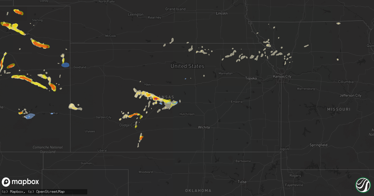
Hail Map in Kansas on July 6, 2022
Get this storm
July 6 map
$229
one time, instant access
Download today. No call, no setup
Keep the $229
Bought the map and want the full workflow? Apply the entire $229 to a subscription within 7 days. None of it is wasted.
Every map, not just this one
This buys you this map. Subscription and you get every map we run, in the markets you choose from a few cities to whole states to nationwide. Plus real-time alerts the moment a storm fires.
Contact data
Name, contact info, occupancy, even credit band for addresses in the footprint. You go from where it hit to who to call.
Become the source they trust
Unlimited branding weather history reports on demand. You already have the documented answer ready for the property owner, and you are the one who showed up with it.
Property data and RoofTrace estimates
Pull up any address you have got, its value and the exact code rules for that jurisdiction, straight from One Click Code. Then RoofTrace estimates the squares, pitch, and roof value, priced the way you price.
Storm reports in Kansas
Kansas
| Date | Description |
|---|---|
| 07/06/20226:59 PM CDT | Mesonet station qnrk1 stafford. |
| 07/06/20226:55 PM CDT | Spotter also reported pea sized hail. |
| 07/06/20226:26 PM CDT | Spotter reported 1 inch hail along with a large tree limb that fell. |
| 07/06/20226:26 PM CDT | Spotter estimated quarter sized hail and reported a large tree limb that was down from strong winds. |
| 07/06/20226:25 PM CDT | Law enforcement reported powerlines snapped with lots of debris and large tree limbs down. |
| 07/06/20226:25 PM CDT | Corrects previous tstm wnd dmg report from ellinwood. An observer found multiple 6 to 8 inch tree limbs down and estimated 70 to 80 mph winds. |
| 07/06/20225:48 PM CDT | Awos station kgbd great bend municipal airpt. |
| 07/06/20225:29 PM CDT | A local report indicates 60 MPH wind near GREAT BEND AIRPORT |
| 07/06/20225:24 PM CDT | Report made via nwschat. |
| 07/06/20225:19 PM CDT | Estimated size based on image and time based on radar. |
| 07/06/20225:11 PM CDT | Delayed report via social media and kwch. |
| 07/06/20224:33 PM CDT | Public report was posted on social media via broadcast media. |
| 07/06/20224:30 PM CDT | A local report indicates 1.75 inch wind near LA CROSSE |
| 07/06/20226:42 AM CDT | At 1141 PM CDT/1041 PM MDT/, severe thunderstorms were located along a line extending from 12 miles northeast of Hartman to 9 miles south of Holly to 7 miles north of Two Buttes, moving east at 20 mph. HAZARD...60 mph wind gusts. SOURCE...Radar indicated. IMPACT...Expect damage to roofs, siding, and trees. Severe thunderstorms will be near... Coolidge around 1055 PM MDT.Other locations in the path of these severe thunderstorms includeSyracuse. |
| 07/06/20226:17 AM CDT | At 1117 PM MDT, a severe thunderstorm was located 12 miles south of Towner, or 17 miles north of Coolidge, moving northeast at 30 mph. HAZARD...60 mph wind gusts and quarter size hail. SOURCE...Radar indicated. IMPACT...Hail damage to vehicles is expected. Expect wind damage to roofs, siding, and trees. This severe thunderstorm will remain over mainly rural areas of southwestern Greeley County. |
| 07/06/20223:58 AM CDT | At 858 PM CDT, a severe thunderstorm was located 4 miles north of Culver, moving northeast at 25 mph. HAZARD...60 mph wind gusts and penny size hail. SOURCE...Radar indicated. IMPACT...Expect damage to roofs, siding, and trees. Locations impacted include... Minneapolis, Bennington, Miltonvale, Delphos, Culver, Wells, Niles and Ada. |
| 07/06/20222:11 AM CDT | At 711 PM CDT, a severe thunderstorm was located near Lyons, moving east at 35 mph. HAZARD...70 mph wind gusts and half dollar size hail. SOURCE...Radar indicated. IMPACT...Hail damage to vehicles is expected. Expect considerable tree damage. Wind damage is also likely to mobile homes, roofs, and outbuildings. Locations impacted include... Lyons, Sterling, Little River, Chase, Geneseo, Alden and Frederick. |
| 07/06/20221:21 AM CDT | At 621 PM CDT, a severe thunderstorm was located near Ellinwood, moving east at 25 mph. HAZARD...Golf ball size hail and 70 mph wind gusts. SOURCE...Radar indicated. IMPACT...People and animals outdoors will be injured. Expect hail damage to roofs, siding, windows, and vehicles. Expect considerable tree damage. Wind damage is also likely to mobile homes, roofs, and outbuildings. Locations impacted include... Lyons, Sterling, Ellinwood, Chase, Alden, Raymond and Silica. |
| 07/06/202212:30 AM CDT | At 530 PM CDT, a severe thunderstorm was located near Great Bend, moving southeast at 25 mph. HAZARD...60 mph wind gusts and quarter size hail. SOURCE...Radar indicated. IMPACT...Hail damage to vehicles is expected. Expect wind damage to roofs, siding, and trees. Locations impacted include... Great Bend, Hoisington, Ellinwood, Claflin, Great Bend Airport and Cheyenne Bottoms. |
| 07/06/202212:15 AM CDT | At 515 PM CDT, a severe thunderstorm was located near Jetmore, moving northeast at 20 mph. HAZARD...Half dollar size hail. SOURCE...Radar indicated. IMPACT...Damage to vehicles is expected. This severe thunderstorm will be near... Jetmore around 535 PM CDT.Other locations in the path of this severe thunderstorm include Grayand Hanston. |
| 07/05/202211:59 PM CDT | At 459 PM CDT, a severe thunderstorm was located 10 miles southeast of Bucklin, moving northeast at 20 mph. HAZARD...Half dollar size hail. SOURCE...Radar indicated. IMPACT...Damage to vehicles is expected. Locations impacted include... Mullinville. |
| 07/05/202211:54 PM CDT | At 454 PM CDT, a severe thunderstorm was located near Bison, moving east at 15 mph. HAZARD...Ping pong ball size hail and 60 mph wind gusts. SOURCE...Radar indicated. IMPACT...People and animals outdoors will be injured. Expect hail damage to roofs, siding, windows, and vehicles. Expect wind damage to roofs, siding, and trees. Locations impacted include... Hoisington, Albert, Olmitz, Milberger, Galatia and Susank. |
| 07/05/202211:33 PM CDT | At 433 PM CDT, a severe thunderstorm was located near Liebenthal, moving east at 15 mph. HAZARD...Golf ball size hail and 60 mph wind gusts. SOURCE...Law enforcement. IMPACT...People and animals outdoors will be injured. Expect hail damage to roofs, siding, windows, and vehicles. Expect wind damage to roofs, siding, and trees. This severe thunderstorm will be near... Bison around 450 PM CDT.Other locations in the path of this severe thunderstorm includeLoretta, Pfeifer and Otis. |
| 07/05/20228:34 PM CDT | Home weather station measurement. |
| 07/05/20228:32 PM CDT | A local report indicates 60 MPH wind near 2 ESE LINCOLN |
| 07/05/20227:27 PM CDT | An observer found multiple 6 to 8 inch tree limbs down and estimated 70 to 80 mph winds. |
All States Impacted by Hail Map on July 6, 2022
Cities Impacted by Hail Map on July 6, 2022
- Joplin, MT
- Chinook, MT
- Lavina, MT
- Roundup, MT
- Bowman, ND
- Frazer, MT
- Poplar, MT
- Avon, MT
- Hobson, MT
- Buffalo, MT
- Forsyth, MT
- Loma, MT
- Chester, MT
- Ledger, MT
- Fort Benton, MT
- Big Sandy, MT
- Inverness, MT
- Glendive, MT
- Lindsay, MT
- Terry, MT
- Brusett, MT
- Geyser, MT
- Grass Range, MT
- Elkfork, KY
- Sandy Hook, KY
- Axtell, KS
- Corning, KS
- Clearmont, MO
- Greensburg, IN
- Havensville, KS
- Mitchell, OR
- Lame Deer, MT
- Birney, MT
- Glendale, KY
- Cecilia, KY
- Martin, KY
- Banner, KY
- Allen, KY
- Prestonsburg, KY
- Dana, KY
- Apple Grove, WV
- Gallipolis Ferry, WV
- Hamptonville, NC
- Hartford, KY
- Akron, CO
- Max Meadows, VA
- Piedmont, SC
- Pelzer, SC
- Williamston, SC
- Booker, TX
- Perryton, TX
- Balko, OK
- Hettinger, ND
- Mott, ND
- New Leipzig, ND
- New Raymer, CO
- Grover, CO
- Havre, MT
- Kremlin, MT
- Rudyard, MT
- Hingham, MT
- Ryegate, MT
- Stanford, MT
- Shepherd, MT
- Huntley, MT
- Fairmont, NE
- Box Elder, MT
- Cheyenne Wells, CO
- Glenarm, IL
- Chatham, IL
- Hogeland, MT
- Harlem, MT
- Elizabeth, IN
- Towner, ND
- Rugby, ND
- Gillette, WY
- Haddam, KS
- Egnar, CO
- Othello, WA
- Batavia, OH
- Pleasant Plain, OH
- Blanchester, OH
- Goshen, OH
- Rocky Ford, CO
- Manzanola, CO
- Vida, MT
- Richey, MT
- Wolf Point, MT
- Limon, CO
- Matheson, CO
- Jordan, MT
- Cohagen, MT
- Powell, WY
- White Sulphur Springs, MT
- Winnett, MT
- Prineville, OR
- Goff, KS
- Atchison, KS
- Bethune, CO
- Narka, KS
- Culbertson, MT
- Lancaster, MN
- Musselshell, MT
- Gordon, NE
- Rushville, NE
- Malta, MT
- Zortman, MT
- Hays, MT
- Dodson, MT
- Lloyd, MT
- Jefferson City, MT
- Clancy, MT
- Boulder, MT
- Belfield, ND
- Crowley, CO
- Ordway, CO
- Olney Springs, CO
- Fallon, MT
- Hardy, NE
- Fairbury, NE
- Lewistown, MT
- Ingomar, MT
- Sand Springs, MT
- La Junta, CO
- Union Point, GA
- Blue Hill, NE
- Hurdle Mills, NC
- Owingsville, KY
- Mount Sterling, KY
- Frenchburg, KY
- Olympia, KY
- Means, KY
- Hope, KY
- Jeffersonville, KY
- Thompsonville, IL
- Ware Shoals, SC
- Laurens, SC
- McIntosh, SD
- Fort Peck, MT
- Amidon, ND
- Deaver, WY
- Marion, MT
- Raynesford, MT
- Belt, MT
- Morrisonville, IL
- Pawnee, IL
- Lead, SD
- Helmville, MT
- Willow Wood, OH
- Scottown, OH
- Chesapeake, OH
- Merino, CO
- Kila, MT
- Townsend, MT
- Bighorn, MT
- Verdon, NE
- Sebree, KY
- Ellis, KS
- Salt Lick, KY
- Williamsburg, OH
- Bethel, OH
- Georgetown, OH
- Hamersville, OH
- Mount Orab, OH
- Ramah, CO
- Calhan, CO
- Minneola, KS
- Kit Carson, CO
- Franktown, CO
- Castle Rock, CO
- Elbert, CO
- Bridger, MT
- Buffalo, WY
- Kaycee, WY
- Jetmore, KS
- Rineyville, KY
- Watauga, SD
- Selfridge, ND
- Morristown, SD
- Wray, CO
- Williamsport, OH
- Lawson, MO
- Springfield, OH
- South Charleston, OH
- Hinsdale, MT
- Geraldine, MT
- Whiting, KS
- Netawaka, KS
- Horton, KS
- Custer, SD
- Nezperce, ID
- Ferdinand, ID
- New England, ND
- South Heart, ND
- Lathrop, MO
- Turney, MO
- Keystone, SD
- Hermosa, SD
- Wetmore, KS
- Londonderry, OH
- Chillicothe, OH
- Laurelville, OH
- Kingston, OH
- Seneca, KS
- Wathena, KS
- Saint Joseph, MO
- Fort Morgan, CO
- Basin, MT
- Hot Springs, MT
- Plains, MT
- Brockton, MT
- Froid, MT
- Moore, MT
- Moccasin, MT
- Forest Grove, MT
- Craigmont, ID
- Lewiston, ID
- Imnaha, OR
- Enterprise, OR
- Cottonwood, ID
- Elizabethtown, IN
- Ewing, KY
- Mullinville, KS
- Randleman, NC
- Pleasant Garden, NC
- Andersonville, TN
- Heiskell, TN
- Strunk, KY
- Corydon, IN
- Winnsboro, SC
- Winchester, KY
- Inman, SC
- Campobello, SC
- Monroe, NC
- Brockway, MT
- Russell Springs, KY
- Glens Fork, KY
- Columbia, KY
- Ruskin, FL
- Flagler, CO
- Vona, CO
- Sunnyside, WA
- Grandview, WA
- Prosser, WA
- Mabton, WA
- Toppenish, WA
- Plattsburg, MO
- Blackstone, VA
- Seibert, CO
- South Bloomingville, OH
- Glenwood, MO
- Lancaster, MO
- Coatsville, MO
- Larkspur, CO
- Sedalia, CO
- Fayetteville, OH
- Spray, OR
- Belleville, KS
- Munden, KS
- Washington, KS
- Denton, NC
- Trinity, NC
- Lexington, NC
- Rush Center, KS
- Larned, KS
- Henderson, NE
- Sutton, NE
- Grafton, NE
- McCool Junction, NE
- Rozel, KS
- Shubert, NE
- Everest, KS
- Robinson, KS
- Kiowa, CO
- Bennett, CO
- Elizabeth, CO
- Red Cloud, NE
- Albany, KY
- Butlerville, IN
- Manchester, KY
- Bessemer City, NC
- Kings Mountain, NC
- Gurley, AL
- Procious, WV
- Sweetwater, TN
- Athens, TN
- Equality, IL
- Canon, GA
- Murphy, NC
- Waynesville, NC
- Hodgenville, KY
- New Hope, KY
- New Haven, KY
- Bowman, GA
- Royston, GA
- Central, SC
- Lutts, TN
- Sunbright, TN
- East Bernstadt, KY
- Livingston, KY
- Hillsboro, OH
- Lynchburg, OH
- Ayden, NC
- Ringgold, GA
- Laurel Springs, NC
- Pendleton, SC
- Fountain Inn, SC
- Simpsonville, SC
- Abilene, KS
- Spartanburg, SC
- Wellford, SC
- Hanston, KS
- Kinsley, KS
- Tell City, IN
- Ellinwood, KS
- Great Bend, KS
- Lilburn, GA
- Trimble, MO
- Scranton, SC
- Timmonsville, SC
- Olanta, SC
- Tellico Plains, TN
- Lamar, SC
- Matthews, NC
- Waxhaw, NC
- Indian Trail, NC
- Charlotte, NC
- Pacolet, SC
- Bowersville, GA
- Lavonia, GA
- Hartwell, GA
- Clifton Hill, MO
- Huntsville, MO
- Martin, GA
- Carnesville, GA
- Lewisburg, OH
- Linn, KS
- Rockwood, TN
- Maryville, MO
- Pickering, MO
- Strasburg, CO
- Morrowville, KS
- Peyton, CO
- Minneapolis, KS
- Greenville, SC
- Ford, KS
- Spearville, KS
- Hoisington, KS
- Albert, KS
- Olmitz, KS
- McCracken, KS
- Bison, KS
- Otis, KS
- La Crosse, KS
- Crestwood, KY
- La Grange, KY
- Buckner, KY
- Pedro, OH
- Weston, CO
- Capron, VA
- Yale, VA
- Salisbury, NC
- Richfield, NC
- Danielsville, GA
- Wendell, NC
- Raleigh, NC
- Wake Forest, NC
- Knightdale, NC
- Gable, SC
- Alcolu, SC
- New Zion, SC
- Stephens, GA
- Eatonton, GA
- Madison, GA
- Washington Court House, OH
- New Holland, OH
- Mount Sterling, OH
- Casar, NC
- Gladstone, VA
- Appomattox, VA
- Tribune, KS
- Holly, CO
- Marshall, NC
- Tazewell, TN
- Rainsville, AL
- Watertown, TN
- Milton, TN
- Dunn, NC
- Niota, TN
- Elloree, SC
- Santee, SC
- Clyde, NC
- Canton, NC
- Reevesville, SC
- Saint George, SC
- Inavale, NE
- Big Clifty, KY
- Thorn Hill, TN
- Mooresburg, TN
- Bean Station, TN
- Waverly, VA
- Petersburg, VA
- Carson, VA
- Stony Creek, VA
- Disputanta, VA
- Miami, TX
- Rosston, OK
- Rock Hill, SC
- Fort Mill, SC
- Lancaster, SC
- Hickory, NC
- Morganton, NC
- Connelly Springs, NC
- Vale, NC
- Hildebran, NC
- Oxford, NC
- Bullock, NC
- Henderson, NC
- State Road, NC
- Wise, VA
- Coeburn, VA
- Taylorsville, NC
- Ten Mile, TN
- Buckhead, GA
- Philadelphia, TN
- Idalia, CO
- Brownell, KS
- Arcanum, OH
- Jamesport, MO
- Chillicothe, MO
- Stewartsville, MO
- Briggsdale, CO
- Fairfield, NE
- Glenvil, NE
- Fairfax, MO
- Leitchfield, KY
- Flatgap, KY
- Oil Springs, KY
- West Liberty, KY
- Ironton, OH
- Baileyville, KS
- Centralia, KS
- Frankfort, KS
- Vermillion, KS
- Cleveland, TN
- McBee, SC
- Sardinia, OH
- Laverne, OK
- Partridge, KY
- Cumberland, KY
- Clay City, KY
- Irvine, KY
- Clintwood, VA
- Franklin, NC
- Shelby, NC
- Cherryville, NC
- Lawndale, NC
- Good Hope, GA
- Mountville, SC
- Apollo Beach, FL
- Soldier, KS
- Cedar Bluff, AL
- Gaylesville, AL
- Clifton, KS
- Cuba, KS
- Agenda, KS
- Karval, CO
- Simla, CO
- Hugo, CO
- Wild Horse, CO
- Effingham, KS
- Muscotah, KS
- Flemingsburg, KY
- Mayslick, KY
- Clendenin, WV
- Oakdale, TN
- Ashland, KS
- Leopold, IN
- Knoxville, TN
- Nebo, NC
- Belton, SC
- Etowah, TN
- Reliance, TN
- Toccoa, GA
- Westminster, SC
- Saint Matthews, SC
- Swansea, SC
- Turbeville, SC
- Lake City, SC
- Lyman, SC
- Bowman, SC
- Ridgeway, SC
- Jonesville, SC
- Lenoir, NC
- Englewood, TN
- Sumter, SC
- Manning, SC
- Liberty, KY
- Dunnville, KY
- Yosemite, KY
- Luttrell, TN
- Maynardville, TN
- Ruffin, SC
- Borger, TX
- Hollywood, AL
- Scottsboro, AL
- Fackler, AL
- Gainesville, GA
- Society Hill, SC
- Burlington, CO
- Syracuse, KS
- Guilford, MO
- Portsmouth, OH
- McDermott, OH
- Churchville, VA
- Staunton, VA
- Vesuvius, VA
- Hustonville, KY
- Amherst, VA
- Lynchburg, VA
- Forest, VA
- Pound, VA
- Beaver Dam, KY
- Centertown, KY
- Sumerco, WV
- Julian, WV
- Sugar City, CO
- Gaffney, SC
- Jefferson, NC
- Millers Creek, NC
- Landrum, SC
- Anderson, SC
- Eastanollee, GA
- Chocowinity, NC
- Sheridan Lake, CO
- Fraziers Bottom, WV
- Buffalo, WV
- Proctorville, OH
- Offerle, KS
- Clarkson, KY
- Camden, OH
- Vanceboro, NC
- Grimesland, NC
- Greenville, NC
- Lyons, KS
- Crouse, NC
- Smithville, MO
- Saluda, NC
- Columbus, NC
- Tryon, NC
- Rogersville, TN
- Falls City, NE
- Kirk, CO
- Kenna, WV
- Charleston, WV
- Given, WV
- Advent, WV
- Liberty, WV
- Harrodsburg, KY
- Salvisa, KY
- Salley, SC
- Wagener, SC
- Nokesville, VA
- Manassas, VA
- Woodbridge, VA
- Sparta, GA
- Lancing, TN
- Duluth, GA
- Suwanee, GA
- Cimarron, KS
- Greer, SC
- Phenix, VA
- Summerton, SC
- Stearns, KY
- Varnville, SC
- Bazine, KS
- Cross Plains, IN
- Canaan, IN
- Madison, IN
- Bennington, IN
- Versailles, IN
- Liebenthal, KS
- Madison Heights, VA
- Monroe, VA
- Lancaster, KS
- Denton, KS
- McDonald, TN
- Ooltewah, TN
- Raymond, KS
- Wakeeney, KS
- Chase, KS
- Hudson, KS
- St John, KS
- Alexander, KS
- Claflin, KS
- Pawnee Rock, KS
- Boiling Springs, SC
- Caryville, TN
- Franklin, TN
- Corryton, TN
- Kersey, CO
- Orchard, CO
- Weldona, CO
- Gill, CO
- Log Lane Village, CO
- Brush, CO
- Blue Rapids, KS
- Randolph, KS
- Lebanon, KS
- Troy, KS
- Bendena, KS
- Galatia, IL
- Carrier Mills, IL
- East Flat Rock, NC
- Hendersonville, NC
- Flat Rock, NC
- Collinwood, TN
- Eastview, KY
- Gray, GA
- La Fayette, GA
- Leicester, NC
- Townville, SC
- Oliver Springs, TN
- Oak Ridge, TN
- Osborn, MO
- Cameron, MO
- Palouse, WA
- Garfield, WA
- Onaga, KS
- Knightstown, IN
- Oregon, MO
- Forest City, MO
- Maitland, MO
- North Vernon, IN
- Smith Center, KS
- Westport, IN
- Fair Play, SC
- Monticello, KY
- Colerain, NC
- Vance, SC
- Rock Spring, GA
- Honea Path, SC
- Fritch, TX
- Agency, MO
- Easton, MO
- Ellenboro, NC
- Amazonia, MO
- Agate, CO
- Clinton, SC
- Godwin, NC
- Jamestown, KY
- Dry Branch, GA
- Canyon, TX
- Winfield, WV
- Hurricane, WV
- Milton, WV
- Glenwood, WV
- Williamston, NC
- Washington, NC
- Ocala, FL
- Una, SC
- Linden, TN
- Grandview, TN
- Andrews, NC
- Holt, MO
- Elkview, WV
- Walton, WV
- Prospect, KY
- Franklin Furnace, OH
- Sharpsburg, KY
- Moorefield, KY
- Mauldin, SC
- Deer Lodge, TN
- Zebulon, NC
- Islandton, SC
- Saint Albans, WV
- Nitro, WV
- Dunbar, WV
- Scott Depot, WV
- Cleves, OH
- Highland, KS
- Versailles, KY
- Kingston, TN
- Clarksdale, MO
- Helena, MO
- Cosby, MO
- Amity, MO
- Union Star, MO
- Courtland, KS
- Republic, KS
- Scandia, KS
- Crown City, OH
- Wytheville, VA
- Middleburg, KY
- Spring City, TN
- Roxboro, NC
- Social Circle, GA
- Rocky Mount, VA
- Glade Hill, VA
- Branchville, SC
- Lake Bronson, MN
- Outlook, WA
- Glasgow, MT
- Victor, MT
- Byers, CO
- Snyder, CO
- Galeton, CO
- Eaton, CO
- Yuma, CO
- Las Animas, CO
- Lamar, CO
- Lovell, WY
- Fairview, MT
- Nashua, MT
- Hardin, MT
- Crow Agency, MT
- Worden, MT
- Shelby, MT
- Highwood, MT
- Circle, MT
- Lincoln, KS
- Beverly, KS
- Sunman, IN
- Milan, IN
- Osgood, IN
- Moores Hill, IN
- Hebron, KY
- Burlington, KY
- Erlanger, KY
- Florence, KY
- Bellevue, KY
- Ft Mitchell, KY
- Latonia, KY
- Fort Thomas, KY
- Newport, KY
- Cincinnati, OH
- Covington, KY
- Terrace Park, OH
- Milford, OH


