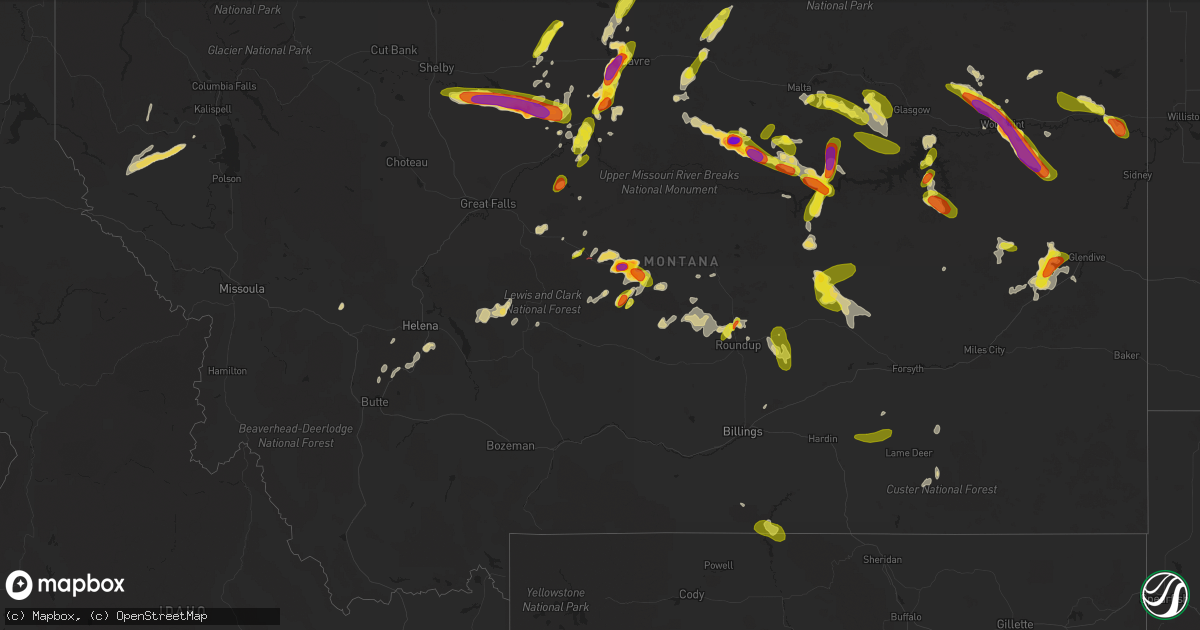
Hail Map in Montana on July 6, 2022
Get this storm
July 6 map
$229
one time, instant access
Download today. No call, no setup
Keep the $229
Bought the map and want the full workflow? Apply the entire $229 to a subscription within 7 days. None of it is wasted.
Every map, not just this one
This buys you this map. Subscription and you get every map we run, in the markets you choose from a few cities to whole states to nationwide. Plus real-time alerts the moment a storm fires.
Contact data
Name, contact info, occupancy, even credit band for addresses in the footprint. You go from where it hit to who to call.
Become the source they trust
Unlimited branding weather history reports on demand. You already have the documented answer ready for the property owner, and you are the one who showed up with it.
Property data and RoofTrace estimates
Pull up any address you have got, its value and the exact code rules for that jurisdiction, straight from One Click Code. Then RoofTrace estimates the squares, pitch, and roof value, priced the way you price.
Storm reports in Montana
Montana
| Date | Description |
|---|---|
| 07/06/20226:52 PM CDT | Pictures submitted via social media of golf ball to egg size hail near moccasin. |
| 07/06/20226:45 PM CDT | Public report of hail up to the size of golf balls in the town of zortman... Lasting for 5 minutes... Until 5:50 pm. |
| 07/06/20226:37 PM CDT | Hail up to tennis ball size. Time estimated. |
| 07/06/20226:36 PM CDT | Corrects incorrect time from previous hail report from zortman. Also reported 0.43 in of rain in 15 min. |
| 07/06/20226:35 PM CDT | Hail around egg size falling west of havre. |
| 07/06/20226:35 PM CDT | Pictures submitted of hail in moore. |
| 07/06/20226:35 PM CDT | Corrects timing from the previous hail report from zortman... Due to connection issues. Relayed via facebook. |
| 07/06/20226:35 PM CDT | A local report indicates 1.25 inch wind near 4 ENE VIDA |
| 07/06/20226:35 PM CDT | Corrects incorrect time from previous hail report from zortman. |
| 07/06/20226:28 PM CDT | Pictures submitted of hail measured with ruler. Spotter also reported 45 mph wind gusts. |
| 07/06/20226:12 PM CDT | Pictures relayed via social media of very large hail near hays. Time of event from radar. |
| 07/06/20226:09 PM CDT | Relayed via facebook. |
| 07/06/20226:02 PM CDT | Pictures submitted via social media of very large hail near moore. |
| 07/06/20225:52 PM CDT | Reported mostly quarter-sized hail with some golf-ball sized. Also reported 0.80 inch precipitation over 30 minutes. Time estimated by radar. |
| 07/06/20225:50 PM CDT | Hail up to golf ball size falling in hobson. |
| 07/06/20225:50 PM CDT | A local report indicates 2.00 inch wind near 5 S WOLF POINT |
| 07/06/20225:45 PM CDT | Relayed via facebook. |
| 07/06/20225:45 PM CDT | Relayed via facebook. |
| 07/06/20225:43 PM CDT | Relayed via facebook. Also reported nickel-sized hail. |
| 07/06/20225:40 PM CDT | Reported half inch to golfball sized hail. Mostly just heavy rainfall right now and calm winds. |
| 07/06/20225:40 PM CDT | Relayed via facebook. |
| 07/06/20225:35 PM CDT | Relayed via facebook as a silver dollar-sized hail. |
| 07/06/20225:30 PM CDT | Relayed via facebook. |
| 07/06/20225:04 PM CDT | Updates previous hail report for virgelle. Spotter submitted additional photos of various sizes of hail. A few stones may be closer to 1.5 inches. |
| 07/06/20224:50 PM CDT | Mainly nickels with quarter-sized hail mixed in. |
| 07/06/20224:50 PM CDT | Spotter estimated 50-60mph gust. |
| 07/06/20224:45 PM CDT | Report relayed via facebook. |
| 07/06/20224:30 PM CDT | Report relayed via twitter. |
| 07/06/20222:18 PM CDT | A likely brief and non impactful tornado across skull butte. Very low funnel cloud well photographed and documented by spotter. Multiple photos show funnel nearly on th |
| 07/06/20222:15 PM CDT | A local report indicates 1.00 inch wind near 5 SW STANFORD |
| 07/06/20224:34 AM CDT | At 934 PM MDT, a severe thunderstorm was located 15 miles northwest of Terry, moving east at 5 mph. HAZARD...60 mph wind gusts and quarter size hail. SOURCE...Radar indicated. IMPACT...Hail damage to vehicles is expected. Expect wind damage to roofs, siding, and trees. Locations impacted include... Terry, Fallon and Mccloud. |
| 07/06/20223:29 AM CDT | At 829 PM MDT, a severe thunderstorm was located 10 miles northwest of Fallon, or 13 miles north of Terry, moving southwest at 15 mph. HAZARD...Ping pong ball size hail and 60 mph wind gusts. SOURCE...Radar indicated. IMPACT...People and animals outdoors will be injured. Expect hail damage to roofs, siding, windows, and vehicles. Expect wind damage to roofs, siding, and trees. Locations impacted include... Terry and Fallon. |
| 07/06/20223:25 AM CDT | At 824 PM MDT, a severe thunderstorm was located 10 miles southwest of Nelson Creek Rec Area, or 25 miles northeast of Jordan, moving southeast at 25 mph. HAZARD...60 mph wind gusts and quarter size hail. SOURCE...Radar indicated. IMPACT...Hail damage to vehicles is expected. Expect wind damage to roofs, siding, and trees. Locations impacted include... Flowing Wells Rest Area and Van Norman. |
| 07/06/20222:51 AM CDT | At 750 PM MDT, a severe thunderstorm was located 9 miles south of Lindsay, or 19 miles west of Glendive, moving west at 5 mph. HAZARD...60 mph wind gusts and quarter size hail. SOURCE...Radar indicated. IMPACT...Hail damage to vehicles is expected. Expect wind damage to roofs, siding, and trees. This severe thunderstorm will remain over mainly rural areas of southwestern Dawson County. |
| 07/06/20222:28 AM CDT | At 728 PM MDT, severe thunderstorms were located along a line extending from 24 miles northeast of Ryegate to 13 miles northeast of Roundup, moving northeast at 15 mph. HAZARD...60 mph wind gusts and quarter size hail. SOURCE...Radar indicated. IMPACT...Hail damage to vehicles is expected. Expect wind damage to roofs, siding, and trees. These severe thunderstorms will remain over mainly rural areas of northwestern Musselshell County. |
| 07/06/20222:24 AM CDT | At 723 PM MDT, a severe thunderstorm was located 18 miles south of Sand Springs, or 39 miles east of Winnett, moving southeast at 10 mph. HAZARD...60 mph wind gusts and half dollar size hail. SOURCE...Radar indicated. IMPACT...Hail damage to vehicles is expected. Expect wind damage to roofs, siding, and trees. This severe thunderstorm will remain over mainly rural areas of northern Rosebud County. |
| 07/06/20222:15 AM CDT | At 715 PM MDT, a severe thunderstorm was located 8 miles south of Glasgow, moving east at 30 mph. HAZARD...60 mph wind gusts and quarter size hail. SOURCE...Radar indicated. IMPACT...Hail damage to vehicles is expected. Expect wind damage to roofs, siding, and trees. Locations impacted include... Nashua, Fort Peck, Fort Peck Marina, Frazer, Duck Creek Rec Area, Park Grove and Whatley. |
| 07/06/20222:13 AM CDT | At 713 PM MDT, a severe thunderstorm was located 17 miles south of Chester, moving east at 25 mph. HAZARD...60 mph wind gusts and half dollar size hail. SOURCE...Radar indicated. IMPACT...Hail damage to vehicles is expected. Expect wind damage to roofs, siding, and trees. Locations impacted include... Tiber Dam and Kenilworth. |
| 07/06/20222:12 AM CDT | At 712 PM MDT, a severe thunderstorm was located 15 miles northeast of Devils Creek Rec Area, or 40 miles southeast of Malta, moving north at 30 mph. HAZARD...60 mph wind gusts and quarter size hail. SOURCE...Radar indicated. IMPACT...Hail damage to vehicles is expected. Expect wind damage to roofs, siding, and trees. Locations impacted include... Content. |
| 07/06/20222:09 AM CDT | At 709 PM MDT, a severe thunderstorm was located 7 miles east of Fourchette, or 36 miles east of Zortman, moving southeast at 50 mph. HAZARD...60 mph wind gusts and quarter size hail. SOURCE...Radar indicated. IMPACT...Hail damage to vehicles is expected. Expect wind damage to roofs, siding, and trees. Locations impacted include... Fourchette, Devils Creek Rec Area, Brusett and Sun Prairie. |
| 07/06/20222:04 AM CDT | At 703 PM MDT, a severe thunderstorm was located near Lindsay, or 18 miles west of Glendive, moving northwest at 25 mph. HAZARD...60 mph wind gusts and quarter size hail. SOURCE...Radar indicated. IMPACT...Hail damage to vehicles is expected. Expect wind damage to roofs, siding, and trees. Locations impacted include... West Glendive, Lindsay and Forest Park. |
| 07/06/20221:56 AM CDT | At 655 PM MDT, a severe thunderstorm was located 7 miles north of Inverness, or 16 miles northeast of Chester, moving north at 10 mph. HAZARD...Quarter size hail. SOURCE...Radar indicated. IMPACT...Damage to vehicles is expected. This severe thunderstorm will remain over mainly rural areas of east central Liberty and northwestern Hill Counties. |
| 07/06/20221:48 AM CDT | At 647 PM MDT, severe thunderstorms were located along a line extending from 25 miles northeast of East Helena to 11 miles west of White Sulphur Springs, moving northeast at 20 mph. HAZARD...60 mph wind gusts and penny size hail. SOURCE...Radar indicated. IMPACT...Expect damage to roofs, siding, and trees. Locations impacted include... White Sulphur Springs, Fort Logan On The Smith River, Checkerboard, Newlan Creek Reservoir and Fort Logan. |
| 07/06/20221:41 AM CDT | At 641 PM MDT, a severe thunderstorm was located 14 miles southwest of Sand Springs, or 35 miles east of Winnett, moving east at 25 mph. HAZARD...Golf ball size hail and 60 mph wind gusts. SOURCE...Radar indicated. IMPACT...People and animals outdoors will be injured. Expect hail damage to roofs, siding, windows, and vehicles. Expect wind damage to roofs, siding, and trees. This severe thunderstorm will remain over mainly rural areas of southwestern Garfield County. |
| 07/06/20221:38 AM CDT | At 637 PM MDT, a severe thunderstorm was located 16 miles northwest of The Pines Rec Area, or 17 miles southwest of Glasgow, moving southeast at 40 mph. HAZARD...Ping pong ball size hail and 60 mph wind gusts. SOURCE...Radar indicated. IMPACT...People and animals outdoors will be injured. Expect hail damage to roofs, siding, windows, and vehicles. Expect wind damage to roofs, siding, and trees. Locations impacted include... The Pines Rec Area, Rock Creek Rec Area and Haxby. |
| 07/06/20221:33 AM CDT | At 632 PM MDT, a severe thunderstorm was located 17 miles south of Melstone, or 27 miles east of Roundup, moving north at 10 mph. HAZARD...60 mph wind gusts and quarter size hail. SOURCE...Radar indicated. IMPACT...Hail damage to vehicles is expected. Expect wind damage to roofs, siding, and trees. Locations impacted include... Musselshell.This warning does not include the city of Billings. |
| 07/06/20221:33 AM CDT | At 633 PM MDT, a severe thunderstorm was located 13 miles southwest of Moore, or 24 miles north of Harlowton, moving northeast at 10 mph. HAZARD...Quarter size hail. SOURCE...Radar indicated. IMPACT...Damage to vehicles is expected. Locations impacted include... Buffalo and Garneill. |
| 07/06/20221:21 AM CDT | At 621 PM MDT, a severe thunderstorm was located 17 miles southeast of Shelby, moving east at 25 mph. HAZARD...60 mph wind gusts and quarter size hail. SOURCE...Radar indicated. IMPACT...Hail damage to vehicles is expected. Expect wind damage to roofs, siding, and trees. Locations impacted include... Tiber Dam. |
| 07/06/20221:17 AM CDT | At 617 PM MDT, a severe thunderstorm was located 9 miles southwest of Tampico, or 16 miles west of Glasgow, moving east at 20 mph. HAZARD...Ping pong ball size hail and 60 mph wind gusts. SOURCE...Radar indicated. IMPACT...People and animals outdoors will be injured. Expect hail damage to roofs, siding, windows, and vehicles. Expect wind damage to roofs, siding, and trees. Locations impacted include... Glasgow and Whatley. |
| 07/06/20221:14 AM CDT | At 613 PM MDT, a severe thunderstorm was located near Devils Creek Rec Area, or 37 miles northwest of Jordan, moving north at 40 mph. HAZARD...60 mph wind gusts and half dollar size hail. SOURCE...Radar indicated. IMPACT...Hail damage to vehicles is expected. Expect wind damage to roofs, siding, and trees. Locations impacted include... Devils Creek Rec Area and Content. |
| 07/06/20221:09 AM CDT | At 608 PM MDT, severe thunderstorms were located along a line extending from 25 miles south of Malta to 11 miles northwest of Fourchette to 24 miles east of Hays to 7 miles southeast of Zortman, moving south at 30 mph. HAZARD...60 mph wind gusts and quarter size hail. SOURCE...Radar indicated. IMPACT...Hail damage to vehicles is expected. Expect wind damage to roofs, siding, and trees. Locations impacted include... Fourchette and Sun Prairie. |
| 07/06/20221:03 AM CDT | At 603 PM MDT, a severe thunderstorm was located 11 miles southwest of Sand Springs, or 34 miles east of Winnett, moving northeast at 10 mph. HAZARD...60 mph wind gusts and quarter size hail. SOURCE...Radar indicated. IMPACT...Hail damage to vehicles is expected. Expect wind damage to roofs, siding, and trees. Locations impacted include... Sand Springs. |
| 07/06/202212:54 AM CDT | At 553 PM MDT, a severe thunderstorm was located 11 miles northwest of Richey, or 23 miles south of Poplar, moving southeast at 30 mph. HAZARD...60 mph wind gusts and quarter size hail. SOURCE...Radar indicated. IMPACT...Hail damage to vehicles is expected. Expect wind damage to roofs, siding, and trees. Locations impacted include... Richey, Lambert, Bloomfield and Enid. |
| 07/06/202212:51 AM CDT | At 550 PM MDT, a severe thunderstorm was located 7 miles northwest of Lame Deer, or 14 miles southwest of Colstrip, moving east at 20 mph. HAZARD...60 mph wind gusts and quarter size hail. SOURCE...Radar indicated. IMPACT...Hail damage to vehicles is expected. Expect wind damage to roofs, siding, and trees. Locations impacted include... Colstrip and Brandenberg. |
| 07/06/202212:50 AM CDT | At 550 PM MDT, a severe thunderstorm was located 18 miles southwest of Hinsdale, or 29 miles west of Glasgow, moving southeast at 45 mph. HAZARD...60 mph wind gusts and half dollar size hail. SOURCE...Radar indicated. IMPACT...Hail damage to vehicles is expected. Expect wind damage to roofs, siding, and trees. Locations impacted include... The Bentonite Plant. |
| 07/06/202212:48 AM CDT | At 548 PM MDT, a severe thunderstorm was located over Moore, or 12 miles southwest of Lewistown, moving east at 10 mph. HAZARD...Quarter size hail. SOURCE...Radar indicated. IMPACT...Damage to vehicles is expected. Locations impacted include... Moore and Glengarry. |
| 07/06/202212:46 AM CDT | At 545 PM MDT, a severe thunderstorm was located 18 miles north of Deadmans Basin Reservoir, or 25 miles northeast of Harlowton, moving north at 10 mph. HAZARD...60 mph wind gusts and quarter size hail. SOURCE...Radar indicated. IMPACT...Hail damage to vehicles is expected. Expect wind damage to roofs, siding, and trees. This severe thunderstorm will remain over mainly rural areas of east central Wheatland and north central Golden Valley Counties. |
| 07/06/202212:44 AM CDT | At 543 PM MDT, a cluster of severe thunderstorms were located along a line extending from 23 miles north of Havre to 8 miles north of Beaver Creek, moving northeast at 35 mph. HAZARD...Quarter size hail. SOURCE...Radar indicated. IMPACT...Damage to vehicles is expected. These severe thunderstorms will remain over mainly rural areas of northeastern Hill County. |
| 07/06/202212:43 AM CDT | At 542 PM MDT, a severe thunderstorm was located 17 miles northwest of Roundup, moving north at 15 mph. HAZARD...60 mph wind gusts and quarter size hail. SOURCE...Radar indicated. IMPACT...Hail damage to vehicles is expected. Expect wind damage to roofs, siding, and trees. This severe thunderstorm will remain over mainly rural areas of northwestern Musselshell and northeastern Golden Valley Counties. |
| 07/06/202212:25 AM CDT | At 524 PM MDT, a severe thunderstorm was located 19 miles northwest of Hays, or 26 miles northwest of Zortman, moving northeast at 15 mph. HAZARD...Quarter size hail. SOURCE...Radar indicated. IMPACT...Damage to vehicles is expected. This severe thunderstorm will remain over mainly rural areas of central Blaine County. |
| 07/06/202212:18 AM CDT | At 517 PM MDT, severe thunderstorms were located along a line extending from 14 miles north of Mosby to 11 miles northwest of Sand Springs, moving northeast at 35 mph. HAZARD...Ping pong ball size hail and 60 mph wind gusts. SOURCE...Radar indicated. IMPACT...People and animals outdoors will be injured. Expect hail damage to roofs, siding, windows, and vehicles. Expect wind damage to roofs, siding, and trees. Locations impacted include... Brusett. |
| 07/06/202212:13 AM CDT | At 513 PM MDT, a severe thunderstorm was located near Beaver Creek, or 11 miles southwest of Havre, moving northeast at 20 mph. HAZARD...Half dollar size hail. SOURCE...Radar indicated. IMPACT...Damage to vehicles is expected. Locations impacted include... Havre, Beaver Creek and Laredo. |
| 07/06/202212:11 AM CDT | At 511 PM MDT, severe thunderstorms were located along a line extending from near Zortman to near Hays, moving east at 30 mph. HAZARD...60 mph wind gusts and quarter size hail. SOURCE...Radar indicated. IMPACT...Hail damage to vehicles is expected. Expect wind damage to roofs, siding, and trees. Locations impacted include... Zortman and Landusky. |
| 07/06/202212:10 AM CDT | At 510 PM MDT, a severe thunderstorm was located over Hays, or near Zortman, moving southeast at 5 mph. HAZARD...Golf ball size hail. SOURCE...Radar indicated. IMPACT...People and animals outdoors will be injured. Expect damage to roofs, siding, windows, and vehicles. Locations impacted include... Hays and Lodge Pole. |
| 07/06/202212:06 AM CDT | At 506 PM MDT, a severe thunderstorm was located 8 miles north of Vida, or 11 miles southeast of Wolf Point, moving southeast at 25 mph. HAZARD...Golf ball size hail and 70 mph wind gusts. SOURCE...Radar indicated. IMPACT...People and animals outdoors will be injured. Expect hail damage to roofs, siding, windows, and vehicles. Expect considerable tree damage. Wind damage is also likely to mobile homes, roofs, and outbuildings. Locations impacted include... Richey and Vida. |
| 07/06/202212:03 AM CDT | At 503 PM MDT, a severe thunderstorm was located 7 miles north of Harlem, moving east at 15 mph. HAZARD...Quarter size hail. SOURCE...Radar indicated. IMPACT...Damage to vehicles is expected. Locations impacted include... Harlem, Turner and Hogeland. |
| 07/05/202211:58 PM CDT | At 458 PM MDT, severe thunderstorms were located along a line extending from 8 miles east of Malta to 23 miles southeast of Dodson, moving southeast at 30 mph. HAZARD...60 mph wind gusts and quarter size hail. SOURCE...Radar indicated. IMPACT...Hail damage to vehicles is expected. Expect wind damage to roofs, siding, and trees. Locations impacted include... The Bentonite Plant and Content. |
| 07/05/202211:54 PM CDT | At 454 PM MDT, a severe thunderstorm was located over Hobson, or 18 miles southeast of Stanford, and is nearly stationary. HAZARD...Ping pong ball size hail. SOURCE...Radar indicated. IMPACT...People and animals outdoors will be injured. Expect damage to roofs, siding, windows, and vehicles. Locations impacted include... Hobson and Moccasin. |
| 07/05/202211:51 PM CDT | At 450 PM MDT, severe thunderstorms were located along a line extending from 20 miles north of Busby to 12 miles southwest of Hardin, moving northeast at 15 mph. HAZARD...60 mph wind gusts and quarter size hail. SOURCE...Radar indicated. IMPACT...Hail damage to vehicles is expected. Expect wind damage to roofs, siding, and trees. Locations impacted include... Hardin, Crow Agency and Crow Indian Reservation. |
| 07/05/202211:27 PM CDT | At 427 PM MDT, a severe thunderstorm was located near Big Sandy, moving northeast at 20 mph. HAZARD...Quarter size hail. SOURCE...Radar indicated. IMPACT...Damage to vehicles is expected. Locations impacted include... Big Sandy, Box Elder, Boneau, Azure, Sangrey and Laredo. |
| 07/05/202211:21 PM CDT | At 421 PM MDT, a severe thunderstorm was located over St. Pierre, or 13 miles east of Big Sandy, moving northeast at 25 mph. HAZARD...Quarter size hail. SOURCE...Radar indicated. IMPACT...Damage to vehicles is expected. Locations impacted include... Azure, Parker School, Agency, Sangrey, St. Pierre, Boneau and Rocky Boy. |
| 07/05/202211:18 PM CDT | At 418 PM MDT, severe thunderstorms were located along a line extending from 8 miles north of Wolf Point to 14 miles northeast of Frazer to 11 miles south of Lustre, moving southeast at 25 mph. HAZARD...Ping pong ball size hail and 60 mph wind gusts. SOURCE...Radar indicated. IMPACT...People and animals outdoors will be injured. Expect hail damage to roofs, siding, windows, and vehicles. Expect wind damage to roofs, siding, and trees. Locations impacted include... Wolf Point, Vida and Oswego. |
| 07/05/202210:58 PM CDT | At 357 PM MDT, a severe thunderstorm was located 11 miles northwest of Hays, or 18 miles northwest of Zortman, moving east at 15 mph. HAZARD...Ping pong ball size hail. SOURCE...Radar indicated. IMPACT...People and animals outdoors will be injured. Expect damage to roofs, siding, windows, and vehicles. Locations impacted include... Hays. |
| 07/05/202210:54 PM CDT | At 354 PM MDT, a severe thunderstorm was located 21 miles south of Chinook, moving east at 5 mph. HAZARD...Quarter size hail. SOURCE...Radar indicated. IMPACT...Damage to vehicles is expected. Locations impacted include... Cleveland. |
| 07/05/202210:38 PM CDT | At 337 PM MDT, a severe thunderstorm was located 9 miles northwest of Hobson, or 10 miles east of Stanford, moving east at 10 mph. HAZARD...Ping pong ball size hail. SOURCE...Radar indicated. IMPACT...People and animals outdoors will be injured. Expect damage to roofs, siding, windows, and vehicles. Locations impacted include... Moccasin and Benchland. |
| 07/05/202210:32 PM CDT | At 332 PM MDT, a severe thunderstorm was located 7 miles southwest of Lustre, or 24 miles northwest of Wolf Point, moving east at 25 mph. HAZARD...60 mph wind gusts and half dollar size hail. SOURCE...Radar indicated. IMPACT...Hail damage to vehicles is expected. Expect wind damage to roofs, siding, and trees. Locations impacted include... Lustre and Volt. |
| 07/05/202210:16 PM CDT | At 316 PM MDT, a severe thunderstorm was located near Bredette, or 23 miles north of Poplar, moving northeast at 20 mph. HAZARD...60 mph wind gusts and quarter size hail. SOURCE...Radar indicated. IMPACT...Hail damage to vehicles is expected. Expect wind damage to roofs, siding, and trees. Locations impacted include... Bredette. |
| 07/05/202210:09 PM CDT | At 308 PM MDT, a severe thunderstorm was located 17 miles northwest of Hays, or 24 miles northwest of Zortman, moving east at 15 mph. HAZARD...Half dollar size hail. SOURCE...Radar indicated. IMPACT...Damage to vehicles is expected. This severe thunderstorm will remain over mainly rural areas of south central Blaine County. |
| 07/05/20229:55 PM CDT | At 254 PM MDT, a severe thunderstorm was located 11 miles northeast of Brockton, or 13 miles northwest of Culbertson, moving east at 25 mph. HAZARD...60 mph wind gusts and quarter size hail. SOURCE...Radar indicated. IMPACT...Hail damage to vehicles is expected. Expect wind damage to roofs, siding, and trees. Locations impacted include... Froid and Mccabe. |
| 07/05/20228:49 PM CDT | Relayed via facebook. |
| 07/05/20228:36 PM CDT | Relayed via facebook. 1.9 in rainfall with pea-sized hail. |
| 07/05/20228:30 PM CDT | Observed via raws site. |
| 07/05/20228:23 PM CDT | Largest hail stone was tennis ball... With most stones averaging ping pong size. Leaves on trees were shredded... With damage done to shingles and windows of house/vehi |
| 07/05/20228:18 PM CDT | A local report indicates 1.50 inch wind near 15 N RUDYARD |
| 07/05/20228:14 PM CDT | At 114 PM MDT, a severe thunderstorm was located near Stanford, moving northeast at 15 mph. HAZARD...60 mph wind gusts and quarter size hail. SOURCE...Radar indicated. IMPACT...Hail damage to vehicles is expected. Expect wind damage to roofs, siding, and trees. Locations impacted include... Stanford, Denton, Coffee Creek, Windham and Benchland. |
| 07/05/20228:13 PM CDT | Report of dime to quarter size hail via social media. |
| 07/05/20228:01 PM CDT | Also reported 1 in of rainfall in 15 min. |
| 07/05/20227:36 PM CDT | Also reported 0.43 in of rain in 15 min. |
| 07/05/20227:34 PM CDT | A local report indicates 1.75 inch wind near ZORTMAN |
| 07/05/20227:30 PM CDT | Reported 1 inch hail over a 30 minute period. |
All States Impacted by Hail Map on July 6, 2022
Cities Impacted by Hail Map on July 6, 2022
- Joplin, MT
- Chinook, MT
- Lavina, MT
- Roundup, MT
- Bowman, ND
- Frazer, MT
- Poplar, MT
- Avon, MT
- Hobson, MT
- Buffalo, MT
- Forsyth, MT
- Loma, MT
- Chester, MT
- Ledger, MT
- Fort Benton, MT
- Big Sandy, MT
- Inverness, MT
- Glendive, MT
- Lindsay, MT
- Terry, MT
- Brusett, MT
- Geyser, MT
- Grass Range, MT
- Elkfork, KY
- Sandy Hook, KY
- Axtell, KS
- Corning, KS
- Clearmont, MO
- Greensburg, IN
- Havensville, KS
- Mitchell, OR
- Lame Deer, MT
- Birney, MT
- Glendale, KY
- Cecilia, KY
- Martin, KY
- Banner, KY
- Allen, KY
- Prestonsburg, KY
- Dana, KY
- Apple Grove, WV
- Gallipolis Ferry, WV
- Hamptonville, NC
- Hartford, KY
- Akron, CO
- Max Meadows, VA
- Piedmont, SC
- Pelzer, SC
- Williamston, SC
- Booker, TX
- Perryton, TX
- Balko, OK
- Hettinger, ND
- Mott, ND
- New Leipzig, ND
- New Raymer, CO
- Grover, CO
- Havre, MT
- Kremlin, MT
- Rudyard, MT
- Hingham, MT
- Ryegate, MT
- Stanford, MT
- Shepherd, MT
- Huntley, MT
- Fairmont, NE
- Box Elder, MT
- Cheyenne Wells, CO
- Glenarm, IL
- Chatham, IL
- Hogeland, MT
- Harlem, MT
- Elizabeth, IN
- Towner, ND
- Rugby, ND
- Gillette, WY
- Haddam, KS
- Egnar, CO
- Othello, WA
- Batavia, OH
- Pleasant Plain, OH
- Blanchester, OH
- Goshen, OH
- Rocky Ford, CO
- Manzanola, CO
- Vida, MT
- Richey, MT
- Wolf Point, MT
- Limon, CO
- Matheson, CO
- Jordan, MT
- Cohagen, MT
- Powell, WY
- White Sulphur Springs, MT
- Winnett, MT
- Prineville, OR
- Goff, KS
- Atchison, KS
- Bethune, CO
- Narka, KS
- Culbertson, MT
- Lancaster, MN
- Musselshell, MT
- Gordon, NE
- Rushville, NE
- Malta, MT
- Zortman, MT
- Hays, MT
- Dodson, MT
- Lloyd, MT
- Jefferson City, MT
- Clancy, MT
- Boulder, MT
- Belfield, ND
- Crowley, CO
- Ordway, CO
- Olney Springs, CO
- Fallon, MT
- Hardy, NE
- Fairbury, NE
- Lewistown, MT
- Ingomar, MT
- Sand Springs, MT
- La Junta, CO
- Union Point, GA
- Blue Hill, NE
- Hurdle Mills, NC
- Owingsville, KY
- Mount Sterling, KY
- Frenchburg, KY
- Olympia, KY
- Means, KY
- Hope, KY
- Jeffersonville, KY
- Thompsonville, IL
- Ware Shoals, SC
- Laurens, SC
- McIntosh, SD
- Fort Peck, MT
- Amidon, ND
- Deaver, WY
- Marion, MT
- Raynesford, MT
- Belt, MT
- Morrisonville, IL
- Pawnee, IL
- Lead, SD
- Helmville, MT
- Willow Wood, OH
- Scottown, OH
- Chesapeake, OH
- Merino, CO
- Kila, MT
- Townsend, MT
- Bighorn, MT
- Verdon, NE
- Sebree, KY
- Ellis, KS
- Salt Lick, KY
- Williamsburg, OH
- Bethel, OH
- Georgetown, OH
- Hamersville, OH
- Mount Orab, OH
- Ramah, CO
- Calhan, CO
- Minneola, KS
- Kit Carson, CO
- Franktown, CO
- Castle Rock, CO
- Elbert, CO
- Bridger, MT
- Buffalo, WY
- Kaycee, WY
- Jetmore, KS
- Rineyville, KY
- Watauga, SD
- Selfridge, ND
- Morristown, SD
- Wray, CO
- Williamsport, OH
- Lawson, MO
- Springfield, OH
- South Charleston, OH
- Hinsdale, MT
- Geraldine, MT
- Whiting, KS
- Netawaka, KS
- Horton, KS
- Custer, SD
- Nezperce, ID
- Ferdinand, ID
- New England, ND
- South Heart, ND
- Lathrop, MO
- Turney, MO
- Keystone, SD
- Hermosa, SD
- Wetmore, KS
- Londonderry, OH
- Chillicothe, OH
- Laurelville, OH
- Kingston, OH
- Seneca, KS
- Wathena, KS
- Saint Joseph, MO
- Fort Morgan, CO
- Basin, MT
- Hot Springs, MT
- Plains, MT
- Brockton, MT
- Froid, MT
- Moore, MT
- Moccasin, MT
- Forest Grove, MT
- Craigmont, ID
- Lewiston, ID
- Imnaha, OR
- Enterprise, OR
- Cottonwood, ID
- Elizabethtown, IN
- Ewing, KY
- Mullinville, KS
- Randleman, NC
- Pleasant Garden, NC
- Andersonville, TN
- Heiskell, TN
- Strunk, KY
- Corydon, IN
- Winnsboro, SC
- Winchester, KY
- Inman, SC
- Campobello, SC
- Monroe, NC
- Brockway, MT
- Russell Springs, KY
- Glens Fork, KY
- Columbia, KY
- Ruskin, FL
- Flagler, CO
- Vona, CO
- Sunnyside, WA
- Grandview, WA
- Prosser, WA
- Mabton, WA
- Toppenish, WA
- Plattsburg, MO
- Blackstone, VA
- Seibert, CO
- South Bloomingville, OH
- Glenwood, MO
- Lancaster, MO
- Coatsville, MO
- Larkspur, CO
- Sedalia, CO
- Fayetteville, OH
- Spray, OR
- Belleville, KS
- Munden, KS
- Washington, KS
- Denton, NC
- Trinity, NC
- Lexington, NC
- Rush Center, KS
- Larned, KS
- Henderson, NE
- Sutton, NE
- Grafton, NE
- McCool Junction, NE
- Rozel, KS
- Shubert, NE
- Everest, KS
- Robinson, KS
- Kiowa, CO
- Bennett, CO
- Elizabeth, CO
- Red Cloud, NE
- Albany, KY
- Butlerville, IN
- Manchester, KY
- Bessemer City, NC
- Kings Mountain, NC
- Gurley, AL
- Procious, WV
- Sweetwater, TN
- Athens, TN
- Equality, IL
- Canon, GA
- Murphy, NC
- Waynesville, NC
- Hodgenville, KY
- New Hope, KY
- New Haven, KY
- Bowman, GA
- Royston, GA
- Central, SC
- Lutts, TN
- Sunbright, TN
- East Bernstadt, KY
- Livingston, KY
- Hillsboro, OH
- Lynchburg, OH
- Ayden, NC
- Ringgold, GA
- Laurel Springs, NC
- Pendleton, SC
- Fountain Inn, SC
- Simpsonville, SC
- Abilene, KS
- Spartanburg, SC
- Wellford, SC
- Hanston, KS
- Kinsley, KS
- Tell City, IN
- Ellinwood, KS
- Great Bend, KS
- Lilburn, GA
- Trimble, MO
- Scranton, SC
- Timmonsville, SC
- Olanta, SC
- Tellico Plains, TN
- Lamar, SC
- Matthews, NC
- Waxhaw, NC
- Indian Trail, NC
- Charlotte, NC
- Pacolet, SC
- Bowersville, GA
- Lavonia, GA
- Hartwell, GA
- Clifton Hill, MO
- Huntsville, MO
- Martin, GA
- Carnesville, GA
- Lewisburg, OH
- Linn, KS
- Rockwood, TN
- Maryville, MO
- Pickering, MO
- Strasburg, CO
- Morrowville, KS
- Peyton, CO
- Minneapolis, KS
- Greenville, SC
- Ford, KS
- Spearville, KS
- Hoisington, KS
- Albert, KS
- Olmitz, KS
- McCracken, KS
- Bison, KS
- Otis, KS
- La Crosse, KS
- Crestwood, KY
- La Grange, KY
- Buckner, KY
- Pedro, OH
- Weston, CO
- Capron, VA
- Yale, VA
- Salisbury, NC
- Richfield, NC
- Danielsville, GA
- Wendell, NC
- Raleigh, NC
- Wake Forest, NC
- Knightdale, NC
- Gable, SC
- Alcolu, SC
- New Zion, SC
- Stephens, GA
- Eatonton, GA
- Madison, GA
- Washington Court House, OH
- New Holland, OH
- Mount Sterling, OH
- Casar, NC
- Gladstone, VA
- Appomattox, VA
- Tribune, KS
- Holly, CO
- Marshall, NC
- Tazewell, TN
- Rainsville, AL
- Watertown, TN
- Milton, TN
- Dunn, NC
- Niota, TN
- Elloree, SC
- Santee, SC
- Clyde, NC
- Canton, NC
- Reevesville, SC
- Saint George, SC
- Inavale, NE
- Big Clifty, KY
- Thorn Hill, TN
- Mooresburg, TN
- Bean Station, TN
- Waverly, VA
- Petersburg, VA
- Carson, VA
- Stony Creek, VA
- Disputanta, VA
- Miami, TX
- Rosston, OK
- Rock Hill, SC
- Fort Mill, SC
- Lancaster, SC
- Hickory, NC
- Morganton, NC
- Connelly Springs, NC
- Vale, NC
- Hildebran, NC
- Oxford, NC
- Bullock, NC
- Henderson, NC
- State Road, NC
- Wise, VA
- Coeburn, VA
- Taylorsville, NC
- Ten Mile, TN
- Buckhead, GA
- Philadelphia, TN
- Idalia, CO
- Brownell, KS
- Arcanum, OH
- Jamesport, MO
- Chillicothe, MO
- Stewartsville, MO
- Briggsdale, CO
- Fairfield, NE
- Glenvil, NE
- Fairfax, MO
- Leitchfield, KY
- Flatgap, KY
- Oil Springs, KY
- West Liberty, KY
- Ironton, OH
- Baileyville, KS
- Centralia, KS
- Frankfort, KS
- Vermillion, KS
- Cleveland, TN
- McBee, SC
- Sardinia, OH
- Laverne, OK
- Partridge, KY
- Cumberland, KY
- Clay City, KY
- Irvine, KY
- Clintwood, VA
- Franklin, NC
- Shelby, NC
- Cherryville, NC
- Lawndale, NC
- Good Hope, GA
- Mountville, SC
- Apollo Beach, FL
- Soldier, KS
- Cedar Bluff, AL
- Gaylesville, AL
- Clifton, KS
- Cuba, KS
- Agenda, KS
- Karval, CO
- Simla, CO
- Hugo, CO
- Wild Horse, CO
- Effingham, KS
- Muscotah, KS
- Flemingsburg, KY
- Mayslick, KY
- Clendenin, WV
- Oakdale, TN
- Ashland, KS
- Leopold, IN
- Knoxville, TN
- Nebo, NC
- Belton, SC
- Etowah, TN
- Reliance, TN
- Toccoa, GA
- Westminster, SC
- Saint Matthews, SC
- Swansea, SC
- Turbeville, SC
- Lake City, SC
- Lyman, SC
- Bowman, SC
- Ridgeway, SC
- Jonesville, SC
- Lenoir, NC
- Englewood, TN
- Sumter, SC
- Manning, SC
- Liberty, KY
- Dunnville, KY
- Yosemite, KY
- Luttrell, TN
- Maynardville, TN
- Ruffin, SC
- Borger, TX
- Hollywood, AL
- Scottsboro, AL
- Fackler, AL
- Gainesville, GA
- Society Hill, SC
- Burlington, CO
- Syracuse, KS
- Guilford, MO
- Portsmouth, OH
- McDermott, OH
- Churchville, VA
- Staunton, VA
- Vesuvius, VA
- Hustonville, KY
- Amherst, VA
- Lynchburg, VA
- Forest, VA
- Pound, VA
- Beaver Dam, KY
- Centertown, KY
- Sumerco, WV
- Julian, WV
- Sugar City, CO
- Gaffney, SC
- Jefferson, NC
- Millers Creek, NC
- Landrum, SC
- Anderson, SC
- Eastanollee, GA
- Chocowinity, NC
- Sheridan Lake, CO
- Fraziers Bottom, WV
- Buffalo, WV
- Proctorville, OH
- Offerle, KS
- Clarkson, KY
- Camden, OH
- Vanceboro, NC
- Grimesland, NC
- Greenville, NC
- Lyons, KS
- Crouse, NC
- Smithville, MO
- Saluda, NC
- Columbus, NC
- Tryon, NC
- Rogersville, TN
- Falls City, NE
- Kirk, CO
- Kenna, WV
- Charleston, WV
- Given, WV
- Advent, WV
- Liberty, WV
- Harrodsburg, KY
- Salvisa, KY
- Salley, SC
- Wagener, SC
- Nokesville, VA
- Manassas, VA
- Woodbridge, VA
- Sparta, GA
- Lancing, TN
- Duluth, GA
- Suwanee, GA
- Cimarron, KS
- Greer, SC
- Phenix, VA
- Summerton, SC
- Stearns, KY
- Varnville, SC
- Bazine, KS
- Cross Plains, IN
- Canaan, IN
- Madison, IN
- Bennington, IN
- Versailles, IN
- Liebenthal, KS
- Madison Heights, VA
- Monroe, VA
- Lancaster, KS
- Denton, KS
- McDonald, TN
- Ooltewah, TN
- Raymond, KS
- Wakeeney, KS
- Chase, KS
- Hudson, KS
- St John, KS
- Alexander, KS
- Claflin, KS
- Pawnee Rock, KS
- Boiling Springs, SC
- Caryville, TN
- Franklin, TN
- Corryton, TN
- Kersey, CO
- Orchard, CO
- Weldona, CO
- Gill, CO
- Log Lane Village, CO
- Brush, CO
- Blue Rapids, KS
- Randolph, KS
- Lebanon, KS
- Troy, KS
- Bendena, KS
- Galatia, IL
- Carrier Mills, IL
- East Flat Rock, NC
- Hendersonville, NC
- Flat Rock, NC
- Collinwood, TN
- Eastview, KY
- Gray, GA
- La Fayette, GA
- Leicester, NC
- Townville, SC
- Oliver Springs, TN
- Oak Ridge, TN
- Osborn, MO
- Cameron, MO
- Palouse, WA
- Garfield, WA
- Onaga, KS
- Knightstown, IN
- Oregon, MO
- Forest City, MO
- Maitland, MO
- North Vernon, IN
- Smith Center, KS
- Westport, IN
- Fair Play, SC
- Monticello, KY
- Colerain, NC
- Vance, SC
- Rock Spring, GA
- Honea Path, SC
- Fritch, TX
- Agency, MO
- Easton, MO
- Ellenboro, NC
- Amazonia, MO
- Agate, CO
- Clinton, SC
- Godwin, NC
- Jamestown, KY
- Dry Branch, GA
- Canyon, TX
- Winfield, WV
- Hurricane, WV
- Milton, WV
- Glenwood, WV
- Williamston, NC
- Washington, NC
- Ocala, FL
- Una, SC
- Linden, TN
- Grandview, TN
- Andrews, NC
- Holt, MO
- Elkview, WV
- Walton, WV
- Prospect, KY
- Franklin Furnace, OH
- Sharpsburg, KY
- Moorefield, KY
- Mauldin, SC
- Deer Lodge, TN
- Zebulon, NC
- Islandton, SC
- Saint Albans, WV
- Nitro, WV
- Dunbar, WV
- Scott Depot, WV
- Cleves, OH
- Highland, KS
- Versailles, KY
- Kingston, TN
- Clarksdale, MO
- Helena, MO
- Cosby, MO
- Amity, MO
- Union Star, MO
- Courtland, KS
- Republic, KS
- Scandia, KS
- Crown City, OH
- Wytheville, VA
- Middleburg, KY
- Spring City, TN
- Roxboro, NC
- Social Circle, GA
- Rocky Mount, VA
- Glade Hill, VA
- Branchville, SC
- Lake Bronson, MN
- Outlook, WA
- Glasgow, MT
- Victor, MT
- Byers, CO
- Snyder, CO
- Galeton, CO
- Eaton, CO
- Yuma, CO
- Las Animas, CO
- Lamar, CO
- Lovell, WY
- Fairview, MT
- Nashua, MT
- Hardin, MT
- Crow Agency, MT
- Worden, MT
- Shelby, MT
- Highwood, MT
- Circle, MT
- Lincoln, KS
- Beverly, KS
- Sunman, IN
- Milan, IN
- Osgood, IN
- Moores Hill, IN
- Hebron, KY
- Burlington, KY
- Erlanger, KY
- Florence, KY
- Bellevue, KY
- Ft Mitchell, KY
- Latonia, KY
- Fort Thomas, KY
- Newport, KY
- Cincinnati, OH
- Covington, KY
- Terrace Park, OH
- Milford, OH


