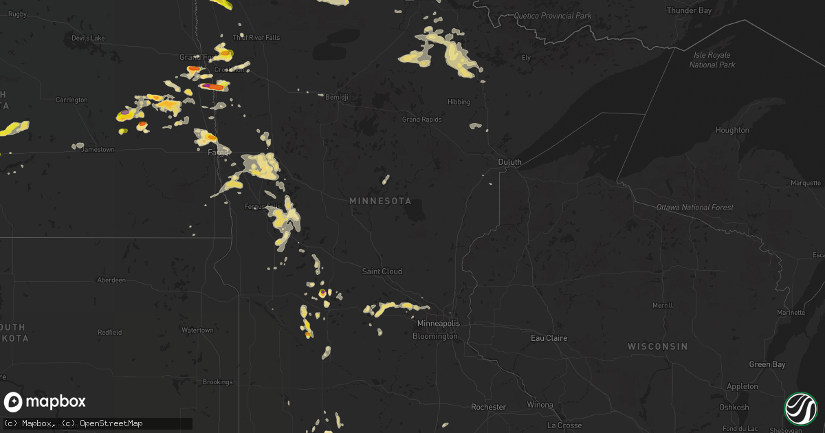
Hail Map in Minnesota on July 4, 2017
Get this storm
July 4 map
$229
one time, instant access
Download today. No call, no setup
Keep the $229
Bought the map and want the full workflow? Apply the entire $229 to a subscription within 7 days. None of it is wasted.
Every map, not just this one
This buys you this map. Subscription and you get every map we run, in the markets you choose from a few cities to whole states to nationwide. Plus real-time alerts the moment a storm fires.
Contact data
Name, contact info, occupancy, even credit band for addresses in the footprint. You go from where it hit to who to call.
Become the source they trust
Unlimited branding weather history reports on demand. You already have the documented answer ready for the property owner, and you are the one who showed up with it.
Property data and RoofTrace estimates
Pull up any address you have got, its value and the exact code rules for that jurisdiction, straight from One Click Code. Then RoofTrace estimates the squares, pitch, and roof value, priced the way you price.
Storm reports in Minnesota
Minnesota
| Date | Description |
|---|---|
| 07/04/20176:49 PM CDT | Photo and report posted via social media. |
| 07/04/20176:49 PM CDT | Photo and report posted via social media. |
| 07/04/20176:48 PM CDT | Picture messaged on facebook to fsd. |
| 07/04/20176:45 PM CDT | Picture submitted via facebook. |
| 07/04/20176:30 PM CDT | Photo submitted via facebook. |
| 07/04/20176:20 PM CDT | Hail began around 6 pm cdt and continues through report time at 6:20 pm. Largest stones were golf ball sized. |
| 07/04/20176:10 PM CDT | A local report indicates 1.00 inch wind near 6 WNW SPICER |
| 07/04/20171:30 AM CDT | Large branches broken down. Power outages between vergas and big mcdonald lake. Report posted via social media. |
| 07/04/20171:05 AM CDT | A few large hail and very heavy rains. |
| 07/04/20171:02 AM CDT | A local report indicates 1.25 inch wind near 10 WNW ROTHSAY |
| 07/04/201712:25 AM CDT | A local report indicates 1.00 inch wind near 3 N ROLLAG |
| 07/03/201710:45 PM CDT | A local report indicates 1.00 inch wind near 7 ENE CLIMAX |
| 07/03/201710:30 PM CDT | A few dime to quarter sized hail in heavy rain. |
| 07/03/201710:18 PM CDT | Very heavy rain. Hail was pretty soft. Not much wind. |
| 07/03/20179:30 PM CDT | A local report indicates 1.00 inch wind near 4 W EUCLID |
| 07/03/20179:20 PM CDT | Report and photo posted via social media. Hail between gentilly and crookston... Along the bypass. Time estimated based on radar. |
| 07/03/20179:00 PM CDT | Time estimated from radar. |
| 07/03/20178:51 PM CDT | A local report indicates 1.00 inch wind near 1 NE CLARA CITY |
| 07/03/20178:50 PM CDT | A local report indicates 1.50 inch wind near 8 N CROOKSTON |
| 07/03/20178:45 PM CDT | A local report indicates 1.50 inch wind near 1 NNE CLARA CITY |
| 07/03/20178:42 PM CDT | A local report indicates 1.50 inch wind near EUCLID |
| 07/03/20178:12 PM CDT | A local report indicates 1.00 inch wind near 4 ESE ROUND LAKE |
| 07/03/20177:40 PM CDT | Photo shared on facebook. |
| 07/03/20177:25 PM CDT | A local report indicates 1.75 inch wind near FLORIAN |
| 07/03/20177:01 PM CDT | A local report indicates 1.00 inch wind near 7 WSW BROOTEN |
All States Impacted by Hail Map on July 4, 2017
Cities Impacted by Hail Map on July 4, 2017
- Hettinger, ND
- Dassel, MN
- Annandale, MN
- Maple Lake, MN
- Buffalo, MN
- Cokato, MN
- Howard Lake, MN
- Buxton, ND
- Stephen, MN
- Angora, MN
- Cook, MN
- Faith, SD
- Union Center, SD
- Logan, NM
- Colbert, OK
- Galesburg, ND
- Clifford, ND
- Portland, ND
- Hope, ND
- La Junta, CO
- Las Animas, CO
- Wood River, NE
- Littlefork, MN
- Orr, MN
- Memphis, TX
- Childress, TX
- Arthur, IA
- Kiron, IA
- Ida Grove, IA
- Elgin, OK
- Lawton, OK
- Luverne, ND
- Hannaford, ND
- Bussey, IA
- Loraine, TX
- Bronte, TX
- Merkel, TX
- Jackson, MN
- Lakefield, MN
- Nara Visa, NM
- Weinert, TX
- Munday, TX
- Battle Lake, MN
- Murdock, MN
- Clara City, MN
- Raymond, MN
- Austin, AR
- Vilonia, AR
- Jacksonville, AR
- Cabot, AR
- Arnold, NE
- Thompson, ND
- Rapid City, SD
- Palestine, AR
- Goodwin, AR
- Boswell, OK
- Vining, MN
- Clitherall, MN
- Parkers Prairie, MN
- Midkiff, TX
- Griffithville, AR
- Des Arc, AR
- Groom, TX
- Donaldson, MN
- Karlstad, MN
- Strandquist, MN
- Dumas, TX
- Seymour, TX
- New London, MN
- Roswell, NM
- Hershey, NE
- Sutherland, NE
- Paxton, NE
- Athol, KS
- Gaylord, KS
- Kensington, KS
- Ozona, TX
- Lonoke, AR
- Carlisle, AR
- Kanawha, IA
- Milan, MN
- Peru, IA
- Saint Charles, IA
- Murray, IA
- Truro, IA
- Stapleton, NE
- Brady, NE
- Maxwell, NE
- North Platte, NE
- Roosevelt, OK
- Ordway, CO
- Wolverton, MN
- Finley, ND
- Black Hawk, SD
- Deadwood, SD
- Nemo, SD
- Brewster, MN
- Adrian, TX
- Argusville, ND
- Mayville, ND
- Haxtun, CO
- Pacolet, SC
- Altus, OK
- Henrietta, TX
- Ellendale, MN
- Blooming Prairie, MN
- Wallace, NE
- Dickens, NE
- Hawley, MN
- Detroit Lakes, MN
- Garita, NM
- Meadowlands, MN
- Cotton, MN
- Willis, VA
- Harris, IA
- Lake Park, IA
- Round Lake, MN
- Worthington, MN
- Okabena, MN
- Heron Lake, MN
- Vergas, MN
- Pelican Rapids, MN
- Audubon, MN
- Lake Park, MN
- Elsie, NE
- Roaring Springs, TX
- Paducah, TX
- Wrenshall, MN
- Temple, OK
- Britt, IA
- Corwith, IA
- Hallock, MN
- Spicer, MN
- Willmar, MN
- Greenbrier, AR
- Baudette, MN
- Cove, AR
- Watson, OK
- Crete, NE
- Hutchinson, MN
- Grenville, NM
- Crookston, MN
- Nielsville, MN
- Climax, MN
- Bismarck, ND
- Wing, ND
- Tuttle, ND
- Menoken, ND
- Mandan, ND
- Baldwin, ND
- Regan, ND
- Robinson, ND
- Red Lake Falls, MN
- Searcy, AR
- Higginson, AR
- Miami, TX
- Canadian, TX
- Fairbury, IL
- Pontiac, IL
- Forrest, IL
- Saint Petersburg, FL
- Evansville, MN
- Brooten, MN
- Belgrade, MN
- Litchfield, MN
- Darwin, MN
- Scott, AR
- Petrolia, TX
- Wichita Falls, TX
- Claude, TX
- San Jon, NM
- Mentone, TX
- Prairie City, SD
- Sylvester, TX
- Trafford, AL
- Locust Fork, AL
- Cleveland, AL
- Euclid, MN
- Shamrock, TX
- Pennock, MN
- Sunburg, MN
- Ashby, MN
- Underwood, MN
- Henning, MN
- Dalton, MN
- Detroit, TX
- Vail, IA
- Denison, IA
- Hillsboro, ND
- Sentinel, OK
- Gardner, ND
- Elberton, GA
- Dazey, ND
- Wimbledon, ND
- Cooperstown, ND
- Moorhead, MN
- Glyndon, MN
- Tryon, NE
- Trent, TX
- Sweetwater, TX
- Hale Center, TX
- Bellevue, TX
- Redwood Falls, MN
- Olivia, MN
- Glencoe, MN
- Silver Lake, MN
- Newtown, MO
- Frederick, OK
- Snyder, OK
- Glenwood, MN
- Big Spring, TX
- Carson, ND
- Ogema, MN
- Ulen, MN
- Callaway, MN
- Kim, CO
- Avondale, CO
- Pueblo, CO
- Roscoe, TX
- Hugo, OK
- Fort Towson, OK
- International Falls, MN
- Lemmon, SD
- Lindsay, OK
- Coahoma, TX
- Effie, MN
- Moffit, ND
- Sterling, ND
- Kennedy, MN
- Gann Valley, SD
- Sedgwick, CO
- Mcalister, NM
- Melrose, NM
- Elmore, MN
- Hoffman, MN
- Barrett, MN
- Albany, TX
- Valley City, ND
- Lucerne, MO
- Pollock, MO
- Mapleton, ND
- Harwood, ND
- Casselton, ND
- Dexter, IA
- Redfield, IA
- Loving, NM
- Haskell, TX
- Rocky Ford, CO
- Tipton, OK
- Hunter, ND
- Muleshoe, TX
- Kermit, TX
- Rogers, MN
- Hanover, MN
- Masterson, TX
- Amarillo, TX
- Widener, AR
- Tunica, MS
- Atoka, OK
- Coalgate, OK
- Dunning, NE
- Foreman, AR
- Ashdown, AR
- Hatton, ND
- Big Falls, MN
- Blair, OK
- Mangum, OK
- Alexandria, MN
- Atlanta, LA
- Blackwell, TX
- Maryneal, TX
- Warren, MN
- Osceola, IA
- Sugar City, CO
- Mclean, TX
- Marianna, AR
- Hazen, AR
- White Deer, TX
- Altamonte Springs, FL
- Apopka, FL
- Orlando, FL
- Trenton, NC
- Dover, NC
- Debary, FL
- Jal, NM
- Saint Jo, TX
- Ringling, OK
- Hamlin, TX
- Lidgerwood, ND
- Burr, NE
- Grand Forks, ND
- Douglas, NE
- Cook, NE
- Sterling, NE
- Syracuse, NE
- Northome, MN
- Fergus Falls, MN
- Brandon, MN
- Crowell, TX
- Nocona, TX
- Winter Park, FL
- Maitland, FL
- Alden, MN
- Hollandale, MN
- Austin, MN
- Norton, TX
- Solway, MN
- Broken Bow, OK
- Loveland, OK
- Rush Springs, OK
- Marlow, OK
- Rothsay, MN
- Kent, MN
- Shields, ND
- Selfridge, ND
- Portales, NM
- Texico, NM
- Reynolds, ND
- Ada, MN
- Thief River Falls, MN
- Elk River, MN
- Anoka, MN
- Braddock, ND
- Byers, TX
- Clarendon, TX
- Adamsville, TN
- Selmer, TN
- Stringtown, OK
- Howes, SD
- Robert Lee, TX
- Cape Coral, FL
- Waurika, OK
- Ryan, OK
- Hermleigh, TX
- Damascus, AR
- Beebe, AR
- Hereford, TX
- Kensington, MN
- Garfield, MN
- Elbow Lake, MN
- Hawley, TX
- Anson, TX
- Atwater, MN
- Solen, ND
- Flasher, ND
- Smithville, OK
- Plumerville, AR
- Earleton, FL
- Chattanooga, OK
- Loretto, MN
- Maple Grove, MN
- Dayton, MN
- Saint Michael, MN
- Rockford, MN
- Minneapolis, MN
- Osseo, MN
- Champlin, MN
- Hamel, MN
- Arthur, ND
- Trementina, NM
- Pampa, TX
- Bennington, OK
- Shickley, NE
- Geneva, NE
- Avoca, TX
- Stamford, TX
- Winters, TX
- Friona, TX
- Sterling City, TX
- Maple Plain, MN
- Many, LA
- Thonotosassa, FL
- Zephyrhills, FL
- Wesley Chapel, FL
- Bricelyn, MN
- Kiester, MN
- Spirit Lake, IA
- Winterset, IA
- Garden City, TX
- Britt, MN
- Barnesville, MN
- Okahumpka, FL
- Groveland, FL
- Leesburg, FL
- Judsonia, AR
- Albert Lea, MN
- Wells, MN
- Emerado, ND
- Rotan, TX
- Ward, AR
- Artesia, NM
- Punta Gorda, FL
- Fairburn, SD
- Sherwood, AR
- Clarksville, TX
- Little Rock, AR
- North Little Rock, AR
- Fort Sumner, NM
- Lueders, TX
- Skellytown, TX
- Bigfork, MN
- Chisholm, MN
- Rogers, ND
- Hastings, OK
- Randlett, OK
- Borger, TX
- Channing, TX
- Morris, MN
- Westbrook, TX
- Cheraw, CO
- Ivanhoe, TX
- Cedartown, GA
- Wahpeton, ND
- Colfax, ND
- Sacred Heart, MN
- Maynard, MN
- Bagley, MN
- Walters, OK
- McCaulley, TX
- Viking, MN
- Kerkhoven, MN
- Cleveland, ND
- Virginia, MN
- Eads, TN
- Cordova, TN
- Memphis, TN
- Fisher, MN
- East Grand Forks, MN
- Benson, MN
- Lovilia, IA
- Delight, AR
- Wesley, IA
- Fletcher, OK
- Deloit, IA
- Rattan, OK
- Dent, MN
- Abercrombie, ND
- Frazee, MN
- Earlham, IA
- Beltrami, MN
- Bismarck, AR
- Malvern, AR
- Nashville, AR
- Mineral Springs, AR
- Sarasota, FL
- Duncan, OK
- Quitaque, TX
- Lone Wolf, OK
- Buffalo Center, IA
- Villard, MN
- Durant, OK
- Mead, OK
- Augusta, AR
- Bald Knob, AR
- Erhard, MN
- Nesbit, MS
- Merrifield, MN
- Anselmo, NE
- Sawyer, OK
- Murfreesboro, AR
- Snyder, TX
- Halstad, MN
- Blue Earth, MN
- Kress, TX
- Santa Rosa, NM
- Tulia, TX
- Collierville, TN
- Burt, IA
- Windom, MN
- Soper, OK
- Millington, TN
- Jonesville, SC
- Spartanburg, SC
- Roff, OK
- Lakota, IA
- Boone, CO
- Bingham Lake, MN
- Currie, MN
- Hamilton, IA
- Broadview, NM
- Biscoe, AR
- Ira, TX
- Richville, MN
- Naples, FL
- Page, ND
- Sarah, MS
- Beverly Hills, FL
- Lecanto, FL
- Hot Springs National Park, AR
- Donaldson, AR
- Jayton, TX
- Antlers, OK
- Stonewall, OK
- Cyrus, MN
- Hartley, TX
- Renville, MN
- Benton, AR
- Wynne, AR
- South Haven, MN
- Miles, TX
- Ballinger, TX
- Gadsden, AL
- Jamestown, ND
- Meadow, SD
- Mountain Lake, MN
- Butterfield, MN
- Trimont, MN
- Odin, MN
- Indiahoma, OK
- Hobart, OK
- Driscoll, ND
- Bonham, TX
- Savoy, TX
- Shelly, MN
- Panhandle, TX
- Colorado City, TX
- Snow, OK
- Finley, OK
- Moyers, OK
- Chariton, IA
- Erie, ND
- Arlington, TN
- Foster, OK
- Dill City, OK
- Carter, OK
- Colora, MD
- Blakesburg, IA
- Unionville, IA
- Paoli, OK
- Brayton, IA
- Anita, IA
- Starke, FL
- Rufe, OK
- Valliant, OK
- Gotebo, OK
- Hollister, OK
- Canute, OK
- Littlefield, TX
- Steele, ND
- Carlton, MN
- Lowell, IN
- Ackworth, IA
- Traskwood, AR
- Paynesville, MN
- Rule, TX
- Lovington, NM
- Bowman, GA
- Dewy Rose, GA
- Sulphur, OK
- Crosby, MN
- Nisswa, MN
- Stuttgart, AR
- De Valls Bluff, AR
- Fort Sill, OK
- Wilton, AR
- Woden, IA
- Brinkley, AR
- Keldron, SD
- Hastings, NE
- Oakland, TN
- Somerville, TN
- Northwood, ND
- Germantown, TN
- Ovid, CO
- Amity, AR
- Elmer, OK
- Georgetown, MN
- Dilworth, MN
- Fargo, ND
- Farwell, MN
- Sabin, MN
- Moro, AR
- Mountain Park, OK
- Veblen, SD
- Salol, MN
- Bolivar, TN
- Schleswig, IA
- Horatio, AR
- Wheatley, AR
- Cotton Plant, AR
- Columbia, SC
- Madill, OK
- Western, NE
- Bancroft, IA
- Rising Sun, MD
- Pauls Valley, OK
- Plainview, TX
- Mena, AR
- North Fort Myers, FL
- Saint Paul, MN
- Kinston, NC
- Sauk Centre, MN
- Juniata, NE
- Lockesburg, AR
- Morton, MN
- Ree Heights, SD
- Warroad, MN
- Paris, TX
- Williams, MN
- Eatonton, GA
- Conway, AR
- Wynnewood, OK
- Grant, OK
- Aurelia, IA
- Springfield, AR
- Bellflower, IL
- Arrowsmith, IL
- Farmer City, IL
- Barney, ND
- Manilla, IA
- Manning, IA
- Grandin, ND
- Madrid, NE


