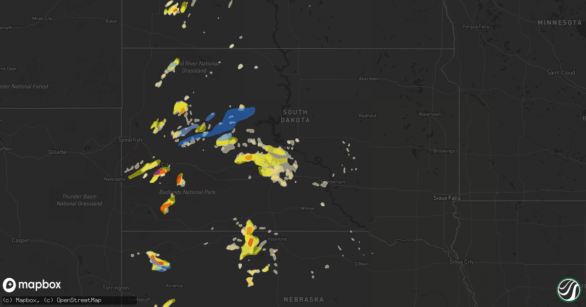
Hail Map in South Dakota on July 2, 2020
Get this storm
July 2 map
$229
one time, instant access
Download today. No call, no setup
Keep the $229
Bought the map and want the full workflow? Apply the entire $229 to a subscription within 7 days. None of it is wasted.
Every map, not just this one
This buys you this map. Subscription and you get every map we run, in the markets you choose from a few cities to whole states to nationwide. Plus real-time alerts the moment a storm fires.
Contact data
Name, contact info, occupancy, even credit band for addresses in the footprint. You go from where it hit to who to call.
Become the source they trust
Unlimited branding weather history reports on demand. You already have the documented answer ready for the property owner, and you are the one who showed up with it.
Property data and RoofTrace estimates
Pull up any address you have got, its value and the exact code rules for that jurisdiction, straight from One Click Code. Then RoofTrace estimates the squares, pitch, and roof value, priced the way you price.
Storm reports in South Dakota
South Dakota
| Date | Description |
|---|---|
| 07/02/20206:13 PM CDT | Lots of tree limbs down |
| 07/02/20205:53 PM CDT | Lots of tree limbs down |
| 07/02/20205:48 PM CDT | A local report indicates 1.00 inch wind near 1 SW MARCUS |
| 07/02/20205:33 PM CDT | Estimated at least 60 mph wind gusts |
| 07/02/20205:30 PM CDT | Photo shows several large hail stones up to golf ball sized |
| 07/02/20205:20 PM CDT | Time estimated from radar. Had been melting for at least half an hour. |
| 07/02/20205:14 PM CDT | A local report indicates 60 MPH wind near ENNING |
| 07/02/20205:12 PM CDT | Also a 49 mph wind gust before hail broke anemometer. |
| 07/02/20205:10 PM CDT | Pea to quarter sized hail covered the ground. Time of onset of large hail estimated from radar. |
| 07/02/20205:10 PM CDT | Photo shows hail measured at least 2 inches in diameter. |
| 07/02/20205:09 PM CDT | A local report indicates 73 MPH wind near 3 W UNION CENTER |
| 07/02/20205:00 PM CDT | Photo shows several measured hail stones approximately two inches in diameter |
| 07/02/20204:34 PM CDT | A local report indicates 59 MPH wind near 7 NNE RALPH |
| 07/02/20204:34 PM CDT | Started at this time and fell for about five minutes. |
| 07/02/20204:30 PM CDT | Image compared to a quarter shows hail about half dollar sized. Start time estimated from radar. |
| 07/02/20204:30 PM CDT | Photo shows hail of at least half dollar sized. Time estimated from radar. |
| 07/02/20204:29 PM CDT | A local report indicates 59 MPH wind near 7 NNE RALPH |
| 07/02/20204:20 PM CDT | Picture of hail showed some stones of at least half dollar size |
| 07/02/20204:10 PM CDT | A local report indicates 1.00 inch wind near 2 S PACTOLA RESV |
| 07/02/20204:09 PM CDT | Lots of 3/4 to inch hail |
| 07/02/20204:06 PM CDT | Most were pea to dime size but a few larger |
| 07/02/20204:00 PM CDT | Time of largest hail estimated from radar. |
| 07/02/20203:38 PM CDT | A local report indicates 60 MPH wind near 1 ENE MUD BUTTE |
| 07/02/20203:20 PM CDT | Delayed report. Time estimated from radar. |
| 07/02/20202:56 PM CDT | A local report indicates 1.00 inch wind near 3 SE NEWELL |
| 07/02/20205:55 AM CDT | At 1055 PM CDT, a severe thunderstorm was located near Miller, moving east at 35 mph. HAZARD...60 mph wind gusts and quarter size hail. SOURCE...Radar indicated. IMPACT...Hail damage to vehicles is expected. Expect wind damage to roofs, siding, and trees. This severe thunderstorm will be near... St. Lawrence around 1105 PM CDT. Vayland around 1115 PM CDT. |
| 07/02/20204:29 AM CDT | At 929 PM CDT/829 PM MDT/, severe thunderstorms were located along a line extending from 14 miles south of Fort Pierre to 6 miles south of Okaton, moving southeast at 60 mph. HAZARD...60 mph wind gusts and quarter size hail. SOURCE...Radar indicated. IMPACT...Hail damage to vehicles is expected. Expect wind damage to roofs, siding, and trees. Severe thunderstorms will be near... Westover around 945 PM CDT. Presho around 950 PM CDT. Fate Dam around 955 PM CDT. Kennebec around 1000 PM CDT. |
| 07/02/20204:16 AM CDT | At 916 PM CDT/816 PM MDT/, a severe thunderstorm was located 7 miles southwest of Fort Pierre, moving east at 40 mph. HAZARD...60 mph wind gusts and quarter size hail. SOURCE...Radar indicated. IMPACT...Hail damage to vehicles is expected. Expect wind damage to roofs, siding, and trees. This severe thunderstorm will be near... Cedar Creek Rec Area around 1000 PM CDT. |
| 07/02/20203:52 AM CDT | At 852 PM CDT/752 PM MDT/, a severe thunderstorm was located near Bunker, or 27 miles east of Philip, moving east at 15 mph. HAZARD...Two inch hail and 60 mph wind gusts. SOURCE...Radar indicated. IMPACT...People and animals outdoors will be injured. Expect hail damage to roofs, siding, windows, and vehicles. Expect wind damage to roofs, siding, and trees. This severe thunderstorm will be near... Bunker around 800 PM MDT. Capa around 820 PM MDT. Van Metre around 845 PM MDT. |
| 07/02/20203:33 AM CDT | At 833 PM CDT/733 PM MDT/, severe thunderstorms were located along a line extending from near Bush'S Landing to 7 miles northwest of Van Metre, moving east at 30 mph. HAZARD...60 mph wind gusts and nickel size hail. SOURCE...Radar indicated. IMPACT...Expect damage to roofs, siding, and trees. Severe thunderstorms will be near... Wendte around 755 PM MDT. |
| 07/02/20203:17 AM CDT | At 817 PM CDT/717 PM MDT/, a severe thunderstorm was located over Nenzel, or 28 miles west of Valentine, moving northeast at 15 mph. HAZARD...Ping pong ball size hail and 60 mph wind gusts. SOURCE...Radar indicated. IMPACT...People and animals outdoors will be injured. Expect hail damage to roofs, siding, windows, and vehicles. Expect wind damage to roofs, siding, and trees. Locations impacted include... Cody, Kilgore, Nenzel, Cody Lake and Anderson Bridge State Wildlife Management Area.This includes Highway 20 between mile markers 158 and 184. |
| 07/02/20203:07 AM CDT | At 807 PM CDT, a severe thunderstorm was located 4 miles southwest of Spring Creek, or 26 miles southwest of Mission, moving east at 15 mph. HAZARD...Ping pong ball size hail and 60 mph wind gusts. SOURCE...Radar indicated. IMPACT...People and animals outdoors will be injured. Expect hail damage to roofs, siding, windows, and vehicles. Expect wind damage to roofs, siding, and trees. This severe thunderstorm will be near... Spring Creek around 820 PM CDT. Saint Francis around 845 PM CDT. |
| 07/02/20203:07 AM CDT | At 807 PM CDT/707 PM MDT/, severe thunderstorms were located along a line extending from 8 miles northwest of Little Bend Rec Area to near Bunker, moving east at 30 mph. HAZARD...60 mph wind gusts and nickel size hail. SOURCE...Radar indicated. IMPACT...Expect damage to roofs, siding, and trees. Severe thunderstorms will be near... Little Bend Rec Area around 720 PM MDT. Bush'S Landing around 730 PM MDT. Sutton Bay Rec Area and Wendte around 845 PM CDT. |
| 07/02/20202:46 AM CDT | At 745 PM CDT/645 PM MDT/, severe thunderstorms were located along a line extending from near Trail City to 12 miles northwest of Little Bend Rec Area, moving east at 30 mph. HAZARD...60 mph wind gusts. SOURCE...Radar indicated. IMPACT...Expect damage to roofs, siding, and trees. Severe thunderstorms will be near... New Everets Resort around 720 PM MDT. |
| 07/02/20202:35 AM CDT | At 733 PM MDT, a severe thunderstorm was located 4 miles southeast of Ottumwa, or 22 miles northeast of Philip, moving east at 30 mph. HAZARD...60 mph wind gusts and half dollar size hail. SOURCE...Radar indicated. IMPACT...Hail damage to vehicles is expected. Expect wind damage to roofs, siding, and trees. This severe thunderstorm will remain over mainly rural areas of southeastern Haakon County, around 5 miles south of Ottumwa. |
| 07/02/20201:27 AM CDT | A local report indicates 61 MPH wind near 5 W PICKSTOWN |
| 07/02/20201:05 AM CDT | A local report indicates 62 MPH wind near 3 N MITCHELL |
| 07/02/202012:59 AM CDT | At 559 PM MDT, a severe thunderstorm was located over South Eagle Butte, or over Eagle Butte, moving east at 45 mph. HAZARD...60 mph wind gusts and penny size hail. SOURCE...Radar indicated. IMPACT...Expect damage to roofs, siding, and trees. This severe thunderstorm will be near... Parade around 610 PM MDT. Ridgeview around 630 PM MDT. |
| 07/02/202012:53 AM CDT | A local report indicates 62 MPH wind near 1 NE WINNER |
| 07/02/202012:37 AM CDT | A local report indicates 62 MPH wind near 1 SW PLANKINTON |
| 07/02/202012:27 AM CDT | A local report indicates 59 MPH wind near PLANKINTON |
| 07/02/202012:20 AM CDT | At 519 PM MDT, a severe thunderstorm was located near Takini School, or 24 miles southeast of Faith, moving east at 30 mph. HAZARD...60 mph wind gusts. SOURCE...Radar indicated. IMPACT...Expect damage to roofs, siding, and trees. This severe thunderstorm will remain over mainly rural areas of northern Haakon, southern Ziebach and east central Meade Counties. |
| 07/02/202012:16 AM CDT | At 515 PM MDT, a severe thunderstorm was located 5 miles southeast of Black Gap, or 12 miles southeast of Rapid City, moving northeast at 25 mph. Another thunderstorm was near Hayward and was also moving east at 20 mph. HAZARD...Quarter size hail. SOURCE...Radar indicated. IMPACT...Damage to vehicles is expected. Locations impacted include... New Underwood, Hermosa, Caputa, Farmingdale, Hayward, Rapid City Airport, Hart Ranch, Black Gap, Thompson Butte, Railroad Buttes and northeastern Custer State Park.This includes Interstate 90 in South Dakota between Mile Markers 75and 82. |
| 07/02/202012:15 AM CDT | Delayed entry. Mesonet station 154 sd rwis platte-winner bridge. |
| 07/02/202012:05 AM CDT | A local report indicates 62 MPH wind near HURON |
| 07/01/202011:50 PM CDT | At 450 PM MDT, a severe thunderstorm was located 5 miles southeast of White Owl, or 37 miles southwest of Faith, moving northeast at 30 mph. HAZARD...60 mph wind gusts. SOURCE...Trained weather spotters. IMPACT...Expect damage to roofs, siding, and trees. This severe thunderstorm will be near... Plainview and Marcus around 510 PM MDT. Howes around 525 PM MDT. |
| 07/01/202011:27 PM CDT | At 427 PM MDT, a severe thunderstorm was located 8 miles north of Elm Springs, or 40 miles northeast of Rapid City, moving east at 30 mph. HAZARD...60 mph wind gusts. SOURCE...Radar indicated. IMPACT...Expect damage to roofs, siding, and trees. This severe thunderstorm will remain over mainly rural areas of southeastern Meade and northeastern Pennington Counties. |
| 07/01/202011:16 PM CDT | At 416 PM MDT, a severe thunderstorm was located near Enning, or 39 miles southwest of Faith, moving northeast at 25 mph. HAZARD...70 mph wind gusts and quarter size hail. SOURCE...Radar indicated. IMPACT...Hail damage to vehicles is expected. Expect considerable tree damage. Wind damage is also likely to mobile homes, roofs, and outbuildings. This severe thunderstorm will be near... Red Owl and White Owl around 430 PM MDT. Marcus around 450 PM MDT. |
| 07/01/202011:03 PM CDT | At 402 PM MDT, a severe thunderstorm was located 4 miles northeast of Hayward, or 10 miles south of Rapid City, moving east at 25 mph. HAZARD...Ping pong ball size hail and 60 mph wind gusts. SOURCE...Radar indicated. IMPACT...People and animals outdoors will be injured. Expect hail damage to roofs, siding, windows, and vehicles. Expect wind damage to roofs, siding, and trees. This severe thunderstorm will be near... Southern Rapid City around 410 PM MDT. Hart Ranch around 415 PM MDT. Black Gap around 420 PM MDT. Rapid City Airport and Thompson Butte around 435 PM MDT. Caputa around 440 PM MDT. Farmingdale around 450 PM MDT.This includes Interstate 90 in South Dakota between Mile Markers 72and 76. |
| 07/01/202010:58 PM CDT | At 358 PM MDT, a severe thunderstorm was located 8 miles southwest of Intersection of Red Shirt and Cuny Table Roads, or 22 miles east of Hot Springs, moving northeast at 20 mph. HAZARD...Ping pong ball size hail and 60 mph wind gusts. SOURCE...Radar indicated. IMPACT...People and animals outdoors will be injured. Expect hail damage to roofs, siding, windows, and vehicles. Expect wind damage to roofs, siding, and trees. Locations impacted include... Oral, Oelrichs, Smithwick, Red Shirt, Red Shirt Table Overlook, Hay Canyon Butte and Intersection of Red Shirt and Cuny Table Roads. |
| 07/01/202010:25 PM CDT | At 325 PM MDT, severe thunderstorms were located along a line extending from 5 miles east of Folsom to near Scenic, moving northeast at 30 mph. HAZARD...60 mph wind gusts and quarter size hail. SOURCE...Radar indicated. IMPACT...Hail damage to vehicles is expected. Expect wind damage to roofs, siding, and trees. Severe thunderstorms will be near... Scenic around 330 PM MDT. Northern Badlands National Park around 355 PM MDT. Owanka around 400 PM MDT. Wall, Wasta and Wicksville around 410 PM MDT.This includes Interstate 90 in South Dakota between Mile Markers 80and 113. |
| 07/01/202010:12 PM CDT | At 311 PM MDT, a severe thunderstorm was located 10 miles north of Prairie City, or 23 miles south of Hettinger, moving northeast at 35 mph. HAZARD...Ping pong ball size hail and 60 mph wind gusts. SOURCE...Radar indicated. IMPACT...People and animals outdoors will be injured. Expect hail damage to roofs, siding, windows, and vehicles. Expect wind damage to roofs, siding, and trees. This severe thunderstorm will be near... Lodgepole around 330 PM MDT. Northwestern Shadehill Reservoir around 355 PM MDT. White Butte around 400 PM MDT. |
| 07/01/20209:59 PM CDT | At 259 PM MDT, a severe thunderstorm was located 3 miles south of Hayward, or 13 miles east of Custer, moving northeast at 25 mph. HAZARD...Ping pong ball size hail. SOURCE...Radar indicated. IMPACT...People and animals outdoors will be injured. Expect damage to roofs, siding, windows, and vehicles. This severe thunderstorm will be near... Hermosa around 315 PM MDT. Thompson Butte around 345 PM MDT. Farmingdale around 355 PM MDT. |
| 07/01/20209:57 PM CDT | At 256 PM MDT, a severe thunderstorm was located 3 miles west of Sheridan Lake, or 3 miles northeast of Hill City, moving east at 25 mph. HAZARD...60 mph wind gusts and half dollar size hail. SOURCE...Radar indicated. IMPACT...Hail damage to vehicles is expected. Expect wind damage to roofs, siding, and trees. Locations impacted include... Rapid City, Hill City, Rapid Valley, Black Hawk, Keystone,Rockerville, Mount Rushmore National Memorial, Bear Country, Hart Ranch, Crazy Horse Memorial, Sylvan Lake, Sheridan Lake, Black Gap, Black Elk Peak and Horse Thief Lake.This includes Interstate 90 in South Dakota between Mile Markers 54and 63. |
| 07/01/20209:47 PM CDT | At 247 PM MDT, a severe thunderstorm was located 5 miles northeast of Mud Butte, or 36 miles west of Faith, moving north at 30 mph. HAZARD...Ping pong ball size hail and 60 mph wind gusts. SOURCE...Radar indicated. IMPACT...People and animals outdoors will be injured. Expect hail damage to roofs, siding, windows, and vehicles. Expect wind damage to roofs, siding, and trees. This severe thunderstorm will remain over mainly rural areas of north central Meade and southwestern Perkins Counties. |
| 07/01/20209:06 PM CDT | At 205 PM MDT, a severe thunderstorm was located 4 miles west of Bear Mountain Lookout, or 13 miles northwest of Custer, moving northeast at 25 mph. HAZARD...Golf ball size hail. SOURCE...Radar indicated. IMPACT...People and animals outdoors will be injured. Expect damage to roofs, siding, windows, and vehicles. This severe thunderstorm will be near... Bear Mountain Lookout around 215 PM MDT. Sylvan Lake around 230 PM MDT. Black Elk Peak around 235 PM MDT. Hill City and Palmer Gulch Resort around 240 PM MDT. Horse Thief Lake and Mount Rushmore National Memorial around 245 PM MDT. Silver City, and Pactola Reservoir around 250 PM MDT. Rockerville around 300 PM MDT. |
| 07/01/20208:53 PM CDT | At 153 PM MDT, a severe thunderstorm was located near Owl Butte, or 23 miles northeast of Sturgis, moving northeast at 15 mph. HAZARD...Ping pong ball size hail and 60 mph wind gusts. SOURCE...Radar indicated. IMPACT...People and animals outdoors will be injured. Expect hail damage to roofs, siding, windows, and vehicles. Expect wind damage to roofs, siding, and trees. This severe thunderstorm will be near... Owl Butte around 200 PM MDT. |
| 07/01/20208:48 PM CDT | A local report indicates 1.50 inch wind near 8 ESE OTTUMWA |
| 07/01/20208:20 PM CDT | At 120 PM MDT, a severe thunderstorm was located 3 miles northeast of Newcastle, moving east at 10 mph. HAZARD...Ping pong ball size hail. SOURCE...Radar indicated. IMPACT...People and animals outdoors will be injured. Expect damage to roofs, siding, windows, and vehicles. This severe thunderstorm will be near... Moon around 215 PM MDT. |
| 07/01/20207:16 PM CDT | 50-60 mph with pea sized hail and very heavy rain. |
All States Impacted by Hail Map on July 2, 2020
Cities Impacted by Hail Map on July 2, 2020
- Monett, MO
- Burlington, CO
- Valentine, NE
- Alpena, AR
- Little Rock, AR
- Coldwater, MS
- Medway, ME
- Hays, KS
- Lake Village, AR
- Presho, SD
- Vivian, SD
- Scott City, KS
- Arapahoe, CO
- Sheridan Lake, CO
- Richardton, ND
- Mud Butte, SD
- Faith, SD
- Wray, CO
- Wilmar, AR
- Lansford, ND
- Glenburn, ND
- Stark, KS
- Savonburg, KS
- Dover, AR
- Rocklake, ND
- Rolla, ND
- Hansboro, ND
- Dunn Center, ND
- Taylor, ND
- Halliday, ND
- Rapid City, SD
- St John, KS
- Dodd City, TX
- Windom, TX
- Bayard, NE
- Panhandle, TX
- Gurley, NE
- Peetz, CO
- Sidney, NE
- Deer, AR
- Parshall, ND
- Roseglen, ND
- Belleville, KS
- Scandia, KS
- Concordia, KS
- Jamestown, KS
- Kilgore, NE
- Nenzel, NE
- Oakley, KS
- Hanston, KS
- Kinsley, KS
- Saint James, MO
- Chandler, OK
- Perryville, AR
- Fort Worth, TX
- Gregory, SD
- Bethune, CO
- Carl Junction, MO
- Joplin, MO
- Webb City, MO
- Monticello, AR
- Grady, AR
- Fairfax, OK
- Pierce City, MO
- Hill City, SD
- Keystone, SD
- Goodland, KS
- Clarksville, AR
- Lamar, AR
- Prairie City, SD
- Cope, CO
- Anton, CO
- Buena Vista, GA
- Union Center, SD
- Newell, SD
- Bird City, KS
- Saint Francis, KS
- Benkelman, NE
- Gladstone, ND
- Hemingford, NE
- Lamar, CO
- Wiley, CO
- Hasty, CO
- McClave, CO
- Harvey, ND
- Chaseley, ND
- Bowdon, ND
- Burr Oak, KS
- Tupelo, OK
- De Witt, AR
- Greenville, MS
- Leland, MS
- Bentonia, MS
- Newcastle, WY
- Hermosa, SD
- Oberon, ND
- Springdale, AR
- Oral, SD
- Pine Ridge, SD
- Champion, NE
- Carpio, ND
- Salina, KS
- Alexander, AR
- Mabelvale, AR
- Bauxite, AR
- Howes, SD
- Pierre, SD
- Blunt, SD
- Guide Rock, NE
- Searcy, AR
- Hugo, OK
- Rison, AR
- Lake Wales, FL
- Atwood, KS
- Selden, KS
- Hoxie, KS
- Rexford, KS
- Lexington, MS
- Cruger, MS
- Sturgis, SD
- Mulberry, AR
- Ryan, OK
- Crawford, NE
- Dumas, AR
- Healy, KS
- Grinnell, KS
- Ogallala, NE
- Paxton, NE
- Keystone, NE
- Harrison, AR
- Rolette, ND
- Rugby, ND
- White Owl, SD
- Whitman, NE
- Max, NE
- Lincoln, KS
- Sylvan Grove, KS
- Drumright, OK
- Dresden, KS
- Yale, OK
- Regent, ND
- Hettinger, ND
- Colby, KS
- Garden City, KS
- Leslie, AR
- Dickinson, ND
- New England, ND
- Amidon, ND
- Midland, SD
- Draper, SD
- Fort Pierre, SD
- Okaton, SD
- Murdo, SD
- Hayes, SD
- Satanta, KS
- Berthold, ND
- Lindsborg, KS
- Assaria, KS
- Reva, SD
- Edson, KS
- Utica, KS
- Hominy, OK
- Vale, SD
- Madison, ME
- Sarah, MS
- Crenshaw, MS
- Indianola, MS
- Hollandale, MS
- Inverness, MS
- Stratton, CO
- Cody, NE
- Tuthill, SD
- Saint Francis, SD
- Aladdin, WY
- Marsland, NE
- Rogers, AR
- Yazoo City, MS
- Glenpool, OK
- Phillips, WI
- Lebanon, NE
- Shaw, MS
- Doddsville, MS
- Kensal, ND
- Booneville, AR
- Ponca, AR
- Garfield, KS
- Belpre, KS
- Larned, KS
- Guymon, OK
- Chamberlain, SD
- England, AR
- Pine Bluff, AR
- Cherry Creek, SD
- Philip, SD
- Milesville, SD
- Miller, SD
- Lakin, KS
- Belzoni, MS
- Crookston, NE
- Shell Knob, MO
- Washburn, ND
- Hayes Center, NE
- Mountain View, AR
- Magazine, AR
- Thedford, NE
- Pawhuska, OK
- Shidler, OK
- Burbank, OK
- Granada, CO
- Berryville, AR
- Hudson, KS
- Maple City, KS
- Dexter, KS
- Herndon, KS
- Hernando, MS
- Lyon, MS
- Clarksdale, MS
- Silver City, MS
- Hudson, ME
- Spencer, NE
- Oneill, NE
- Waxahachie, TX
- Cedar Hill, TX
- Midlothian, TX
- McIntosh, SD
- McLaughlin, SD
- Kanorado, KS
- Victoria, KS
- Walker, KS
- Gorham, KS
- Wood, SD
- Tulsa, OK
- Sapulpa, OK
- Sand Springs, OK
- Belleville, AR
- Danville, AR
- Plaza, ND
- Ryder, ND
- Killdeer, ND
- Green Forest, AR
- Abilene, KS
- Solomon, KS
- Minter City, MS
- Charleston, MS
- Akron, CO
- Bolton, MS
- Wasta, SD
- Enning, SD
- Winner, SD
- Hamill, SD
- Wauneta, NE
- Stratton, NE
- Oxford, MS
- Water Valley, MS
- Tutwiler, MS
- Imperial, NE
- Enders, NE
- Superior, NE
- Dundee, MS
- Sledge, MS
- Isola, MS
- Mankato, KS
- Yellville, AR
- Caputa, SD
- Holdenville, OK
- Wetumka, OK
- Parthenon, AR
- Woodworth, ND
- Sheridan, AR
- Warren, AR
- Elkhart, KS
- Jenks, OK
- Pittsboro, MS
- Tillar, AR
- Perth, ND
- Vernon, CO
- Weskan, KS
- Parks, NE
- Sterling, CO
- Kress, TX
- Red Oak, TX
- Otis, KS
- Pfeifer, KS
- Russell, KS
- Jetmore, KS
- Ellis, KS
- Scenic, SD
- New Salem, ND
- Dighton, KS
- Milburn, OK
- Kenefic, OK
- Brewster, KS
- Eagle Butte, SD
- Dupree, SD
- Lantry, SD
- Gove, KS
- Aurora, MO
- Reeds Spring, MO
- Brinkley, AR
- Hamburg, AR
- Pittsburg, KS
- Asbury, MO
- Coleharbor, ND
- Milo, ME
- Seligman, MO
- Garfield, AR
- Eagle Rock, MO
- Keller, TX
- Elkins, AR
- Fayetteville, AR
- Weleetka, OK
- Bassett, NE
- Bridgeport, NE
- Angora, NE
- Batesville, AR
- Portales, NM
- Wessington Springs, SD
- Gypsum, KS
- Cape Fair, MO
- Beeler, KS
- Sterling, KS
- Omaha, AR
- Mounds, OK
- Pritchett, CO
- Okemah, OK
- Seminole, OK
- Sarcoxie, MO
- Selfridge, ND
- Mayersville, MS
- Carrington, ND
- Brownell, KS
- McCracken, KS
- Burdett, KS
- Cherokee, KS
- Weir, KS
- Cushing, OK
- Poteau, OK
- Meadow, SD
- Joes, CO
- Vona, CO
- Kirk, CO
- Senatobia, MS
- Coahoma, MS
- Gordon, NE
- Columbus, KS
- Hollister, MO
- Bisbee, ND
- Knox, ND
- Hugoton, KS
- Moscow, KS
- Glencoe, OK
- Sarles, ND
- Lefor, ND
- Kinta, OK
- Park, KS
- Quinter, KS
- Wisner, LA
- Morland, KS
- Denhoff, ND
- Goodrich, ND
- Merigold, MS
- Ruleville, MS
- Cleveland, MS
- Ferriday, LA
- Dardanelle, AR
- Sahuarita, AZ
- Hazen, ND
- Stanton, ND
- Culbertson, NE
- Carthage, MO
- Reeds, MO
- Bixby, OK
- Stuart, NE
- Lenora, KS
- Stillwater, OK
- Mccurtain, OK
- Great Bend, KS
- Jefferson, AR
- Penokee, KS
- Hill City, KS
- Huntsville, AR
- Harmony, ME
- Hunter, KS
- Belcourt, ND
- Curtis, NE
- Snow Lake, AR
- Watson, AR
- Merriman, NE
- Lodgepole, SD
- Hagarville, AR
- Altus, AR
- Ozark, AR
- Hartman, AR
- Houlton, ME
- Cassville, MO
- Carson, ND
- Uniontown, KS
- Golden, MO
- Bisbee, AZ
- Tombstone, AZ
- Thorndike, ME
- Troy, ME
- Harrison, NE
- Oark, AR
- Redfield, AR
- Madrid, NE
- Galena, MO
- Potter, NE
- Portis, KS
- Oronogo, MO
- Paris, AR
- Claude, TX
- Troy, NY
- Dalton, NE
- Eustis, NE
- Lowell, AR
- Stafford, KS
- Lewis, KS
- Macksville, KS
- Branson, MO
- Okmulgee, OK
- Gann Valley, SD
- Downs, KS
- Long Pine, NE
- Dustin, OK
- Belvidere, SD
- Winona, KS
- Monument, KS
- Marienthal, KS
- Holly, CO
- Ruso, ND
- Benedict, ND
- Grant, NE
- Bingham, ME
- Ralston, OK
- Buffalo, SD
- Duncan, MS
- Anderson, MO
- Pineville, MO
- Bristow, OK
- Valley Springs, AR
- Lampe, MO
- Anson, ME
- Newton, KS
- Mylo, ND
- Fairfield, ME
- Gainesville, MO
- Wing, ND
- Galena, KS
- Ponca City, OK
- Martin, SD
- Stuart, FL
- Indiantown, FL
- Osborne, KS
- Cuba, MO
- Pawnee, OK
- Benton, AR
- Ellinwood, KS
- Portland, AR
- Waterford, NY
- Mechanicville, NY
- Beloit, KS
- Tribune, KS
- Elgin, ND
- Ulysses, KS
- Sublette, KS
- Kingsland, AR
- Bearden, AR
- Sherman, ME
- Eureka Springs, AR
- Plainview, AR
- Humphrey, AR
- Louise, MS
- Anguilla, MS
- Wall, SD
- Marietta, OK
- Waterville, ME
- Chapman, KS
- Saint Bernard, LA
- Helena, AR
- Drew, MS
- Scranton, AR
- Turtle Lake, ND
- Ripley, OK
- Beggs, OK
- Pea Ridge, AR
- Oviedo, FL
- Orlando, FL
- Minneapolis, KS
- Grapevine, AR
- Island Falls, ME
- Wasola, MO
- Glen Allan, MS
- Chatham, MS
- McCook, NE
- Maywood, NE
- Mansfield, TX
- Girard, KS
- Maypearl, TX
- Venus, TX
- Napoleon, ND
- Lamar, OK
- Barnard, KS
- Jasper, AR
- Perkins, OK
- Coalgate, OK
- Athens, ME
- Sundance, WY
- Marble Falls, AR
- Marks, MS
- Shelby, MS
- Mound Bayou, MS
- Hindsville, AR
- Tryon, OK
- Brookston, TX
- Moundridge, KS
- Ransom, KS
- Miami, OK
- Kingston, AR
- Roxton, TX
- Milford, KS
- Bradford, AR
- Saint Lawrence, SD
- Johnson, KS
- Chadwick, MO
- Almont, ND
- Hurdsfield, ND
- Makoti, ND
- Plainville, KS
- Langdon, ND
- Barnsdall, OK
- White Hall, AR
- Ivan, AR
- Pingree, ND
- Pleasant Grove, AR
- Ennis, TX
- Hensley, AR
- Prosper, TX
- Oberlin, KS
- Red Rock, OK
- Como, MS
- North Anson, ME
- Chestnutridge, MO
- Walnut Shade, MO
- Hanna, OK
- Brookville, KS
- New Underwood, SD
- Newport, AR
- Verona, MO
- Purdy, MO
- Esbon, KS
- Augusta, AR
- Fort Lauderdale, FL
- Fordyce, AR
- Gould, AR
- Sicily Island, LA
- Flippin, AR
- Compton, AR
- Waldron, AR
- Wapanucka, OK
- Pickens, AR
- Bartley, NE
- Indianola, NE
- Hermleigh, TX
- Holyrood, KS
- Claflin, KS
- Freistatt, MO
- Gunnison, MS
- Fairfax, SD
- Butte, NE
- Washburn, MO
- Banks, AR
- Whitney, NE
- Clinton, AR
- Cooper, TX
- Gentry, AR
- Cave City, AR
- Trenton, NE
- Regan, ND
- Red Oak, OK
- Ethel, AR
- Canton, MS
- Heavener, OK
- Howe, OK
- Lancaster, TX
- Noel, MO
- Tolley, ND
- Gravette, AR
- Tucker, AR
- Black Hawk, SD
- Mercer, ND
- Natoma, KS
- Bogalusa, LA
- Woodbine, KS
- Burden, KS
- Winfield, KS
- Tipton, KS
- Pomona, MO
- Wesley, AR
- Sherrill, AR
- Sumner, TX
- Piedmont, SD
- Reliance, SD
- Broken Arrow, OK
- Coal Hill, AR
- Ellsworth, KS
- Dallas, TX
- Duncanville, TX
- Deadwood, SD
- Muenster, TX
- Solon, ME
- Allen, OK
- Protem, MO
- Silverton, TX
- Oacoma, SD
- New Edinburg, AR
- Gassville, AR
- Mission, SD
- Moro, AR
- Sylvia, KS
- Kanopolis, KS
- Erie, KS
- Agra, OK
- Benedicta, ME
- Kiefer, OK
- Abbyville, KS
- Plevna, KS
- Mount Vernon, AR
- Lebanon, KS
- Subiaco, AR
- Keldron, SD
- Holly Grove, AR
- Muleshoe, TX
- Havana, AR
- New Blaine, AR
- Oak Grove, LA
- Arlington, KS
- Turon, KS
- Magee, MS
- Mount Olive, MS
- Palmer, TX
- Ferris, TX
- New Braintree, MA
- Barre, MA
- Oakham, MA
- Jennings, KS
- Gem, KS
- Logan, KS
- Norcatur, KS
- Clayton, KS
- Levant, KS
- Norton, KS
- Long Island, KS
- Prairie View, KS
- Almena, KS
- Delphos, KS
- Glasco, KS
- Halstead, KS
- Sedgwick, KS
- Haysville, KS
- Belle Plaine, KS
- Mulvane, KS
- Derby, KS
- Peck, KS
- Dodge, ND
- Max, ND
- Minot Afb, ND
- Westhope, ND
- Burlington, ND
- Maxbass, ND
- Minot, ND
- Lincoln, MA
- Waltham, MA
- Weston, MA
- Custer, SD


