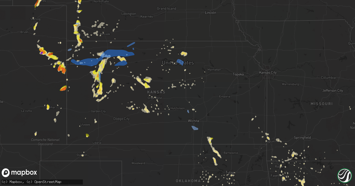
Hail Map in Kansas on July 2, 2020
Get this storm
July 2 map
$229
one time, instant access
Download today. No call, no setup
Keep the $229
Bought the map and want the full workflow? Apply the entire $229 to a subscription within 7 days. None of it is wasted.
Every map, not just this one
This buys you this map. Subscription and you get every map we run, in the markets you choose from a few cities to whole states to nationwide. Plus real-time alerts the moment a storm fires.
Contact data
Name, contact info, occupancy, even credit band for addresses in the footprint. You go from where it hit to who to call.
Become the source they trust
Unlimited branding weather history reports on demand. You already have the documented answer ready for the property owner, and you are the one who showed up with it.
Property data and RoofTrace estimates
Pull up any address you have got, its value and the exact code rules for that jurisdiction, straight from One Click Code. Then RoofTrace estimates the squares, pitch, and roof value, priced the way you price.
Storm reports in Kansas
Kansas
| Date | Description |
|---|---|
| 07/02/20206:54 PM CDT | 3 power poles reported down due to winds. Time radar estimated. |
| 07/02/20206:53 PM CDT | Report via local law enforcement. Pea size hail reported with winds estimated 60-70 mph. |
| 07/02/20206:50 PM CDT | Linear irrigation system blown over at ksu research center. |
| 07/02/20206:50 PM CDT | From ksu mesonet site. Estimated time of report based on damage report. |
| 07/02/20206:45 PM CDT | A local report indicates 63 MPH wind near 6 N BREWSTER |
| 07/02/20206:42 PM CDT | Hail reported ranged from dime size to 1.5 in. |
| 07/02/20206:39 PM CDT | A local report indicates 63 MPH wind near 7 N LUDELL |
| 07/02/20206:34 PM CDT | 2 to 3 inch tree limbs were downed. |
| 07/02/20206:32 PM CDT | A local report indicates 1.00 inch wind near OAKLEY |
| 07/02/20206:28 PM CDT | A local report indicates 1.25 inch wind near OAKLEY |
| 07/02/20206:25 PM CDT | Electric line blown down. |
| 07/02/20206:16 PM CDT | A local report indicates 1.75 inch wind near 3 WNW MANNING |
| 07/02/20206:15 PM CDT | Corrects previous dust storm report from oakley. Blowing dust reported with brownout conditions. Winds estimated @ 50-60 mph. |
| 07/02/20206:08 PM CDT | Asos station kgld goodland. |
| 07/02/20206:07 PM CDT | Estimated 60-70 mph wind gust. |
| 07/02/20206:05 PM CDT | Time estimated based on radar. |
| 07/02/20205:45 PM CDT | A local report indicates 1.25 inch wind near 17 N BIRD CITY |
| 07/02/20205:44 PM CDT | A local report indicates 1.00 inch wind near 4 WSW MANNING |
| 07/02/20205:39 PM CDT | A local report indicates 62 MPH wind near TRIBUNE |
| 07/02/20205:34 PM CDT | Mesonet station cw6099 9 sse sharon springs. |
| 07/02/20205:30 PM CDT | A local report indicates 1.00 inch wind near 6 NNW MANNING |
| 07/02/20205:01 PM CDT | One barn and the sides of another barn blown down on ballard ave southwest of baxter springs. |
| 07/02/20206:21 AM CDT | At 1120 PM CDT, severe thunderstorms were located along a line extending from near Chester to 5 miles east of Aurora to 4 miles east of Salina, moving east at 35 mph. HAZARD...60 mph wind gusts. SOURCE...Trained weather spotters. A 66 MPH wind gust was reported at the Salina Airport at 1105 PM. IMPACT...Expect damage to roofs, siding, and trees. Locations impacted include... Abilene, Clay Center, Solomon, Enterprise, Clyde, Clifton, Miltonvale, Linn, Morganville, Cuba, Morrowville, Palmer, Haddam, Munden, Manchester, Narka, Mahaska, Longford, Agenda and Vining.This includes Interstate 70 between mile markers 267 and 281. |
| 07/02/20206:19 AM CDT | At 1118 PM CDT, severe thunderstorms were located along a line extending from 5 miles north of Minneapolis to near Smolan to near Geneseo, moving east at 55 mph. HAZARD...60 mph wind gusts. SOURCE...Radar indicated. IMPACT...Expect damage to roofs, siding, and trees. Locations impacted include... Salina, Mcpherson, Lindsborg, Galva, Canton, Marquette, Assaria, Gypsum, Brookville, Smolan, New Cambria, Falun, Glendale, Salina Airport, Roxbury, Bridgeport, Kipp, Kanopolis Lake and Kanopolis State Park.This includes the following highways... Interstate 135 between Mile Markers 62 and 95. Interstate 70 between Mile Markers 236 and 266. |
| 07/02/20205:52 AM CDT | At 1051 PM CDT, severe thunderstorms were located along a line extending from near Hardy to 7 miles south of Concordia to 3 miles east of Brookville, moving east at 35 mph. HAZARD...60 mph wind gusts and penny size hail. SOURCE...Radar indicated. IMPACT...Expect damage to roofs, siding, and trees. Locations impacted include... Belleville, Scandia, Courtland, Norway and Republic. |
| 07/02/20205:45 AM CDT | At 1044 PM CDT, a severe thunderstorm was located near Great Bend, moving southeast at 20 mph. HAZARD...60 mph wind gusts and penny size hail. SOURCE...Radar indicated. IMPACT...Expect damage to roofs, siding, and trees. Locations impacted include... Great Bend, Ellinwood, Pawnee Rock, Albert, Great Bend Airport and Cheyenne Bottoms. |
| 07/02/20205:42 AM CDT | At 1042 PM CDT, severe thunderstorms were located along a line extending from near Jamestown to 8 miles southwest of Concordia to near Brookville, moving east at 35 mph. HAZARD...60 mph wind gusts and penny size hail. SOURCE...Radar indicated. IMPACT...Expect damage to roofs, siding, and trees. Locations impacted include... Concordia, Minneapolis, Bennington, Miltonvale, Glasco, Delphos, Tescott, Jamestown, Culver, Wells, Aurora and Ada. |
| 07/02/20205:30 AM CDT | At 1030 PM CDT, a severe thunderstorm was located 8 miles southeast of Sylvan Grove, or 10 miles southwest of Lincoln, moving east at 35 mph. HAZARD...60 mph wind gusts and penny size hail. SOURCE...60 mph winds have been reported in Sylvan Grove. IMPACT...Expect damage to roofs, siding, and trees. Locations impacted include... Ellsworth, Wilson, Kanopolis, Lincoln, Holyrood, Sylvan Grove, Beverly, Lorraine, Barnard, Ash Grove, Westfall, Ellsworth Airport, Kanopolis Lake and Kanopolis State Park.This includes Interstate 70 between Mile Markers 206 and 235. |
| 07/02/20205:10 AM CDT | At 1010 PM CDT, a severe thunderstorm was located near Russell, moving east at 35 mph. HAZARD...60 mph wind gusts and penny size hail. SOURCE...68 mph winds have been reported at the Russell Airport. IMPACT...Expect damage to roofs, siding, and trees. Locations impacted include... Russell, Hoisington, Wilson, Claflin, Lucas, Gorham, Luray, Dorrance, Olmitz, Milberger, Bunker Hill, Paradise, Galatia, Susank, Waldo, Russell Airport, Wilson State Park, Wilson Lake and Odin.This includes Interstate 70 between Mile Markers 176 and 205. |
| 07/02/20205:02 AM CDT | At 1001 AM CDT, a severe thunderstorm was located near Dexter, or 11 miles west of Cedar Vale, moving southeast at 15 mph. HAZARD...60 mph wind gusts and quarter size hail. SOURCE...Radar indicated. IMPACT...Hail damage to vehicles is expected. Expect wind damage to roofs, siding, and trees. Locations impacted include... Cedar Vale, Dexter and Maple City. |
| 07/02/20204:43 AM CDT | At 943 PM CDT, severe thunderstorms were located along a line extending from 9 miles southeast of Bellaire to 6 miles northwest of Tipton to 7 miles southwest of Luray, moving east at 55 mph. HAZARD...70 mph wind gusts. SOURCE...Trained weather spotters. IMPACT...Expect considerable tree damage. Damage is likely to mobile homes, roofs, and outbuildings. Locations impacted include... Beloit, Osborne, Downs, Cawker City, Glen Elder, Jewell, Natoma, Tipton, Gaylord, Alton, Portis, Asherville, Simpson, Ionia, Randall, Hunter, Scottsville, Harlan and Victor.People attending Waconda Lake, and Downs should seek safe shelterimmediately! |
| 07/02/20204:38 AM CDT | At 936 PM CDT, severe thunderstorms were located along a line extending from 8 miles northwest of Luray to 6 miles east of Pfeifer, moving east at 45 mph. HAZARD...65 mph wind gusts. SOURCE...63 mph winds have been reported at the Russell Airport. IMPACT...Expect damage to roofs, siding, and trees. Locations impacted include... Ellsworth, Wilson, Kanopolis, Lincoln, Holyrood, Sylvan Grove, Geneseo, Beverly, Lorraine, Barnard, Ash Grove, Westfall, Ellsworth Airport, Kanopolis Lake and Kanopolis State Park.This includes Interstate 70 between Mile Markers 206 and 235. |
| 07/02/20204:17 AM CDT | At 917 PM CDT, a severe thunderstorm was located very near Catherine, moving east at 30 mph. HAZARD...60 mph wind gusts and quarter size hail. SOURCE...Radar indicated. IMPACT...Hail damage to vehicles is expected. Expect wind damage to roofs, siding, and trees. Locations impacted include... Hays, Victoria, Walker, Catherine, Emmeram, Yocemento, Toulon, Munjor and Antonino. |
| 07/02/20204:12 AM CDT | At 911 PM CDT, a severe thunderstorm was located 8 miles south of Zurich, or 14 miles north of Yocemento, moving east at 35 mph. HAZARD...60 mph wind gusts. Wind gusts will preceed the main thunderstorm by at least 30 mins. SOURCE...Radar indicated. IMPACT...Expect damage to roofs, siding, and trees. Locations impacted include... Russell, Lucas, Gorham, Luray, Dorrance, Milberger, Bunker Hill, Paradise, Waldo, Wilson State Park, Wilson Lake and Russell Airport.This includes Interstate 70 between Mile Markers 176 and 204. |
| 07/02/20204:01 AM CDT | At 901 PM CDT, a severe thunderstorm was located near Ransom, moving east at 30 mph. HAZARD...60 mph wind gusts and nickel size hail. SOURCE...Radar indicated. IMPACT...Expect damage to roofs, siding, and trees. Locations impacted include... Ransom, McCracken, Brownell, Trego Center, Cedar Bluff and Arnold. |
| 07/02/20203:54 AM CDT | At 854 PM CDT, severe thunderstorms were located along a line extending from near Funk to 6 miles north of Athol to near Natoma, moving east at 50 mph. HAZARD...60 mph wind gusts. SOURCE...Radar indicated. IMPACT...Expect damage to roofs, siding, and trees. Locations impacted include... Phillipsburg, Plainville, Smith Center, Osborne, Stockton, Alma, Red Cloud, Franklin, Blue Hill, Downs, Mankato, Kensington, Cawker City, Glen Elder, Jewell, Orleans, Campbell, Natoma, Palco and Agra.People attending Waconda Lake, and Downs should seek safe shelterimmediately! |
| 07/02/20203:38 AM CDT | At 837 PM CDT, a line of severe thunderstorms was located from 12 miles north of Ellis to near Ellis, moving east at 35 mph. HAZARD...70 mph wind gusts and penny size hail. SOURCE...Radar indicated. IMPACT...Expect considerable tree damage. Damage is likely to mobile homes, roofs, and outbuildings. Locations impacted include... Hays, Ellis, Wakeeney, Victoria, Walker, Catherine, Ogallah, Emmeram, Yocemento, Riga and Toulon. |
| 07/02/20203:27 AM CDT | At 827 PM CDT, a severe thunderstorm was located near Pfeifer, moving north at 5 mph. HAZARD...60 mph wind gusts and quarter size hail. SOURCE...Radar indicated. IMPACT...Hail damage to vehicles is expected. Expect wind damage to roofs, siding, and trees. Locations impacted include... Victoria, Walker and Pfeifer. |
| 07/02/20203:27 AM CDT | At 827 PM CDT, severe thunderstorms were located along a line extending from Almena to Bogue, moving northeast at 45 mph. HAZARD...70 mph wind gusts and penny size hail. SOURCE...Trained weather spotters. IMPACT...Expect considerable tree damage. Damage is likely to mobile homes, roofs, and outbuildings. Locations impacted include... Norton, Hill City, Almena, Bogue, Nicodemus, Edmond and Densmore. |
| 07/02/20203:19 AM CDT | At 819 PM CDT, a severe thunderstorm was located near Great Bend, moving northwest at 10 mph. HAZARD...60 mph wind gusts and quarter size hail. SOURCE...Radar indicated. IMPACT...Hail damage to vehicles is expected. Expect wind damage to roofs, siding, and trees. Locations impacted include... Great Bend, Hoisington, Albert, Olmitz, Galatia, Susank, Great Bend Airport and Cheyenne Bottoms. |
| 07/02/20202:24 AM CDT | At 724 PM CDT, severe thunderstorms were located along a line extending from Oberlin to 7 miles west of Hoxie, moving east at 40 mph. HAZARD...70 mph wind gusts and quarter size hail. SOURCE...Radar indicated. IMPACT...Hail damage to vehicles is expected. Expect considerable tree damage. Wind damage is also likely to mobile homes, roofs, and outbuildings. Locations impacted include... Norton, Hill City, Almena, Lenora, Morland, Bogue and Clayton. |
| 07/02/20202:21 AM CDT | At 720 PM CDT, severe thunderstorms were located along a line extending from near Curtis to near Indianola to near Hoxie, moving east at 40 mph. HAZARD...60 mph wind gusts and nickel size hail. SOURCE...Trained weather spotters. IMPACT...Expect damage to roofs, siding, and trees. Locations impacted include... Cambridge, Arapahoe, Elwood, Beaver City, Holbrook, Edison, Wilsonville, Smithfield, Hendley, Hollinger and Johnson Lake. |
| 07/02/20201:44 AM CDT | At 643 PM CDT, a severe thunderstorm was located 10 miles north of Walnut, or 13 miles northeast of Erie, moving southwest at 5 mph. HAZARD...60 mph wind gusts and quarter size hail. SOURCE...Radar indicated. IMPACT...Hail damage to vehicles is expected. Expect wind damage to roofs, siding, and trees. Locations impacted include... Erie, Savonburg, Elsmore and Stark. |
| 07/02/20201:34 AM CDT | At 633 PM CDT, a severe thunderstorm was located near Moscow, moving north at 20 mph. HAZARD...60 mph wind gusts and half dollar size hail. SOURCE...Radar indicated. IMPACT...Hail damage to vehicles is expected. Expect wind damage to roofs, siding, and trees. Locations impacted include... Moscow and Cave. |
| 07/02/20201:29 AM CDT | Personal weather station measured gust. |
| 07/02/20201:08 AM CDT | At 608 PM CDT, a severe thunderstorm was located 7 miles south of Monument, or 12 miles southwest of Oakley, moving north at 25 mph. HAZARD...60 mph wind gusts and quarter size hail. SOURCE...Radar indicated. IMPACT...Hail damage to vehicles is expected. Expect wind damage to roofs, siding, and trees. Locations impacted include... Oakley and Monument. This includes Interstate 70 in Kansas between mile markers 64 and 80. |
| 07/02/20201:04 AM CDT | Measured at eisenhower national. |
| 07/02/20201:02 AM CDT | At 601 PM CDT, a severe thunderstorm was located over Pretty Prairie, and is moving west at 5 mph. HAZARD...60 mph wind gusts and quarter size hail. SOURCE...Radar indicated. IMPACT...Hail damage to vehicles is expected. Expect wind damage to roofs, siding, and trees. Locations impacted include... Pretty Prairie, Mt Vernon, Cheney State Park and Cheney Lake. |
| 07/02/202012:46 AM CDT | At 546 PM CDT, a severe thunderstorm was located near Manning, moving north at 15 mph. HAZARD...60 mph wind gusts and half dollar size hail. SOURCE...Radar indicated. IMPACT...Hail damage to vehicles is expected. Expect wind damage to roofs, siding, and trees. Locations impacted include... Grigston and Manning. |
| 07/02/202012:38 AM CDT | At 537 PM CDT, a severe thunderstorm was located 7 miles east of Scott State Lake, moving north at 25 mph. HAZARD...60 mph wind gusts and half dollar size hail. SOURCE...Radar indicated. IMPACT...Hail damage to vehicles is expected. Expect wind damage to roofs, siding, and trees. Locations impacted include... The Monument Rocks. |
| 07/02/202012:12 AM CDT | At 512 PM MDT/612 PM CDT/, severe thunderstorms were located along a line extending from 12 miles southeast of Bird City to 13 miles southeast of Goodland, moving east at 60 mph. HAZARD...70 mph wind gusts and quarter size hail. SOURCE...Radar indicated. IMPACT...Hail damage to vehicles is expected. Expect considerable tree damage. Wind damage is also likely to mobile homes, roofs, and outbuildings. Locations impacted include... Colby, Goodland, Brewster, Levant, Rexford, Gem and Menlo. This includes Interstate 70 in Kansas between mile markers 17 and 74. |
| 07/02/202012:07 AM CDT | At 507 PM CDT, a severe thunderstorm was located near Manning, moving north at 15 mph. HAZARD...60 mph wind gusts and half dollar size hail. SOURCE...Radar indicated. IMPACT...Hail damage to vehicles is expected. Expect wind damage to roofs, siding, and trees. Locations impacted include... Scott City, Grigston, Manning and Healy. |
| 07/02/202012:03 AM CDT | At 503 PM CDT, a severe thunderstorm was located near Modoc, moving north at 15 mph. HAZARD...60 mph wind gusts and half dollar size hail. SOURCE...Radar indicated. IMPACT...Hail damage to vehicles is expected. Expect wind damage to roofs, siding, and trees. Locations impacted include... Scott City, Scott State Lake and Modoc. |
| 07/01/202011:51 PM CDT | At 451 PM MDT/551 PM CDT/, severe thunderstorms were located along a line extending from 4 miles southeast of Wauneta to 13 miles southeast of St. Francis, moving east at 30 mph. HAZARD...70 mph wind gusts and half dollar size hail. SOURCE...Radar indicated. IMPACT...Hail damage to vehicles is expected. Expect considerable tree damage. Wind damage is also likely to mobile homes, roofs, and outbuildings. Locations impacted include... Atwood, Benkelman, Trenton, Culbertson, Bird City, Palisade and Stratton. |
| 07/01/202011:43 PM CDT | At 443 PM MDT/543 PM CDT/, a severe thunderstorm was located 7 miles northeast of Ruleton, moving southeast at 40 mph. HAZARD...70 mph wind gusts and penny size hail. SOURCE...Radar indicated. IMPACT...Expect considerable tree damage. Damage is likely to mobile homes, roofs, and outbuildings. Locations impacted include... Goodland, Ruleton and Edson. This includes Interstate 70 in Kansas between mile markers 2 and 29. |
| 07/01/202011:39 PM CDT | At 439 PM MDT, a severe thunderstorm was located near Sharon Springs, moving northeast at 40 mph. HAZARD...70 mph wind gusts and penny size hail. SOURCE...Radar indicated. IMPACT...Expect considerable tree damage. Damage is likely to mobile homes, roofs, and outbuildings. Locations impacted include... Sharon Springs, Weskan and Wallace. |
| 07/01/202011:20 PM CDT | Delayed report from july 2. Dispatch reported strong wind in town and a tree down. Time estimated. |
| 07/01/202011:12 PM CDT | At 412 PM MDT/512 PM CDT/, a severe thunderstorm was located 5 miles southeast of Haigler, or 12 miles north of St. Francis, moving east at 25 mph. HAZARD...70 mph wind gusts and quarter size hail. SOURCE...Radar indicated. IMPACT...Hail damage to vehicles is expected. Expect considerable tree damage. Wind damage is also likely to mobile homes, roofs, and outbuildings. Locations impacted include... St. Francis, Benkelman, Bird City, Haigler, Parks and Wheeler. |
| 07/01/202011:12 PM CDT | A local report indicates 66 MPH wind near SALINA |
| 07/01/202010:49 PM CDT | A local report indicates 60 MPH wind near CULVER |
| 07/01/202010:46 PM CDT | At 346 PM MDT, a severe thunderstorm was located 7 miles southwest of Wray, moving east at 25 mph. HAZARD...Golf ball size hail and 60 mph wind gusts. SOURCE...Radar indicated. IMPACT...People and animals outdoors will be injured. Expect hail damage to roofs, siding, windows, and vehicles. Expect wind damage to roofs, siding, and trees. Locations impacted include... Wray, Laird and Vernon. This includes Highway 385 between mile markers 229 and 249. |
| 07/01/202010:39 PM CDT | Delayed report from july 2. Several decent size branches reported down in town. Time estimated based on radar. |
| 07/01/202010:19 PM CDT | Delayed report. Several medium size tree branches down in the area. Time estimated based on other reports in the area. |
| 07/01/202010:19 PM CDT | . |
| 07/01/202010:11 PM CDT | Report from mping: 1-inch tree limbs broken; shingles blown off. |
| 07/01/202010:01 PM CDT | At 300 PM MDT, a severe thunderstorm was located 8 miles northeast of Sheridan Lake, or 17 miles southeast of Cheyenne Wells, moving north at 10 mph. HAZARD...Ping pong ball size hail and 60 mph wind gusts. SOURCE...Radar indicated. IMPACT...People and animals outdoors will be injured. Expect hail damage to roofs, siding, windows, and vehicles. Expect wind damage to roofs, siding, and trees. Locations impacted include... Weskan and Arapahoe. This includes Highway 385 near mile marker 136. |
| 07/01/20209:41 PM CDT | Winds blowing dust and dirt 5 to 8 ft high. |
| 07/01/20209:41 PM CDT | Measured at the russell airport. |
| 07/01/20209:40 PM CDT | Delayed report...mesonet station up823 2.4 w bunker hill |
| 07/01/20209:34 PM CDT | Measured at russell airport. |
| 07/01/20209:30 PM CDT | Mesasured wind at russell airport. |
| 07/01/20209:04 PM CDT | A local report indicates 63 MPH wind near 2 NNW PORTIS |
| 07/01/20209:04 PM CDT | A local report indicates 61 MPH wind near 5 NE ALTON |
| 07/01/20208:56 PM CDT | Measured gust of 68 mph at a mesonet site. |
| 07/01/20208:54 PM CDT | Measured gusts by storm chaser...report relayed by nws omaha. |
| 07/01/20208:51 PM CDT | A local report indicates 63 MPH wind near PHILLIPSBURG AIRPORT |
| 07/01/20208:45 PM CDT | Tree down on 30 rd between e and f roads. |
| 07/01/20208:41 PM CDT | A local report indicates 59 MPH wind near 9 N STOCKTON |
| 07/01/20208:38 PM CDT | A local report indicates 60 MPH wind near 4 WNW NICODEMUS |
| 07/01/20208:24 PM CDT | A local report indicates 58 MPH wind near 1 SE PALCO |
| 07/01/20208:15 PM CDT | A local report indicates 67 MPH wind near 1 W LOGAN |
| 07/01/20208:12 PM CDT | A local report indicates 75 MPH wind near BOGUE |
| 07/01/20208:09 PM CDT | A local report indicates 88 MPH wind near 4 WNW NICODEMUS |
| 07/01/20208:05 PM CDT | Several tree limbs blown down with largest limb measuring 4 inches in diameter. |
| 07/01/20208:05 PM CDT | A local report indicates 58 MPH wind near 1 NNW NORTON |
| 07/01/20208:02 PM CDT | A local report indicates 93 MPH wind near 1 NE HILL CITY |
| 07/01/20208:02 PM CDT | Numerous tree limbs and powerlines down resulting in power loss. 4 tank batteries |
| 07/01/20207:44 PM CDT | A local report indicates 72 MPH wind near 2 NNE NEW ALMELO |
| 07/01/20207:44 PM CDT | A local report indicates 60 MPH wind near MORLAND |
| 07/01/20207:39 PM CDT | A local report indicates 65 MPH wind near 1 WNW HOXIE |
| 07/01/20207:30 PM CDT | A local report indicates 60 MPH wind near 5 SSW NEW ALMELO |
| 07/01/20207:29 PM CDT | A local report indicates 65 MPH wind near 6 S HOXIE |
| 07/01/20207:19 PM CDT | A local report indicates 62 MPH wind near 3 ENE GOVE |
| 07/01/20207:13 PM CDT | A local report indicates 68 MPH wind near 5 S SELDEN |
| 07/01/20207:12 PM CDT | Winds were unknown but blew away a trampoline and some planter boxes. |
All States Impacted by Hail Map on July 2, 2020
Cities Impacted by Hail Map on July 2, 2020
- Monett, MO
- Burlington, CO
- Valentine, NE
- Alpena, AR
- Little Rock, AR
- Coldwater, MS
- Medway, ME
- Hays, KS
- Lake Village, AR
- Presho, SD
- Vivian, SD
- Scott City, KS
- Arapahoe, CO
- Sheridan Lake, CO
- Richardton, ND
- Mud Butte, SD
- Faith, SD
- Wray, CO
- Wilmar, AR
- Lansford, ND
- Glenburn, ND
- Stark, KS
- Savonburg, KS
- Dover, AR
- Rocklake, ND
- Rolla, ND
- Hansboro, ND
- Dunn Center, ND
- Taylor, ND
- Halliday, ND
- Rapid City, SD
- St John, KS
- Dodd City, TX
- Windom, TX
- Bayard, NE
- Panhandle, TX
- Gurley, NE
- Peetz, CO
- Sidney, NE
- Deer, AR
- Parshall, ND
- Roseglen, ND
- Belleville, KS
- Scandia, KS
- Concordia, KS
- Jamestown, KS
- Kilgore, NE
- Nenzel, NE
- Oakley, KS
- Hanston, KS
- Kinsley, KS
- Saint James, MO
- Chandler, OK
- Perryville, AR
- Fort Worth, TX
- Gregory, SD
- Bethune, CO
- Carl Junction, MO
- Joplin, MO
- Webb City, MO
- Monticello, AR
- Grady, AR
- Fairfax, OK
- Pierce City, MO
- Hill City, SD
- Keystone, SD
- Goodland, KS
- Clarksville, AR
- Lamar, AR
- Prairie City, SD
- Cope, CO
- Anton, CO
- Buena Vista, GA
- Union Center, SD
- Newell, SD
- Bird City, KS
- Saint Francis, KS
- Benkelman, NE
- Gladstone, ND
- Hemingford, NE
- Lamar, CO
- Wiley, CO
- Hasty, CO
- McClave, CO
- Harvey, ND
- Chaseley, ND
- Bowdon, ND
- Burr Oak, KS
- Tupelo, OK
- De Witt, AR
- Greenville, MS
- Leland, MS
- Bentonia, MS
- Newcastle, WY
- Hermosa, SD
- Oberon, ND
- Springdale, AR
- Oral, SD
- Pine Ridge, SD
- Champion, NE
- Carpio, ND
- Salina, KS
- Alexander, AR
- Mabelvale, AR
- Bauxite, AR
- Howes, SD
- Pierre, SD
- Blunt, SD
- Guide Rock, NE
- Searcy, AR
- Hugo, OK
- Rison, AR
- Lake Wales, FL
- Atwood, KS
- Selden, KS
- Hoxie, KS
- Rexford, KS
- Lexington, MS
- Cruger, MS
- Sturgis, SD
- Mulberry, AR
- Ryan, OK
- Crawford, NE
- Dumas, AR
- Healy, KS
- Grinnell, KS
- Ogallala, NE
- Paxton, NE
- Keystone, NE
- Harrison, AR
- Rolette, ND
- Rugby, ND
- White Owl, SD
- Whitman, NE
- Max, NE
- Lincoln, KS
- Sylvan Grove, KS
- Drumright, OK
- Dresden, KS
- Yale, OK
- Regent, ND
- Hettinger, ND
- Colby, KS
- Garden City, KS
- Leslie, AR
- Dickinson, ND
- New England, ND
- Amidon, ND
- Midland, SD
- Draper, SD
- Fort Pierre, SD
- Okaton, SD
- Murdo, SD
- Hayes, SD
- Satanta, KS
- Berthold, ND
- Lindsborg, KS
- Assaria, KS
- Reva, SD
- Edson, KS
- Utica, KS
- Hominy, OK
- Vale, SD
- Madison, ME
- Sarah, MS
- Crenshaw, MS
- Indianola, MS
- Hollandale, MS
- Inverness, MS
- Stratton, CO
- Cody, NE
- Tuthill, SD
- Saint Francis, SD
- Aladdin, WY
- Marsland, NE
- Rogers, AR
- Yazoo City, MS
- Glenpool, OK
- Phillips, WI
- Lebanon, NE
- Shaw, MS
- Doddsville, MS
- Kensal, ND
- Booneville, AR
- Ponca, AR
- Garfield, KS
- Belpre, KS
- Larned, KS
- Guymon, OK
- Chamberlain, SD
- England, AR
- Pine Bluff, AR
- Cherry Creek, SD
- Philip, SD
- Milesville, SD
- Miller, SD
- Lakin, KS
- Belzoni, MS
- Crookston, NE
- Shell Knob, MO
- Washburn, ND
- Hayes Center, NE
- Mountain View, AR
- Magazine, AR
- Thedford, NE
- Pawhuska, OK
- Shidler, OK
- Burbank, OK
- Granada, CO
- Berryville, AR
- Hudson, KS
- Maple City, KS
- Dexter, KS
- Herndon, KS
- Hernando, MS
- Lyon, MS
- Clarksdale, MS
- Silver City, MS
- Hudson, ME
- Spencer, NE
- Oneill, NE
- Waxahachie, TX
- Cedar Hill, TX
- Midlothian, TX
- McIntosh, SD
- McLaughlin, SD
- Kanorado, KS
- Victoria, KS
- Walker, KS
- Gorham, KS
- Wood, SD
- Tulsa, OK
- Sapulpa, OK
- Sand Springs, OK
- Belleville, AR
- Danville, AR
- Plaza, ND
- Ryder, ND
- Killdeer, ND
- Green Forest, AR
- Abilene, KS
- Solomon, KS
- Minter City, MS
- Charleston, MS
- Akron, CO
- Bolton, MS
- Wasta, SD
- Enning, SD
- Winner, SD
- Hamill, SD
- Wauneta, NE
- Stratton, NE
- Oxford, MS
- Water Valley, MS
- Tutwiler, MS
- Imperial, NE
- Enders, NE
- Superior, NE
- Dundee, MS
- Sledge, MS
- Isola, MS
- Mankato, KS
- Yellville, AR
- Caputa, SD
- Holdenville, OK
- Wetumka, OK
- Parthenon, AR
- Woodworth, ND
- Sheridan, AR
- Warren, AR
- Elkhart, KS
- Jenks, OK
- Pittsboro, MS
- Tillar, AR
- Perth, ND
- Vernon, CO
- Weskan, KS
- Parks, NE
- Sterling, CO
- Kress, TX
- Red Oak, TX
- Otis, KS
- Pfeifer, KS
- Russell, KS
- Jetmore, KS
- Ellis, KS
- Scenic, SD
- New Salem, ND
- Dighton, KS
- Milburn, OK
- Kenefic, OK
- Brewster, KS
- Eagle Butte, SD
- Dupree, SD
- Lantry, SD
- Gove, KS
- Aurora, MO
- Reeds Spring, MO
- Brinkley, AR
- Hamburg, AR
- Pittsburg, KS
- Asbury, MO
- Coleharbor, ND
- Milo, ME
- Seligman, MO
- Garfield, AR
- Eagle Rock, MO
- Keller, TX
- Elkins, AR
- Fayetteville, AR
- Weleetka, OK
- Bassett, NE
- Bridgeport, NE
- Angora, NE
- Batesville, AR
- Portales, NM
- Wessington Springs, SD
- Gypsum, KS
- Cape Fair, MO
- Beeler, KS
- Sterling, KS
- Omaha, AR
- Mounds, OK
- Pritchett, CO
- Okemah, OK
- Seminole, OK
- Sarcoxie, MO
- Selfridge, ND
- Mayersville, MS
- Carrington, ND
- Brownell, KS
- McCracken, KS
- Burdett, KS
- Cherokee, KS
- Weir, KS
- Cushing, OK
- Poteau, OK
- Meadow, SD
- Joes, CO
- Vona, CO
- Kirk, CO
- Senatobia, MS
- Coahoma, MS
- Gordon, NE
- Columbus, KS
- Hollister, MO
- Bisbee, ND
- Knox, ND
- Hugoton, KS
- Moscow, KS
- Glencoe, OK
- Sarles, ND
- Lefor, ND
- Kinta, OK
- Park, KS
- Quinter, KS
- Wisner, LA
- Morland, KS
- Denhoff, ND
- Goodrich, ND
- Merigold, MS
- Ruleville, MS
- Cleveland, MS
- Ferriday, LA
- Dardanelle, AR
- Sahuarita, AZ
- Hazen, ND
- Stanton, ND
- Culbertson, NE
- Carthage, MO
- Reeds, MO
- Bixby, OK
- Stuart, NE
- Lenora, KS
- Stillwater, OK
- Mccurtain, OK
- Great Bend, KS
- Jefferson, AR
- Penokee, KS
- Hill City, KS
- Huntsville, AR
- Harmony, ME
- Hunter, KS
- Belcourt, ND
- Curtis, NE
- Snow Lake, AR
- Watson, AR
- Merriman, NE
- Lodgepole, SD
- Hagarville, AR
- Altus, AR
- Ozark, AR
- Hartman, AR
- Houlton, ME
- Cassville, MO
- Carson, ND
- Uniontown, KS
- Golden, MO
- Bisbee, AZ
- Tombstone, AZ
- Thorndike, ME
- Troy, ME
- Harrison, NE
- Oark, AR
- Redfield, AR
- Madrid, NE
- Galena, MO
- Potter, NE
- Portis, KS
- Oronogo, MO
- Paris, AR
- Claude, TX
- Troy, NY
- Dalton, NE
- Eustis, NE
- Lowell, AR
- Stafford, KS
- Lewis, KS
- Macksville, KS
- Branson, MO
- Okmulgee, OK
- Gann Valley, SD
- Downs, KS
- Long Pine, NE
- Dustin, OK
- Belvidere, SD
- Winona, KS
- Monument, KS
- Marienthal, KS
- Holly, CO
- Ruso, ND
- Benedict, ND
- Grant, NE
- Bingham, ME
- Ralston, OK
- Buffalo, SD
- Duncan, MS
- Anderson, MO
- Pineville, MO
- Bristow, OK
- Valley Springs, AR
- Lampe, MO
- Anson, ME
- Newton, KS
- Mylo, ND
- Fairfield, ME
- Gainesville, MO
- Wing, ND
- Galena, KS
- Ponca City, OK
- Martin, SD
- Stuart, FL
- Indiantown, FL
- Osborne, KS
- Cuba, MO
- Pawnee, OK
- Benton, AR
- Ellinwood, KS
- Portland, AR
- Waterford, NY
- Mechanicville, NY
- Beloit, KS
- Tribune, KS
- Elgin, ND
- Ulysses, KS
- Sublette, KS
- Kingsland, AR
- Bearden, AR
- Sherman, ME
- Eureka Springs, AR
- Plainview, AR
- Humphrey, AR
- Louise, MS
- Anguilla, MS
- Wall, SD
- Marietta, OK
- Waterville, ME
- Chapman, KS
- Saint Bernard, LA
- Helena, AR
- Drew, MS
- Scranton, AR
- Turtle Lake, ND
- Ripley, OK
- Beggs, OK
- Pea Ridge, AR
- Oviedo, FL
- Orlando, FL
- Minneapolis, KS
- Grapevine, AR
- Island Falls, ME
- Wasola, MO
- Glen Allan, MS
- Chatham, MS
- McCook, NE
- Maywood, NE
- Mansfield, TX
- Girard, KS
- Maypearl, TX
- Venus, TX
- Napoleon, ND
- Lamar, OK
- Barnard, KS
- Jasper, AR
- Perkins, OK
- Coalgate, OK
- Athens, ME
- Sundance, WY
- Marble Falls, AR
- Marks, MS
- Shelby, MS
- Mound Bayou, MS
- Hindsville, AR
- Tryon, OK
- Brookston, TX
- Moundridge, KS
- Ransom, KS
- Miami, OK
- Kingston, AR
- Roxton, TX
- Milford, KS
- Bradford, AR
- Saint Lawrence, SD
- Johnson, KS
- Chadwick, MO
- Almont, ND
- Hurdsfield, ND
- Makoti, ND
- Plainville, KS
- Langdon, ND
- Barnsdall, OK
- White Hall, AR
- Ivan, AR
- Pingree, ND
- Pleasant Grove, AR
- Ennis, TX
- Hensley, AR
- Prosper, TX
- Oberlin, KS
- Red Rock, OK
- Como, MS
- North Anson, ME
- Chestnutridge, MO
- Walnut Shade, MO
- Hanna, OK
- Brookville, KS
- New Underwood, SD
- Newport, AR
- Verona, MO
- Purdy, MO
- Esbon, KS
- Augusta, AR
- Fort Lauderdale, FL
- Fordyce, AR
- Gould, AR
- Sicily Island, LA
- Flippin, AR
- Compton, AR
- Waldron, AR
- Wapanucka, OK
- Pickens, AR
- Bartley, NE
- Indianola, NE
- Hermleigh, TX
- Holyrood, KS
- Claflin, KS
- Freistatt, MO
- Gunnison, MS
- Fairfax, SD
- Butte, NE
- Washburn, MO
- Banks, AR
- Whitney, NE
- Clinton, AR
- Cooper, TX
- Gentry, AR
- Cave City, AR
- Trenton, NE
- Regan, ND
- Red Oak, OK
- Ethel, AR
- Canton, MS
- Heavener, OK
- Howe, OK
- Lancaster, TX
- Noel, MO
- Tolley, ND
- Gravette, AR
- Tucker, AR
- Black Hawk, SD
- Mercer, ND
- Natoma, KS
- Bogalusa, LA
- Woodbine, KS
- Burden, KS
- Winfield, KS
- Tipton, KS
- Pomona, MO
- Wesley, AR
- Sherrill, AR
- Sumner, TX
- Piedmont, SD
- Reliance, SD
- Broken Arrow, OK
- Coal Hill, AR
- Ellsworth, KS
- Dallas, TX
- Duncanville, TX
- Deadwood, SD
- Muenster, TX
- Solon, ME
- Allen, OK
- Protem, MO
- Silverton, TX
- Oacoma, SD
- New Edinburg, AR
- Gassville, AR
- Mission, SD
- Moro, AR
- Sylvia, KS
- Kanopolis, KS
- Erie, KS
- Agra, OK
- Benedicta, ME
- Kiefer, OK
- Abbyville, KS
- Plevna, KS
- Mount Vernon, AR
- Lebanon, KS
- Subiaco, AR
- Keldron, SD
- Holly Grove, AR
- Muleshoe, TX
- Havana, AR
- New Blaine, AR
- Oak Grove, LA
- Arlington, KS
- Turon, KS
- Magee, MS
- Mount Olive, MS
- Palmer, TX
- Ferris, TX
- New Braintree, MA
- Barre, MA
- Oakham, MA
- Jennings, KS
- Gem, KS
- Logan, KS
- Norcatur, KS
- Clayton, KS
- Levant, KS
- Norton, KS
- Long Island, KS
- Prairie View, KS
- Almena, KS
- Delphos, KS
- Glasco, KS
- Halstead, KS
- Sedgwick, KS
- Haysville, KS
- Belle Plaine, KS
- Mulvane, KS
- Derby, KS
- Peck, KS
- Dodge, ND
- Max, ND
- Minot Afb, ND
- Westhope, ND
- Burlington, ND
- Maxbass, ND
- Minot, ND
- Lincoln, MA
- Waltham, MA
- Weston, MA
- Custer, SD


