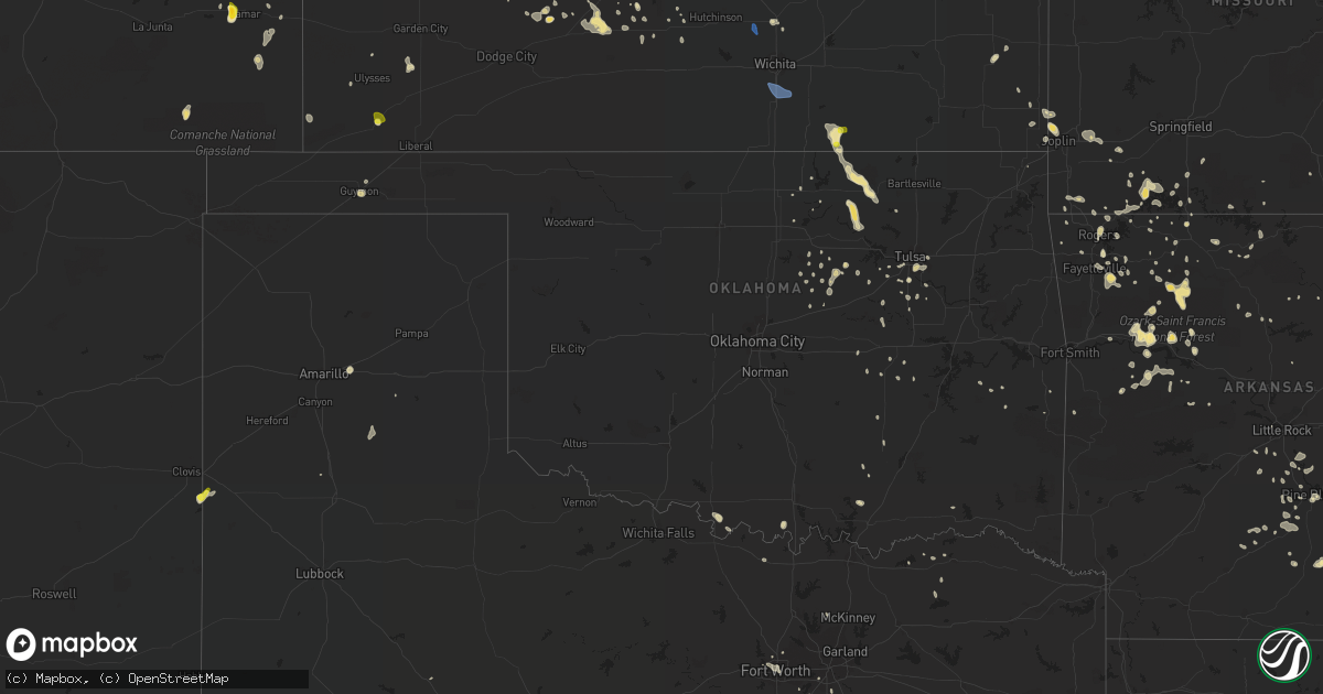
Hail Map in Oklahoma on July 2, 2020
Get this storm
July 2 map
$229
one time, instant access
Download today. No call, no setup
Keep the $229
Bought the map and want the full workflow? Apply the entire $229 to a subscription within 7 days. None of it is wasted.
Every map, not just this one
This buys you this map. Subscription and you get every map we run, in the markets you choose from a few cities to whole states to nationwide. Plus real-time alerts the moment a storm fires.
Contact data
Name, contact info, occupancy, even credit band for addresses in the footprint. You go from where it hit to who to call.
Become the source they trust
Unlimited branding weather history reports on demand. You already have the documented answer ready for the property owner, and you are the one who showed up with it.
Property data and RoofTrace estimates
Pull up any address you have got, its value and the exact code rules for that jurisdiction, straight from One Click Code. Then RoofTrace estimates the squares, pitch, and roof value, priced the way you price.
Storm reports in Oklahoma
Oklahoma
| Date | Description |
|---|---|
| 07/02/20206:45 PM CDT | A local report indicates 64 MPH wind near 2 SE BURNEYVILLE |
| 07/02/20205:33 PM CDT | Power pole was knocked down near main and the railroad crossing south of the court house. |
| 07/02/202012:56 PM CDT | Power lines down near highway 412 and 209th w ave |
| 07/02/202011:33 AM CDT | Raws site pwko2 measured peak gust to 58 mph. Time estimated from radar. |
| 07/01/202011:18 PM CDT | At 417 PM CDT, a severe thunderstorm was located over southeastern Joplin, moving southeast at 10 mph. HAZARD...60 mph wind gusts and quarter size hail. SOURCE...Radar indicated. IMPACT...Hail damage to vehicles is expected. Expect wind damage to roofs, siding, and trees. Locations impacted include... Joplin... Carthage... Webb City... Carl Junction... Galena... Oronogo... Granby... Carterville... Duquesne... Duenweg... Diamond... Loma Linda... Airport Drive... Leawood... Silver Creek... Alba... Purcell... Shoal Creek Drive... Saginaw... Carytown...This includes the following highways... Interstate 44 between mile markers 0 and 24. Interstate 49 between mile markers 26 and 47. |
| 07/01/20208:42 PM CDT | At 141 PM CDT, severe thunderstorms were located along a line extending from 2 miles south of Catoosa to 4 miles south of Glenpool to 3 miles northwest of Mounds, moving southeast at 20 mph. HAZARD...60 mph wind gusts. SOURCE...Radar indicated. IMPACT...Expect damage to roofs, siding, and trees. Locations in or near the path include... Tulsa... Broken Arrow... Bixby... Sapulpa... Jenks... Glenpool... Coweta... Catoosa... Inola... Kiefer... Beggs... Mounds... Kellyville... Jenks Riverside Airport... Oneta... Liberty... Hectorville... Leonard...This includes Interstate 44 between mile markers 202 and 206, betweenmile markers 208 and 212, and between mile markers 221 and 240. |
All States Impacted by Hail Map on July 2, 2020
Cities Impacted by Hail Map on July 2, 2020
- Monett, MO
- Burlington, CO
- Valentine, NE
- Alpena, AR
- Little Rock, AR
- Coldwater, MS
- Medway, ME
- Hays, KS
- Lake Village, AR
- Presho, SD
- Vivian, SD
- Scott City, KS
- Arapahoe, CO
- Sheridan Lake, CO
- Richardton, ND
- Mud Butte, SD
- Faith, SD
- Wray, CO
- Wilmar, AR
- Lansford, ND
- Glenburn, ND
- Stark, KS
- Savonburg, KS
- Dover, AR
- Rocklake, ND
- Rolla, ND
- Hansboro, ND
- Dunn Center, ND
- Taylor, ND
- Halliday, ND
- Rapid City, SD
- St John, KS
- Dodd City, TX
- Windom, TX
- Bayard, NE
- Panhandle, TX
- Gurley, NE
- Peetz, CO
- Sidney, NE
- Deer, AR
- Parshall, ND
- Roseglen, ND
- Belleville, KS
- Scandia, KS
- Concordia, KS
- Jamestown, KS
- Kilgore, NE
- Nenzel, NE
- Oakley, KS
- Hanston, KS
- Kinsley, KS
- Saint James, MO
- Chandler, OK
- Perryville, AR
- Fort Worth, TX
- Gregory, SD
- Bethune, CO
- Carl Junction, MO
- Joplin, MO
- Webb City, MO
- Monticello, AR
- Grady, AR
- Fairfax, OK
- Pierce City, MO
- Hill City, SD
- Keystone, SD
- Goodland, KS
- Clarksville, AR
- Lamar, AR
- Prairie City, SD
- Cope, CO
- Anton, CO
- Buena Vista, GA
- Union Center, SD
- Newell, SD
- Bird City, KS
- Saint Francis, KS
- Benkelman, NE
- Gladstone, ND
- Hemingford, NE
- Lamar, CO
- Wiley, CO
- Hasty, CO
- McClave, CO
- Harvey, ND
- Chaseley, ND
- Bowdon, ND
- Burr Oak, KS
- Tupelo, OK
- De Witt, AR
- Greenville, MS
- Leland, MS
- Bentonia, MS
- Newcastle, WY
- Hermosa, SD
- Oberon, ND
- Springdale, AR
- Oral, SD
- Pine Ridge, SD
- Champion, NE
- Carpio, ND
- Salina, KS
- Alexander, AR
- Mabelvale, AR
- Bauxite, AR
- Howes, SD
- Pierre, SD
- Blunt, SD
- Guide Rock, NE
- Searcy, AR
- Hugo, OK
- Rison, AR
- Lake Wales, FL
- Atwood, KS
- Selden, KS
- Hoxie, KS
- Rexford, KS
- Lexington, MS
- Cruger, MS
- Sturgis, SD
- Mulberry, AR
- Ryan, OK
- Crawford, NE
- Dumas, AR
- Healy, KS
- Grinnell, KS
- Ogallala, NE
- Paxton, NE
- Keystone, NE
- Harrison, AR
- Rolette, ND
- Rugby, ND
- White Owl, SD
- Whitman, NE
- Max, NE
- Lincoln, KS
- Sylvan Grove, KS
- Drumright, OK
- Dresden, KS
- Yale, OK
- Regent, ND
- Hettinger, ND
- Colby, KS
- Garden City, KS
- Leslie, AR
- Dickinson, ND
- New England, ND
- Amidon, ND
- Midland, SD
- Draper, SD
- Fort Pierre, SD
- Okaton, SD
- Murdo, SD
- Hayes, SD
- Satanta, KS
- Berthold, ND
- Lindsborg, KS
- Assaria, KS
- Reva, SD
- Edson, KS
- Utica, KS
- Hominy, OK
- Vale, SD
- Madison, ME
- Sarah, MS
- Crenshaw, MS
- Indianola, MS
- Hollandale, MS
- Inverness, MS
- Stratton, CO
- Cody, NE
- Tuthill, SD
- Saint Francis, SD
- Aladdin, WY
- Marsland, NE
- Rogers, AR
- Yazoo City, MS
- Glenpool, OK
- Phillips, WI
- Lebanon, NE
- Shaw, MS
- Doddsville, MS
- Kensal, ND
- Booneville, AR
- Ponca, AR
- Garfield, KS
- Belpre, KS
- Larned, KS
- Guymon, OK
- Chamberlain, SD
- England, AR
- Pine Bluff, AR
- Cherry Creek, SD
- Philip, SD
- Milesville, SD
- Miller, SD
- Lakin, KS
- Belzoni, MS
- Crookston, NE
- Shell Knob, MO
- Washburn, ND
- Hayes Center, NE
- Mountain View, AR
- Magazine, AR
- Thedford, NE
- Pawhuska, OK
- Shidler, OK
- Burbank, OK
- Granada, CO
- Berryville, AR
- Hudson, KS
- Maple City, KS
- Dexter, KS
- Herndon, KS
- Hernando, MS
- Lyon, MS
- Clarksdale, MS
- Silver City, MS
- Hudson, ME
- Spencer, NE
- Oneill, NE
- Waxahachie, TX
- Cedar Hill, TX
- Midlothian, TX
- McIntosh, SD
- McLaughlin, SD
- Kanorado, KS
- Victoria, KS
- Walker, KS
- Gorham, KS
- Wood, SD
- Tulsa, OK
- Sapulpa, OK
- Sand Springs, OK
- Belleville, AR
- Danville, AR
- Plaza, ND
- Ryder, ND
- Killdeer, ND
- Green Forest, AR
- Abilene, KS
- Solomon, KS
- Minter City, MS
- Charleston, MS
- Akron, CO
- Bolton, MS
- Wasta, SD
- Enning, SD
- Winner, SD
- Hamill, SD
- Wauneta, NE
- Stratton, NE
- Oxford, MS
- Water Valley, MS
- Tutwiler, MS
- Imperial, NE
- Enders, NE
- Superior, NE
- Dundee, MS
- Sledge, MS
- Isola, MS
- Mankato, KS
- Yellville, AR
- Caputa, SD
- Holdenville, OK
- Wetumka, OK
- Parthenon, AR
- Woodworth, ND
- Sheridan, AR
- Warren, AR
- Elkhart, KS
- Jenks, OK
- Pittsboro, MS
- Tillar, AR
- Perth, ND
- Vernon, CO
- Weskan, KS
- Parks, NE
- Sterling, CO
- Kress, TX
- Red Oak, TX
- Otis, KS
- Pfeifer, KS
- Russell, KS
- Jetmore, KS
- Ellis, KS
- Scenic, SD
- New Salem, ND
- Dighton, KS
- Milburn, OK
- Kenefic, OK
- Brewster, KS
- Eagle Butte, SD
- Dupree, SD
- Lantry, SD
- Gove, KS
- Aurora, MO
- Reeds Spring, MO
- Brinkley, AR
- Hamburg, AR
- Pittsburg, KS
- Asbury, MO
- Coleharbor, ND
- Milo, ME
- Seligman, MO
- Garfield, AR
- Eagle Rock, MO
- Keller, TX
- Elkins, AR
- Fayetteville, AR
- Weleetka, OK
- Bassett, NE
- Bridgeport, NE
- Angora, NE
- Batesville, AR
- Portales, NM
- Wessington Springs, SD
- Gypsum, KS
- Cape Fair, MO
- Beeler, KS
- Sterling, KS
- Omaha, AR
- Mounds, OK
- Pritchett, CO
- Okemah, OK
- Seminole, OK
- Sarcoxie, MO
- Selfridge, ND
- Mayersville, MS
- Carrington, ND
- Brownell, KS
- McCracken, KS
- Burdett, KS
- Cherokee, KS
- Weir, KS
- Cushing, OK
- Poteau, OK
- Meadow, SD
- Joes, CO
- Vona, CO
- Kirk, CO
- Senatobia, MS
- Coahoma, MS
- Gordon, NE
- Columbus, KS
- Hollister, MO
- Bisbee, ND
- Knox, ND
- Hugoton, KS
- Moscow, KS
- Glencoe, OK
- Sarles, ND
- Lefor, ND
- Kinta, OK
- Park, KS
- Quinter, KS
- Wisner, LA
- Morland, KS
- Denhoff, ND
- Goodrich, ND
- Merigold, MS
- Ruleville, MS
- Cleveland, MS
- Ferriday, LA
- Dardanelle, AR
- Sahuarita, AZ
- Hazen, ND
- Stanton, ND
- Culbertson, NE
- Carthage, MO
- Reeds, MO
- Bixby, OK
- Stuart, NE
- Lenora, KS
- Stillwater, OK
- Mccurtain, OK
- Great Bend, KS
- Jefferson, AR
- Penokee, KS
- Hill City, KS
- Huntsville, AR
- Harmony, ME
- Hunter, KS
- Belcourt, ND
- Curtis, NE
- Snow Lake, AR
- Watson, AR
- Merriman, NE
- Lodgepole, SD
- Hagarville, AR
- Altus, AR
- Ozark, AR
- Hartman, AR
- Houlton, ME
- Cassville, MO
- Carson, ND
- Uniontown, KS
- Golden, MO
- Bisbee, AZ
- Tombstone, AZ
- Thorndike, ME
- Troy, ME
- Harrison, NE
- Oark, AR
- Redfield, AR
- Madrid, NE
- Galena, MO
- Potter, NE
- Portis, KS
- Oronogo, MO
- Paris, AR
- Claude, TX
- Troy, NY
- Dalton, NE
- Eustis, NE
- Lowell, AR
- Stafford, KS
- Lewis, KS
- Macksville, KS
- Branson, MO
- Okmulgee, OK
- Gann Valley, SD
- Downs, KS
- Long Pine, NE
- Dustin, OK
- Belvidere, SD
- Winona, KS
- Monument, KS
- Marienthal, KS
- Holly, CO
- Ruso, ND
- Benedict, ND
- Grant, NE
- Bingham, ME
- Ralston, OK
- Buffalo, SD
- Duncan, MS
- Anderson, MO
- Pineville, MO
- Bristow, OK
- Valley Springs, AR
- Lampe, MO
- Anson, ME
- Newton, KS
- Mylo, ND
- Fairfield, ME
- Gainesville, MO
- Wing, ND
- Galena, KS
- Ponca City, OK
- Martin, SD
- Stuart, FL
- Indiantown, FL
- Osborne, KS
- Cuba, MO
- Pawnee, OK
- Benton, AR
- Ellinwood, KS
- Portland, AR
- Waterford, NY
- Mechanicville, NY
- Beloit, KS
- Tribune, KS
- Elgin, ND
- Ulysses, KS
- Sublette, KS
- Kingsland, AR
- Bearden, AR
- Sherman, ME
- Eureka Springs, AR
- Plainview, AR
- Humphrey, AR
- Louise, MS
- Anguilla, MS
- Wall, SD
- Marietta, OK
- Waterville, ME
- Chapman, KS
- Saint Bernard, LA
- Helena, AR
- Drew, MS
- Scranton, AR
- Turtle Lake, ND
- Ripley, OK
- Beggs, OK
- Pea Ridge, AR
- Oviedo, FL
- Orlando, FL
- Minneapolis, KS
- Grapevine, AR
- Island Falls, ME
- Wasola, MO
- Glen Allan, MS
- Chatham, MS
- McCook, NE
- Maywood, NE
- Mansfield, TX
- Girard, KS
- Maypearl, TX
- Venus, TX
- Napoleon, ND
- Lamar, OK
- Barnard, KS
- Jasper, AR
- Perkins, OK
- Coalgate, OK
- Athens, ME
- Sundance, WY
- Marble Falls, AR
- Marks, MS
- Shelby, MS
- Mound Bayou, MS
- Hindsville, AR
- Tryon, OK
- Brookston, TX
- Moundridge, KS
- Ransom, KS
- Miami, OK
- Kingston, AR
- Roxton, TX
- Milford, KS
- Bradford, AR
- Saint Lawrence, SD
- Johnson, KS
- Chadwick, MO
- Almont, ND
- Hurdsfield, ND
- Makoti, ND
- Plainville, KS
- Langdon, ND
- Barnsdall, OK
- White Hall, AR
- Ivan, AR
- Pingree, ND
- Pleasant Grove, AR
- Ennis, TX
- Hensley, AR
- Prosper, TX
- Oberlin, KS
- Red Rock, OK
- Como, MS
- North Anson, ME
- Chestnutridge, MO
- Walnut Shade, MO
- Hanna, OK
- Brookville, KS
- New Underwood, SD
- Newport, AR
- Verona, MO
- Purdy, MO
- Esbon, KS
- Augusta, AR
- Fort Lauderdale, FL
- Fordyce, AR
- Gould, AR
- Sicily Island, LA
- Flippin, AR
- Compton, AR
- Waldron, AR
- Wapanucka, OK
- Pickens, AR
- Bartley, NE
- Indianola, NE
- Hermleigh, TX
- Holyrood, KS
- Claflin, KS
- Freistatt, MO
- Gunnison, MS
- Fairfax, SD
- Butte, NE
- Washburn, MO
- Banks, AR
- Whitney, NE
- Clinton, AR
- Cooper, TX
- Gentry, AR
- Cave City, AR
- Trenton, NE
- Regan, ND
- Red Oak, OK
- Ethel, AR
- Canton, MS
- Heavener, OK
- Howe, OK
- Lancaster, TX
- Noel, MO
- Tolley, ND
- Gravette, AR
- Tucker, AR
- Black Hawk, SD
- Mercer, ND
- Natoma, KS
- Bogalusa, LA
- Woodbine, KS
- Burden, KS
- Winfield, KS
- Tipton, KS
- Pomona, MO
- Wesley, AR
- Sherrill, AR
- Sumner, TX
- Piedmont, SD
- Reliance, SD
- Broken Arrow, OK
- Coal Hill, AR
- Ellsworth, KS
- Dallas, TX
- Duncanville, TX
- Deadwood, SD
- Muenster, TX
- Solon, ME
- Allen, OK
- Protem, MO
- Silverton, TX
- Oacoma, SD
- New Edinburg, AR
- Gassville, AR
- Mission, SD
- Moro, AR
- Sylvia, KS
- Kanopolis, KS
- Erie, KS
- Agra, OK
- Benedicta, ME
- Kiefer, OK
- Abbyville, KS
- Plevna, KS
- Mount Vernon, AR
- Lebanon, KS
- Subiaco, AR
- Keldron, SD
- Holly Grove, AR
- Muleshoe, TX
- Havana, AR
- New Blaine, AR
- Oak Grove, LA
- Arlington, KS
- Turon, KS
- Magee, MS
- Mount Olive, MS
- Palmer, TX
- Ferris, TX
- New Braintree, MA
- Barre, MA
- Oakham, MA
- Jennings, KS
- Gem, KS
- Logan, KS
- Norcatur, KS
- Clayton, KS
- Levant, KS
- Norton, KS
- Long Island, KS
- Prairie View, KS
- Almena, KS
- Delphos, KS
- Glasco, KS
- Halstead, KS
- Sedgwick, KS
- Haysville, KS
- Belle Plaine, KS
- Mulvane, KS
- Derby, KS
- Peck, KS
- Dodge, ND
- Max, ND
- Minot Afb, ND
- Westhope, ND
- Burlington, ND
- Maxbass, ND
- Minot, ND
- Lincoln, MA
- Waltham, MA
- Weston, MA
- Custer, SD


