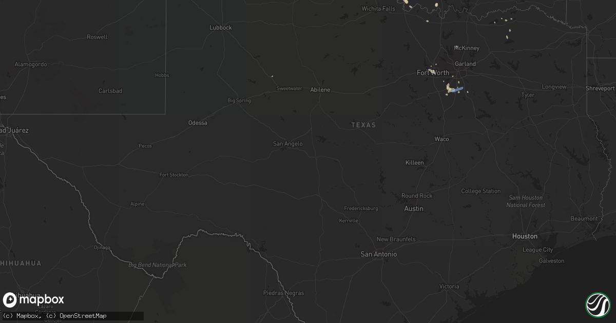
Hail Map in Texas on July 2, 2020
Get this storm
July 2 map
$229
one time, instant access
Download today. No call, no setup
Keep the $229
Bought the map and want the full workflow? Apply the entire $229 to a subscription within 7 days. None of it is wasted.
Every map, not just this one
This buys you this map. Subscription and you get every map we run, in the markets you choose from a few cities to whole states to nationwide. Plus real-time alerts the moment a storm fires.
Contact data
Name, contact info, occupancy, even credit band for addresses in the footprint. You go from where it hit to who to call.
Become the source they trust
Unlimited branding weather history reports on demand. You already have the documented answer ready for the property owner, and you are the one who showed up with it.
Property data and RoofTrace estimates
Pull up any address you have got, its value and the exact code rules for that jurisdiction, straight from One Click Code. Then RoofTrace estimates the squares, pitch, and roof value, priced the way you price.
Storm reports in Texas
Texas
| Date | Description |
|---|---|
| 07/02/20206:55 PM CDT | A local report indicates 60 MPH wind near 3 NNE MIDLAND |
| 07/02/20206:55 PM CDT | A local report indicates 60 MPH wind near 3 NNW MIDLAND |
| 07/02/20206:19 PM CDT | Report from mping: 1-inch tree limbs broken; shingles blown off. |
| 07/02/20206:10 PM CDT | Reports of downed power poles at saginaw blvd and boaz. |
| 07/02/20202:05 AM CDT | At 704 PM CDT, a severe thunderstorm was located 4 miles east of Ryan, moving northwest at 5 mph. HAZARD...70 mph wind gusts and quarter size hail. SOURCE...Radar indicated. IMPACT...Hail damage to vehicles is expected. Expect considerable tree damage. Wind damage is also likely to mobile homes, roofs, and outbuildings. Locations impacted include... Waurika, Ryan, Terral, Hastings and Sugden. |
| 07/02/20201:54 AM CDT | At 654 PM CDT, a severe thunderstorm was located near Midland, and is nearly stationary. HAZARD...60 mph wind gusts and penny size hail. SOURCE...Radar indicated. IMPACT...Expect damage to roofs, siding, and trees. Locations impacted include... Midland and Midland Airpark. This includes Interstate 20 between mile markers 140 and 145. |
| 07/02/20201:36 AM CDT | At 635 PM CDT, a severe thunderstorm was located over Palmer, or near Ennis, moving east at 35 mph. HAZARD...60 mph wind gusts and quarter size hail. SOURCE...Radar indicated. IMPACT...Hail damage to vehicles is expected. Expect wind damage to roofs, siding, and trees. Locations impacted include... Lancaster, Ennis, Glenn Heights, Red Oak, Ferris, Palmer, Bardwell, Alma, Garrett and Pecan Hill.This includes the following highways... Interstate 35E between mile markers 410 and 411. Interstate 45 between mile markers 244 and 266. |
| 07/02/20201:14 AM CDT | At 613 PM CDT, a severe thunderstorm was located 3 miles northwest of Marietta, moving southeast at 15 mph. HAZARD...60 mph wind gusts and quarter size hail. SOURCE...Radar indicated. IMPACT...Hail damage to vehicles is expected. Expect wind damage to roofs, siding, and trees. Locations impacted include... Marietta, Thackerville and Burneyville. |
| 07/02/20201:11 AM CDT | At 611 PM CDT, a severe thunderstorm was located near Maypearl, or near Waxahachie, and is nearly stationary. HAZARD...60 mph wind gusts and penny size hail. SOURCE...Radar indicated. IMPACT...Expect damage to roofs, siding, and trees. Locations impacted include... Grand Prairie, Mansfield, Cedar Hill, Waxahachie, Ennis, Midlothian, Glenn Heights, Red Oak, Ovilla, Venus, Palmer, Italy, Oak Leaf, Maypearl, Bardwell, Garrett and Pecan Hill.This includes the following highways... Interstate 35E between mile markers 384 and 411. Interstate 45 between mile markers 249 and 257. |
| 07/02/20201:02 AM CDT | At 601 PM CDT, a severe thunderstorm was located near Downtown Fort Worth and River oaks. Movement was nearly stationary. HAZARD...60 mph wind gusts and quarter size hail. SOURCE...Radar indicated. IMPACT...Hail damage to vehicles is expected. Expect wind damage to roofs, siding, and trees. Locations impacted include... Fort Worth, Arlington, Grand Prairie, Mansfield, Euless, Bedford, Haltom City, Hurst, Watauga, Benbrook, Saginaw, White Settlement, Forest Hill, Richland Hills, River Oaks, Kennedale, Everman, Sansom Park, Lake Worth and Eagle Mountain.This includes the following highways... Interstate 35W between mile markers 41 and 61. Interstate 20 between mile markers 430 and 453. Interstate 30 between mile markers 4 and 32. |
| 07/01/202011:50 PM CDT | At 449 PM CDT, a severe thunderstorm was located over Duncanville, moving southwest at 10 mph. At 440 PM CDT, 62 mph winds were observed at the Dallas Redbird Airport. HAZARD...60 mph wind gusts and small hail. SOURCE...Radar indicated. IMPACT...Expect damage to roofs, siding, and trees. Locations impacted include... Dallas, Arlington, Irving, Grand Prairie, Mansfield, Desoto, Cedar Hill, Duncanville, Lancaster, Glenn Heights, Cockrell Hill, Ovilla and Cedar Hill State Park.This includes the following highways... Interstate 35E between mile markers 416 and 422. Interstate 20 between mile markers 449 and 467. Interstate 30 between mile markers 35 and 39. |
All States Impacted by Hail Map on July 2, 2020
Cities Impacted by Hail Map on July 2, 2020
- Monett, MO
- Burlington, CO
- Valentine, NE
- Alpena, AR
- Little Rock, AR
- Coldwater, MS
- Medway, ME
- Hays, KS
- Lake Village, AR
- Presho, SD
- Vivian, SD
- Scott City, KS
- Arapahoe, CO
- Sheridan Lake, CO
- Richardton, ND
- Mud Butte, SD
- Faith, SD
- Wray, CO
- Wilmar, AR
- Lansford, ND
- Glenburn, ND
- Stark, KS
- Savonburg, KS
- Dover, AR
- Rocklake, ND
- Rolla, ND
- Hansboro, ND
- Dunn Center, ND
- Taylor, ND
- Halliday, ND
- Rapid City, SD
- St John, KS
- Dodd City, TX
- Windom, TX
- Bayard, NE
- Panhandle, TX
- Gurley, NE
- Peetz, CO
- Sidney, NE
- Deer, AR
- Parshall, ND
- Roseglen, ND
- Belleville, KS
- Scandia, KS
- Concordia, KS
- Jamestown, KS
- Kilgore, NE
- Nenzel, NE
- Oakley, KS
- Hanston, KS
- Kinsley, KS
- Saint James, MO
- Chandler, OK
- Perryville, AR
- Fort Worth, TX
- Gregory, SD
- Bethune, CO
- Carl Junction, MO
- Joplin, MO
- Webb City, MO
- Monticello, AR
- Grady, AR
- Fairfax, OK
- Pierce City, MO
- Hill City, SD
- Keystone, SD
- Goodland, KS
- Clarksville, AR
- Lamar, AR
- Prairie City, SD
- Cope, CO
- Anton, CO
- Buena Vista, GA
- Union Center, SD
- Newell, SD
- Bird City, KS
- Saint Francis, KS
- Benkelman, NE
- Gladstone, ND
- Hemingford, NE
- Lamar, CO
- Wiley, CO
- Hasty, CO
- McClave, CO
- Harvey, ND
- Chaseley, ND
- Bowdon, ND
- Burr Oak, KS
- Tupelo, OK
- De Witt, AR
- Greenville, MS
- Leland, MS
- Bentonia, MS
- Newcastle, WY
- Hermosa, SD
- Oberon, ND
- Springdale, AR
- Oral, SD
- Pine Ridge, SD
- Champion, NE
- Carpio, ND
- Salina, KS
- Alexander, AR
- Mabelvale, AR
- Bauxite, AR
- Howes, SD
- Pierre, SD
- Blunt, SD
- Guide Rock, NE
- Searcy, AR
- Hugo, OK
- Rison, AR
- Lake Wales, FL
- Atwood, KS
- Selden, KS
- Hoxie, KS
- Rexford, KS
- Lexington, MS
- Cruger, MS
- Sturgis, SD
- Mulberry, AR
- Ryan, OK
- Crawford, NE
- Dumas, AR
- Healy, KS
- Grinnell, KS
- Ogallala, NE
- Paxton, NE
- Keystone, NE
- Harrison, AR
- Rolette, ND
- Rugby, ND
- White Owl, SD
- Whitman, NE
- Max, NE
- Lincoln, KS
- Sylvan Grove, KS
- Drumright, OK
- Dresden, KS
- Yale, OK
- Regent, ND
- Hettinger, ND
- Colby, KS
- Garden City, KS
- Leslie, AR
- Dickinson, ND
- New England, ND
- Amidon, ND
- Midland, SD
- Draper, SD
- Fort Pierre, SD
- Okaton, SD
- Murdo, SD
- Hayes, SD
- Satanta, KS
- Berthold, ND
- Lindsborg, KS
- Assaria, KS
- Reva, SD
- Edson, KS
- Utica, KS
- Hominy, OK
- Vale, SD
- Madison, ME
- Sarah, MS
- Crenshaw, MS
- Indianola, MS
- Hollandale, MS
- Inverness, MS
- Stratton, CO
- Cody, NE
- Tuthill, SD
- Saint Francis, SD
- Aladdin, WY
- Marsland, NE
- Rogers, AR
- Yazoo City, MS
- Glenpool, OK
- Phillips, WI
- Lebanon, NE
- Shaw, MS
- Doddsville, MS
- Kensal, ND
- Booneville, AR
- Ponca, AR
- Garfield, KS
- Belpre, KS
- Larned, KS
- Guymon, OK
- Chamberlain, SD
- England, AR
- Pine Bluff, AR
- Cherry Creek, SD
- Philip, SD
- Milesville, SD
- Miller, SD
- Lakin, KS
- Belzoni, MS
- Crookston, NE
- Shell Knob, MO
- Washburn, ND
- Hayes Center, NE
- Mountain View, AR
- Magazine, AR
- Thedford, NE
- Pawhuska, OK
- Shidler, OK
- Burbank, OK
- Granada, CO
- Berryville, AR
- Hudson, KS
- Maple City, KS
- Dexter, KS
- Herndon, KS
- Hernando, MS
- Lyon, MS
- Clarksdale, MS
- Silver City, MS
- Hudson, ME
- Spencer, NE
- Oneill, NE
- Waxahachie, TX
- Cedar Hill, TX
- Midlothian, TX
- McIntosh, SD
- McLaughlin, SD
- Kanorado, KS
- Victoria, KS
- Walker, KS
- Gorham, KS
- Wood, SD
- Tulsa, OK
- Sapulpa, OK
- Sand Springs, OK
- Belleville, AR
- Danville, AR
- Plaza, ND
- Ryder, ND
- Killdeer, ND
- Green Forest, AR
- Abilene, KS
- Solomon, KS
- Minter City, MS
- Charleston, MS
- Akron, CO
- Bolton, MS
- Wasta, SD
- Enning, SD
- Winner, SD
- Hamill, SD
- Wauneta, NE
- Stratton, NE
- Oxford, MS
- Water Valley, MS
- Tutwiler, MS
- Imperial, NE
- Enders, NE
- Superior, NE
- Dundee, MS
- Sledge, MS
- Isola, MS
- Mankato, KS
- Yellville, AR
- Caputa, SD
- Holdenville, OK
- Wetumka, OK
- Parthenon, AR
- Woodworth, ND
- Sheridan, AR
- Warren, AR
- Elkhart, KS
- Jenks, OK
- Pittsboro, MS
- Tillar, AR
- Perth, ND
- Vernon, CO
- Weskan, KS
- Parks, NE
- Sterling, CO
- Kress, TX
- Red Oak, TX
- Otis, KS
- Pfeifer, KS
- Russell, KS
- Jetmore, KS
- Ellis, KS
- Scenic, SD
- New Salem, ND
- Dighton, KS
- Milburn, OK
- Kenefic, OK
- Brewster, KS
- Eagle Butte, SD
- Dupree, SD
- Lantry, SD
- Gove, KS
- Aurora, MO
- Reeds Spring, MO
- Brinkley, AR
- Hamburg, AR
- Pittsburg, KS
- Asbury, MO
- Coleharbor, ND
- Milo, ME
- Seligman, MO
- Garfield, AR
- Eagle Rock, MO
- Keller, TX
- Elkins, AR
- Fayetteville, AR
- Weleetka, OK
- Bassett, NE
- Bridgeport, NE
- Angora, NE
- Batesville, AR
- Portales, NM
- Wessington Springs, SD
- Gypsum, KS
- Cape Fair, MO
- Beeler, KS
- Sterling, KS
- Omaha, AR
- Mounds, OK
- Pritchett, CO
- Okemah, OK
- Seminole, OK
- Sarcoxie, MO
- Selfridge, ND
- Mayersville, MS
- Carrington, ND
- Brownell, KS
- McCracken, KS
- Burdett, KS
- Cherokee, KS
- Weir, KS
- Cushing, OK
- Poteau, OK
- Meadow, SD
- Joes, CO
- Vona, CO
- Kirk, CO
- Senatobia, MS
- Coahoma, MS
- Gordon, NE
- Columbus, KS
- Hollister, MO
- Bisbee, ND
- Knox, ND
- Hugoton, KS
- Moscow, KS
- Glencoe, OK
- Sarles, ND
- Lefor, ND
- Kinta, OK
- Park, KS
- Quinter, KS
- Wisner, LA
- Morland, KS
- Denhoff, ND
- Goodrich, ND
- Merigold, MS
- Ruleville, MS
- Cleveland, MS
- Ferriday, LA
- Dardanelle, AR
- Sahuarita, AZ
- Hazen, ND
- Stanton, ND
- Culbertson, NE
- Carthage, MO
- Reeds, MO
- Bixby, OK
- Stuart, NE
- Lenora, KS
- Stillwater, OK
- Mccurtain, OK
- Great Bend, KS
- Jefferson, AR
- Penokee, KS
- Hill City, KS
- Huntsville, AR
- Harmony, ME
- Hunter, KS
- Belcourt, ND
- Curtis, NE
- Snow Lake, AR
- Watson, AR
- Merriman, NE
- Lodgepole, SD
- Hagarville, AR
- Altus, AR
- Ozark, AR
- Hartman, AR
- Houlton, ME
- Cassville, MO
- Carson, ND
- Uniontown, KS
- Golden, MO
- Bisbee, AZ
- Tombstone, AZ
- Thorndike, ME
- Troy, ME
- Harrison, NE
- Oark, AR
- Redfield, AR
- Madrid, NE
- Galena, MO
- Potter, NE
- Portis, KS
- Oronogo, MO
- Paris, AR
- Claude, TX
- Troy, NY
- Dalton, NE
- Eustis, NE
- Lowell, AR
- Stafford, KS
- Lewis, KS
- Macksville, KS
- Branson, MO
- Okmulgee, OK
- Gann Valley, SD
- Downs, KS
- Long Pine, NE
- Dustin, OK
- Belvidere, SD
- Winona, KS
- Monument, KS
- Marienthal, KS
- Holly, CO
- Ruso, ND
- Benedict, ND
- Grant, NE
- Bingham, ME
- Ralston, OK
- Buffalo, SD
- Duncan, MS
- Anderson, MO
- Pineville, MO
- Bristow, OK
- Valley Springs, AR
- Lampe, MO
- Anson, ME
- Newton, KS
- Mylo, ND
- Fairfield, ME
- Gainesville, MO
- Wing, ND
- Galena, KS
- Ponca City, OK
- Martin, SD
- Stuart, FL
- Indiantown, FL
- Osborne, KS
- Cuba, MO
- Pawnee, OK
- Benton, AR
- Ellinwood, KS
- Portland, AR
- Waterford, NY
- Mechanicville, NY
- Beloit, KS
- Tribune, KS
- Elgin, ND
- Ulysses, KS
- Sublette, KS
- Kingsland, AR
- Bearden, AR
- Sherman, ME
- Eureka Springs, AR
- Plainview, AR
- Humphrey, AR
- Louise, MS
- Anguilla, MS
- Wall, SD
- Marietta, OK
- Waterville, ME
- Chapman, KS
- Saint Bernard, LA
- Helena, AR
- Drew, MS
- Scranton, AR
- Turtle Lake, ND
- Ripley, OK
- Beggs, OK
- Pea Ridge, AR
- Oviedo, FL
- Orlando, FL
- Minneapolis, KS
- Grapevine, AR
- Island Falls, ME
- Wasola, MO
- Glen Allan, MS
- Chatham, MS
- McCook, NE
- Maywood, NE
- Mansfield, TX
- Girard, KS
- Maypearl, TX
- Venus, TX
- Napoleon, ND
- Lamar, OK
- Barnard, KS
- Jasper, AR
- Perkins, OK
- Coalgate, OK
- Athens, ME
- Sundance, WY
- Marble Falls, AR
- Marks, MS
- Shelby, MS
- Mound Bayou, MS
- Hindsville, AR
- Tryon, OK
- Brookston, TX
- Moundridge, KS
- Ransom, KS
- Miami, OK
- Kingston, AR
- Roxton, TX
- Milford, KS
- Bradford, AR
- Saint Lawrence, SD
- Johnson, KS
- Chadwick, MO
- Almont, ND
- Hurdsfield, ND
- Makoti, ND
- Plainville, KS
- Langdon, ND
- Barnsdall, OK
- White Hall, AR
- Ivan, AR
- Pingree, ND
- Pleasant Grove, AR
- Ennis, TX
- Hensley, AR
- Prosper, TX
- Oberlin, KS
- Red Rock, OK
- Como, MS
- North Anson, ME
- Chestnutridge, MO
- Walnut Shade, MO
- Hanna, OK
- Brookville, KS
- New Underwood, SD
- Newport, AR
- Verona, MO
- Purdy, MO
- Esbon, KS
- Augusta, AR
- Fort Lauderdale, FL
- Fordyce, AR
- Gould, AR
- Sicily Island, LA
- Flippin, AR
- Compton, AR
- Waldron, AR
- Wapanucka, OK
- Pickens, AR
- Bartley, NE
- Indianola, NE
- Hermleigh, TX
- Holyrood, KS
- Claflin, KS
- Freistatt, MO
- Gunnison, MS
- Fairfax, SD
- Butte, NE
- Washburn, MO
- Banks, AR
- Whitney, NE
- Clinton, AR
- Cooper, TX
- Gentry, AR
- Cave City, AR
- Trenton, NE
- Regan, ND
- Red Oak, OK
- Ethel, AR
- Canton, MS
- Heavener, OK
- Howe, OK
- Lancaster, TX
- Noel, MO
- Tolley, ND
- Gravette, AR
- Tucker, AR
- Black Hawk, SD
- Mercer, ND
- Natoma, KS
- Bogalusa, LA
- Woodbine, KS
- Burden, KS
- Winfield, KS
- Tipton, KS
- Pomona, MO
- Wesley, AR
- Sherrill, AR
- Sumner, TX
- Piedmont, SD
- Reliance, SD
- Broken Arrow, OK
- Coal Hill, AR
- Ellsworth, KS
- Dallas, TX
- Duncanville, TX
- Deadwood, SD
- Muenster, TX
- Solon, ME
- Allen, OK
- Protem, MO
- Silverton, TX
- Oacoma, SD
- New Edinburg, AR
- Gassville, AR
- Mission, SD
- Moro, AR
- Sylvia, KS
- Kanopolis, KS
- Erie, KS
- Agra, OK
- Benedicta, ME
- Kiefer, OK
- Abbyville, KS
- Plevna, KS
- Mount Vernon, AR
- Lebanon, KS
- Subiaco, AR
- Keldron, SD
- Holly Grove, AR
- Muleshoe, TX
- Havana, AR
- New Blaine, AR
- Oak Grove, LA
- Arlington, KS
- Turon, KS
- Magee, MS
- Mount Olive, MS
- Palmer, TX
- Ferris, TX
- New Braintree, MA
- Barre, MA
- Oakham, MA
- Jennings, KS
- Gem, KS
- Logan, KS
- Norcatur, KS
- Clayton, KS
- Levant, KS
- Norton, KS
- Long Island, KS
- Prairie View, KS
- Almena, KS
- Delphos, KS
- Glasco, KS
- Halstead, KS
- Sedgwick, KS
- Haysville, KS
- Belle Plaine, KS
- Mulvane, KS
- Derby, KS
- Peck, KS
- Dodge, ND
- Max, ND
- Minot Afb, ND
- Westhope, ND
- Burlington, ND
- Maxbass, ND
- Minot, ND
- Lincoln, MA
- Waltham, MA
- Weston, MA
- Custer, SD


