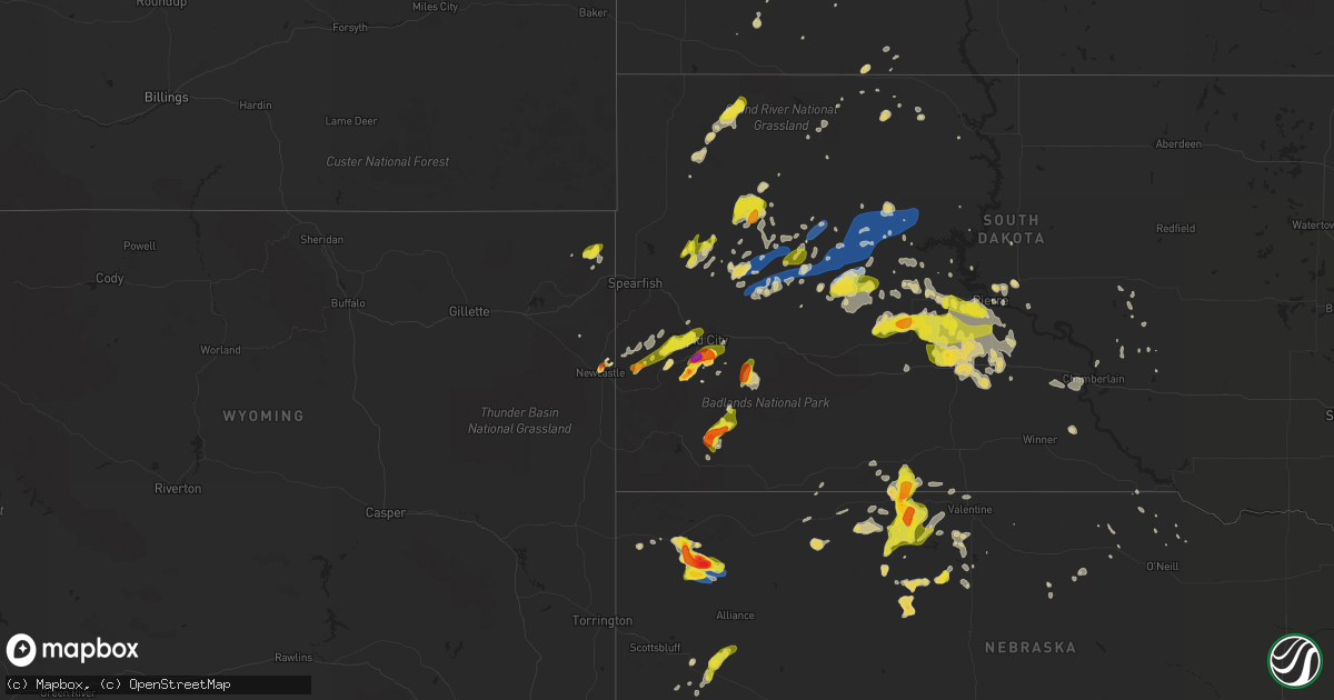
Hail Map on July 2, 2020
Get this storm
July 2 map
$229
one time, instant access
Download today. No call, no setup
Keep the $229
Bought the map and want the full workflow? Apply the entire $229 to a subscription within 7 days. None of it is wasted.
Every map, not just this one
This buys you this map. Subscription and you get every map we run, in the markets you choose from a few cities to whole states to nationwide. Plus real-time alerts the moment a storm fires.
Contact data
Name, contact info, occupancy, even credit band for addresses in the footprint. You go from where it hit to who to call.
Become the source they trust
Unlimited branding weather history reports on demand. You already have the documented answer ready for the property owner, and you are the one who showed up with it.
Property data and RoofTrace estimates
Pull up any address you have got, its value and the exact code rules for that jurisdiction, straight from One Click Code. Then RoofTrace estimates the squares, pitch, and roof value, priced the way you price.
States Impacted by Hail Map on July 2, 2020
Storm reports
Missouri
| Date | Description |
|---|---|
| 07/02/20206:11 PM CDT | Tree debris blocking joe bald park rd. |
| 07/02/20205:43 PM CDT | Several 3 to 5 inch trees blown down just south of anderson on old highway 71. |
| 07/02/20205:05 PM CDT | Tree over the road at county lane 90 and blackberry road. |
| 07/02/20204:45 PM CDT | 4 inch tree blown down just east of northpark mall. |
| 07/02/20204:40 PM CDT | Initial report of approx 15 power poles down. Near belview on newman rod... Near northpark apartments. Several cars involved with the power lines also. |
| 07/02/202012:36 AM CDT | At 535 PM CDT, a severe thunderstorm was located near Pineville, moving southeast at 15 mph. HAZARD...60 mph wind gusts and quarter size hail. SOURCE...Radar indicated. IMPACT...Hail damage to vehicles is expected. Expect wind damage to roofs, siding, and trees. Locations impacted include... Big Sugar Creek State Park... Anderson... Seligman... Pineville... Washburn... Lanagan... Powell... This includes Interstate 49 between mile markers 1 and 12. |
| 07/01/202011:59 PM CDT | At 459 PM CDT, severe thunderstorms were located along a line extending from 8 miles east of Sarcoxie to near Shoal Creek Drive to near Baxter Springs, moving south at 20 mph. HAZARD...60 mph wind gusts and quarter size hail. SOURCE...Radar indicated. IMPACT...Hail damage to vehicles is expected. Expect wind damage to roofs, siding, and trees. Locations impacted include... Joplin... Carthage... Neosho... Webb City... Monett... Carl Junction... Baxter Springs... Galena... Oronogo... Seneca... Granby... Carterville... Duquesne... Sarcoxie... Pierce City... Duenweg... Diamond... Loma Linda... Airport Drive... Leawood...This includes the following highways... Interstate 44 between mile markers 0 and 41. Interstate 49 between mile markers 16 and 45. |
Massachusetts
| Date | Description |
|---|---|
| 07/02/20205:10 PM CDT | Tree down on wires on school street |
| 07/02/20205:10 PM CDT | Trees down on wires on lincoln road |
| 07/02/20205:05 PM CDT | Large tree down on power lines on hillsville road |
| 07/02/20205:04 PM CDT | Tree down on rte 148 near brooks pond road |
| 07/02/20205:02 PM CDT | A large tree was snapped |
| 07/02/20204:44 PM CDT | Tree down on power lines on worcester road |
| 07/02/20203:22 AM CDT | At 821 PM EDT, a severe thunderstorm was located over Bedford, or near Lexington, moving south at 25 mph. HAZARD...60 mph wind gusts. SOURCE...Radar indicated. IMPACT...Expect damage to trees and power lines. Locations impacted include... Boston, Cambridge, Quincy, Newton, Somerville, Framingham, Waltham, Brookline, Medford, Arlington, Billerica, Woburn, Braintree, Chelmsford, Natick, Randolph, Watertown, Lexington, Tewksbury and Needham. |
| 07/02/202012:48 AM CDT | At 548 PM EDT, a severe thunderstorm was located near Nassau, moving south at 35 mph. HAZARD...60 mph wind gusts. SOURCE...Radar indicated. IMPACT...Expect damage to roofs, siding, and trees. Locations impacted include... Pittsfield, Great Barrington, Hudson, Chatham, Nassau, Claverack, Lee, Lenox, New Baltimore, Ravena, Stephentown, Coxsackie, New Lebanon, Valatie, Austerlitz, Castleton-On-Hudson, Philmont, Kinderhook, Lorenz Park and Selkirk. |
| 07/02/202012:35 AM CDT | At 535 PM EDT, a severe thunderstorm was located near Barre, or 16 miles southeast of Orange, moving south at 20 mph. HAZARD...60 mph wind gusts and quarter size hail. SOURCE...Radar indicated. IMPACT...Expect wind damage to trees and power lines. Minor hail damage to vehicles is possible. Locations impacted include... Southbridge, Oxford, Charlton, Palmer, Spencer, Dudley, Leicester, Ware, Sturbridge, Rutland, Barre, Warren, Paxton, North Brookfield, Hubbardston, West Brookfield, Brimfield, Brookfield, Hardwick and Holland. |
| 07/01/20208:20 PM CDT | Tree down across cleveland street |
| 07/01/20208:11 PM CDT | Tree down blocking half of the westbound lane of high street at dover rd in westwood. |
| 07/01/20208:00 PM CDT | Trees down into house on aberdeen road. Tree down into house on bobolink road |
| 07/01/20207:50 PM CDT | Tree down on car on columbus place... Tree down on house on larch street |
| 07/01/20207:47 PM CDT | Tree down blocking route 20 |
| 07/01/20207:40 PM CDT | Large tree down and wires down on bedford street |
| 07/01/20207:31 PM CDT | Multipile trees down on proctor road |
| 07/01/20207:31 PM CDT | Tree down on house on harper street |
| 07/01/20207:30 PM CDT | Multiple trees down on curve street |
Rhode Island
| Date | Description |
|---|---|
| 07/02/20204:53 AM CDT | At 953 PM EDT, a severe thunderstorm was located near Scituate, or near Coventry, moving south at 25 mph. HAZARD...60 mph wind gusts. SOURCE...Radar indicated. IMPACT...Expect damage to trees and power lines. Locations impacted include... Warwick, Cranston, Coventry, South Kingstown, West Warwick, Johnston, North Kingstown, Newport, Smithfield, Narragansett, East Greenwich, Scituate, Charlestown, Richmond, Exeter, West Greenwich, Jamestown and Foster. |
| 07/02/20204:09 AM CDT | At 907 PM EDT, a severe thunderstorm was located over Walpole, or near Norwood, moving south at 30 mph. HAZARD...60 mph wind gusts. SOURCE...Radar indicated. This storm has a history of downing multiple trees and powerlines as it moved through Bedford and Waltham. IMPACT...Expect damage to trees and power lines. Locations impacted include... Boston, Brockton, Pawtucket, Taunton, East Providence, Randolph, Franklin, North Attleborough, Norwood, Milton, Stoughton, Attleboro, Dedham, Walpole, Mansfield, Easton, Canton, Norton, Somerset and Sharon. |
| 07/01/20209:12 PM CDT | Two vehicles were crushed by fallen trees on hill farm camp rd in coventry. |
| 07/01/20209:10 PM CDT | Tree down blocking hill farm road |
Louisiana
| Date | Description |
|---|---|
| 07/02/20204:00 PM CDT | Tree downed by thunderstorm winds at the intersection of la hwy 434 and todd road. |
| 07/02/202012:18 AM CDT | At 518 PM CDT, a severe thunderstorm was located 7 miles west of Oak Grove, or 12 miles south of Wilmot, moving southeast at 5 mph. HAZARD...60 mph wind gusts and nickel size hail. SOURCE...Radar indicated. IMPACT...Expect damage to roofs, siding, and trees. Locations impacted include... Oak Grove, Goodwill, Forest and Pioneer. |
| 07/01/202011:41 PM CDT | At 441 PM CDT, severe thunderstorms were located along a line extending from 14 miles north of Metairie to near New Orleans, moving south at 15 mph. HAZARD...60 mph wind gusts. SOURCE...Radar indicated. IMPACT...Expect damage to roofs, siding, and trees. Locations impacted include... New Orleans, Metairie, East New Orleans, Hahnville, Laplace, Norco, New Sarpy, Taft, Montz, Destrehan, New Orleans Armstrong Airport and Lakefront Airport. |
Mississippi
| Date | Description |
|---|---|
| 07/02/20201:05 PM CDT | A tree fell on a house along first street. |
| 07/01/202010:42 PM CDT | At 342 PM CDT, a severe thunderstorm was located near Tribbett, or near Indianola, moving south at 20 mph. HAZARD...60 mph wind gusts and nickel size hail. SOURCE...Radar indicated. IMPACT...Expect damage to roofs, siding, and trees. This severe thunderstorm will be near... Tribbett around 350 PM CDT. Darlove around 410 PM CDT. Estill around 420 PM CDT. Hollandale around 425 PM CDT. Murphy around 430 PM CDT.Other locations impacted by this severe thunderstorm include Arcola. |
| 07/01/202010:08 PM CDT | At 307 PM CDT, a severe thunderstorm was located near Sunflower, or 7 miles north of Indianola, moving south at 20 mph. HAZARD...60 mph wind gusts and penny size hail. SOURCE...Radar indicated. IMPACT...Expect damage to roofs, siding, and trees. This severe thunderstorm will be near... Indianola around 330 PM CDT. Holly Ridge around 340 PM CDT. Inverness around 345 PM CDT. |
| 07/01/20209:30 PM CDT | At 230 PM CDT, a severe thunderstorm was located 8 miles southwest of Thornton, moving south at 15 mph. HAZARD...60 mph wind gusts and nickel size hail. SOURCE...Radar indicated. IMPACT...Expect damage to roofs, siding, and trees. This severe thunderstorm will be near... Yazoo City around 310 PM CDT.Other locations impacted by this severe thunderstorm include Eden. |
| 07/01/20209:19 PM CDT | At 219 PM CDT, a severe thunderstorm was located near Tchula, or 10 miles southwest of Black Hawk, and is nearly stationary. HAZARD...60 mph wind gusts and nickel size hail. SOURCE...Radar indicated. IMPACT...Expect damage to roofs, siding, and trees. Locations impacted include... Tchula, Lexington, Emory, Brozville and Howard. |
Arkansas
| Date | Description |
|---|---|
| 07/02/20203:19 AM CDT | At 819 PM CDT, a severe thunderstorm was located over Mound Bayou, or near Shelby, moving south at 30 mph. HAZARD...60 mph wind gusts and penny size hail. SOURCE...Radar indicated. IMPACT...Expect damage to roofs, siding, and trees. This severe thunderstorm will be near... Renova around 835 PM CDT. Cleveland and Boyle around 845 PM CDT. Shaw around 900 PM CDT.Other locations impacted by this severe thunderstorm includeWinstonville, Beulah, Pace and Merigold. |
| 07/02/20201:33 AM CDT | At 633 PM CDT, a severe thunderstorm was located 7 miles east of Plantersville, or 11 miles north of Monticello, moving southwest at 10 mph. HAZARD...60 mph wind gusts and quarter size hail. SOURCE...Radar indicated. IMPACT...Hail damage to vehicles is expected. Expect wind damage to roofs, siding, and trees. Locations impacted include... Monticello... Plantersville... Brandon... Montongo... Rock Springs... Coleman... Relfs Bluff... |
| 07/02/202012:32 AM CDT | At 532 PM CDT, a severe thunderstorm was located 12 miles west of Kimberling City, moving south at 5 mph. HAZARD...60 mph wind gusts and quarter size hail. SOURCE...Radar indicated. IMPACT...Hail damage to vehicles is expected. Expect wind damage to roofs, siding, and trees. Locations impacted include... Table Rock Lake... Roaring River State Park... Shell Knob... Golden... Emerald Beach... Eagle Rock... Chain-O-Lakes... Arrow Point... |
| 07/02/202012:09 AM CDT | At 509 PM CDT, severe thunderstorms were located along a line extending from near Greenville to near Chicot Junction, moving southeast at 5 mph. HAZARD...60 mph wind gusts and quarter size hail. SOURCE...Radar indicated. IMPACT...Hail damage to vehicles is expected. Expect wind damage to roofs, siding, and trees. Severe thunderstorms will be near... Chicot Junction around 540 PM CDT. Eudora, Avon and Wayside around 600 PM CDT.Other locations impacted by these severe thunderstorms includeArcola. |
| 07/01/202011:19 PM CDT | At 418 PM CDT, a severe thunderstorm was located near Glen Allan, or 11 miles south of Avon, and is nearly stationary. HAZARD...60 mph wind gusts and nickel size hail. SOURCE...Radar indicated. IMPACT...Expect damage to roofs, siding, and trees. Locations impacted include... Shelburn, Gassoway, Millikin, Grace, Glen Allan and Mayersville. |
| 07/01/20209:55 PM CDT | At 255 PM CDT, a severe thunderstorm was located over Fairfield Bay Marina, or near Fairfield Bay, moving south at 20 mph. HAZARD...60 mph wind gusts and quarter size hail. SOURCE...Radar indicated. IMPACT...Hail damage to vehicles is expected. Expect wind damage to roofs, siding, and trees. Locations impacted include... Fairfield Bay... Quitman... Guy... Fairbanks... Fairfield Bay Marina... Sugar Loaf Recreation Area... South Fork Recreation Area... Morganton... Pearson... Choctow Recreation Area... |
| 07/01/20209:44 PM CDT | At 243 PM CDT, a severe thunderstorm was located over Claude, or 10 miles southwest of Clinton, moving southeast at 5 mph. HAZARD...60 mph wind gusts and quarter size hail. SOURCE...Radar indicated. IMPACT...Hail damage to vehicles is expected. Expect wind damage to roofs, siding, and trees. Locations impacted include... Whipple... Catholic Point... Middleton... Claude... Birdtown... Bee Branch... Beverage Town... Austin in Conway County... Southside in Van Buren County... Center Ridge... Formosa... |
Idaho
| Date | Description |
|---|---|
| 07/02/20201:55 AM CDT | At least 2 trees down... One falling on a building... At idaho falls country club. Time of damage estimated based on radar and information from social media. |
Michigan
| Date | Description |
|---|---|
| 07/01/20209:39 PM CDT | At 239 PM CDT, a severe thunderstorm was located near Powers, or 23 miles southwest of Escanaba, moving south at 15 mph. HAZARD...60 mph wind gusts and nickel size hail. SOURCE...Radar indicated. IMPACT...Expect damage to roofs, siding, and trees. Locations impacted include... Stephenson, Powers, Bagley, Nadeau, Gourley, Daggett and Carney. |
South Dakota
| Date | Description |
|---|---|
| 07/02/20206:13 PM CDT | Lots of tree limbs down |
| 07/02/20205:53 PM CDT | Lots of tree limbs down |
| 07/02/20205:48 PM CDT | A local report indicates 1.00 inch wind near 1 SW MARCUS |
| 07/02/20205:33 PM CDT | Estimated at least 60 mph wind gusts |
| 07/02/20205:30 PM CDT | Photo shows several large hail stones up to golf ball sized |
| 07/02/20205:20 PM CDT | Time estimated from radar. Had been melting for at least half an hour. |
| 07/02/20205:14 PM CDT | A local report indicates 60 MPH wind near ENNING |
| 07/02/20205:12 PM CDT | Also a 49 mph wind gust before hail broke anemometer. |
| 07/02/20205:10 PM CDT | Pea to quarter sized hail covered the ground. Time of onset of large hail estimated from radar. |
| 07/02/20205:10 PM CDT | Photo shows hail measured at least 2 inches in diameter. |
| 07/02/20205:09 PM CDT | A local report indicates 73 MPH wind near 3 W UNION CENTER |
| 07/02/20205:00 PM CDT | Photo shows several measured hail stones approximately two inches in diameter |
| 07/02/20204:34 PM CDT | A local report indicates 59 MPH wind near 7 NNE RALPH |
| 07/02/20204:34 PM CDT | Started at this time and fell for about five minutes. |
| 07/02/20204:30 PM CDT | Photo shows hail of at least half dollar sized. Time estimated from radar. |
| 07/02/20204:30 PM CDT | Image compared to a quarter shows hail about half dollar sized. Start time estimated from radar. |
| 07/02/20204:29 PM CDT | A local report indicates 59 MPH wind near 7 NNE RALPH |
| 07/02/20204:20 PM CDT | Picture of hail showed some stones of at least half dollar size |
| 07/02/20204:10 PM CDT | A local report indicates 1.00 inch wind near 2 S PACTOLA RESV |
| 07/02/20204:09 PM CDT | Lots of 3/4 to inch hail |
| 07/02/20204:06 PM CDT | Most were pea to dime size but a few larger |
| 07/02/20204:00 PM CDT | Time of largest hail estimated from radar. |
| 07/02/20203:38 PM CDT | A local report indicates 60 MPH wind near 1 ENE MUD BUTTE |
| 07/02/20203:20 PM CDT | Delayed report. Time estimated from radar. |
| 07/02/20202:56 PM CDT | A local report indicates 1.00 inch wind near 3 SE NEWELL |
| 07/02/20205:55 AM CDT | At 1055 PM CDT, a severe thunderstorm was located near Miller, moving east at 35 mph. HAZARD...60 mph wind gusts and quarter size hail. SOURCE...Radar indicated. IMPACT...Hail damage to vehicles is expected. Expect wind damage to roofs, siding, and trees. This severe thunderstorm will be near... St. Lawrence around 1105 PM CDT. Vayland around 1115 PM CDT. |
| 07/02/20204:29 AM CDT | At 929 PM CDT/829 PM MDT/, severe thunderstorms were located along a line extending from 14 miles south of Fort Pierre to 6 miles south of Okaton, moving southeast at 60 mph. HAZARD...60 mph wind gusts and quarter size hail. SOURCE...Radar indicated. IMPACT...Hail damage to vehicles is expected. Expect wind damage to roofs, siding, and trees. Severe thunderstorms will be near... Westover around 945 PM CDT. Presho around 950 PM CDT. Fate Dam around 955 PM CDT. Kennebec around 1000 PM CDT. |
| 07/02/20204:16 AM CDT | At 916 PM CDT/816 PM MDT/, a severe thunderstorm was located 7 miles southwest of Fort Pierre, moving east at 40 mph. HAZARD...60 mph wind gusts and quarter size hail. SOURCE...Radar indicated. IMPACT...Hail damage to vehicles is expected. Expect wind damage to roofs, siding, and trees. This severe thunderstorm will be near... Cedar Creek Rec Area around 1000 PM CDT. |
| 07/02/20203:52 AM CDT | At 852 PM CDT/752 PM MDT/, a severe thunderstorm was located near Bunker, or 27 miles east of Philip, moving east at 15 mph. HAZARD...Two inch hail and 60 mph wind gusts. SOURCE...Radar indicated. IMPACT...People and animals outdoors will be injured. Expect hail damage to roofs, siding, windows, and vehicles. Expect wind damage to roofs, siding, and trees. This severe thunderstorm will be near... Bunker around 800 PM MDT. Capa around 820 PM MDT. Van Metre around 845 PM MDT. |
| 07/02/20203:33 AM CDT | At 833 PM CDT/733 PM MDT/, severe thunderstorms were located along a line extending from near Bush'S Landing to 7 miles northwest of Van Metre, moving east at 30 mph. HAZARD...60 mph wind gusts and nickel size hail. SOURCE...Radar indicated. IMPACT...Expect damage to roofs, siding, and trees. Severe thunderstorms will be near... Wendte around 755 PM MDT. |
| 07/02/20203:17 AM CDT | At 817 PM CDT/717 PM MDT/, a severe thunderstorm was located over Nenzel, or 28 miles west of Valentine, moving northeast at 15 mph. HAZARD...Ping pong ball size hail and 60 mph wind gusts. SOURCE...Radar indicated. IMPACT...People and animals outdoors will be injured. Expect hail damage to roofs, siding, windows, and vehicles. Expect wind damage to roofs, siding, and trees. Locations impacted include... Cody, Kilgore, Nenzel, Cody Lake and Anderson Bridge State Wildlife Management Area.This includes Highway 20 between mile markers 158 and 184. |
| 07/02/20203:07 AM CDT | At 807 PM CDT/707 PM MDT/, severe thunderstorms were located along a line extending from 8 miles northwest of Little Bend Rec Area to near Bunker, moving east at 30 mph. HAZARD...60 mph wind gusts and nickel size hail. SOURCE...Radar indicated. IMPACT...Expect damage to roofs, siding, and trees. Severe thunderstorms will be near... Little Bend Rec Area around 720 PM MDT. Bush'S Landing around 730 PM MDT. Sutton Bay Rec Area and Wendte around 845 PM CDT. |
| 07/02/20203:07 AM CDT | At 807 PM CDT, a severe thunderstorm was located 4 miles southwest of Spring Creek, or 26 miles southwest of Mission, moving east at 15 mph. HAZARD...Ping pong ball size hail and 60 mph wind gusts. SOURCE...Radar indicated. IMPACT...People and animals outdoors will be injured. Expect hail damage to roofs, siding, windows, and vehicles. Expect wind damage to roofs, siding, and trees. This severe thunderstorm will be near... Spring Creek around 820 PM CDT. Saint Francis around 845 PM CDT. |
| 07/02/20202:46 AM CDT | At 745 PM CDT/645 PM MDT/, severe thunderstorms were located along a line extending from near Trail City to 12 miles northwest of Little Bend Rec Area, moving east at 30 mph. HAZARD...60 mph wind gusts. SOURCE...Radar indicated. IMPACT...Expect damage to roofs, siding, and trees. Severe thunderstorms will be near... New Everets Resort around 720 PM MDT. |
| 07/02/20202:35 AM CDT | At 733 PM MDT, a severe thunderstorm was located 4 miles southeast of Ottumwa, or 22 miles northeast of Philip, moving east at 30 mph. HAZARD...60 mph wind gusts and half dollar size hail. SOURCE...Radar indicated. IMPACT...Hail damage to vehicles is expected. Expect wind damage to roofs, siding, and trees. This severe thunderstorm will remain over mainly rural areas of southeastern Haakon County, around 5 miles south of Ottumwa. |
| 07/02/20201:27 AM CDT | A local report indicates 61 MPH wind near 5 W PICKSTOWN |
| 07/02/20201:05 AM CDT | A local report indicates 62 MPH wind near 3 N MITCHELL |
| 07/02/202012:59 AM CDT | At 559 PM MDT, a severe thunderstorm was located over South Eagle Butte, or over Eagle Butte, moving east at 45 mph. HAZARD...60 mph wind gusts and penny size hail. SOURCE...Radar indicated. IMPACT...Expect damage to roofs, siding, and trees. This severe thunderstorm will be near... Parade around 610 PM MDT. Ridgeview around 630 PM MDT. |
| 07/02/202012:53 AM CDT | A local report indicates 62 MPH wind near 1 NE WINNER |
| 07/02/202012:37 AM CDT | A local report indicates 62 MPH wind near 1 SW PLANKINTON |
| 07/02/202012:27 AM CDT | A local report indicates 59 MPH wind near PLANKINTON |
| 07/02/202012:20 AM CDT | At 519 PM MDT, a severe thunderstorm was located near Takini School, or 24 miles southeast of Faith, moving east at 30 mph. HAZARD...60 mph wind gusts. SOURCE...Radar indicated. IMPACT...Expect damage to roofs, siding, and trees. This severe thunderstorm will remain over mainly rural areas of northern Haakon, southern Ziebach and east central Meade Counties. |
| 07/02/202012:16 AM CDT | At 515 PM MDT, a severe thunderstorm was located 5 miles southeast of Black Gap, or 12 miles southeast of Rapid City, moving northeast at 25 mph. Another thunderstorm was near Hayward and was also moving east at 20 mph. HAZARD...Quarter size hail. SOURCE...Radar indicated. IMPACT...Damage to vehicles is expected. Locations impacted include... New Underwood, Hermosa, Caputa, Farmingdale, Hayward, Rapid City Airport, Hart Ranch, Black Gap, Thompson Butte, Railroad Buttes and northeastern Custer State Park.This includes Interstate 90 in South Dakota between Mile Markers 75and 82. |
| 07/02/202012:15 AM CDT | Delayed entry. Mesonet station 154 sd rwis platte-winner bridge. |
| 07/02/202012:05 AM CDT | A local report indicates 62 MPH wind near HURON |
| 07/01/202011:50 PM CDT | At 450 PM MDT, a severe thunderstorm was located 5 miles southeast of White Owl, or 37 miles southwest of Faith, moving northeast at 30 mph. HAZARD...60 mph wind gusts. SOURCE...Trained weather spotters. IMPACT...Expect damage to roofs, siding, and trees. This severe thunderstorm will be near... Plainview and Marcus around 510 PM MDT. Howes around 525 PM MDT. |
| 07/01/202011:27 PM CDT | At 427 PM MDT, a severe thunderstorm was located 8 miles north of Elm Springs, or 40 miles northeast of Rapid City, moving east at 30 mph. HAZARD...60 mph wind gusts. SOURCE...Radar indicated. IMPACT...Expect damage to roofs, siding, and trees. This severe thunderstorm will remain over mainly rural areas of southeastern Meade and northeastern Pennington Counties. |
| 07/01/202011:16 PM CDT | At 416 PM MDT, a severe thunderstorm was located near Enning, or 39 miles southwest of Faith, moving northeast at 25 mph. HAZARD...70 mph wind gusts and quarter size hail. SOURCE...Radar indicated. IMPACT...Hail damage to vehicles is expected. Expect considerable tree damage. Wind damage is also likely to mobile homes, roofs, and outbuildings. This severe thunderstorm will be near... Red Owl and White Owl around 430 PM MDT. Marcus around 450 PM MDT. |
| 07/01/202011:03 PM CDT | At 402 PM MDT, a severe thunderstorm was located 4 miles northeast of Hayward, or 10 miles south of Rapid City, moving east at 25 mph. HAZARD...Ping pong ball size hail and 60 mph wind gusts. SOURCE...Radar indicated. IMPACT...People and animals outdoors will be injured. Expect hail damage to roofs, siding, windows, and vehicles. Expect wind damage to roofs, siding, and trees. This severe thunderstorm will be near... Southern Rapid City around 410 PM MDT. Hart Ranch around 415 PM MDT. Black Gap around 420 PM MDT. Rapid City Airport and Thompson Butte around 435 PM MDT. Caputa around 440 PM MDT. Farmingdale around 450 PM MDT.This includes Interstate 90 in South Dakota between Mile Markers 72and 76. |
| 07/01/202010:58 PM CDT | At 358 PM MDT, a severe thunderstorm was located 8 miles southwest of Intersection of Red Shirt and Cuny Table Roads, or 22 miles east of Hot Springs, moving northeast at 20 mph. HAZARD...Ping pong ball size hail and 60 mph wind gusts. SOURCE...Radar indicated. IMPACT...People and animals outdoors will be injured. Expect hail damage to roofs, siding, windows, and vehicles. Expect wind damage to roofs, siding, and trees. Locations impacted include... Oral, Oelrichs, Smithwick, Red Shirt, Red Shirt Table Overlook, Hay Canyon Butte and Intersection of Red Shirt and Cuny Table Roads. |
| 07/01/202010:25 PM CDT | At 325 PM MDT, severe thunderstorms were located along a line extending from 5 miles east of Folsom to near Scenic, moving northeast at 30 mph. HAZARD...60 mph wind gusts and quarter size hail. SOURCE...Radar indicated. IMPACT...Hail damage to vehicles is expected. Expect wind damage to roofs, siding, and trees. Severe thunderstorms will be near... Scenic around 330 PM MDT. Northern Badlands National Park around 355 PM MDT. Owanka around 400 PM MDT. Wall, Wasta and Wicksville around 410 PM MDT.This includes Interstate 90 in South Dakota between Mile Markers 80and 113. |
| 07/01/202010:12 PM CDT | At 311 PM MDT, a severe thunderstorm was located 10 miles north of Prairie City, or 23 miles south of Hettinger, moving northeast at 35 mph. HAZARD...Ping pong ball size hail and 60 mph wind gusts. SOURCE...Radar indicated. IMPACT...People and animals outdoors will be injured. Expect hail damage to roofs, siding, windows, and vehicles. Expect wind damage to roofs, siding, and trees. This severe thunderstorm will be near... Lodgepole around 330 PM MDT. Northwestern Shadehill Reservoir around 355 PM MDT. White Butte around 400 PM MDT. |
| 07/01/20209:59 PM CDT | At 259 PM MDT, a severe thunderstorm was located 3 miles south of Hayward, or 13 miles east of Custer, moving northeast at 25 mph. HAZARD...Ping pong ball size hail. SOURCE...Radar indicated. IMPACT...People and animals outdoors will be injured. Expect damage to roofs, siding, windows, and vehicles. This severe thunderstorm will be near... Hermosa around 315 PM MDT. Thompson Butte around 345 PM MDT. Farmingdale around 355 PM MDT. |
| 07/01/20209:57 PM CDT | At 256 PM MDT, a severe thunderstorm was located 3 miles west of Sheridan Lake, or 3 miles northeast of Hill City, moving east at 25 mph. HAZARD...60 mph wind gusts and half dollar size hail. SOURCE...Radar indicated. IMPACT...Hail damage to vehicles is expected. Expect wind damage to roofs, siding, and trees. Locations impacted include... Rapid City, Hill City, Rapid Valley, Black Hawk, Keystone,Rockerville, Mount Rushmore National Memorial, Bear Country, Hart Ranch, Crazy Horse Memorial, Sylvan Lake, Sheridan Lake, Black Gap, Black Elk Peak and Horse Thief Lake.This includes Interstate 90 in South Dakota between Mile Markers 54and 63. |
| 07/01/20209:47 PM CDT | At 247 PM MDT, a severe thunderstorm was located 5 miles northeast of Mud Butte, or 36 miles west of Faith, moving north at 30 mph. HAZARD...Ping pong ball size hail and 60 mph wind gusts. SOURCE...Radar indicated. IMPACT...People and animals outdoors will be injured. Expect hail damage to roofs, siding, windows, and vehicles. Expect wind damage to roofs, siding, and trees. This severe thunderstorm will remain over mainly rural areas of north central Meade and southwestern Perkins Counties. |
| 07/01/20209:06 PM CDT | At 205 PM MDT, a severe thunderstorm was located 4 miles west of Bear Mountain Lookout, or 13 miles northwest of Custer, moving northeast at 25 mph. HAZARD...Golf ball size hail. SOURCE...Radar indicated. IMPACT...People and animals outdoors will be injured. Expect damage to roofs, siding, windows, and vehicles. This severe thunderstorm will be near... Bear Mountain Lookout around 215 PM MDT. Sylvan Lake around 230 PM MDT. Black Elk Peak around 235 PM MDT. Hill City and Palmer Gulch Resort around 240 PM MDT. Horse Thief Lake and Mount Rushmore National Memorial around 245 PM MDT. Silver City, and Pactola Reservoir around 250 PM MDT. Rockerville around 300 PM MDT. |
| 07/01/20208:53 PM CDT | At 153 PM MDT, a severe thunderstorm was located near Owl Butte, or 23 miles northeast of Sturgis, moving northeast at 15 mph. HAZARD...Ping pong ball size hail and 60 mph wind gusts. SOURCE...Radar indicated. IMPACT...People and animals outdoors will be injured. Expect hail damage to roofs, siding, windows, and vehicles. Expect wind damage to roofs, siding, and trees. This severe thunderstorm will be near... Owl Butte around 200 PM MDT. |
| 07/01/20208:48 PM CDT | A local report indicates 1.50 inch wind near 8 ESE OTTUMWA |
| 07/01/20208:20 PM CDT | At 120 PM MDT, a severe thunderstorm was located 3 miles northeast of Newcastle, moving east at 10 mph. HAZARD...Ping pong ball size hail. SOURCE...Radar indicated. IMPACT...People and animals outdoors will be injured. Expect damage to roofs, siding, windows, and vehicles. This severe thunderstorm will be near... Moon around 215 PM MDT. |
| 07/01/20207:16 PM CDT | 50-60 mph with pea sized hail and very heavy rain. |
Colorado
| Date | Description |
|---|---|
| 07/02/20205:30 PM CDT | Small roping tornado reported estimated near mm412 of i-70. |
| 07/02/20205:30 PM CDT | A local report indicates 1.75 inch wind near 2 SW BURLINGTON |
| 07/02/20205:25 PM CDT | Delayed social media report of quarter size hail 12 miles north of bethune at 4:25 pm mdt on thursday july 02. Time estimated via radar. |
| 07/02/20205:18 PM CDT | A local report indicates 1.25 inch wind near 1 WSW BURLINGTON |
| 07/02/20205:00 PM CDT | A local report indicates 1.25 inch wind near 5 S KIRK |
| 07/02/20204:52 PM CDT | Report from mping: quarter |
| 07/02/20204:40 PM CDT | Hail stripped some crops on property. |
| 07/02/20204:18 PM CDT | A local report indicates 1.00 inch wind near 3 SW COPE |
| 07/02/20204:10 PM CDT | A local report indicates 3.00 inch wind near 4 SSE ARICKAREE SCHOOL |
| 07/02/20203:40 PM CDT | Possible landspout reported by chaser via spotter network. Exact location estimated from radar. |
| 07/02/20203:37 PM CDT | Public report of baseball sized hail relayed by the washington co. Sheriff. Time estimated by radar. |
| 07/02/20203:29 PM CDT | Corrects previous hail report from 2 s wiley. |
| 07/02/20203:25 PM CDT | A local report indicates 1.75 inch wind near 2 W COPE |
| 07/02/20203:25 PM CDT | Weak landspout tornado. |
| 07/02/20203:20 PM CDT | Weak landspout tornado. |
| 07/02/20203:10 PM CDT | A local report indicates 1.25 inch wind near 1 E ARICKAREE SCHOOL |
| 07/02/20202:47 PM CDT | Weak landspout tornado. |
| 07/02/20202:30 PM CDT | Weak landspout tornado. |
| 07/02/20201:47 PM CDT | Weak landspout tornado. |
| 07/02/20207:56 AM CDT | At 1256 PM MDT, a severe thunderstorm was located 8 miles northeast of Kim, or 33 miles west of Springfield, moving north at 10 mph. HAZARD...60 mph wind gusts and quarter size hail. SOURCE...Radar indicated. IMPACT...Hail damage to vehicles is expected. Expect wind damage to roofs, siding, and trees. Locations impacted include... Kim. |
| 07/01/202011:45 PM CDT | At 445 PM MDT, a severe thunderstorm was located near Stratton, moving north at 25 mph. HAZARD...60 mph wind gusts and half dollar size hail. SOURCE...Radar indicated. IMPACT...Hail damage to vehicles is expected. Expect wind damage to roofs, siding, and trees. Locations impacted include... Stratton, Bethune and Vona. This includes Interstate 70 in Colorado between mile markers 410 and432. |
| 07/01/202011:31 PM CDT | At 431 PM MDT, a severe thunderstorm was located 7 miles south of Burlington, moving northeast at 20 mph. HAZARD...60 mph wind gusts and half dollar size hail. SOURCE...Radar indicated. IMPACT...Hail damage to vehicles is expected. Expect wind damage to roofs, siding, and trees. Locations impacted include... Burlington.This includes the following highways... Interstate 70 in Colorado between mile markers 432 and 447. Highway 385 between mile markers 175 and 196. |
| 07/01/202011:01 PM CDT | At 400 PM MDT, a severe thunderstorm was located 11 miles north of Towner, or 18 miles southeast of Cheyenne Wells, moving northeast at 15 mph. HAZARD...60 mph wind gusts and half dollar size hail. SOURCE...Radar indicated. IMPACT...Hail damage to vehicles is expected. Expect wind damage to roofs, siding, and trees. This severe thunderstorm will remain over mainly rural areas of southeastern Cheyenne County in east central Colorado, southwestern Wallace and northwestern Greeley Counties in west central Kansas. |
| 07/01/202010:59 PM CDT | At 359 PM MDT, a severe thunderstorm was located 14 miles southeast of Cope, or 15 miles north of Stratton, moving southeast at 20 mph. HAZARD...Quarter size hail. SOURCE...Public. IMPACT...Damage to vehicles is expected. This severe thunderstorm will remain over mainly rural areas of north central Kit Carson County. |
| 07/01/202010:48 PM CDT | At 348 PM MDT, a severe thunderstorm was located 8 miles north of Towner, or 19 miles southeast of Cheyenne Wells, moving south at 5 mph. HAZARD...60 mph wind gusts and half dollar size hail. SOURCE...Radar indicated. IMPACT...Hail damage to vehicles is expected. Expect wind damage to roofs, siding, and trees. This severe thunderstorm will remain over mainly rural areas of northeastern Kiowa County. |
| 07/01/202010:39 PM CDT | At 339 PM MDT, a severe thunderstorm was located 16 miles southeast of Burlington, moving north at 20 mph. HAZARD...Ping pong ball size hail and 60 mph wind gusts. SOURCE...Radar indicated. IMPACT...People and animals outdoors will be injured. Expect hail damage to roofs, siding, windows, and vehicles. Expect wind damage to roofs, siding, and trees. Locations impacted include... Kanorado and Ruleton. This includes the following highways... Interstate 70 in Kansas between mile markers 0 and 15. Interstate 70 in Colorado between mile markers 445 and 450. |
| 07/01/202010:38 PM CDT | At 338 PM MDT, a severe thunderstorm was located 5 miles north of Bethune, or 10 miles northwest of Burlington, moving northeast at 10 mph. HAZARD...Ping pong ball size hail and 60 mph wind gusts. SOURCE...Radar indicated. IMPACT...People and animals outdoors will be injured. Expect hail damage to roofs, siding, windows, and vehicles. Expect wind damage to roofs, siding, and trees. Locations impacted include... Bethune.This includes the following highways... Interstate 70 in Colorado between mile markers 426 and 430. Highway 385 between mile markers 193 and 206, and near mile marker211. |
| 07/01/202010:37 PM CDT | At 337 PM MDT, a severe thunderstorm was located 8 miles south of Burlington, moving north at 20 mph. HAZARD...Ping pong ball size hail and 60 mph wind gusts. SOURCE...Radar indicated. IMPACT...People and animals outdoors will be injured. Expect hail damage to roofs, siding, windows, and vehicles. Expect wind damage to roofs, siding, and trees. Locations impacted include... Burlington.This includes the following highways... Interstate 70 in Colorado between mile markers 431 and 447. Highway 385 between mile markers 173 and 194. |
| 07/01/202010:29 PM CDT | At 328 PM MDT, a severe thunderstorm was located over Lorenzo, or 9 miles southwest of Sidney, moving northeast at 40 mph. HAZARD...70 mph wind gusts and quarter size hail. SOURCE...Radar indicated. IMPACT...Hail damage to vehicles is expected. Expect considerable tree damage. Wind damage is also likely to mobile homes, roofs, and outbuildings. Locations impacted include... Sidney, Dalton, Gurley, Colton, Brownson, Lorenzo and Sidney Airport.This includes Interstate 80 in Nebraska between mile markers 43 and64. |
| 07/01/202010:26 PM CDT | At 326 PM MDT, a severe thunderstorm was located 9 miles east of Cope, or 23 miles north of Stratton, moving northeast at 10 mph. HAZARD...Golf ball size hail and 60 mph wind gusts. SOURCE...Radar indicated. IMPACT...People and animals outdoors will be injured. Expect hail damage to roofs, siding, windows, and vehicles. Expect wind damage to roofs, siding, and trees. Locations impacted include... Joes, Kirk and Abarr. |
| 07/01/202010:26 PM CDT | At 325 PM MDT, a severe thunderstorm was located 7 miles southwest of Granada, or 14 miles southeast of Lamar, moving north at 35 mph. HAZARD...60 mph wind gusts and quarter size hail. SOURCE...Radar indicated. IMPACT...Hail damage to vehicles is expected. Expect wind damage to roofs, siding, and trees. Locations impacted include... Granada, Hartman and Bristol. |
| 07/01/202010:15 PM CDT | At 313 PM MDT, a severe thunderstorm was located near Cope, or 25 miles north of Seibert, moving southeast at 5 mph. HAZARD...Golf ball size hail and 60 mph wind gusts. Localized flooding will also develop with this storm. SOURCE...Radar indicated. Spotters have reported large hail with this stomr. IMPACT...Expect damage to roofs, siding, and trees. People and animals outdoors will be injured. Expect hail damage to roofs, siding, windows, and vehicles. Locations impacted include... Cope. |
| 07/01/202010:03 PM CDT | At 302 PM MDT, a severe thunderstorm was located 10 miles northeast of Sheridan Lake, or 16 miles southeast of Cheyenne Wells, moving northeast at 10 mph. HAZARD...Ping pong ball size hail and 60 mph wind gusts. SOURCE...Radar indicated. IMPACT...People and animals outdoors will be injured. Expect hail damage to roofs, siding, windows, and vehicles. Expect wind damage to roofs, siding, and trees. This severe thunderstorm will remain over mainly rural areas of northeastern Kiowa County. |
| 07/01/20209:44 PM CDT | At 243 PM MDT, a severe thunderstorm was located near Sterling, moving north at 30 mph. HAZARD...Ping pong ball size hail and 60 mph wind gusts. SOURCE...Radar indicated. IMPACT...Expect damage to roofs, siding, and trees. People and animals outdoors will be injured. Expect hail damage to roofs, siding, windows, and vehicles. Locations impacted include... Western Sterling, Padroni and North Sterling Reservoir. |
| 07/01/20209:36 PM CDT | At 236 PM MDT, a severe thunderstorm was located 4 miles west of Cope, or 26 miles north of Seibert, moving northeast at 15 mph. HAZARD...Ping pong ball size hail and 60 mph wind gusts. Weak landspout tornadoes are still possible with this storm. SOURCE...Radar indicated. IMPACT...Expect damage to roofs, siding, and trees. People and animals outdoors will be injured. Expect hail damage to roofs, siding, windows, and vehicles. Locations impacted include... Arickaree School and Cope. |
| 07/01/20209:36 PM CDT | At 235 PM MDT, severe thunderstorms were located along a line extending from 9 miles northeast of Arickaree School to 7 miles west of Cope, moving east at 20 mph. HAZARD...Golf ball size hail and 60 mph wind gusts. SOURCE...Trained weather spotters in Cope. IMPACT...People and animals outdoors will be injured. Expect hail damage to roofs, siding, windows, and vehicles. Expect wind damage to roofs, siding, and trees. Locations impacted include... Joes, Abarr, Kirk and Heartstrong. |
| 07/01/20209:30 PM CDT | At 229 PM MDT, a severe thunderstorm was located 7 miles southeast of Sterling, moving northeast at 25 mph. HAZARD...Ping pong ball size hail and 60 mph wind gusts. SOURCE...Radar indicated. IMPACT...Expect damage to roofs, siding, and trees. People and animals outdoors will be injured. Expect hail damage to roofs, siding, windows, and vehicles. Locations impacted include... Sterling, Fleming, Iliff and Atwood. |
| 07/01/20209:22 PM CDT | At 222 PM MDT, a severe thunderstorm was located near Wiley, or near Lamar, moving north at 30 mph. HAZARD...60 mph wind gusts and quarter size hail. SOURCE...Radar indicated. IMPACT...Hail damage to vehicles is expected. Expect wind damage to roofs, siding, and trees. Locations impacted include... Lamar and Wiley. |
| 07/01/20208:51 PM CDT | At 151 PM MDT, a severe thunderstorm was located 5 miles southeast of Elba, or 20 miles south of Akron, moving north at 20 mph. HAZARD...Ping pong ball size hail and 60 mph wind gusts. SOURCE...Radar indicated. IMPACT...Expect damage to roofs, siding, and trees. People and animals outdoors will be injured. Expect hail damage to roofs, siding, windows, and vehicles. Locations impacted include... Elba. |
| 07/01/20208:42 PM CDT | At 142 PM MDT, a severe thunderstorm was located 10 miles southeast of Prewitt Reservoir, or 10 miles north of Akron, moving north at 30 mph. HAZARD...Ping pong ball size hail and 60 mph wind gusts. Weak landspout tornadoes are also possible with this storm. SOURCE...Radar indicated. IMPACT...Expect damage to roofs, siding, and trees. People and animals outdoors will be injured. Expect hail damage to roofs, siding, windows, and vehicles. Locations impacted include... Akron, Merino, Prewitt Reservoir and Atwood. |
Florida
| Date | Description |
|---|---|
| 07/02/20205:10 PM CDT | A member of the public via twitter reported quarter size hail on 595 in davie. |
| 07/02/20205:05 PM CDT | Multiple broadcast media outlets and law enforcement reports damage to two homes on nova drive. One of these homes suffered severe roof damage... With part of the roof |
| 07/02/20205:02 PM CDT | Wplg relayed report via twitter of large tree damage in the area of 81st ave and 20th court. Estimated downburst winds of 75 mph. |
| 07/02/20205:00 PM CDT | Corrects previous report to update timing and location. Multiple broadcast media outlets and law enforcement reports damage to two homes on 83rd terrace near nova drive |
| 07/02/20205:00 PM CDT | Corrects previous tstm wnd dmg report for timing. Wplg relayed report via twitter of large tree damage in the area of 81st ave and 20th court. Estimated downburst winds |
| 07/02/20201:03 AM CDT | At 603 PM EDT, a severe thunderstorm was located over Pine Island Ridge, or over Plantation, moving east at 15 mph. HAZARD...60 mph wind gusts and quarter size hail. SOURCE...Radar indicated. IMPACT...Hail damage to vehicles is expected. Expect wind damage to roofs, siding, and trees. Locations impacted include... Fort Lauderdale, Pembroke Pines, Hollywood, Davie and Plantation. |
New Hampshire
| Date | Description |
|---|---|
| 07/02/20206:15 PM CDT | Large tree limb down of around 3-4 inches in diameter. Time estimated by radar. |
| 07/02/20206:10 PM CDT | Multiple trees down including on a shed. Time estimated by radar. |
| 07/02/20206:10 PM CDT | Corrects previous tstm wnd dmg report from 2 sw south hooksett. Multiple trees down between manchester and hooksett. Time estimated by radar. |
| 07/02/20206:00 PM CDT | Large tree down. Time estimated by radar. |
| 07/02/20204:00 PM CDT | Multiple trees down between manchester and hooksett. Time estimated by radar. |
Maine
| Date | Description |
|---|---|
| 07/02/20206:10 PM CDT | Trees down on wires across the road. Reported at chute road windham maine. Time estimated by radar. |
| 07/02/20206:04 PM CDT | Large trees and tree limbs down. |
| 07/02/20205:30 PM CDT | Two small birch trees down. |
| 07/02/20205:25 PM CDT | Trees on wires in sidney. Delayed report. |
| 07/02/20204:47 PM CDT | Tree down on power lines. Estimated time based on radar. |
| 07/02/20204:25 PM CDT | Reported at bigelow hill road... Adams street... Pine street...and winter street skowhegan me with multiple trees and wires down. |
| 07/02/20204:15 PM CDT | Corrects previous tstm wnd dmg report from 3 e norridgewock. Reported at bigelow hill road... Trees and wires down. |
| 07/02/20204:10 PM CDT | Trees down on adams st. Also winter and pine st. |
| 07/02/20204:02 PM CDT | Multiple trees and wires down in the anson area. Hail was also reported. |
| 07/02/20204:00 PM CDT | Multiple trees down... Corn stalks snapped... And utility pole was snapped from a severe thunderstorm on july 2... 2002. |
| 07/02/20203:22 PM CDT | Several trees down in multiple locations in town. |
| 07/02/20202:48 PM CDT | A local report indicates 1.00 inch wind near 2 SSE KINGSBURY |
| 07/02/20202:58 AM CDT | At 757 PM EDT, a severe thunderstorm was located over Westbrook, moving south at 20 mph. HAZARD...60 mph wind gusts and penny size hail. SOURCE...Radar indicated. IMPACT...Expect damage to roofs, siding, and trees. Locations impacted include... Portland, South Portland, Westbrook, Cumberland, Saco, Gorham, Falmouth, Cape Elizabeth, Buxton, Scarborough, Old Orchard Beach, Chebeague Island and Windham.This includes the following highways... Interstate 295 between mile markers 1 and 13. Interstate 95 between mile markers 36 and 56.This also includes... Higgins Beach and Scarborough Beach State Park. Peaks Island, Long Island, Cushing Island, Great Diamond Island,and Mackworth Island. |
| 07/02/20202:10 AM CDT | At 710 PM EDT, a severe thunderstorm was located near Gorham, or near Westbrook, moving south at 15 mph. HAZARD...60 mph wind gusts and nickel size hail. SOURCE...Radar indicated. IMPACT...Expect damage to roofs, siding, and trees. Locations impacted include... Portland, Westbrook, Gorham, Falmouth, Buxton, Scarborough and Windham.This includes Interstate 95 between mile markers 47 and 51. |
| 07/02/20201:35 AM CDT | At 635 PM EDT, a severe thunderstorm was located near Augusta, moving southeast at 30 mph. HAZARD...60 mph wind gusts and penny size hail. SOURCE...Radar indicated. IMPACT...Expect damage to roofs, siding, and trees. Locations impacted include... Augusta, Gardiner, Wiscasset, China, Litchfield, Farmingdale, Manchester, Hallowell, Liberty, Palermo, Winthrop, Bowdoinham, Chelsea, Jefferson, Dresden, Appleton, Alna, Windsor, Whitefield and Washington.This includes the following highways... Interstate 295 between mile markers 44 and 51. Interstate 95 between mile markers 96 and 119. |
| 07/02/202012:52 AM CDT | At 551 PM EDT, a severe thunderstorm was located 7 miles northeast of Kenduskeag, or 10 miles northwest of Old Town, moving south at 30 mph. HAZARD...60 mph wind gusts and quarter size hail. SOURCE...Radar indicated. IMPACT...Minor hail damage to vehicles is possible. Expect wind damage to trees and power lines. Locations impacted include... Bangor, Old Town, Orono, Brewer, Hampden, Hermon, Corinth, Veazie, Kenduskeag, Glenburn, Orrington, Holden, Levant, Eddington, Hudson, Bradley and Alton. |
| 07/02/202012:50 AM CDT | At 549 PM EDT, a severe thunderstorm was located near Fairfield, moving southeast at 30 mph. HAZARD...60 mph wind gusts and quarter size hail. SOURCE...Radar indicated. IMPACT...Hail damage to vehicles is expected. Expect wind damage to roofs, siding, and trees. Locations impacted include... Augusta, Waterville, Fairfield, Oakland, Thorndike, Skowhegan, Pittsfield, China, Clinton, Belgrade, Manchester, Liberty, Palermo, Unity, Norridgewock, Knox, Benton, Chelsea, Canaan and Albion.This includes Interstate 95 between mile markers 112 and 145. |
| 07/01/202011:45 PM CDT | At 445 PM EDT, a severe thunderstorm was located near Lake View Plantation, or 8 miles northwest of Howland, moving southeast at 30 mph. HAZARD...60 mph wind gusts and quarter size hail. SOURCE...Radar indicated. IMPACT...Minor hail damage to vehicles is possible. Expect wind damage to trees and power lines. Locations impacted include... Howland, Brownville Junction, Milo, Orneville, Lake View Plantation, Grand Falls, Lincoln Township, Enfield, Hudson, Greenbush, Bradford, Brownville, Alton, Lagrange, Passadumkeag, Burlington, Lowell, Argyle, Medford and Maxfield. |
| 07/01/202011:34 PM CDT | At 434 PM EDT, a severe thunderstorm was located near Bingham, or 19 miles north of Skowhegan, moving south at 20 mph. HAZARD...60 mph wind gusts and quarter size hail. SOURCE...Radar indicated. IMPACT...Hail damage to vehicles is expected. Expect wind damage to roofs, siding, and trees. Locations impacted include... Fairfield, Skowhegan, Pittsfield, Madison, Clinton, Bingham, Norridgewock, Unity, Benton, Anson, Canaan, Hartland, Cornville, Burnham, Athens, Embden, Harmony, Detroit, Brighton Plantation and Solon.This includes Interstate 95 between mile markers 136 and 155. |
| 07/01/202010:58 PM CDT | At 357 PM EDT, a severe thunderstorm was located 13 miles east of Bingham, or 17 miles north of Skowhegan, moving south at 20 mph. HAZARD...60 mph wind gusts and quarter size hail. SOURCE...Trained weather spotters. IMPACT...Hail damage to vehicles is expected. Expect wind damage to roofs, siding, and trees. Locations impacted include... Skowhegan, Pittsfield, Madison, Bingham, Norridgewock, Canaan, Hartland, Cornville, Athens, Harmony, Detroit, Brighton Plantation, Palmyra, Saint Albans, Ripley and Solon.This includes Interstate 95 between mile markers 150 and 155. |
| 07/01/202010:50 PM CDT | At 350 PM EDT, a severe thunderstorm was located near Sherman, or 12 miles south of Patten, moving southeast at 25 mph. HAZARD...60 mph wind gusts and quarter size hail. SOURCE...Radar indicated. IMPACT...Minor hail damage to vehicles is possible. Expect wind damage to trees and power lines. Locations impacted include... Medway, Sherman, Reed Plantation, Mattawamkeag, Stacyville, Woodville, Prentiss, Kingman, Reed, Macwahoc, Glenwood, Silver Ridge, Benedicta, Drew Plantation, Molunkus, Monarda and Grindstone. |
| 07/01/202010:01 PM CDT | At 301 PM EDT, a severe thunderstorm was located near Hodgdon, or 8 miles southwest of Houlton, moving southeast at 25 mph. HAZARD...60 mph wind gusts and quarter size hail. SOURCE...Radar indicated. IMPACT...Minor hail damage to vehicles is possible. Expect wind damage to trees and power lines. Locations impacted include... Houlton, Hodgdon, Amity, Haynesville, Cary Plantation, Reed Plantation, Linneus, Oakfield, New Limerick, Weston, Cary, Orient, Bancroft, Glenwood, Forkstown and North Amity. |
Nebraska
| Date | Description |
|---|---|
| 07/02/20206:52 PM CDT | Report via local law enforcement. |
| 07/02/20206:30 PM CDT | Nws damage survey confirmed ef-2 tornado between 526-535 pm mdt on 7/2/20. Tornado developed 5.8 e marsland and traveled wnw for 3.4 miles. Several large hardwood tree |
| 07/02/20206:28 PM CDT | Tree damage... Center pivot damage... And three steel utility poles down. |
| 07/02/20206:26 PM CDT | A local report indicates a tornado near 25 SW CHADRON |
| 07/02/20206:26 PM CDT | Corrected location. |
| 07/02/20206:15 PM CDT | Nws damage survey confirmed baseball sized hail at a ranch residence. Time estimated based on radar. |
| 07/02/20205:53 PM CDT | Penny to quarter size hail falling. |
| 07/02/20205:51 PM CDT | Frequent marble size hail with occasional ping pong size. Spotter also reported estimated 60 mph winds. |
| 07/02/20205:48 PM CDT | A local report indicates 1.00 inch wind near BENKELMAN |
| 07/02/20205:26 PM CDT | A local report indicates 1.25 inch wind near MADRID |
| 07/02/20205:20 PM CDT | A local report indicates 1.75 inch wind near 8 SE CRAWFORD |
| 07/02/20205:09 PM CDT | A local report indicates 1.25 inch wind near 4 N IMPERIAL |
| 07/02/20205:04 PM CDT | Asos station kiml imperial airport. |
| 07/02/20205:02 PM CDT | Asos station kiml imperial airport. |
| 07/02/20205:00 PM CDT | Nickel to quarter size hail reported. |
| 07/02/20204:53 PM CDT | A local report indicates 1.50 inch wind near 4 N SIDNEY |
| 07/02/20204:50 PM CDT | A local report indicates 1.50 inch wind near 2 SSW CHAMPION |
| 07/02/20204:48 PM CDT | A local report indicates 1.50 inch wind near 1 W SIDNEY |
| 07/02/20204:35 PM CDT | A local report indicates 1.50 inch wind near LORENZO |
| 07/02/20205:50 AM CDT | At 1050 PM CDT/950 PM MDT/, a severe thunderstorm was located 8 miles northwest of Brownlee, or 26 miles northeast of Mullen, moving southeast at 10 mph. HAZARD...Golf ball size hail and 60 mph wind gusts. SOURCE...Radar indicated. IMPACT...People and animals outdoors will be injured. Expect hail damage to roofs, siding, windows, and vehicles. Expect wind damage to roofs, siding, and trees. Locations impacted include... Brownlee and Highway 83 crossing Goose Creek. This includes Highway 83 between mile markers 176 and 182. |
| 07/02/20203:36 AM CDT | At 836 PM CDT/736 PM MDT/, a severe thunderstorm was located 10 miles south of Nenzel, or 32 miles west of Valentine, moving southeast at 20 mph. HAZARD...Two inch hail and 60 mph wind gusts. SOURCE...Radar indicated. IMPACT...People and animals outdoors will be injured. Expect hail damage to roofs, siding, windows, and vehicles. Expect wind damage to roofs, siding, and trees. Locations impacted include... Medicine Lake, Merritt Reservoir, Schoolhouse Lake, Steer Creek Campground and Anderson Bridge State Wildlife Management Area.This includes Highway 97 near mile marker 100, and between milemarkers 107 and 126. |
| 07/02/20203:03 AM CDT | At 803 PM CDT, severe thunderstorms were located along a line extending from 11 miles southwest of Elwood to near Beaver City to 11 miles southwest of Hill City, moving east at 55 mph. HAZARD...70 mph wind gusts and quarter size hail. SOURCE...Radar indicated. IMPACT...Hail damage to vehicles is expected. Expect considerable tree damage. Wind damage is also likely to mobile homes, roofs, and outbuildings. Locations impacted include... Holdrege, Phillipsburg, Plainville, Smith Center, Stockton, Alma, Arapahoe, Franklin, Oxford, Axtell, Beaver City, Logan, Kensington, Orleans, Loomis, Hildreth, Wilcox, Natoma, Palco and Agra. |
| 07/02/20201:55 AM CDT | At 654 PM CDT, a severe thunderstorm was located 14 miles southwest of Curtis, moving east at 30 mph. HAZARD...70 mph wind gusts and quarter size hail. SOURCE...Radar indicated. IMPACT...Hail damage to vehicles is expected. Expect considerable tree damage. Wind damage is also likely to mobile homes, roofs, and outbuildings. Locations impacted include... Curtis, Eustis, Wellfleet, Moorefield, Stockville, Medicine Creek Reservoir State Recreation Area, Maywood, Quick, Hansen Memorial Reserve State Wildlife Management Area, Jeffrey Canyon State Wildlife Management Area, Willow View Campground, Freedom, Hayes Center State Wildlife Management Area, Marengo, Orafino, Bluegill Haven Campground, Vroman, Red Willow Reservoir State Recreation Area, Somerset and Dancing Leaf Earth Lodge.This includes the following highways... Interstate 80 in Nebraska between mile markers 203 and 207. Highway 83 between mile markers 27 and 64. |
| 07/02/20201:08 AM CDT | At 608 PM MDT, a severe thunderstorm was located 9 miles southwest of Box Butte Campground, or 28 miles northwest of Alliance, moving east at 20 mph. HAZARD...Golf ball size hail and 60 mph wind gusts. SOURCE...Radar indicated. IMPACT...People and animals outdoors will be injured. Expect hail damage to roofs, siding, windows, and vehicles. Expect wind damage to roofs, siding, and trees. Locations impacted include... Hemingford, Box Butte Campground, Berea, Box Butte Dam and Marsland. |
| 07/02/202012:43 AM CDT | At 543 PM MDT/643 PM CDT/, severe thunderstorms were located along a line extending from 7 miles east of Palisade to near Brewster, moving east at 40 mph. HAZARD...70 mph wind gusts and half dollar size hail. SOURCE...Radar indicated. IMPACT...Hail damage to vehicles is expected. Expect considerable tree damage. Wind damage is also likely to mobile homes, roofs, and outbuildings. Locations impacted include... McCook, Colby, Oberlin, Hoxie, Atwood, Trenton and Brewster. This includes Interstate 70 in Kansas between mile markers 22 and 74. |
| 07/02/202012:18 AM CDT | At 518 PM CDT/418 PM MDT/, severe thunderstorms were located along a line extending from Kingsley Dam to 11 miles south of Roscoe to 8 miles southeast of Madrid, moving northeast at 25 mph. HAZARD...Ping pong ball size hail and 60 mph wind gusts. SOURCE...Radar indicated. IMPACT...People and animals outdoors will be injured. Expect hail damage to roofs, siding, windows, and vehicles. Expect wind damage to roofs, siding, and trees. Locations impacted include... Ogallala, Paxton, Wallace, Madrid, Elsie, Sarben, Lemoyne, Keystone, Roscoe, Kingsley Dam, Grainton, Nevens, Broganville and Big Bald Hill.This includes the following highways... Highway 61 between mile markers 82 and 111. Highway 92 between mile markers 131 and 138. Interstate 80 in Nebraska between mile markers 125 and 153. |
| 07/01/202011:59 PM CDT | At 458 PM MDT, a severe thunderstorm was located near Box Butte Campground, or 25 miles southwest of Chadron, moving southeast at 15 mph. This is a very dangerous storm. HAZARD...Baseball size hail and 60 mph wind gusts. SOURCE...Radar indicated. IMPACT...People and animals outdoors will be severely injured. Expect shattered windows, extensive damage to roofs, siding, and vehicles. Locations impacted include... Hemingford, Box Butte Campground, Box Butte Dam and Marsland. This replaces the Severe Thunderstorm Warning which was previously in effect for the warned area. |
| 07/01/202011:48 PM CDT | At 448 PM MDT, a severe thunderstorm was located over Bridgeport, or 31 miles south of Alliance, moving northeast at 40 mph. HAZARD...60 mph wind gusts and quarter size hail. SOURCE...Radar indicated. IMPACT...Hail damage to vehicles is expected. Expect wind damage to roofs, siding, and trees. Locations impacted include... Bridgeport, Northport, The Intersection Of Highway 385 And 92, Court House And Jail Rocks, Bridgeport State Recreation Area, Angora and The Intersection Of Highway 385 And L62. |
| 07/01/202011:48 PM CDT | At 448 PM CDT/348 PM MDT/, a severe thunderstorm was located over Champion, or near Imperial, moving east at 25 mph. HAZARD...Ping pong ball size hail and 60 mph wind gusts. SOURCE...Radar indicated. IMPACT...People and animals outdoors will be injured. Expect hail damage to roofs, siding, windows, and vehicles. Expect wind damage to roofs, siding, and trees. Locations impacted include... Imperial, Wauneta, Enders, Enders Reservoir State Recreation Area, Champion, Crete, Center Dam Campground, Wanamaker State Wildfire Management Area, Area A Campground and Church Grove Campground.This includes Highway 61 between mile markers 25 and 43. |
| 07/01/202011:12 PM CDT | At 412 PM MDT, a severe thunderstorm was located 9 miles southeast of Crawford, or 22 miles southwest of Chadron, moving southeast at 15 mph. HAZARD...Ping pong ball size hail and 60 mph wind gusts. SOURCE...Radar indicated. IMPACT...People and animals outdoors will be injured. Expect hail damage to roofs, siding, windows, and vehicles. Expect wind damage to roofs, siding, and trees. Locations impacted include... Box Butte Campground, Box Butte Dam and Marsland. |
| 07/01/202011:07 PM CDT | At 406 PM MDT, a severe thunderstorm was located near Imperial, moving east at 10 mph. HAZARD...Ping pong ball size hail and 60 mph wind gusts. SOURCE...Radar indicated. IMPACT...People and animals outdoors will be injured. Expect hail damage to roofs, siding, windows, and vehicles. Expect wind damage to roofs, siding, and trees. Locations impacted include... Imperial and Wanamaker State Wildfire Management Area. This includes Highway 61 between mile markers 42 and 53. |
| 07/01/202010:51 PM CDT | At 350 PM MDT, severe thunderstorms were located along a line extending from 8 miles south of Champion to 12 miles northeast of Haigler, moving east at 20 mph. HAZARD...Golf ball size hail and 60 mph wind gusts. SOURCE...Radar indicated. IMPACT...People and animals outdoors will be injured. Expect hail damage to roofs, siding, windows, and vehicles. Expect wind damage to roofs, siding, and trees. Locations impacted include... Max. |
| 07/01/20208:30 PM CDT | A local report indicates 1.00 inch wind near 9 SSW NENZEL |
| 07/01/20208:22 PM CDT | Peak gust measured on a mesonet site. |
| 07/01/20208:21 PM CDT | A local report indicates 1.75 inch wind near CODY |
| 07/01/20208:19 PM CDT | 70 mph wind gust estimate. 15 foot tall tree blown at 45 degree angle. |
| 07/01/20208:10 PM CDT | A local report indicates 60 MPH wind near EDISON |
| 07/01/20207:56 PM CDT | Measured on handheld anemometer. |
| 07/01/20207:51 PM CDT | Measured wind gusts. Also 2-3 inch diameter limbs down in cambridge. |
Kansas
| Date | Description |
|---|---|
| 07/02/20206:54 PM CDT | 3 power poles reported down due to winds. Time radar estimated. |
| 07/02/20206:53 PM CDT | Report via local law enforcement. Pea size hail reported with winds estimated 60-70 mph. |
| 07/02/20206:50 PM CDT | Linear irrigation system blown over at ksu research center. |
| 07/02/20206:50 PM CDT | From ksu mesonet site. Estimated time of report based on damage report. |
| 07/02/20206:45 PM CDT | A local report indicates 63 MPH wind near 6 N BREWSTER |
| 07/02/20206:42 PM CDT | Hail reported ranged from dime size to 1.5 in. |
| 07/02/20206:39 PM CDT | A local report indicates 63 MPH wind near 7 N LUDELL |
| 07/02/20206:34 PM CDT | 2 to 3 inch tree limbs were downed. |
| 07/02/20206:32 PM CDT | A local report indicates 1.00 inch wind near OAKLEY |
| 07/02/20206:28 PM CDT | A local report indicates 1.25 inch wind near OAKLEY |
| 07/02/20206:25 PM CDT | Electric line blown down. |
| 07/02/20206:16 PM CDT | A local report indicates 1.75 inch wind near 3 WNW MANNING |
| 07/02/20206:15 PM CDT | Corrects previous dust storm report from oakley. Blowing dust reported with brownout conditions. Winds estimated @ 50-60 mph. |
| 07/02/20206:08 PM CDT | Asos station kgld goodland. |
| 07/02/20206:07 PM CDT | Estimated 60-70 mph wind gust. |
| 07/02/20206:05 PM CDT | Time estimated based on radar. |
| 07/02/20205:45 PM CDT | A local report indicates 1.25 inch wind near 17 N BIRD CITY |
| 07/02/20205:44 PM CDT | A local report indicates 1.00 inch wind near 4 WSW MANNING |
| 07/02/20205:39 PM CDT | A local report indicates 62 MPH wind near TRIBUNE |
| 07/02/20205:34 PM CDT | Mesonet station cw6099 9 sse sharon springs. |
| 07/02/20205:30 PM CDT | A local report indicates 1.00 inch wind near 6 NNW MANNING |
| 07/02/20205:01 PM CDT | One barn and the sides of another barn blown down on ballard ave southwest of baxter springs. |
| 07/02/20206:21 AM CDT | At 1120 PM CDT, severe thunderstorms were located along a line extending from near Chester to 5 miles east of Aurora to 4 miles east of Salina, moving east at 35 mph. HAZARD...60 mph wind gusts. SOURCE...Trained weather spotters. A 66 MPH wind gust was reported at the Salina Airport at 1105 PM. IMPACT...Expect damage to roofs, siding, and trees. Locations impacted include... Abilene, Clay Center, Solomon, Enterprise, Clyde, Clifton, Miltonvale, Linn, Morganville, Cuba, Morrowville, Palmer, Haddam, Munden, Manchester, Narka, Mahaska, Longford, Agenda and Vining.This includes Interstate 70 between mile markers 267 and 281. |
| 07/02/20206:19 AM CDT | At 1118 PM CDT, severe thunderstorms were located along a line extending from 5 miles north of Minneapolis to near Smolan to near Geneseo, moving east at 55 mph. HAZARD...60 mph wind gusts. SOURCE...Radar indicated. IMPACT...Expect damage to roofs, siding, and trees. Locations impacted include... Salina, Mcpherson, Lindsborg, Galva, Canton, Marquette, Assaria, Gypsum, Brookville, Smolan, New Cambria, Falun, Glendale, Salina Airport, Roxbury, Bridgeport, Kipp, Kanopolis Lake and Kanopolis State Park.This includes the following highways... Interstate 135 between Mile Markers 62 and 95. Interstate 70 between Mile Markers 236 and 266. |
| 07/02/20205:52 AM CDT | At 1051 PM CDT, severe thunderstorms were located along a line extending from near Hardy to 7 miles south of Concordia to 3 miles east of Brookville, moving east at 35 mph. HAZARD...60 mph wind gusts and penny size hail. SOURCE...Radar indicated. IMPACT...Expect damage to roofs, siding, and trees. Locations impacted include... Belleville, Scandia, Courtland, Norway and Republic. |
| 07/02/20205:45 AM CDT | At 1044 PM CDT, a severe thunderstorm was located near Great Bend, moving southeast at 20 mph. HAZARD...60 mph wind gusts and penny size hail. SOURCE...Radar indicated. IMPACT...Expect damage to roofs, siding, and trees. Locations impacted include... Great Bend, Ellinwood, Pawnee Rock, Albert, Great Bend Airport and Cheyenne Bottoms. |
| 07/02/20205:42 AM CDT | At 1042 PM CDT, severe thunderstorms were located along a line extending from near Jamestown to 8 miles southwest of Concordia to near Brookville, moving east at 35 mph. HAZARD...60 mph wind gusts and penny size hail. SOURCE...Radar indicated. IMPACT...Expect damage to roofs, siding, and trees. Locations impacted include... Concordia, Minneapolis, Bennington, Miltonvale, Glasco, Delphos, Tescott, Jamestown, Culver, Wells, Aurora and Ada. |
| 07/02/20205:30 AM CDT | At 1030 PM CDT, a severe thunderstorm was located 8 miles southeast of Sylvan Grove, or 10 miles southwest of Lincoln, moving east at 35 mph. HAZARD...60 mph wind gusts and penny size hail. SOURCE...60 mph winds have been reported in Sylvan Grove. IMPACT...Expect damage to roofs, siding, and trees. Locations impacted include... Ellsworth, Wilson, Kanopolis, Lincoln, Holyrood, Sylvan Grove, Beverly, Lorraine, Barnard, Ash Grove, Westfall, Ellsworth Airport, Kanopolis Lake and Kanopolis State Park.This includes Interstate 70 between Mile Markers 206 and 235. |
| 07/02/20205:10 AM CDT | At 1010 PM CDT, a severe thunderstorm was located near Russell, moving east at 35 mph. HAZARD...60 mph wind gusts and penny size hail. SOURCE...68 mph winds have been reported at the Russell Airport. IMPACT...Expect damage to roofs, siding, and trees. Locations impacted include... Russell, Hoisington, Wilson, Claflin, Lucas, Gorham, Luray, Dorrance, Olmitz, Milberger, Bunker Hill, Paradise, Galatia, Susank, Waldo, Russell Airport, Wilson State Park, Wilson Lake and Odin.This includes Interstate 70 between Mile Markers 176 and 205. |
| 07/02/20205:02 AM CDT | At 1001 AM CDT, a severe thunderstorm was located near Dexter, or 11 miles west of Cedar Vale, moving southeast at 15 mph. HAZARD...60 mph wind gusts and quarter size hail. SOURCE...Radar indicated. IMPACT...Hail damage to vehicles is expected. Expect wind damage to roofs, siding, and trees. Locations impacted include... Cedar Vale, Dexter and Maple City. |
| 07/02/20204:43 AM CDT | At 943 PM CDT, severe thunderstorms were located along a line extending from 9 miles southeast of Bellaire to 6 miles northwest of Tipton to 7 miles southwest of Luray, moving east at 55 mph. HAZARD...70 mph wind gusts. SOURCE...Trained weather spotters. IMPACT...Expect considerable tree damage. Damage is likely to mobile homes, roofs, and outbuildings. Locations impacted include... Beloit, Osborne, Downs, Cawker City, Glen Elder, Jewell, Natoma, Tipton, Gaylord, Alton, Portis, Asherville, Simpson, Ionia, Randall, Hunter, Scottsville, Harlan and Victor.People attending Waconda Lake, and Downs should seek safe shelterimmediately! |
| 07/02/20204:38 AM CDT | At 936 PM CDT, severe thunderstorms were located along a line extending from 8 miles northwest of Luray to 6 miles east of Pfeifer, moving east at 45 mph. HAZARD...65 mph wind gusts. SOURCE...63 mph winds have been reported at the Russell Airport. IMPACT...Expect damage to roofs, siding, and trees. Locations impacted include... Ellsworth, Wilson, Kanopolis, Lincoln, Holyrood, Sylvan Grove, Geneseo, Beverly, Lorraine, Barnard, Ash Grove, Westfall, Ellsworth Airport, Kanopolis Lake and Kanopolis State Park.This includes Interstate 70 between Mile Markers 206 and 235. |
| 07/02/20204:17 AM CDT | At 917 PM CDT, a severe thunderstorm was located very near Catherine, moving east at 30 mph. HAZARD...60 mph wind gusts and quarter size hail. SOURCE...Radar indicated. IMPACT...Hail damage to vehicles is expected. Expect wind damage to roofs, siding, and trees. Locations impacted include... Hays, Victoria, Walker, Catherine, Emmeram, Yocemento, Toulon, Munjor and Antonino. |
| 07/02/20204:12 AM CDT | At 911 PM CDT, a severe thunderstorm was located 8 miles south of Zurich, or 14 miles north of Yocemento, moving east at 35 mph. HAZARD...60 mph wind gusts. Wind gusts will preceed the main thunderstorm by at least 30 mins. SOURCE...Radar indicated. IMPACT...Expect damage to roofs, siding, and trees. Locations impacted include... Russell, Lucas, Gorham, Luray, Dorrance, Milberger, Bunker Hill, Paradise, Waldo, Wilson State Park, Wilson Lake and Russell Airport.This includes Interstate 70 between Mile Markers 176 and 204. |
| 07/02/20204:01 AM CDT | At 901 PM CDT, a severe thunderstorm was located near Ransom, moving east at 30 mph. HAZARD...60 mph wind gusts and nickel size hail. SOURCE...Radar indicated. IMPACT...Expect damage to roofs, siding, and trees. Locations impacted include... Ransom, McCracken, Brownell, Trego Center, Cedar Bluff and Arnold. |
| 07/02/20203:54 AM CDT | At 854 PM CDT, severe thunderstorms were located along a line extending from near Funk to 6 miles north of Athol to near Natoma, moving east at 50 mph. HAZARD...60 mph wind gusts. SOURCE...Radar indicated. IMPACT...Expect damage to roofs, siding, and trees. Locations impacted include... Phillipsburg, Plainville, Smith Center, Osborne, Stockton, Alma, Red Cloud, Franklin, Blue Hill, Downs, Mankato, Kensington, Cawker City, Glen Elder, Jewell, Orleans, Campbell, Natoma, Palco and Agra.People attending Waconda Lake, and Downs should seek safe shelterimmediately! |
| 07/02/20203:38 AM CDT | At 837 PM CDT, a line of severe thunderstorms was located from 12 miles north of Ellis to near Ellis, moving east at 35 mph. HAZARD...70 mph wind gusts and penny size hail. SOURCE...Radar indicated. IMPACT...Expect considerable tree damage. Damage is likely to mobile homes, roofs, and outbuildings. Locations impacted include... Hays, Ellis, Wakeeney, Victoria, Walker, Catherine, Ogallah, Emmeram, Yocemento, Riga and Toulon. |
| 07/02/20203:27 AM CDT | At 827 PM CDT, a severe thunderstorm was located near Pfeifer, moving north at 5 mph. HAZARD...60 mph wind gusts and quarter size hail. SOURCE...Radar indicated. IMPACT...Hail damage to vehicles is expected. Expect wind damage to roofs, siding, and trees. Locations impacted include... Victoria, Walker and Pfeifer. |
| 07/02/20203:27 AM CDT | At 827 PM CDT, severe thunderstorms were located along a line extending from Almena to Bogue, moving northeast at 45 mph. HAZARD...70 mph wind gusts and penny size hail. SOURCE...Trained weather spotters. IMPACT...Expect considerable tree damage. Damage is likely to mobile homes, roofs, and outbuildings. Locations impacted include... Norton, Hill City, Almena, Bogue, Nicodemus, Edmond and Densmore. |
| 07/02/20203:19 AM CDT | At 819 PM CDT, a severe thunderstorm was located near Great Bend, moving northwest at 10 mph. HAZARD...60 mph wind gusts and quarter size hail. SOURCE...Radar indicated. IMPACT...Hail damage to vehicles is expected. Expect wind damage to roofs, siding, and trees. Locations impacted include... Great Bend, Hoisington, Albert, Olmitz, Galatia, Susank, Great Bend Airport and Cheyenne Bottoms. |
| 07/02/20202:24 AM CDT | At 724 PM CDT, severe thunderstorms were located along a line extending from Oberlin to 7 miles west of Hoxie, moving east at 40 mph. HAZARD...70 mph wind gusts and quarter size hail. SOURCE...Radar indicated. IMPACT...Hail damage to vehicles is expected. Expect considerable tree damage. Wind damage is also likely to mobile homes, roofs, and outbuildings. Locations impacted include... Norton, Hill City, Almena, Lenora, Morland, Bogue and Clayton. |
| 07/02/20202:21 AM CDT | At 720 PM CDT, severe thunderstorms were located along a line extending from near Curtis to near Indianola to near Hoxie, moving east at 40 mph. HAZARD...60 mph wind gusts and nickel size hail. SOURCE...Trained weather spotters. IMPACT...Expect damage to roofs, siding, and trees. Locations impacted include... Cambridge, Arapahoe, Elwood, Beaver City, Holbrook, Edison, Wilsonville, Smithfield, Hendley, Hollinger and Johnson Lake. |
| 07/02/20201:44 AM CDT | At 643 PM CDT, a severe thunderstorm was located 10 miles north of Walnut, or 13 miles northeast of Erie, moving southwest at 5 mph. HAZARD...60 mph wind gusts and quarter size hail. SOURCE...Radar indicated. IMPACT...Hail damage to vehicles is expected. Expect wind damage to roofs, siding, and trees. Locations impacted include... Erie, Savonburg, Elsmore and Stark. |
| 07/02/20201:34 AM CDT | At 633 PM CDT, a severe thunderstorm was located near Moscow, moving north at 20 mph. HAZARD...60 mph wind gusts and half dollar size hail. SOURCE...Radar indicated. IMPACT...Hail damage to vehicles is expected. Expect wind damage to roofs, siding, and trees. Locations impacted include... Moscow and Cave. |
| 07/02/20201:29 AM CDT | Personal weather station measured gust. |
| 07/02/20201:08 AM CDT | At 608 PM CDT, a severe thunderstorm was located 7 miles south of Monument, or 12 miles southwest of Oakley, moving north at 25 mph. HAZARD...60 mph wind gusts and quarter size hail. SOURCE...Radar indicated. IMPACT...Hail damage to vehicles is expected. Expect wind damage to roofs, siding, and trees. Locations impacted include... Oakley and Monument. This includes Interstate 70 in Kansas between mile markers 64 and 80. |
| 07/02/20201:04 AM CDT | Measured at eisenhower national. |
| 07/02/20201:02 AM CDT | At 601 PM CDT, a severe thunderstorm was located over Pretty Prairie, and is moving west at 5 mph. HAZARD...60 mph wind gusts and quarter size hail. SOURCE...Radar indicated. IMPACT...Hail damage to vehicles is expected. Expect wind damage to roofs, siding, and trees. Locations impacted include... Pretty Prairie, Mt Vernon, Cheney State Park and Cheney Lake. |
| 07/02/202012:46 AM CDT | At 546 PM CDT, a severe thunderstorm was located near Manning, moving north at 15 mph. HAZARD...60 mph wind gusts and half dollar size hail. SOURCE...Radar indicated. IMPACT...Hail damage to vehicles is expected. Expect wind damage to roofs, siding, and trees. Locations impacted include... Grigston and Manning. |
| 07/02/202012:38 AM CDT | At 537 PM CDT, a severe thunderstorm was located 7 miles east of Scott State Lake, moving north at 25 mph. HAZARD...60 mph wind gusts and half dollar size hail. SOURCE...Radar indicated. IMPACT...Hail damage to vehicles is expected. Expect wind damage to roofs, siding, and trees. Locations impacted include... The Monument Rocks. |
| 07/02/202012:12 AM CDT | At 512 PM MDT/612 PM CDT/, severe thunderstorms were located along a line extending from 12 miles southeast of Bird City to 13 miles southeast of Goodland, moving east at 60 mph. HAZARD...70 mph wind gusts and quarter size hail. SOURCE...Radar indicated. IMPACT...Hail damage to vehicles is expected. Expect considerable tree damage. Wind damage is also likely to mobile homes, roofs, and outbuildings. Locations impacted include... Colby, Goodland, Brewster, Levant, Rexford, Gem and Menlo. This includes Interstate 70 in Kansas between mile markers 17 and 74. |
| 07/02/202012:07 AM CDT | At 507 PM CDT, a severe thunderstorm was located near Manning, moving north at 15 mph. HAZARD...60 mph wind gusts and half dollar size hail. SOURCE...Radar indicated. IMPACT...Hail damage to vehicles is expected. Expect wind damage to roofs, siding, and trees. Locations impacted include... Scott City, Grigston, Manning and Healy. |
| 07/02/202012:03 AM CDT | At 503 PM CDT, a severe thunderstorm was located near Modoc, moving north at 15 mph. HAZARD...60 mph wind gusts and half dollar size hail. SOURCE...Radar indicated. IMPACT...Hail damage to vehicles is expected. Expect wind damage to roofs, siding, and trees. Locations impacted include... Scott City, Scott State Lake and Modoc. |
| 07/01/202011:51 PM CDT | At 451 PM MDT/551 PM CDT/, severe thunderstorms were located along a line extending from 4 miles southeast of Wauneta to 13 miles southeast of St. Francis, moving east at 30 mph. HAZARD...70 mph wind gusts and half dollar size hail. SOURCE...Radar indicated. IMPACT...Hail damage to vehicles is expected. Expect considerable tree damage. Wind damage is also likely to mobile homes, roofs, and outbuildings. Locations impacted include... Atwood, Benkelman, Trenton, Culbertson, Bird City, Palisade and Stratton. |
| 07/01/202011:43 PM CDT | At 443 PM MDT/543 PM CDT/, a severe thunderstorm was located 7 miles northeast of Ruleton, moving southeast at 40 mph. HAZARD...70 mph wind gusts and penny size hail. SOURCE...Radar indicated. IMPACT...Expect considerable tree damage. Damage is likely to mobile homes, roofs, and outbuildings. Locations impacted include... Goodland, Ruleton and Edson. This includes Interstate 70 in Kansas between mile markers 2 and 29. |
| 07/01/202011:39 PM CDT | At 439 PM MDT, a severe thunderstorm was located near Sharon Springs, moving northeast at 40 mph. HAZARD...70 mph wind gusts and penny size hail. SOURCE...Radar indicated. IMPACT...Expect considerable tree damage. Damage is likely to mobile homes, roofs, and outbuildings. Locations impacted include... Sharon Springs, Weskan and Wallace. |
| 07/01/202011:20 PM CDT | Delayed report from july 2. Dispatch reported strong wind in town and a tree down. Time estimated. |
| 07/01/202011:12 PM CDT | At 412 PM MDT/512 PM CDT/, a severe thunderstorm was located 5 miles southeast of Haigler, or 12 miles north of St. Francis, moving east at 25 mph. HAZARD...70 mph wind gusts and quarter size hail. SOURCE...Radar indicated. IMPACT...Hail damage to vehicles is expected. Expect considerable tree damage. Wind damage is also likely to mobile homes, roofs, and outbuildings. Locations impacted include... St. Francis, Benkelman, Bird City, Haigler, Parks and Wheeler. |
| 07/01/202011:12 PM CDT | A local report indicates 66 MPH wind near SALINA |
| 07/01/202010:49 PM CDT | A local report indicates 60 MPH wind near CULVER |
| 07/01/202010:46 PM CDT | At 346 PM MDT, a severe thunderstorm was located 7 miles southwest of Wray, moving east at 25 mph. HAZARD...Golf ball size hail and 60 mph wind gusts. SOURCE...Radar indicated. IMPACT...People and animals outdoors will be injured. Expect hail damage to roofs, siding, windows, and vehicles. Expect wind damage to roofs, siding, and trees. Locations impacted include... Wray, Laird and Vernon. This includes Highway 385 between mile markers 229 and 249. |
| 07/01/202010:39 PM CDT | Delayed report from july 2. Several decent size branches reported down in town. Time estimated based on radar. |
| 07/01/202010:19 PM CDT | . |
| 07/01/202010:19 PM CDT | Delayed report. Several medium size tree branches down in the area. Time estimated based on other reports in the area. |
| 07/01/202010:11 PM CDT | Report from mping: 1-inch tree limbs broken; shingles blown off. |
| 07/01/202010:01 PM CDT | At 300 PM MDT, a severe thunderstorm was located 8 miles northeast of Sheridan Lake, or 17 miles southeast of Cheyenne Wells, moving north at 10 mph. HAZARD...Ping pong ball size hail and 60 mph wind gusts. SOURCE...Radar indicated. IMPACT...People and animals outdoors will be injured. Expect hail damage to roofs, siding, windows, and vehicles. Expect wind damage to roofs, siding, and trees. Locations impacted include... Weskan and Arapahoe. This includes Highway 385 near mile marker 136. |
| 07/01/20209:41 PM CDT | Measured at the russell airport. |
| 07/01/20209:41 PM CDT | Winds blowing dust and dirt 5 to 8 ft high. |
| 07/01/20209:40 PM CDT | Delayed report...mesonet station up823 2.4 w bunker hill |
| 07/01/20209:34 PM CDT | Measured at russell airport. |
| 07/01/20209:30 PM CDT | Mesasured wind at russell airport. |
| 07/01/20209:04 PM CDT | A local report indicates 61 MPH wind near 5 NE ALTON |
| 07/01/20209:04 PM CDT | A local report indicates 63 MPH wind near 2 NNW PORTIS |
| 07/01/20208:56 PM CDT | Measured gust of 68 mph at a mesonet site. |
| 07/01/20208:54 PM CDT | Measured gusts by storm chaser...report relayed by nws omaha. |
| 07/01/20208:51 PM CDT | A local report indicates 63 MPH wind near PHILLIPSBURG AIRPORT |
| 07/01/20208:45 PM CDT | Tree down on 30 rd between e and f roads. |
| 07/01/20208:41 PM CDT | A local report indicates 59 MPH wind near 9 N STOCKTON |
| 07/01/20208:38 PM CDT | A local report indicates 60 MPH wind near 4 WNW NICODEMUS |
| 07/01/20208:24 PM CDT | A local report indicates 58 MPH wind near 1 SE PALCO |
| 07/01/20208:15 PM CDT | A local report indicates 67 MPH wind near 1 W LOGAN |
| 07/01/20208:12 PM CDT | A local report indicates 75 MPH wind near BOGUE |
| 07/01/20208:09 PM CDT | A local report indicates 88 MPH wind near 4 WNW NICODEMUS |
| 07/01/20208:05 PM CDT | Several tree limbs blown down with largest limb measuring 4 inches in diameter. |
| 07/01/20208:05 PM CDT | A local report indicates 58 MPH wind near 1 NNW NORTON |
| 07/01/20208:02 PM CDT | Numerous tree limbs and powerlines down resulting in power loss. 4 tank batteries |
| 07/01/20208:02 PM CDT | A local report indicates 93 MPH wind near 1 NE HILL CITY |
| 07/01/20207:44 PM CDT | A local report indicates 60 MPH wind near MORLAND |
| 07/01/20207:44 PM CDT | A local report indicates 72 MPH wind near 2 NNE NEW ALMELO |
| 07/01/20207:39 PM CDT | A local report indicates 65 MPH wind near 1 WNW HOXIE |
| 07/01/20207:30 PM CDT | A local report indicates 60 MPH wind near 5 SSW NEW ALMELO |
| 07/01/20207:29 PM CDT | A local report indicates 65 MPH wind near 6 S HOXIE |
| 07/01/20207:19 PM CDT | A local report indicates 62 MPH wind near 3 ENE GOVE |
| 07/01/20207:13 PM CDT | A local report indicates 68 MPH wind near 5 S SELDEN |
| 07/01/20207:12 PM CDT | Winds were unknown but blew away a trampoline and some planter boxes. |
Texas
| Date | Description |
|---|---|
| 07/02/20206:55 PM CDT | A local report indicates 60 MPH wind near 3 NNE MIDLAND |
| 07/02/20206:55 PM CDT | A local report indicates 60 MPH wind near 3 NNW MIDLAND |
| 07/02/20206:19 PM CDT | Report from mping: 1-inch tree limbs broken; shingles blown off. |
| 07/02/20206:10 PM CDT | Reports of downed power poles at saginaw blvd and boaz. |
| 07/02/20202:05 AM CDT | At 704 PM CDT, a severe thunderstorm was located 4 miles east of Ryan, moving northwest at 5 mph. HAZARD...70 mph wind gusts and quarter size hail. SOURCE...Radar indicated. IMPACT...Hail damage to vehicles is expected. Expect considerable tree damage. Wind damage is also likely to mobile homes, roofs, and outbuildings. Locations impacted include... Waurika, Ryan, Terral, Hastings and Sugden. |
| 07/02/20201:54 AM CDT | At 654 PM CDT, a severe thunderstorm was located near Midland, and is nearly stationary. HAZARD...60 mph wind gusts and penny size hail. SOURCE...Radar indicated. IMPACT...Expect damage to roofs, siding, and trees. Locations impacted include... Midland and Midland Airpark. This includes Interstate 20 between mile markers 140 and 145. |
| 07/02/20201:36 AM CDT | At 635 PM CDT, a severe thunderstorm was located over Palmer, or near Ennis, moving east at 35 mph. HAZARD...60 mph wind gusts and quarter size hail. SOURCE...Radar indicated. IMPACT...Hail damage to vehicles is expected. Expect wind damage to roofs, siding, and trees. Locations impacted include... Lancaster, Ennis, Glenn Heights, Red Oak, Ferris, Palmer, Bardwell, Alma, Garrett and Pecan Hill.This includes the following highways... Interstate 35E between mile markers 410 and 411. Interstate 45 between mile markers 244 and 266. |
| 07/02/20201:14 AM CDT | At 613 PM CDT, a severe thunderstorm was located 3 miles northwest of Marietta, moving southeast at 15 mph. HAZARD...60 mph wind gusts and quarter size hail. SOURCE...Radar indicated. IMPACT...Hail damage to vehicles is expected. Expect wind damage to roofs, siding, and trees. Locations impacted include... Marietta, Thackerville and Burneyville. |
| 07/02/20201:11 AM CDT | At 611 PM CDT, a severe thunderstorm was located near Maypearl, or near Waxahachie, and is nearly stationary. HAZARD...60 mph wind gusts and penny size hail. SOURCE...Radar indicated. IMPACT...Expect damage to roofs, siding, and trees. Locations impacted include... Grand Prairie, Mansfield, Cedar Hill, Waxahachie, Ennis, Midlothian, Glenn Heights, Red Oak, Ovilla, Venus, Palmer, Italy, Oak Leaf, Maypearl, Bardwell, Garrett and Pecan Hill.This includes the following highways... Interstate 35E between mile markers 384 and 411. Interstate 45 between mile markers 249 and 257. |
| 07/02/20201:02 AM CDT | At 601 PM CDT, a severe thunderstorm was located near Downtown Fort Worth and River oaks. Movement was nearly stationary. HAZARD...60 mph wind gusts and quarter size hail. SOURCE...Radar indicated. IMPACT...Hail damage to vehicles is expected. Expect wind damage to roofs, siding, and trees. Locations impacted include... Fort Worth, Arlington, Grand Prairie, Mansfield, Euless, Bedford, Haltom City, Hurst, Watauga, Benbrook, Saginaw, White Settlement, Forest Hill, Richland Hills, River Oaks, Kennedale, Everman, Sansom Park, Lake Worth and Eagle Mountain.This includes the following highways... Interstate 35W between mile markers 41 and 61. Interstate 20 between mile markers 430 and 453. Interstate 30 between mile markers 4 and 32. |
| 07/01/202011:50 PM CDT | At 449 PM CDT, a severe thunderstorm was located over Duncanville, moving southwest at 10 mph. At 440 PM CDT, 62 mph winds were observed at the Dallas Redbird Airport. HAZARD...60 mph wind gusts and small hail. SOURCE...Radar indicated. IMPACT...Expect damage to roofs, siding, and trees. Locations impacted include... Dallas, Arlington, Irving, Grand Prairie, Mansfield, Desoto, Cedar Hill, Duncanville, Lancaster, Glenn Heights, Cockrell Hill, Ovilla and Cedar Hill State Park.This includes the following highways... Interstate 35E between mile markers 416 and 422. Interstate 20 between mile markers 449 and 467. Interstate 30 between mile markers 35 and 39. |
North Dakota
| Date | Description |
|---|---|
| 07/02/20206:00 PM CDT | Mostly a lot of pea size hail... Ground completely covered as it hailed for quite some time... But there were some stones as big as golf balls. Hail had just stopped at |
| 07/02/20205:50 PM CDT | Intermittent hail continued until around 601 pm. Largest stones were golf ball sized. |
| 07/02/20205:28 PM CDT | Arb observer. Hail varied in size from pea to quarter. |
| 07/02/20205:17 PM CDT | A local report indicates 1.00 inch wind near 8 NW MARSHALL |
| 07/02/20204:46 PM CDT | Hail lasted 6 minutes. |
| 07/02/20204:20 PM CDT | Relayed through broadcast media. Hail lasted approximately 10 minutes. |
| 07/02/20206:05 AM CDT | Late report. Relayed by broadcast media. Time estimated from radar. |
| 07/02/20202:28 AM CDT | At 727 PM CDT, a severe thunderstorm was located 7 miles north of Coleharbor, or 9 miles east of Garrison, moving northeast at 45 mph. HAZARD...70 mph wind gusts and penny size hail. SOURCE...Radar indicated. IMPACT...Expect considerable tree damage. Damage is likely to mobile homes, roofs, and outbuildings. This severe thunderstorm will be near... Benedict around 745 PM CDT. Velva around 810 PM CDT.Other locations impacted by this severe thunderstorm include Ruso andStrawberry Lake. |
| 07/02/20202:19 AM CDT | At 717 PM CDT, a severe thunderstorm was located 5 miles southeast of Lansford, or 16 miles southeast of Mohall, moving northeast at 45 mph. HAZARD...70 mph wind gusts and nickel size hail. SOURCE...A 75 mph wind gust was measured at Minot Air Force Base. IMPACT...Expect considerable tree damage. Damage is likely to mobile homes, roofs, and outbuildings. This severe thunderstorm will be near... Maxbass around 735 PM CDT. Newburg around 745 PM CDT. Westhope around 755 PM CDT. Souris around 800 PM CDT.Other locations impacted by this severe thunderstorm include Carbury,Russell, Roth, Loraine, Landa, Grano and Eckman. |
| 07/02/20201:29 AM CDT | At 629 PM CDT, a severe thunderstorm was located near Parshall, or 30 miles southeast of Stanley, moving north at 40 mph. HAZARD...60 mph wind gusts and half dollar size hail. SOURCE...Radar indicated. IMPACT...Hail damage to vehicles is expected. Expect wind damage to roofs, siding, and trees. This severe thunderstorm will be near... Plaza around 640 PM CDT. Berthold around 715 PM CDT.Other locations impacted by this severe thunderstorm includeHartland, Coulee, Parshall Bay Recreation Area and Tagus. |
| 07/02/20201:06 AM CDT | At 606 PM CDT/506 PM MDT/, a severe thunderstorm was located 5 miles south of Marshall, or 23 miles northeast of Dickinson, moving north at 25 mph. HAZARD...Golf ball size hail and 60 mph wind gusts. SOURCE...Radar indicated. IMPACT...People and animals outdoors will be injured. Expect hail damage to roofs, siding, windows, and vehicles. Expect wind damage to roofs, siding, and trees. This severe thunderstorm will be near... Marshall around 520 PM MDT. Dodge around 550 PM MDT. Halliday around 555 PM MDT. |
| 07/02/202012:47 AM CDT | At 547 PM CDT, a severe thunderstorm was located 11 miles north of Indian Hills Recreation Area, or 33 miles west of Garrison, moving north at 55 mph. HAZARD...Golf ball size hail and 60 mph wind gusts. SOURCE...Radar indicated. IMPACT...People and animals outdoors will be injured. Expect hail damage to roofs, siding, windows, and vehicles. Expect wind damage to roofs, siding, and trees. This severe thunderstorm will be near... Parshall around 600 PM CDT. Plaza around 605 PM CDT.Other locations impacted by this severe thunderstorm include DeepWater Creek Recreation Area and Raub. |
| 07/02/202012:30 AM CDT | At 529 PM CDT/429 PM MDT/, a severe thunderstorm was located 9 miles northeast of Halliday, or 24 miles northwest of Beulah, moving north at 35 mph. HAZARD...60 mph wind gusts and quarter size hail. SOURCE...Radar indicated. IMPACT...Hail damage to vehicles is expected. Expect wind damage to roofs, siding, and trees. This severe thunderstorm will be near... Indian Hills Recreation Area around 550 PM CDT.Other locations impacted by this severe thunderstorm include DeepWater Creek Recreation Area, Twin Buttes and White Shield. |
| 07/02/202012:23 AM CDT | At 523 PM MDT, a severe thunderstorm was located 5 miles northwest of New England, or 18 miles east of Amidon, moving north at 15 mph. HAZARD...Golf ball size hail and 60 mph wind gusts. SOURCE...Radar indicated. IMPACT...People and animals outdoors will be injured. Expect hail damage to roofs, siding, windows, and vehicles. Expect wind damage to roofs, siding, and trees. This severe thunderstorm will remain over mainly rural areas of northwestern Hettinger, northeastern Slope and southwestern Stark Counties, including the following locations... Schefield. |
| 07/01/202011:56 PM CDT | At 456 PM MDT, a severe thunderstorm was located over New England, or 23 miles east of Amidon, moving north at 15 mph. HAZARD...Golf ball size hail and 60 mph wind gusts. SOURCE...Radar indicated. IMPACT...People and animals outdoors will be injured. Expect hail damage to roofs, siding, windows, and vehicles. Expect wind damage to roofs, siding, and trees. This severe thunderstorm will remain over mainly rural areas of northwestern Hettinger and southeastern Stark Counties, including the following locations... Havelock and Lefor. |
| 07/01/202011:49 PM CDT | At 449 PM CDT/349 PM MDT/, a severe thunderstorm was located over Marshall, or 23 miles southeast of Killdeer, moving north at 45 mph. HAZARD...60 mph wind gusts and half dollar size hail. SOURCE...Radar indicated. IMPACT...Hail damage to vehicles is expected. Expect wind damage to roofs, siding, and trees. This severe thunderstorm will be near... Halliday around 410 PM MDT.Other locations impacted by this severe thunderstorm include TwinButtes. |
| 07/01/202011:08 PM CDT | At 408 PM MDT, a severe thunderstorm was located 10 miles northeast of New England, or 20 miles south of Dickinson, moving north at 35 mph. HAZARD...60 mph wind gusts and half dollar size hail. SOURCE...Radar indicated. IMPACT...Hail damage to vehicles is expected. Expect wind damage to roofs, siding, and trees. This severe thunderstorm will be near... Gladstone around 440 PM MDT. Taylor around 450 PM MDT.Other locations impacted by this severe thunderstorm includeHavelock, Burt and Lefor. |
| 07/01/20209:52 PM CDT | Asos station kbis bismarck airport. |
| 07/01/20209:38 PM CDT | Ndawn station rolla 2s. |
| 07/01/20207:20 PM CDT | A local report indicates 70 MPH wind near 3 SE LANSFORD |
| 07/01/20207:12 PM CDT | Awos station kmib minot afb. 70 mph wind gust reports beginning at 7:02 pm cdt with max sustained winds at 53 mph. |
Wisconsin
| Date | Description |
|---|---|
| 07/02/20204:43 PM CDT | Report relayed via wjfw tv rhinelander. |
Wyoming
| Date | Description |
|---|---|
| 07/02/20202:28 PM CDT | A local report indicates 1.75 inch wind near 3 NNE NEWCASTLE |
| 07/02/20202:21 PM CDT | A local report indicates 1.50 inch wind near NEWCASTLE |
| 07/01/20209:35 PM CDT | At 235 PM MDT, a severe thunderstorm was located 7 miles north of Aladdin, or 16 miles west of Belle Fourche, moving northeast at 25 mph. HAZARD...Ping pong ball size hail and 60 mph wind gusts. SOURCE...Radar indicated. IMPACT...People and animals outdoors will be injured. Expect hail damage to roofs, siding, windows, and vehicles. Expect wind damage to roofs, siding, and trees. This severe thunderstorm will be near... Colony around 250 PM MDT. |
Oklahoma
| Date | Description |
|---|---|
| 07/02/20206:45 PM CDT | A local report indicates 64 MPH wind near 2 SE BURNEYVILLE |
| 07/02/20205:33 PM CDT | Power pole was knocked down near main and the railroad crossing south of the court house. |
| 07/02/202012:56 PM CDT | Power lines down near highway 412 and 209th w ave |
| 07/02/202011:33 AM CDT | Raws site pwko2 measured peak gust to 58 mph. Time estimated from radar. |
| 07/01/202011:18 PM CDT | At 417 PM CDT, a severe thunderstorm was located over southeastern Joplin, moving southeast at 10 mph. HAZARD...60 mph wind gusts and quarter size hail. SOURCE...Radar indicated. IMPACT...Hail damage to vehicles is expected. Expect wind damage to roofs, siding, and trees. Locations impacted include... Joplin... Carthage... Webb City... Carl Junction... Galena... Oronogo... Granby... Carterville... Duquesne... Duenweg... Diamond... Loma Linda... Airport Drive... Leawood... Silver Creek... Alba... Purcell... Shoal Creek Drive... Saginaw... Carytown...This includes the following highways... Interstate 44 between mile markers 0 and 24. Interstate 49 between mile markers 26 and 47. |
| 07/01/20208:42 PM CDT | At 141 PM CDT, severe thunderstorms were located along a line extending from 2 miles south of Catoosa to 4 miles south of Glenpool to 3 miles northwest of Mounds, moving southeast at 20 mph. HAZARD...60 mph wind gusts. SOURCE...Radar indicated. IMPACT...Expect damage to roofs, siding, and trees. Locations in or near the path include... Tulsa... Broken Arrow... Bixby... Sapulpa... Jenks... Glenpool... Coweta... Catoosa... Inola... Kiefer... Beggs... Mounds... Kellyville... Jenks Riverside Airport... Oneta... Liberty... Hectorville... Leonard...This includes Interstate 44 between mile markers 202 and 206, betweenmile markers 208 and 212, and between mile markers 221 and 240. |
New York
| Date | Description |
|---|---|
| 07/02/20206:08 PM CDT | Tree down route 155 at underhill rd |
| 07/02/20205:55 PM CDT | Tree down route 199 east of taconic parkway |
| 07/02/20205:53 PM CDT | Tree down route 82 north of church st |
| 07/02/20205:22 PM CDT | Tree down on house hilltop rd |
| 07/02/20205:12 PM CDT | Tree and wires downed at fuller road and route 9w |
| 07/02/20205:12 PM CDT | Tree and wires down orchard rd |
| 07/02/20205:07 PM CDT | Tree down on wires delaware ave |
| 07/02/20205:03 PM CDT | Tree down harris rd |
| 07/02/20205:03 PM CDT | Tree and wires down little lake rd and route 203 |
| 07/02/20204:59 PM CDT | Tree down blocking road near the intersection of pleasant valley road and berne-altamont road. Time estimated by radar. |
| 07/02/20204:59 PM CDT | Large tree down. Time estimated by radar. |
| 07/02/20204:58 PM CDT | Tree and wires down on rock road |
| 07/02/20204:55 PM CDT | Tree and wires down. Time estimated by radar. |
| 07/02/20204:51 PM CDT | Large tree down greene ave and chestnut st |
| 07/02/20204:49 PM CDT | Ny route 203 closed due to tree down on wires |
| 07/02/20204:48 PM CDT | Large tree branch snapped... Leaning on building on ver planck street. Time estimated by radar. |
| 07/02/20204:48 PM CDT | A large tree was downed on berne-altamont road |
| 07/02/20204:40 PM CDT | Tree down on springer rd near route 43 |
| 07/02/20204:35 PM CDT | Tree down on weatherwax rd near victorian dr |
| 07/02/20204:32 PM CDT | Tree down on i-890 eastbound near highbridge rd exit |
| 07/02/20204:30 PM CDT | Delayed report. Several trees uprooted and limbs snapped in a wooded area near sandra lane. |
| 07/02/20204:28 PM CDT | Tree snapped on greene st |
| 07/02/20204:25 PM CDT | Tree down. Time estimated by radar. |
| 07/02/20203:50 PM CDT | Trees and wires down |
| 07/02/20203:40 PM CDT | Tree down at fern dr and hathorn blvd |
| 07/02/20203:35 PM CDT | Tree and wires down at route 4 and fort miller rd |
| 07/02/20203:30 PM CDT | Tree down - uprooted |
| 07/02/20203:12 PM CDT | Tree split on ridge st near queensbury hotel |
| 07/02/20203:09 PM CDT | Tree down on vehicle on meadowbrook rd |
| 07/02/20201:25 PM CDT | Large tree down on lines and pea size hail on edgemount rd. |
| 07/02/20201:07 AM CDT | At 607 PM EDT, a severe thunderstorm was located 10 miles north of North-South Lake Campground, or 11 miles northwest of Catskill, moving south at 15 mph. HAZARD...60 mph wind gusts. SOURCE...Radar indicated. IMPACT...Expect damage to roofs, siding, and trees. Locations impacted include... Hudson, Catskill, Livingston, Coxsackie, Athens, North-South Lake Campground, Cairo, Durham, Germantown, Tannersville, Burden Dock, Maplecrest, Burden, Round Top, Result, Earlton, Kiskatom, Sunside, Climax and Cairo Junction. |
| 07/02/202012:55 AM CDT | At 555 PM EDT, a severe thunderstorm was located over Berne, or 10 miles southwest of Rotterdam, moving south at 15 mph. HAZARD...60 mph wind gusts. SOURCE...Radar indicated. IMPACT...Expect damage to roofs, siding, and trees. Locations impacted include... Westerlo, Berne, Knox, Rensselaerville, East Berne, Snyders Corners, Shoefelt Corners, Bensons Corners, South Westerlo, Dormansville, Smith Corner, South Berne, Medusa, Bramans Corners, Helderberg, Lambs Corner and Reidsville. |
| 07/02/202012:31 AM CDT | At 531 PM EDT, a severe thunderstorm was located near Colonie, moving south at 25 mph. HAZARD...60 mph wind gusts. SOURCE...Radar indicated. IMPACT...Expect damage to roofs, siding, and trees. Locations impacted include... Albany, Schenectady, Rotterdam, East Greenbush, Rensselaer, Colonie, Scotia, Delmar, Guilderland, Niskayuna, Duanesburg, Voorheesville, Altamont, Feura Bush, Loudonville, New Scotland, Princetown, Clarksville, Duane and Shakers. |
| 07/02/202012:09 AM CDT | At 509 PM EDT, a severe thunderstorm was located over Mechanicville, moving southeast at 30 mph. HAZARD...60 mph wind gusts and penny size hail. SOURCE...Radar indicated. IMPACT...Expect damage to roofs, siding, and trees. Locations impacted include... Troy, Clifton Park, Cohoes, Watervliet, Rensselaer, Mechanicville, Latham, Menands, Green Island, Grafton, Waterford, Round Lake, Country Knolls, West Sand Lake, Center Brunswick, Wyantskill, Averill Park, Burnt Hills, Wynantskill and Halfmoon. |
Cities Impacted by Hail Map on July 2, 2020
- Monett, MO
- Burlington, CO
- Valentine, NE
- Alpena, AR
- Little Rock, AR
- Coldwater, MS
- Medway, ME
- Hays, KS
- Lake Village, AR
- Presho, SD
- Vivian, SD
- Scott City, KS
- Arapahoe, CO
- Sheridan Lake, CO
- Richardton, ND
- Mud Butte, SD
- Faith, SD
- Wray, CO
- Wilmar, AR
- Lansford, ND
- Glenburn, ND
- Stark, KS
- Savonburg, KS
- Dover, AR
- Rocklake, ND
- Rolla, ND
- Hansboro, ND
- Dunn Center, ND
- Taylor, ND
- Halliday, ND
- Rapid City, SD
- St John, KS
- Dodd City, TX
- Windom, TX
- Bayard, NE
- Panhandle, TX
- Gurley, NE
- Peetz, CO
- Sidney, NE
- Deer, AR
- Parshall, ND
- Roseglen, ND
- Belleville, KS
- Scandia, KS
- Concordia, KS
- Jamestown, KS
- Kilgore, NE
- Nenzel, NE
- Oakley, KS
- Hanston, KS
- Kinsley, KS
- Saint James, MO
- Chandler, OK
- Perryville, AR
- Fort Worth, TX
- Gregory, SD
- Bethune, CO
- Carl Junction, MO
- Joplin, MO
- Webb City, MO
- Monticello, AR
- Grady, AR
- Fairfax, OK
- Pierce City, MO
- Hill City, SD
- Keystone, SD
- Goodland, KS
- Clarksville, AR
- Lamar, AR
- Prairie City, SD
- Cope, CO
- Anton, CO
- Buena Vista, GA
- Union Center, SD
- Newell, SD
- Bird City, KS
- Saint Francis, KS
- Benkelman, NE
- Gladstone, ND
- Hemingford, NE
- Lamar, CO
- Wiley, CO
- Hasty, CO
- McClave, CO
- Harvey, ND
- Chaseley, ND
- Bowdon, ND
- Burr Oak, KS
- Tupelo, OK
- De Witt, AR
- Greenville, MS
- Leland, MS
- Bentonia, MS
- Newcastle, WY
- Hermosa, SD
- Oberon, ND
- Springdale, AR
- Oral, SD
- Pine Ridge, SD
- Champion, NE
- Carpio, ND
- Salina, KS
- Alexander, AR
- Mabelvale, AR
- Bauxite, AR
- Howes, SD
- Pierre, SD
- Blunt, SD
- Guide Rock, NE
- Searcy, AR
- Hugo, OK
- Rison, AR
- Lake Wales, FL
- Atwood, KS
- Selden, KS
- Hoxie, KS
- Rexford, KS
- Lexington, MS
- Cruger, MS
- Sturgis, SD
- Mulberry, AR
- Ryan, OK
- Crawford, NE
- Dumas, AR
- Healy, KS
- Grinnell, KS
- Ogallala, NE
- Paxton, NE
- Keystone, NE
- Harrison, AR
- Rolette, ND
- Rugby, ND
- White Owl, SD
- Whitman, NE
- Max, NE
- Lincoln, KS
- Sylvan Grove, KS
- Drumright, OK
- Dresden, KS
- Yale, OK
- Regent, ND
- Hettinger, ND
- Colby, KS
- Garden City, KS
- Leslie, AR
- Dickinson, ND
- New England, ND
- Amidon, ND
- Midland, SD
- Draper, SD
- Fort Pierre, SD
- Okaton, SD
- Murdo, SD
- Hayes, SD
- Satanta, KS
- Berthold, ND
- Lindsborg, KS
- Assaria, KS
- Reva, SD
- Edson, KS
- Utica, KS
- Hominy, OK
- Vale, SD
- Madison, ME
- Sarah, MS
- Crenshaw, MS
- Indianola, MS
- Hollandale, MS
- Inverness, MS
- Stratton, CO
- Cody, NE
- Tuthill, SD
- Saint Francis, SD
- Aladdin, WY
- Marsland, NE
- Rogers, AR
- Yazoo City, MS
- Glenpool, OK
- Phillips, WI
- Lebanon, NE
- Shaw, MS
- Doddsville, MS
- Kensal, ND
- Booneville, AR
- Ponca, AR
- Garfield, KS
- Belpre, KS
- Larned, KS
- Guymon, OK
- Chamberlain, SD
- England, AR
- Pine Bluff, AR
- Cherry Creek, SD
- Philip, SD
- Milesville, SD
- Miller, SD
- Lakin, KS
- Belzoni, MS
- Crookston, NE
- Shell Knob, MO
- Washburn, ND
- Hayes Center, NE
- Mountain View, AR
- Magazine, AR
- Thedford, NE
- Pawhuska, OK
- Shidler, OK
- Burbank, OK
- Granada, CO
- Berryville, AR
- Hudson, KS
- Maple City, KS
- Dexter, KS
- Herndon, KS
- Hernando, MS
- Lyon, MS
- Clarksdale, MS
- Silver City, MS
- Hudson, ME
- Spencer, NE
- Oneill, NE
- Waxahachie, TX
- Cedar Hill, TX
- Midlothian, TX
- McIntosh, SD
- McLaughlin, SD
- Kanorado, KS
- Victoria, KS
- Walker, KS
- Gorham, KS
- Wood, SD
- Tulsa, OK
- Sapulpa, OK
- Sand Springs, OK
- Belleville, AR
- Danville, AR
- Plaza, ND
- Ryder, ND
- Killdeer, ND
- Green Forest, AR
- Abilene, KS
- Solomon, KS
- Minter City, MS
- Charleston, MS
- Akron, CO
- Bolton, MS
- Wasta, SD
- Enning, SD
- Winner, SD
- Hamill, SD
- Wauneta, NE
- Stratton, NE
- Oxford, MS
- Water Valley, MS
- Tutwiler, MS
- Imperial, NE
- Enders, NE
- Superior, NE
- Dundee, MS
- Sledge, MS
- Isola, MS
- Mankato, KS
- Yellville, AR
- Caputa, SD
- Holdenville, OK
- Wetumka, OK
- Parthenon, AR
- Woodworth, ND
- Sheridan, AR
- Warren, AR
- Elkhart, KS
- Jenks, OK
- Pittsboro, MS
- Tillar, AR
- Perth, ND
- Vernon, CO
- Weskan, KS
- Parks, NE
- Sterling, CO
- Kress, TX
- Red Oak, TX
- Otis, KS
- Pfeifer, KS
- Russell, KS
- Jetmore, KS
- Ellis, KS
- Scenic, SD
- New Salem, ND
- Dighton, KS
- Milburn, OK
- Kenefic, OK
- Brewster, KS
- Eagle Butte, SD
- Dupree, SD
- Lantry, SD
- Gove, KS
- Aurora, MO
- Reeds Spring, MO
- Brinkley, AR
- Hamburg, AR
- Pittsburg, KS
- Asbury, MO
- Coleharbor, ND
- Milo, ME
- Seligman, MO
- Garfield, AR
- Eagle Rock, MO
- Keller, TX
- Elkins, AR
- Fayetteville, AR
- Weleetka, OK
- Bassett, NE
- Bridgeport, NE
- Angora, NE
- Batesville, AR
- Portales, NM
- Wessington Springs, SD
- Gypsum, KS
- Cape Fair, MO
- Beeler, KS
- Sterling, KS
- Omaha, AR
- Mounds, OK
- Pritchett, CO
- Okemah, OK
- Seminole, OK
- Sarcoxie, MO
- Selfridge, ND
- Mayersville, MS
- Carrington, ND
- Brownell, KS
- McCracken, KS
- Burdett, KS
- Cherokee, KS
- Weir, KS
- Cushing, OK
- Poteau, OK
- Meadow, SD
- Joes, CO
- Vona, CO
- Kirk, CO
- Senatobia, MS
- Coahoma, MS
- Gordon, NE
- Columbus, KS
- Hollister, MO
- Bisbee, ND
- Knox, ND
- Hugoton, KS
- Moscow, KS
- Glencoe, OK
- Sarles, ND
- Lefor, ND
- Kinta, OK
- Park, KS
- Quinter, KS
- Wisner, LA
- Morland, KS
- Denhoff, ND
- Goodrich, ND
- Merigold, MS
- Ruleville, MS
- Cleveland, MS
- Ferriday, LA
- Dardanelle, AR
- Sahuarita, AZ
- Hazen, ND
- Stanton, ND
- Culbertson, NE
- Carthage, MO
- Reeds, MO
- Bixby, OK
- Stuart, NE
- Lenora, KS
- Stillwater, OK
- Mccurtain, OK
- Great Bend, KS
- Jefferson, AR
- Penokee, KS
- Hill City, KS
- Huntsville, AR
- Harmony, ME
- Hunter, KS
- Belcourt, ND
- Curtis, NE
- Snow Lake, AR
- Watson, AR
- Merriman, NE
- Lodgepole, SD
- Hagarville, AR
- Altus, AR
- Ozark, AR
- Hartman, AR
- Houlton, ME
- Cassville, MO
- Carson, ND
- Uniontown, KS
- Golden, MO
- Bisbee, AZ
- Tombstone, AZ
- Thorndike, ME
- Troy, ME
- Harrison, NE
- Oark, AR
- Redfield, AR
- Madrid, NE
- Galena, MO
- Potter, NE
- Portis, KS
- Oronogo, MO
- Paris, AR
- Claude, TX
- Troy, NY
- Dalton, NE
- Eustis, NE
- Lowell, AR
- Stafford, KS
- Lewis, KS
- Macksville, KS
- Branson, MO
- Okmulgee, OK
- Gann Valley, SD
- Downs, KS
- Long Pine, NE
- Dustin, OK
- Belvidere, SD
- Winona, KS
- Monument, KS
- Marienthal, KS
- Holly, CO
- Ruso, ND
- Benedict, ND
- Grant, NE
- Bingham, ME
- Ralston, OK
- Buffalo, SD
- Duncan, MS
- Anderson, MO
- Pineville, MO
- Bristow, OK
- Valley Springs, AR
- Lampe, MO
- Anson, ME
- Newton, KS
- Mylo, ND
- Fairfield, ME
- Gainesville, MO
- Wing, ND
- Galena, KS
- Ponca City, OK
- Martin, SD
- Stuart, FL
- Indiantown, FL
- Osborne, KS
- Cuba, MO
- Pawnee, OK
- Benton, AR
- Ellinwood, KS
- Portland, AR
- Waterford, NY
- Mechanicville, NY
- Beloit, KS
- Tribune, KS
- Elgin, ND
- Ulysses, KS
- Sublette, KS
- Kingsland, AR
- Bearden, AR
- Sherman, ME
- Eureka Springs, AR
- Plainview, AR
- Humphrey, AR
- Louise, MS
- Anguilla, MS
- Wall, SD
- Marietta, OK
- Waterville, ME
- Chapman, KS
- Saint Bernard, LA
- Helena, AR
- Drew, MS
- Scranton, AR
- Turtle Lake, ND
- Ripley, OK
- Beggs, OK
- Pea Ridge, AR
- Oviedo, FL
- Orlando, FL
- Minneapolis, KS
- Grapevine, AR
- Island Falls, ME
- Wasola, MO
- Glen Allan, MS
- Chatham, MS
- McCook, NE
- Maywood, NE
- Mansfield, TX
- Girard, KS
- Maypearl, TX
- Venus, TX
- Napoleon, ND
- Lamar, OK
- Barnard, KS
- Jasper, AR
- Perkins, OK
- Coalgate, OK
- Athens, ME
- Sundance, WY
- Marble Falls, AR
- Marks, MS
- Shelby, MS
- Mound Bayou, MS
- Hindsville, AR
- Tryon, OK
- Brookston, TX
- Moundridge, KS
- Ransom, KS
- Miami, OK
- Kingston, AR
- Roxton, TX
- Milford, KS
- Bradford, AR
- Saint Lawrence, SD
- Johnson, KS
- Chadwick, MO
- Almont, ND
- Hurdsfield, ND
- Makoti, ND
- Plainville, KS
- Langdon, ND
- Barnsdall, OK
- White Hall, AR
- Ivan, AR
- Pingree, ND
- Pleasant Grove, AR
- Ennis, TX
- Hensley, AR
- Prosper, TX
- Oberlin, KS
- Red Rock, OK
- Como, MS
- North Anson, ME
- Chestnutridge, MO
- Walnut Shade, MO
- Hanna, OK
- Brookville, KS
- New Underwood, SD
- Newport, AR
- Verona, MO
- Purdy, MO
- Esbon, KS
- Augusta, AR
- Fort Lauderdale, FL
- Fordyce, AR
- Gould, AR
- Sicily Island, LA
- Flippin, AR
- Compton, AR
- Waldron, AR
- Wapanucka, OK
- Pickens, AR
- Bartley, NE
- Indianola, NE
- Hermleigh, TX
- Holyrood, KS
- Claflin, KS
- Freistatt, MO
- Gunnison, MS
- Fairfax, SD
- Butte, NE
- Washburn, MO
- Banks, AR
- Whitney, NE
- Clinton, AR
- Cooper, TX
- Gentry, AR
- Cave City, AR
- Trenton, NE
- Regan, ND
- Red Oak, OK
- Ethel, AR
- Canton, MS
- Heavener, OK
- Howe, OK
- Lancaster, TX
- Noel, MO
- Tolley, ND
- Gravette, AR
- Tucker, AR
- Black Hawk, SD
- Mercer, ND
- Natoma, KS
- Bogalusa, LA
- Woodbine, KS
- Burden, KS
- Winfield, KS
- Tipton, KS
- Pomona, MO
- Wesley, AR
- Sherrill, AR
- Sumner, TX
- Piedmont, SD
- Reliance, SD
- Broken Arrow, OK
- Coal Hill, AR
- Ellsworth, KS
- Dallas, TX
- Duncanville, TX
- Deadwood, SD
- Muenster, TX
- Solon, ME
- Allen, OK
- Protem, MO
- Silverton, TX
- Oacoma, SD
- New Edinburg, AR
- Gassville, AR
- Mission, SD
- Moro, AR
- Sylvia, KS
- Kanopolis, KS
- Erie, KS
- Agra, OK
- Benedicta, ME
- Kiefer, OK
- Abbyville, KS
- Plevna, KS
- Mount Vernon, AR
- Lebanon, KS
- Subiaco, AR
- Keldron, SD
- Holly Grove, AR
- Muleshoe, TX
- Havana, AR
- New Blaine, AR
- Oak Grove, LA
- Arlington, KS
- Turon, KS
- Magee, MS
- Mount Olive, MS
- Palmer, TX
- Ferris, TX
- New Braintree, MA
- Barre, MA
- Oakham, MA
- Jennings, KS
- Gem, KS
- Logan, KS
- Norcatur, KS
- Clayton, KS
- Levant, KS
- Norton, KS
- Long Island, KS
- Prairie View, KS
- Almena, KS
- Delphos, KS
- Glasco, KS
- Halstead, KS
- Sedgwick, KS
- Haysville, KS
- Belle Plaine, KS
- Mulvane, KS
- Derby, KS
- Peck, KS
- Dodge, ND
- Max, ND
- Minot Afb, ND
- Westhope, ND
- Burlington, ND
- Maxbass, ND
- Minot, ND
- Lincoln, MA
- Waltham, MA
- Weston, MA
- Custer, SD