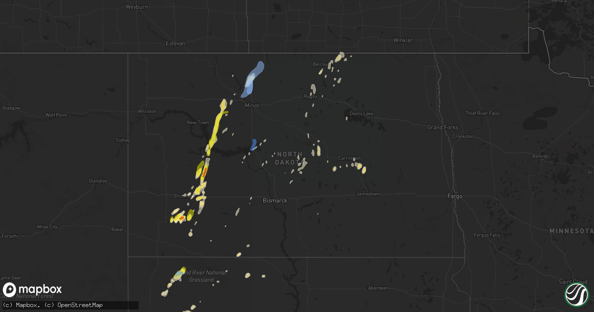
Hail Map in North Dakota on July 2, 2020
Get this storm
July 2 map
$229
one time, instant access
Download today. No call, no setup
Keep the $229
Bought the map and want the full workflow? Apply the entire $229 to a subscription within 7 days. None of it is wasted.
Every map, not just this one
This buys you this map. Subscription and you get every map we run, in the markets you choose from a few cities to whole states to nationwide. Plus real-time alerts the moment a storm fires.
Contact data
Name, contact info, occupancy, even credit band for addresses in the footprint. You go from where it hit to who to call.
Become the source they trust
Unlimited branding weather history reports on demand. You already have the documented answer ready for the property owner, and you are the one who showed up with it.
Property data and RoofTrace estimates
Pull up any address you have got, its value and the exact code rules for that jurisdiction, straight from One Click Code. Then RoofTrace estimates the squares, pitch, and roof value, priced the way you price.
Storm reports in North Dakota
North Dakota
| Date | Description |
|---|---|
| 07/02/20206:00 PM CDT | Mostly a lot of pea size hail... Ground completely covered as it hailed for quite some time... But there were some stones as big as golf balls. Hail had just stopped at |
| 07/02/20205:50 PM CDT | Intermittent hail continued until around 601 pm. Largest stones were golf ball sized. |
| 07/02/20205:28 PM CDT | Arb observer. Hail varied in size from pea to quarter. |
| 07/02/20205:17 PM CDT | A local report indicates 1.00 inch wind near 8 NW MARSHALL |
| 07/02/20204:46 PM CDT | Hail lasted 6 minutes. |
| 07/02/20204:20 PM CDT | Relayed through broadcast media. Hail lasted approximately 10 minutes. |
| 07/02/20206:05 AM CDT | Late report. Relayed by broadcast media. Time estimated from radar. |
| 07/02/20202:28 AM CDT | At 727 PM CDT, a severe thunderstorm was located 7 miles north of Coleharbor, or 9 miles east of Garrison, moving northeast at 45 mph. HAZARD...70 mph wind gusts and penny size hail. SOURCE...Radar indicated. IMPACT...Expect considerable tree damage. Damage is likely to mobile homes, roofs, and outbuildings. This severe thunderstorm will be near... Benedict around 745 PM CDT. Velva around 810 PM CDT.Other locations impacted by this severe thunderstorm include Ruso andStrawberry Lake. |
| 07/02/20202:19 AM CDT | At 717 PM CDT, a severe thunderstorm was located 5 miles southeast of Lansford, or 16 miles southeast of Mohall, moving northeast at 45 mph. HAZARD...70 mph wind gusts and nickel size hail. SOURCE...A 75 mph wind gust was measured at Minot Air Force Base. IMPACT...Expect considerable tree damage. Damage is likely to mobile homes, roofs, and outbuildings. This severe thunderstorm will be near... Maxbass around 735 PM CDT. Newburg around 745 PM CDT. Westhope around 755 PM CDT. Souris around 800 PM CDT.Other locations impacted by this severe thunderstorm include Carbury,Russell, Roth, Loraine, Landa, Grano and Eckman. |
| 07/02/20201:29 AM CDT | At 629 PM CDT, a severe thunderstorm was located near Parshall, or 30 miles southeast of Stanley, moving north at 40 mph. HAZARD...60 mph wind gusts and half dollar size hail. SOURCE...Radar indicated. IMPACT...Hail damage to vehicles is expected. Expect wind damage to roofs, siding, and trees. This severe thunderstorm will be near... Plaza around 640 PM CDT. Berthold around 715 PM CDT.Other locations impacted by this severe thunderstorm includeHartland, Coulee, Parshall Bay Recreation Area and Tagus. |
| 07/02/20201:06 AM CDT | At 606 PM CDT/506 PM MDT/, a severe thunderstorm was located 5 miles south of Marshall, or 23 miles northeast of Dickinson, moving north at 25 mph. HAZARD...Golf ball size hail and 60 mph wind gusts. SOURCE...Radar indicated. IMPACT...People and animals outdoors will be injured. Expect hail damage to roofs, siding, windows, and vehicles. Expect wind damage to roofs, siding, and trees. This severe thunderstorm will be near... Marshall around 520 PM MDT. Dodge around 550 PM MDT. Halliday around 555 PM MDT. |
| 07/02/202012:47 AM CDT | At 547 PM CDT, a severe thunderstorm was located 11 miles north of Indian Hills Recreation Area, or 33 miles west of Garrison, moving north at 55 mph. HAZARD...Golf ball size hail and 60 mph wind gusts. SOURCE...Radar indicated. IMPACT...People and animals outdoors will be injured. Expect hail damage to roofs, siding, windows, and vehicles. Expect wind damage to roofs, siding, and trees. This severe thunderstorm will be near... Parshall around 600 PM CDT. Plaza around 605 PM CDT.Other locations impacted by this severe thunderstorm include DeepWater Creek Recreation Area and Raub. |
| 07/02/202012:30 AM CDT | At 529 PM CDT/429 PM MDT/, a severe thunderstorm was located 9 miles northeast of Halliday, or 24 miles northwest of Beulah, moving north at 35 mph. HAZARD...60 mph wind gusts and quarter size hail. SOURCE...Radar indicated. IMPACT...Hail damage to vehicles is expected. Expect wind damage to roofs, siding, and trees. This severe thunderstorm will be near... Indian Hills Recreation Area around 550 PM CDT.Other locations impacted by this severe thunderstorm include DeepWater Creek Recreation Area, Twin Buttes and White Shield. |
| 07/02/202012:23 AM CDT | At 523 PM MDT, a severe thunderstorm was located 5 miles northwest of New England, or 18 miles east of Amidon, moving north at 15 mph. HAZARD...Golf ball size hail and 60 mph wind gusts. SOURCE...Radar indicated. IMPACT...People and animals outdoors will be injured. Expect hail damage to roofs, siding, windows, and vehicles. Expect wind damage to roofs, siding, and trees. This severe thunderstorm will remain over mainly rural areas of northwestern Hettinger, northeastern Slope and southwestern Stark Counties, including the following locations... Schefield. |
| 07/01/202011:56 PM CDT | At 456 PM MDT, a severe thunderstorm was located over New England, or 23 miles east of Amidon, moving north at 15 mph. HAZARD...Golf ball size hail and 60 mph wind gusts. SOURCE...Radar indicated. IMPACT...People and animals outdoors will be injured. Expect hail damage to roofs, siding, windows, and vehicles. Expect wind damage to roofs, siding, and trees. This severe thunderstorm will remain over mainly rural areas of northwestern Hettinger and southeastern Stark Counties, including the following locations... Havelock and Lefor. |
| 07/01/202011:49 PM CDT | At 449 PM CDT/349 PM MDT/, a severe thunderstorm was located over Marshall, or 23 miles southeast of Killdeer, moving north at 45 mph. HAZARD...60 mph wind gusts and half dollar size hail. SOURCE...Radar indicated. IMPACT...Hail damage to vehicles is expected. Expect wind damage to roofs, siding, and trees. This severe thunderstorm will be near... Halliday around 410 PM MDT.Other locations impacted by this severe thunderstorm include TwinButtes. |
| 07/01/202011:08 PM CDT | At 408 PM MDT, a severe thunderstorm was located 10 miles northeast of New England, or 20 miles south of Dickinson, moving north at 35 mph. HAZARD...60 mph wind gusts and half dollar size hail. SOURCE...Radar indicated. IMPACT...Hail damage to vehicles is expected. Expect wind damage to roofs, siding, and trees. This severe thunderstorm will be near... Gladstone around 440 PM MDT. Taylor around 450 PM MDT.Other locations impacted by this severe thunderstorm includeHavelock, Burt and Lefor. |
| 07/01/20209:52 PM CDT | Asos station kbis bismarck airport. |
| 07/01/20209:38 PM CDT | Ndawn station rolla 2s. |
| 07/01/20207:20 PM CDT | A local report indicates 70 MPH wind near 3 SE LANSFORD |
| 07/01/20207:12 PM CDT | Awos station kmib minot afb. 70 mph wind gust reports beginning at 7:02 pm cdt with max sustained winds at 53 mph. |
All States Impacted by Hail Map on July 2, 2020
Cities Impacted by Hail Map on July 2, 2020
- Monett, MO
- Burlington, CO
- Valentine, NE
- Alpena, AR
- Little Rock, AR
- Coldwater, MS
- Medway, ME
- Hays, KS
- Lake Village, AR
- Presho, SD
- Vivian, SD
- Scott City, KS
- Arapahoe, CO
- Sheridan Lake, CO
- Richardton, ND
- Mud Butte, SD
- Faith, SD
- Wray, CO
- Wilmar, AR
- Lansford, ND
- Glenburn, ND
- Stark, KS
- Savonburg, KS
- Dover, AR
- Rocklake, ND
- Rolla, ND
- Hansboro, ND
- Dunn Center, ND
- Taylor, ND
- Halliday, ND
- Rapid City, SD
- St John, KS
- Dodd City, TX
- Windom, TX
- Bayard, NE
- Panhandle, TX
- Gurley, NE
- Peetz, CO
- Sidney, NE
- Deer, AR
- Parshall, ND
- Roseglen, ND
- Belleville, KS
- Scandia, KS
- Concordia, KS
- Jamestown, KS
- Kilgore, NE
- Nenzel, NE
- Oakley, KS
- Hanston, KS
- Kinsley, KS
- Saint James, MO
- Chandler, OK
- Perryville, AR
- Fort Worth, TX
- Gregory, SD
- Bethune, CO
- Carl Junction, MO
- Joplin, MO
- Webb City, MO
- Monticello, AR
- Grady, AR
- Fairfax, OK
- Pierce City, MO
- Hill City, SD
- Keystone, SD
- Goodland, KS
- Clarksville, AR
- Lamar, AR
- Prairie City, SD
- Cope, CO
- Anton, CO
- Buena Vista, GA
- Union Center, SD
- Newell, SD
- Bird City, KS
- Saint Francis, KS
- Benkelman, NE
- Gladstone, ND
- Hemingford, NE
- Lamar, CO
- Wiley, CO
- Hasty, CO
- McClave, CO
- Harvey, ND
- Chaseley, ND
- Bowdon, ND
- Burr Oak, KS
- Tupelo, OK
- De Witt, AR
- Greenville, MS
- Leland, MS
- Bentonia, MS
- Newcastle, WY
- Hermosa, SD
- Oberon, ND
- Springdale, AR
- Oral, SD
- Pine Ridge, SD
- Champion, NE
- Carpio, ND
- Salina, KS
- Alexander, AR
- Mabelvale, AR
- Bauxite, AR
- Howes, SD
- Pierre, SD
- Blunt, SD
- Guide Rock, NE
- Searcy, AR
- Hugo, OK
- Rison, AR
- Lake Wales, FL
- Atwood, KS
- Selden, KS
- Hoxie, KS
- Rexford, KS
- Lexington, MS
- Cruger, MS
- Sturgis, SD
- Mulberry, AR
- Ryan, OK
- Crawford, NE
- Dumas, AR
- Healy, KS
- Grinnell, KS
- Ogallala, NE
- Paxton, NE
- Keystone, NE
- Harrison, AR
- Rolette, ND
- Rugby, ND
- White Owl, SD
- Whitman, NE
- Max, NE
- Lincoln, KS
- Sylvan Grove, KS
- Drumright, OK
- Dresden, KS
- Yale, OK
- Regent, ND
- Hettinger, ND
- Colby, KS
- Garden City, KS
- Leslie, AR
- Dickinson, ND
- New England, ND
- Amidon, ND
- Midland, SD
- Draper, SD
- Fort Pierre, SD
- Okaton, SD
- Murdo, SD
- Hayes, SD
- Satanta, KS
- Berthold, ND
- Lindsborg, KS
- Assaria, KS
- Reva, SD
- Edson, KS
- Utica, KS
- Hominy, OK
- Vale, SD
- Madison, ME
- Sarah, MS
- Crenshaw, MS
- Indianola, MS
- Hollandale, MS
- Inverness, MS
- Stratton, CO
- Cody, NE
- Tuthill, SD
- Saint Francis, SD
- Aladdin, WY
- Marsland, NE
- Rogers, AR
- Yazoo City, MS
- Glenpool, OK
- Phillips, WI
- Lebanon, NE
- Shaw, MS
- Doddsville, MS
- Kensal, ND
- Booneville, AR
- Ponca, AR
- Garfield, KS
- Belpre, KS
- Larned, KS
- Guymon, OK
- Chamberlain, SD
- England, AR
- Pine Bluff, AR
- Cherry Creek, SD
- Philip, SD
- Milesville, SD
- Miller, SD
- Lakin, KS
- Belzoni, MS
- Crookston, NE
- Shell Knob, MO
- Washburn, ND
- Hayes Center, NE
- Mountain View, AR
- Magazine, AR
- Thedford, NE
- Pawhuska, OK
- Shidler, OK
- Burbank, OK
- Granada, CO
- Berryville, AR
- Hudson, KS
- Maple City, KS
- Dexter, KS
- Herndon, KS
- Hernando, MS
- Lyon, MS
- Clarksdale, MS
- Silver City, MS
- Hudson, ME
- Spencer, NE
- Oneill, NE
- Waxahachie, TX
- Cedar Hill, TX
- Midlothian, TX
- McIntosh, SD
- McLaughlin, SD
- Kanorado, KS
- Victoria, KS
- Walker, KS
- Gorham, KS
- Wood, SD
- Tulsa, OK
- Sapulpa, OK
- Sand Springs, OK
- Belleville, AR
- Danville, AR
- Plaza, ND
- Ryder, ND
- Killdeer, ND
- Green Forest, AR
- Abilene, KS
- Solomon, KS
- Minter City, MS
- Charleston, MS
- Akron, CO
- Bolton, MS
- Wasta, SD
- Enning, SD
- Winner, SD
- Hamill, SD
- Wauneta, NE
- Stratton, NE
- Oxford, MS
- Water Valley, MS
- Tutwiler, MS
- Imperial, NE
- Enders, NE
- Superior, NE
- Dundee, MS
- Sledge, MS
- Isola, MS
- Mankato, KS
- Yellville, AR
- Caputa, SD
- Holdenville, OK
- Wetumka, OK
- Parthenon, AR
- Woodworth, ND
- Sheridan, AR
- Warren, AR
- Elkhart, KS
- Jenks, OK
- Pittsboro, MS
- Tillar, AR
- Perth, ND
- Vernon, CO
- Weskan, KS
- Parks, NE
- Sterling, CO
- Kress, TX
- Red Oak, TX
- Otis, KS
- Pfeifer, KS
- Russell, KS
- Jetmore, KS
- Ellis, KS
- Scenic, SD
- New Salem, ND
- Dighton, KS
- Milburn, OK
- Kenefic, OK
- Brewster, KS
- Eagle Butte, SD
- Dupree, SD
- Lantry, SD
- Gove, KS
- Aurora, MO
- Reeds Spring, MO
- Brinkley, AR
- Hamburg, AR
- Pittsburg, KS
- Asbury, MO
- Coleharbor, ND
- Milo, ME
- Seligman, MO
- Garfield, AR
- Eagle Rock, MO
- Keller, TX
- Elkins, AR
- Fayetteville, AR
- Weleetka, OK
- Bassett, NE
- Bridgeport, NE
- Angora, NE
- Batesville, AR
- Portales, NM
- Wessington Springs, SD
- Gypsum, KS
- Cape Fair, MO
- Beeler, KS
- Sterling, KS
- Omaha, AR
- Mounds, OK
- Pritchett, CO
- Okemah, OK
- Seminole, OK
- Sarcoxie, MO
- Selfridge, ND
- Mayersville, MS
- Carrington, ND
- Brownell, KS
- McCracken, KS
- Burdett, KS
- Cherokee, KS
- Weir, KS
- Cushing, OK
- Poteau, OK
- Meadow, SD
- Joes, CO
- Vona, CO
- Kirk, CO
- Senatobia, MS
- Coahoma, MS
- Gordon, NE
- Columbus, KS
- Hollister, MO
- Bisbee, ND
- Knox, ND
- Hugoton, KS
- Moscow, KS
- Glencoe, OK
- Sarles, ND
- Lefor, ND
- Kinta, OK
- Park, KS
- Quinter, KS
- Wisner, LA
- Morland, KS
- Denhoff, ND
- Goodrich, ND
- Merigold, MS
- Ruleville, MS
- Cleveland, MS
- Ferriday, LA
- Dardanelle, AR
- Sahuarita, AZ
- Hazen, ND
- Stanton, ND
- Culbertson, NE
- Carthage, MO
- Reeds, MO
- Bixby, OK
- Stuart, NE
- Lenora, KS
- Stillwater, OK
- Mccurtain, OK
- Great Bend, KS
- Jefferson, AR
- Penokee, KS
- Hill City, KS
- Huntsville, AR
- Harmony, ME
- Hunter, KS
- Belcourt, ND
- Curtis, NE
- Snow Lake, AR
- Watson, AR
- Merriman, NE
- Lodgepole, SD
- Hagarville, AR
- Altus, AR
- Ozark, AR
- Hartman, AR
- Houlton, ME
- Cassville, MO
- Carson, ND
- Uniontown, KS
- Golden, MO
- Bisbee, AZ
- Tombstone, AZ
- Thorndike, ME
- Troy, ME
- Harrison, NE
- Oark, AR
- Redfield, AR
- Madrid, NE
- Galena, MO
- Potter, NE
- Portis, KS
- Oronogo, MO
- Paris, AR
- Claude, TX
- Troy, NY
- Dalton, NE
- Eustis, NE
- Lowell, AR
- Stafford, KS
- Lewis, KS
- Macksville, KS
- Branson, MO
- Okmulgee, OK
- Gann Valley, SD
- Downs, KS
- Long Pine, NE
- Dustin, OK
- Belvidere, SD
- Winona, KS
- Monument, KS
- Marienthal, KS
- Holly, CO
- Ruso, ND
- Benedict, ND
- Grant, NE
- Bingham, ME
- Ralston, OK
- Buffalo, SD
- Duncan, MS
- Anderson, MO
- Pineville, MO
- Bristow, OK
- Valley Springs, AR
- Lampe, MO
- Anson, ME
- Newton, KS
- Mylo, ND
- Fairfield, ME
- Gainesville, MO
- Wing, ND
- Galena, KS
- Ponca City, OK
- Martin, SD
- Stuart, FL
- Indiantown, FL
- Osborne, KS
- Cuba, MO
- Pawnee, OK
- Benton, AR
- Ellinwood, KS
- Portland, AR
- Waterford, NY
- Mechanicville, NY
- Beloit, KS
- Tribune, KS
- Elgin, ND
- Ulysses, KS
- Sublette, KS
- Kingsland, AR
- Bearden, AR
- Sherman, ME
- Eureka Springs, AR
- Plainview, AR
- Humphrey, AR
- Louise, MS
- Anguilla, MS
- Wall, SD
- Marietta, OK
- Waterville, ME
- Chapman, KS
- Saint Bernard, LA
- Helena, AR
- Drew, MS
- Scranton, AR
- Turtle Lake, ND
- Ripley, OK
- Beggs, OK
- Pea Ridge, AR
- Oviedo, FL
- Orlando, FL
- Minneapolis, KS
- Grapevine, AR
- Island Falls, ME
- Wasola, MO
- Glen Allan, MS
- Chatham, MS
- McCook, NE
- Maywood, NE
- Mansfield, TX
- Girard, KS
- Maypearl, TX
- Venus, TX
- Napoleon, ND
- Lamar, OK
- Barnard, KS
- Jasper, AR
- Perkins, OK
- Coalgate, OK
- Athens, ME
- Sundance, WY
- Marble Falls, AR
- Marks, MS
- Shelby, MS
- Mound Bayou, MS
- Hindsville, AR
- Tryon, OK
- Brookston, TX
- Moundridge, KS
- Ransom, KS
- Miami, OK
- Kingston, AR
- Roxton, TX
- Milford, KS
- Bradford, AR
- Saint Lawrence, SD
- Johnson, KS
- Chadwick, MO
- Almont, ND
- Hurdsfield, ND
- Makoti, ND
- Plainville, KS
- Langdon, ND
- Barnsdall, OK
- White Hall, AR
- Ivan, AR
- Pingree, ND
- Pleasant Grove, AR
- Ennis, TX
- Hensley, AR
- Prosper, TX
- Oberlin, KS
- Red Rock, OK
- Como, MS
- North Anson, ME
- Chestnutridge, MO
- Walnut Shade, MO
- Hanna, OK
- Brookville, KS
- New Underwood, SD
- Newport, AR
- Verona, MO
- Purdy, MO
- Esbon, KS
- Augusta, AR
- Fort Lauderdale, FL
- Fordyce, AR
- Gould, AR
- Sicily Island, LA
- Flippin, AR
- Compton, AR
- Waldron, AR
- Wapanucka, OK
- Pickens, AR
- Bartley, NE
- Indianola, NE
- Hermleigh, TX
- Holyrood, KS
- Claflin, KS
- Freistatt, MO
- Gunnison, MS
- Fairfax, SD
- Butte, NE
- Washburn, MO
- Banks, AR
- Whitney, NE
- Clinton, AR
- Cooper, TX
- Gentry, AR
- Cave City, AR
- Trenton, NE
- Regan, ND
- Red Oak, OK
- Ethel, AR
- Canton, MS
- Heavener, OK
- Howe, OK
- Lancaster, TX
- Noel, MO
- Tolley, ND
- Gravette, AR
- Tucker, AR
- Black Hawk, SD
- Mercer, ND
- Natoma, KS
- Bogalusa, LA
- Woodbine, KS
- Burden, KS
- Winfield, KS
- Tipton, KS
- Pomona, MO
- Wesley, AR
- Sherrill, AR
- Sumner, TX
- Piedmont, SD
- Reliance, SD
- Broken Arrow, OK
- Coal Hill, AR
- Ellsworth, KS
- Dallas, TX
- Duncanville, TX
- Deadwood, SD
- Muenster, TX
- Solon, ME
- Allen, OK
- Protem, MO
- Silverton, TX
- Oacoma, SD
- New Edinburg, AR
- Gassville, AR
- Mission, SD
- Moro, AR
- Sylvia, KS
- Kanopolis, KS
- Erie, KS
- Agra, OK
- Benedicta, ME
- Kiefer, OK
- Abbyville, KS
- Plevna, KS
- Mount Vernon, AR
- Lebanon, KS
- Subiaco, AR
- Keldron, SD
- Holly Grove, AR
- Muleshoe, TX
- Havana, AR
- New Blaine, AR
- Oak Grove, LA
- Arlington, KS
- Turon, KS
- Magee, MS
- Mount Olive, MS
- Palmer, TX
- Ferris, TX
- New Braintree, MA
- Barre, MA
- Oakham, MA
- Jennings, KS
- Gem, KS
- Logan, KS
- Norcatur, KS
- Clayton, KS
- Levant, KS
- Norton, KS
- Long Island, KS
- Prairie View, KS
- Almena, KS
- Delphos, KS
- Glasco, KS
- Halstead, KS
- Sedgwick, KS
- Haysville, KS
- Belle Plaine, KS
- Mulvane, KS
- Derby, KS
- Peck, KS
- Dodge, ND
- Max, ND
- Minot Afb, ND
- Westhope, ND
- Burlington, ND
- Maxbass, ND
- Minot, ND
- Lincoln, MA
- Waltham, MA
- Weston, MA
- Custer, SD


