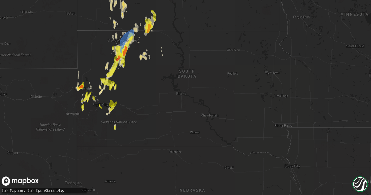
Hail Map in South Dakota on June 29, 2020
Get this storm
June 29 map
$229
one time, instant access
Download today. No call, no setup
Keep the $229
Bought the map and want the full workflow? Apply the entire $229 to a subscription within 7 days. None of it is wasted.
Every map, not just this one
This buys you this map. Subscription and you get every map we run, in the markets you choose from a few cities to whole states to nationwide. Plus real-time alerts the moment a storm fires.
Contact data
Name, contact info, occupancy, even credit band for addresses in the footprint. You go from where it hit to who to call.
Become the source they trust
Unlimited branding weather history reports on demand. You already have the documented answer ready for the property owner, and you are the one who showed up with it.
Property data and RoofTrace estimates
Pull up any address you have got, its value and the exact code rules for that jurisdiction, straight from One Click Code. Then RoofTrace estimates the squares, pitch, and roof value, priced the way you price.
Storm reports in South Dakota
South Dakota
| Date | Description |
|---|---|
| 06/29/20206:40 PM CDT | A local report indicates 1.50 inch wind near 8 NNE HEREFORD |
| 06/29/20206:25 PM CDT | A local report indicates 1.00 inch wind near 7 SE CHEYENNE CROSSING |
| 06/29/20205:55 PM CDT | A local report indicates 1.00 inch wind near 7 SW STURGIS |
| 06/29/20205:25 PM CDT | A local report indicates 1.00 inch wind near 6 SSE BROWNSVILLE |
| 06/29/20206:57 AM CDT | At 1156 PM MDT, severe thunderstorms were located along a line extending from 3 miles southeast of Date to 11 miles northeast of Opal, moving north at 25 mph. HAZARD...Ping pong ball size hail and 60 mph wind gusts. SOURCE...Radar indicated. IMPACT...People and animals outdoors will be injured. Expect hail damage to roofs, siding, windows, and vehicles. Expect wind damage to roofs, siding, and trees. Severe thunderstorms will be near... Date around 1205 AM MDT. Usta around 1230 AM MDT. Bison around 1235 AM MDT. Chance around 100 AM MDT. |
| 06/29/20204:20 AM CDT | At 919 PM MDT, a severe thunderstorm was located over Dalton Lake, or 10 miles south of Sturgis, moving northwest at 20 mph. HAZARD...Quarter size hail. SOURCE...Radar indicated. IMPACT...Damage to vehicles is expected. This severe thunderstorm will be near... Sturgis and Fort Meade around 945 PM MDT.This includes Interstate 90 in South Dakota between Mile Markers 31and 47. |
| 06/29/20204:09 AM CDT | At 908 PM MDT, a severe thunderstorm was located 7 miles southeast of Mud Butte, or 36 miles west of Faith, moving northeast at 25 mph. HAZARD...Golf ball size hail and 60 mph wind gusts. SOURCE...Radar indicated. IMPACT...People and animals outdoors will be injured. Expect hail damage to roofs, siding, windows, and vehicles. Expect wind damage to roofs, siding, and trees. This severe thunderstorm will be near... Maurine around 930 PM MDT. Date around 1015 PM MDT. |
| 06/29/20204:03 AM CDT | At 903 PM MDT, a severe thunderstorm was located 4 miles southeast of New Underwood, or 23 miles east of Rapid City, moving north at 25 mph. HAZARD...Quarter size hail. SOURCE...Radar indicated. IMPACT...Damage to vehicles is expected. This severe thunderstorm will be near... Viewfield around 925 PM MDT. Curlew Lake around 935 PM MDT. Elm Springs around 945 PM MDT.This includes Interstate 90 in South Dakota between Mile Markers 76and 90. |
| 06/29/20203:59 AM CDT | At 859 PM MDT, a severe thunderstorm was located over southeastern Rapid City, moving north at 20 mph. HAZARD...Quarter size hail. SOURCE...Radar indicated. IMPACT...Damage to vehicles is expected. Locations impacted include... Rapid City, Rapid Valley, northwestern Ellsworth Air Force Base, southwestern Box Elder, Summerset, Black Hawk, Bear Country, Hart Ranch, Black Gap and Reptile Gardens.This includes Interstate 90 in South Dakota between Mile Markers 48and 65. |
| 06/29/20203:36 AM CDT | At 836 PM MDT, a severe thunderstorm was located 7 miles northwest of Fairpoint, or 40 miles northeast of Sturgis, moving north at 25 mph. HAZARD...Half dollar size hail. SOURCE...Radar indicated. IMPACT...Damage to vehicles is expected. This severe thunderstorm will be near... Mud Butte around 905 PM MDT. |
| 06/29/20202:54 AM CDT | At 754 PM MDT, a severe thunderstorm was located over New Underwood, or 19 miles east of Rapid City, moving north at 10 mph. HAZARD...Half dollar size hail. SOURCE...Radar indicated. IMPACT...Damage to vehicles is expected. This severe thunderstorm will be near... Viewfield around 840 PM MDT. Curlew Lake around 845 PM MDT.This includes Interstate 90 in South Dakota between Mile Markers 71and 86. |
| 06/29/20202:50 AM CDT | A local report indicates 1.00 inch wind near SHADEHILL |
| 06/29/20201:58 AM CDT | At 658 PM MDT, a severe thunderstorm was located over Union Center, or 42 miles east of Sturgis, moving north at 20 mph. HAZARD...Half dollar size hail. SOURCE...Radar indicated. IMPACT...Damage to vehicles is expected. Locations impacted include... Union Center, Enning, Opal, Red Owl and Stoneville. |
| 06/29/20201:55 AM CDT | A local report indicates 60 MPH wind near 7 SSE BISON |
| 06/29/20201:55 AM CDT | A local report indicates 1.75 inch wind near 7 SSE BISON |
| 06/29/20201:35 AM CDT | A local report indicates 60 MPH wind near 8 WNW USTA |
| 06/29/20201:32 AM CDT | At 632 PM MDT, a severe thunderstorm was located near Brownsville, or 4 miles southeast of Lead, moving north at 30 mph. HAZARD...Half dollar size hail. SOURCE...Radar indicated. IMPACT...Damage to vehicles is expected. Locations impacted include... Southeastern Spearfish, northwestern Sturgis, Lead, Deadwood, Whitewood, Saint Onge, Central City, Galena, Brownsville, Apple Springs, Roubaix Lake and Terry Peak.This includes Interstate 90 in South Dakota between Mile Markers 14and 30. |
| 06/29/20201:29 AM CDT | At 629 PM MDT, a severe thunderstorm was located 9 miles east of Owl Butte, or 29 miles northeast of Sturgis, moving northwest at 20 mph. HAZARD...Quarter size hail. SOURCE...Radar indicated. IMPACT...Damage to vehicles is expected. Locations impacted include... Owl Butte. |
| 06/29/20201:24 AM CDT | At 624 PM MDT, a severe thunderstorm was located 9 miles west of Rockyford, or 34 miles north of Pine Ridge, moving north at 15 mph. HAZARD...60 mph wind gusts and half dollar size hail. SOURCE...Radar indicated. IMPACT...Hail damage to vehicles is expected. Expect wind damage to roofs, siding, and trees. Locations impacted include... Scenic, southwestern Badlands National Park and Sheep Mountain Table. |
| 06/29/20201:12 AM CDT | At 611 PM MDT, a severe thunderstorm was located 7 miles south of Fairpoint, or 38 miles northeast of Sturgis, moving north at 25 mph. HAZARD...60 mph wind gusts and quarter size hail. SOURCE...Radar indicated. IMPACT...Hail damage to vehicles is expected. Expect wind damage to roofs, siding, and trees. Locations impacted include... Fairpoint, Maurine, Mud Butte and Stoneville. |
| 06/29/20201:10 AM CDT | At 610 PM MDT, a severe thunderstorm was located 3 miles southeast of Prairie City, or 35 miles south of Hettinger, moving north at 15 mph. HAZARD...Ping pong ball size hail and 60 mph wind gusts. SOURCE...Radar indicated. IMPACT...People and animals outdoors will be injured. Expect hail damage to roofs, siding, windows, and vehicles. Expect wind damage to roofs, siding, and trees. Locations impacted include... Lodgepole and Prairie City. |
| 06/29/20201:05 AM CDT | At 604 PM MDT, a severe thunderstorm was located 5 miles south of Deerfield, or 13 miles west of Hill City, moving north at 30 mph. HAZARD...Quarter size hail. SOURCE...Radar indicated. IMPACT...Damage to vehicles is expected. Locations impacted include... Rochford, Flag Mountain, Deerfield, Deerfield Reservoir, Crooks Tower and Black Fox Campground. |
| 06/29/202012:44 AM CDT | At 543 PM MDT, a severe thunderstorm was located near Brownsville, or 6 miles south of Lead, moving northeast at 15 mph. HAZARD...Quarter size hail. SOURCE...Radar indicated. IMPACT...Damage to vehicles is expected. Locations impacted include... Lead, Deadwood, Whitewood, Central City, Galena, Brownsville, Apple Springs, Roubaix Lake and Terry Peak.This includes Interstate 90 in South Dakota between Mile Markers 17and 18, and between Mile Markers 24 and 28. |
| 06/29/202012:41 AM CDT | At 541 PM MDT, severe thunderstorms were located along a line extending from Fairpoint to 6 miles north of Hereford, moving north at 30 mph. HAZARD...60 mph wind gusts and quarter size hail. SOURCE...Radar indicated. IMPACT...Hail damage to vehicles is expected. Expect wind damage to roofs, siding, and trees. Locations impacted include... Fairpoint and Stoneville. |
| 06/29/202012:01 AM CDT | At 500 PM MDT, a severe thunderstorm was located over Black Fox Campground, or 14 miles south of Lead, moving north at 15 mph. HAZARD...Quarter size hail. SOURCE...Radar indicated. IMPACT...Damage to vehicles is expected. Locations impacted include... Lead, Deadwood, Central City, Cheyenne Crossing, Brownsville, Crooks Tower, Black Fox Campground, Roughlock Falls, Savoy, Bridal Veil Falls, Terry Peak and Spearfish Canyon. |
| 06/28/202011:53 PM CDT | At 453 PM MDT, a severe thunderstorm was located 3 miles east of Galena, or 6 miles southwest of Sturgis, moving northeast at 15 mph. HAZARD...Quarter size hail. SOURCE...Radar indicated. IMPACT...Damage to vehicles is expected. This severe thunderstorm will be near... Apple Springs around 505 PM MDT. Sturgis and Fort Meade around 520 PM MDT. Bear Butte State Park around 545 PM MDT.This includes Interstate 90 in South Dakota between Mile Markers 26and 38. |
| 06/28/202011:35 PM CDT | A local report indicates 60 MPH wind near BISON |
| 06/28/202011:14 PM CDT | At 414 PM MDT, a severe thunderstorm was located over Roubaix Lake, or 13 miles southeast of Lead, moving northeast at 15 mph. HAZARD...Ping pong ball size hail. SOURCE...Radar indicated. IMPACT...People and animals outdoors will be injured. Expect damage to roofs, siding, windows, and vehicles. Locations impacted include... Nemo, Brownsville, Galena, Dalton Lake and Roubaix Lake. This includes Interstate 90 in South Dakota between Mile Markers 38and 39. |
| 06/28/202011:10 PM CDT | A local report indicates 1.00 inch wind near 15 SSW BISON |
| 06/28/202010:56 PM CDT | Trees down on bixby road |
| 06/28/202010:30 PM CDT | A local report indicates 1.00 inch wind near 1 W TILFORD |
| 06/28/202010:05 PM CDT | A local report indicates 60 MPH wind near 7 E NEW UNDERWOOD |
| 06/28/202010:05 PM CDT | A local report indicates 60 MPH wind near 10 SSE MUD BUTTE |
| 06/28/202010:03 PM CDT | A local report indicates 1.00 inch wind near 2 SSW DWTN RAPID CITY |
| 06/28/202010:02 PM CDT | A local report indicates 1.00 inch wind near 4 S DWTN RAPID CITY |
| 06/28/20209:50 PM CDT | A local report indicates 1.00 inch wind near 8 NE LODGEPOLE |
| 06/28/20209:45 PM CDT | A local report indicates 1.50 inch wind near DWTN SPEARFISH |
| 06/28/20209:43 PM CDT | A local report indicates 1.00 inch wind near 1 SE DWTN SPEARFISH |
| 06/28/20209:36 PM CDT | A local report indicates 1.00 inch wind near 3 WNW DWTN SPEARFISH |
| 06/28/20209:35 PM CDT | A local report indicates 1.00 inch wind near 2 W DWTN SPEARFISH |
| 06/28/20209:35 PM CDT | A local report indicates 1.75 inch wind near 2 WNW DWTN SPEARFISH |
| 06/28/20209:10 PM CDT | A local report indicates 1.00 inch wind near 3 ESE NEW UNDERWOOD |
| 06/28/20209:05 PM CDT | A local report indicates 60 MPH wind near 3 ESE NEW UNDERWOOD |
| 06/28/20208:00 PM CDT | A local report indicates 60 MPH wind near 8 S UNION CENTER |
| 06/28/20207:47 PM CDT | A local report indicates 1.25 inch wind near 2 NNE BROWNSVILLE |
| 06/28/20207:45 PM CDT | A local report indicates 1.00 inch wind near 3 ENE PRAIRIE CITY |
| 06/28/20207:20 PM CDT | A local report indicates 1.00 inch wind near 1 NE DEERFIELD |
| 06/28/20207:20 PM CDT | A local report indicates 1.25 inch wind near 6 NW UNION CENTER |
| 06/28/20207:10 PM CDT | A local report indicates 1.00 inch wind near 3 SW BROWNSVILLE |
All States Impacted by Hail Map on June 29, 2020
Cities Impacted by Hail Map on June 29, 2020
- Meadow, SD
- Dupree, SD
- Caputa, SD
- New Underwood, SD
- Albany, TX
- Dundee, IL
- New Haven, IL
- Ridgway, IL
- New Paltz, NY
- Alva, WY
- Seymour, IN
- Comstock, TX
- Belle Fourche, SD
- Beulah, WY
- Saint Onge, SD
- Spearfish, SD
- Ozona, TX
- Bison, SD
- Gallatin, TN
- Bethpage, TN
- Portland, TN
- Castalian Springs, TN
- Oshkosh, WI
- Winneconne, WI
- Glendive, MT
- Sundance, WY
- Raleigh, ND
- Watauga, SD
- New Leipzig, ND
- Shields, ND
- Morristown, SD
- Selfridge, ND
- Carson, ND
- Jacksonville, VT
- Colrain, MA
- Union Grove, WI
- Kenosha, WI
- Lueders, TX
- Stamford, TX
- Avoca, TX
- Plentywood, MT
- Clarksville, TN
- Deadwood, SD
- Nemo, SD
- Old Lyme, CT
- Montgomery, NY
- Walden, NY
- Union Center, SD
- Ovalo, TX
- Tuscola, TX
- Williamsburg, KY
- Newell, SD
- Madison, WI
- Killdeer, ND
- Fairfield, ND
- Watford City, ND
- Grassy Butte, ND
- Arnegard, ND
- Cartwright, ND
- Highland, NY
- Tillson, NY
- Ulster Park, NY
- Brooklyn, NY
- Outlook, MT
- Wibaux, MT
- Johnson Creek, WI
- Watertown, WI
- Granville, MA
- Sandisfield, MA
- Waddy, KY
- Shelbyville, KY
- Plaza, ND
- Lemmon, SD
- Belleville, WI
- New Glarus, WI
- Keene, ND
- Monon, IN
- Rensselaer, IN
- Birmingham, AL
- Norton, TX
- Winters, TX
- Bronte, TX
- Whitewood, SD
- Colebrook, CT
- Winsted, CT
- Knoxville, TN
- Prospect, TN
- Prairie City, SD
- Faith, SD
- Wingate, TX
- Blackwell, TX
- Flasher, ND
- Vale, SD
- Sturgis, SD
- Port Orange, FL
- Edgerton, WI
- Janesville, WI
- Venus, FL
- Lake Placid, FL
- Moorcroft, WY
- Louisville, KY
- Charlemont, MA
- Ashfield, MA
- Hazel Green, AL
- Meridianville, AL
- Toney, AL
- Huntsville, AL
- New Market, AL
- Ohatchee, AL
- Brooklyn, WI
- Mott, ND
- Estill Springs, TN
- Hill City, SD
- Redgranite, WI
- Neshkoro, WI
- Colchester, CT
- Lebanon, CT
- Upton, WY
- East Lyme, CT
- Pelzer, SC
- Malvern, AR
- Donaldson, AR
- Kansasville, WI
- Mundelein, IL
- Lake Zurich, IL
- Dickinson, ND
- New England, ND
- Lead, SD
- Scottsburg, IN
- Wilmington, IL
- Channahon, IL
- Mud Butte, SD
- Niantic, CT
- Orient, NY
- Fort Payne, AL
- Mentone, AL
- Gibbon, MN
- Winthrop, MN
- Barrington, IL
- Palatine, IL
- Hoffman Estates, IL
- Richardton, ND
- Robert Lee, TX
- Elgin, IL
- Carpentersville, IL
- Manning, ND
- Easley, SC
- Piedmont, SC
- Pine Ridge, SD
- Greenville, WI
- Sheridan, AR
- Abilene, TX
- Beach, ND
- Medora, ND
- Belfield, ND
- Belleville, IL
- O'Fallon, IL
- Traskwood, AR
- Poyen, AR
- Hulett, WY
- Sopchoppy, FL
- Cliffside Park, NJ
- Fort Lee, NJ
- Englewood, NJ
- Breezy Point, NY
- Tenafly, NJ
- Edgewater, NJ
- Leonia, NJ
- Astoria, NY
- Palisades Park, NJ
- Englewood Cliffs, NJ
- New York, NY
- Long Island City, NY
- North Bergen, NJ
- Bergenfield, NJ
- Stoughton, WI
- Piedmont, SD
- Berlin, WI
- Pine River, WI
- Whitewater, WI
- Rockford, IL
- Eubank, KY
- Science Hill, KY
- Redstone, MT
- Tye, TX
- Dyess Afb, TX
- Crawfordsville, IN
- Middleton, WI
- Homestead, MT
- Osage, WY
- Newcastle, WY
- Clintondale, NY
- Modena, NY
- Timber Lake, SD
- Ellington, CT
- Holdingford, MN
- Albany, MN
- Grey Eagle, MN
- Bowlus, MN
- Burtrum, MN
- Upsala, MN
- Neillsville, WI
- Raymond, MT
- Barnhart, TX
- Reeder, ND
- Aladdin, WY
- Greenwood, IN
- Dunn Center, ND
- Rapid City, SD
- Black Hawk, SD
- Enning, SD
- Accord, NY
- Peotone, IL
- Union, IL
- Woodstock, IL
- Merkel, TX
- Wallkill, NY
- Adams, TN
- Rockford, TN
- Dyer, IN
- Crown Point, IN
- Cedar Lake, IN
- Saint John, IN
- Schererville, IN
- Gladstone, ND
- Taylor, ND
- Prospect, KY
- Charlestown, IN
- Jeffersonville, IN
- Valparaiso, IN
- Milton, KY
- Blanchardville, WI
- Freeburg, IL
- Mascoutah, IL
- Storrs Mansfield, CT
- Mansfield Center, CT
- Goshen, KY
- Crestwood, KY
- Verona, WI
- New Bedford, MA
- South Dartmouth, MA
- North Dartmouth, MA
- Elizabethtown, IL
- Capron, IL
- Poplar Grove, IL
- Hull, IL
- Bardstown, KY
- Liberty, KY
- Coventry, CT
- Pell City, AL
- Eight Mile, AL
- Saraland, AL
- Roselle, IL
- Schaumburg, IL
- Pine Bush, NY
- Regent, ND
- Eagle Bend, MN
- South Wayne, WI
- Argyle, WI
- Ferryville, WI
- Colfax, IN
- Darlington, IN
- Bradfordsville, KY
- Lawn, TX
- Wolcott, IN
- Whiteland, IN
- Franklin, IN
- North Port, FL
- Blue Mounds, WI
- Black Earth, WI
- Monroe, WI
- Albany, WI
- Monticello, WI
- Mulberry Grove, IL
- Barneveld, WI
- Mattapoisett, MA
- Fairhaven, MA
- Acushnet, MA
- New Town, ND
- Richmond, IL
- Twin Lakes, WI
- Spring Grove, IL
- Ringwood, IL
- Mchenry, IL
- Rosendale, NY
- Gardiner, NY
- Newburgh, NY
- Marlboro, NY
- Cottontown, TN
- Sullivan, WI
- Jefferson, WI
- Helenville, WI
- Collinsville, AL
- Cedar Bluff, AL
- Leesburg, AL
- Clyde, TX
- Chattanooga, TN
- Donnybrook, ND
- Shepherdsville, KY
- Rock Spring, GA
- La Fayette, GA
- Mandaree, ND
- Lefor, ND
- Tunnel Hill, GA
- Ringgold, GA
- Mount Horeb, WI
- Cross Plains, WI
- Lake Crystal, MN
- Burlington, WI
- Francesville, IN
- Lebanon, IN
- Butte Des Morts, WI
- Bowling Green, FL
- Bartow, FL
- Fort Meade, FL
- Swanville, MN
- Little Falls, MN
- Lodgepole, SD
- Sharon, WI
- Bourbonnais, IL
- Hettinger, ND
- Rowe, MA
- Eagle, WI
- Belvidere, IL
- Caledonia, IL
- Bethelridge, KY
- Belton, SC
- Olivebridge, NY
- Loogootee, IN
- Gary, IN
- Hebron, IN
- Lowell, IN
- Pleasant Shade, TN
- Dixon Springs, TN
- Lafayette, TN
- Devils Tower, WY
- Marengo, IL
- Mertzon, TX
- Mount Washington, KY
- Hampshire, IL
- Fulda, MN
- Simpsonville, SC
- Fountain Inn, SC
- Falls Village, CT
- Frankfort, IN
- Crothersville, IN
- Omro, WI
- Larsen, WI
- Lansing, IL
- Calumet City, IL
- Hammond, IN
- Oregon, WI
- Austin, IN
- Bristol, WI
- Rockton, IL
- Stone Ridge, NY
- Louisville, TN
- Jamestown, TN
- Minooka, IL
- Marshfield, WI
- Monee, IL
- Braidwood, IL
- Coal City, IL
- Morris, IL
- Manhattan, IL
- Bedford, KY
- Spring Green, WI
- Darlington, WI
- Mineral Point, WI
- Shullsburg, WI
- Edgefield, SC
- Johnston, SC
- Saluda, SC
- Ward, SC
- Browerville, MN
- Cedar Hill, TN
- Springfield, KY
- Hermosa, SD
- Hollandale, WI
- East Haddam, CT
- Evansville, WI
- Millstadt, IL
- Clanton, AL
- Jefferson, AR
- White Hall, AR
- Lansing, IA
- Lafayette, IN
- Fishers, IN
- Keldron, SD
- Lynchburg, OH
- Sardinia, OH
- Auburndale, FL
- Lake Alfred, FL
- Parsons, KS
- Fort Myers, FL
- Griffith, IN
- Crete, IL
- Gurley, AL
- Hot Springs National Park, AR
- Pulaski, TN
- Scottsboro, AL
- Black River Falls, WI
- Madelia, MN
- Hanska, MN
- Saint James, MN
- Pewaukee, WI
- Harvard, IL
- Kerhonkson, NY
- Altheimer, AR
- Attica, IN
- Williamsport, IN
- La Grange, KY
- Westport, KY
- Montello, WI
- Loretto, KY
- Winamac, IN
- Morgantown, IN
- Stevenson, AL
- Scipio, IN
- Lakeland, FL
- Clayton, IN
- Golconda, IL
- Pecatonica, IL
- Durand, IL
- Isabel, SD
- Halliday, ND
- Prattsville, AR
- Endeavor, WI
- Springfield, TN
- White House, TN
- Greenbrier, TN
- Labelle, FL
- Mukwonago, WI
- Mazon, IL
- Wilsonville, AL
- Beulah, ND
- Bloomingdale, IL
- Elk Grove Village, IL
- Medinah, IL
- Itasca, IL
- Coleman, TX
- Goldsboro, TX
- Grantsburg, WI
- Sturgis, KY
- Morganfield, KY
- Shawneetown, IL
- Buffalo Gap, TX
- Novice, TX
- Nolan, TX
- White Plains, KY
- Juda, WI
- Ware Shoals, SC
- Waterloo, SC
- Laurens, SC
- Dunnville, KY
- McLaughlin, SD
- Bartlett, IL
- Wayne, IL
- Saint Charles, IL
- South Elgin, IL
- Streamwood, IL
- Algonquin, IL
- Bethel, OH
- Williamsburg, OH
- Trenton, KY
- Kankakee, IL
- Thorntown, IN
- South Heart, ND
- Long Prairie, MN
- Hampton, KY
- Ragland, AL
- Sun Prairie, WI
- Arena, WI
- Chicago Heights, IL
- Glenwood, IL
- Burna, KY
- Liberty, SC
- New Berlin, WI
- Big Bend, WI
- Waukesha, WI
- McIntosh, SD
- Lance Creek, WY
- Monticello, GA
- Jackson, GA
- Waukegan, IL
- Zion, IL
- Westmoreland, TN
- Hartsville, TN
- Coatesville, IN
- Beloit, WI
- Lake Geneva, WI
- Deerfield, MA
- Romney, IN
- Lebanon, KY
- Greenwood, SC
- Hodges, SC
- Salem, WI
- Saint Louis, MO
- Red Boiling Springs, TN
- Alexandria, AL
- Bowling Green, MO
- Palmyra, WI
- East Troy, WI
- Pelham, AL
- Florence, AL
- Killen, AL
- Brooklyn, IN
- Mooresville, IN
- Martinsville, IN
- East Chicago, IN
- Norris City, IL
- Omaha, IL
- Lewisburg, KY
- Walland, TN
- Sherrill, AR
- Warrens, WI
- Amsterdam, NY
- Momence, IL
- Grant Park, IL
- Brookport, IL
- Stanley, ND
- Menlo, GA
- Highland, IN
- Roodhouse, IL
- Guthrie, KY
- Manteno, IL
- Stony Point, NY
- Southfields, NY
- Pomona, NY
- Ormond Beach, FL
- Genoa, IL
- Demotte, IN
- Bloomfield, KY
- South Beloit, IL
- Merrillan, WI
- Seymour, TN
- Nantucket, MA
- Foster, KY
- Taylorsville, KY
- Coxs Creek, KY
- Bertha, MN
- Humbird, WI
- Russellville, KY
- Lake Villa, IL
- Gurnee, IL
- Mulberry, TN
- Clinton, WI
- Salem, CT
- Rantoul, IL
- Wonder Lake, IL
- Hebron, IL
- Haskell, TX
- Waterford, WI
- Leeds, AL
- Henagar, AL
- Pigeon Forge, TN
- Sevierville, TN
- Fox Lake, IL
- Ingleside, IL
- Gilberts, IL
- Deerfield, WI
- Cambridge, WI
- Cottage Grove, WI
- Box Elder, SD
- Ross, ND
- Dodge, ND
- Summerville, GA
- Alexander, ND
- Greenfield, MA
- Easthampton, MA
- Northampton, MA
- South Hadley, MA
- Chicopee, MA
- Granby, MA
- Oakdale, CT
- Goshen, CT
- West Cornwall, CT


