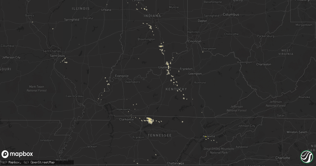
Hail Map in Kentucky on June 29, 2020
Get this storm
June 29 map
$229
one time, instant access
Download today. No call, no setup
Keep the $229
Bought the map and want the full workflow? Apply the entire $229 to a subscription within 7 days. None of it is wasted.
Every map, not just this one
This buys you this map. Subscription and you get every map we run, in the markets you choose from a few cities to whole states to nationwide. Plus real-time alerts the moment a storm fires.
Contact data
Name, contact info, occupancy, even credit band for addresses in the footprint. You go from where it hit to who to call.
Become the source they trust
Unlimited branding weather history reports on demand. You already have the documented answer ready for the property owner, and you are the one who showed up with it.
Property data and RoofTrace estimates
Pull up any address you have got, its value and the exact code rules for that jurisdiction, straight from One Click Code. Then RoofTrace estimates the squares, pitch, and roof value, priced the way you price.
Storm reports in Kentucky
Kentucky
| Date | Description |
|---|---|
| 06/29/20206:37 PM CDT | Trees down on rough ridge road and on dry fork ridge. Time estimated from radar data. |
| 06/29/20206:30 PM CDT | Multiple trees down in the bradfordsville area. |
| 06/29/20206:25 PM CDT | Multiple trees reported down in and near williamsburg. One tree fell on a transformer causing it to catch on fire. |
| 06/29/20206:02 PM CDT | Numerous trees down on ky 206 about 1 mile off of ky 70. Time estimated based on radar. |
| 06/29/20205:40 PM CDT | Tree down on woodrum ridge about 2 miles from hustonville st. Time estimated from radar. |
| 06/29/20204:05 PM CDT | Three trees have been reportedly blown down along highland lick road. |
| 06/29/20203:40 PM CDT | A tree was blown down along beechland road. |
| 06/29/20202:56 AM CDT | At 756 PM EDT, severe thunderstorms were located along a line extending from near Lebanon to 12 miles northwest of Liberty, moving south at 5 mph. HAZARD...60 mph wind gusts and nickel size hail. SOURCE...Radar indicated. IMPACT...Expect damage to roofs, siding, and trees. Locations impacted include... Campbellsville, Lebanon, Bradfordsville, Taylor County Airport, Bass, Spurlington, Belltown, Jessietown, Arista and Saloma. |
| 06/29/20202:29 AM CDT | At 728 PM EDT, severe thunderstorms were located along a line extending from 7 miles east of Lebanon to 12 miles north of Liberty, moving east at 10 mph. HAZARD...60 mph wind gusts and nickel size hail. SOURCE...Radar indicated. IMPACT...Expect damage to roofs, siding, and trees. Locations impacted include... Bradfordsville, Peytons Store, Brumfield, Parksville, Forkland, Jacktown, Merrimac, Aliceton, Mitchellsburg and Ellisburg. |
| 06/29/20202:05 AM CDT | At 705 PM EDT, a severe thunderstorm was located 13 miles northwest of Liberty, moving east at 10 mph. HAZARD...60 mph wind gusts and quarter size hail. SOURCE...Radar indicated. IMPACT...Hail damage to vehicles is expected. Expect wind damage to roofs, siding, and trees. Locations impacted include... Bradfordsville, Peytons Store, Brumfield, Parksville, Forkland, Jacktown, Aliceton, Mitchellsburg, Ellisburg and Gravel Switch. |
| 06/29/20201:37 AM CDT | At 637 PM EDT, a severe thunderstorm was located over Liberty, and is nearly stationary. HAZARD...60 mph wind gusts and quarter size hail. SOURCE...Radar indicated. IMPACT...Hail damage to vehicles is expected. Expect wind damage to roofs, siding, and trees. Locations impacted include... Liberty, Lanhamtown and Beech Bottom. |
| 06/29/20201:32 AM CDT | At 632 PM EDT, a severe thunderstorm was located 7 miles northwest of Springfield, moving east at 5 mph. HAZARD...60 mph wind gusts and penny size hail. SOURCE...Radar indicated. IMPACT...Expect damage to roofs, siding, and trees. Locations impacted include... Fredericktown, Hardesty, Cisselville, Booker, Bearwallow, Valley Hill, Botland, Mooresville, Polin and Croakes. |
| 06/28/202011:25 PM CDT | Several reports of trees downed in the foster area. Time estimated by radar. |
| 06/28/202010:27 PM CDT | At 326 PM CDT, a severe thunderstorm was located 9 miles south of Dunmor, moving southeast at 15 mph. HAZARD...60 mph wind gusts and penny size hail. SOURCE...Radar indicated. IMPACT...Expect damage to roofs, siding, and trees. Locations impacted include... Russellville, Anderson, Lewisburg, Justice, Insco, Gordonsville, Spa, Epleys, Wolf Lick and Everett. |
| 06/28/20207:26 PM CDT | Tree down on potts road. Times estimated from radar. |
| 06/28/20207:22 PM CDT | Trees down in the 7100 block of river road as well as near the intersection of the snyder and i-71. Time estimated from radar. |
All States Impacted by Hail Map on June 29, 2020
Cities Impacted by Hail Map on June 29, 2020
- Meadow, SD
- Dupree, SD
- Caputa, SD
- New Underwood, SD
- Albany, TX
- Dundee, IL
- New Haven, IL
- Ridgway, IL
- New Paltz, NY
- Alva, WY
- Seymour, IN
- Comstock, TX
- Belle Fourche, SD
- Beulah, WY
- Saint Onge, SD
- Spearfish, SD
- Ozona, TX
- Bison, SD
- Gallatin, TN
- Bethpage, TN
- Portland, TN
- Castalian Springs, TN
- Oshkosh, WI
- Winneconne, WI
- Glendive, MT
- Sundance, WY
- Raleigh, ND
- Watauga, SD
- New Leipzig, ND
- Shields, ND
- Morristown, SD
- Selfridge, ND
- Carson, ND
- Jacksonville, VT
- Colrain, MA
- Union Grove, WI
- Kenosha, WI
- Lueders, TX
- Stamford, TX
- Avoca, TX
- Plentywood, MT
- Clarksville, TN
- Deadwood, SD
- Nemo, SD
- Old Lyme, CT
- Montgomery, NY
- Walden, NY
- Union Center, SD
- Ovalo, TX
- Tuscola, TX
- Williamsburg, KY
- Newell, SD
- Madison, WI
- Killdeer, ND
- Fairfield, ND
- Watford City, ND
- Grassy Butte, ND
- Arnegard, ND
- Cartwright, ND
- Highland, NY
- Tillson, NY
- Ulster Park, NY
- Brooklyn, NY
- Outlook, MT
- Wibaux, MT
- Johnson Creek, WI
- Watertown, WI
- Granville, MA
- Sandisfield, MA
- Waddy, KY
- Shelbyville, KY
- Plaza, ND
- Lemmon, SD
- Belleville, WI
- New Glarus, WI
- Keene, ND
- Monon, IN
- Rensselaer, IN
- Birmingham, AL
- Norton, TX
- Winters, TX
- Bronte, TX
- Whitewood, SD
- Colebrook, CT
- Winsted, CT
- Knoxville, TN
- Prospect, TN
- Prairie City, SD
- Faith, SD
- Wingate, TX
- Blackwell, TX
- Flasher, ND
- Vale, SD
- Sturgis, SD
- Port Orange, FL
- Edgerton, WI
- Janesville, WI
- Venus, FL
- Lake Placid, FL
- Moorcroft, WY
- Louisville, KY
- Charlemont, MA
- Ashfield, MA
- Hazel Green, AL
- Meridianville, AL
- Toney, AL
- Huntsville, AL
- New Market, AL
- Ohatchee, AL
- Brooklyn, WI
- Mott, ND
- Estill Springs, TN
- Hill City, SD
- Redgranite, WI
- Neshkoro, WI
- Colchester, CT
- Lebanon, CT
- Upton, WY
- East Lyme, CT
- Pelzer, SC
- Malvern, AR
- Donaldson, AR
- Kansasville, WI
- Mundelein, IL
- Lake Zurich, IL
- Dickinson, ND
- New England, ND
- Lead, SD
- Scottsburg, IN
- Wilmington, IL
- Channahon, IL
- Mud Butte, SD
- Niantic, CT
- Orient, NY
- Fort Payne, AL
- Mentone, AL
- Gibbon, MN
- Winthrop, MN
- Barrington, IL
- Palatine, IL
- Hoffman Estates, IL
- Richardton, ND
- Robert Lee, TX
- Elgin, IL
- Carpentersville, IL
- Manning, ND
- Easley, SC
- Piedmont, SC
- Pine Ridge, SD
- Greenville, WI
- Sheridan, AR
- Abilene, TX
- Beach, ND
- Medora, ND
- Belfield, ND
- Belleville, IL
- O'Fallon, IL
- Traskwood, AR
- Poyen, AR
- Hulett, WY
- Sopchoppy, FL
- Cliffside Park, NJ
- Fort Lee, NJ
- Englewood, NJ
- Breezy Point, NY
- Tenafly, NJ
- Edgewater, NJ
- Leonia, NJ
- Astoria, NY
- Palisades Park, NJ
- Englewood Cliffs, NJ
- New York, NY
- Long Island City, NY
- North Bergen, NJ
- Bergenfield, NJ
- Stoughton, WI
- Piedmont, SD
- Berlin, WI
- Pine River, WI
- Whitewater, WI
- Rockford, IL
- Eubank, KY
- Science Hill, KY
- Redstone, MT
- Tye, TX
- Dyess Afb, TX
- Crawfordsville, IN
- Middleton, WI
- Homestead, MT
- Osage, WY
- Newcastle, WY
- Clintondale, NY
- Modena, NY
- Timber Lake, SD
- Ellington, CT
- Holdingford, MN
- Albany, MN
- Grey Eagle, MN
- Bowlus, MN
- Burtrum, MN
- Upsala, MN
- Neillsville, WI
- Raymond, MT
- Barnhart, TX
- Reeder, ND
- Aladdin, WY
- Greenwood, IN
- Dunn Center, ND
- Rapid City, SD
- Black Hawk, SD
- Enning, SD
- Accord, NY
- Peotone, IL
- Union, IL
- Woodstock, IL
- Merkel, TX
- Wallkill, NY
- Adams, TN
- Rockford, TN
- Dyer, IN
- Crown Point, IN
- Cedar Lake, IN
- Saint John, IN
- Schererville, IN
- Gladstone, ND
- Taylor, ND
- Prospect, KY
- Charlestown, IN
- Jeffersonville, IN
- Valparaiso, IN
- Milton, KY
- Blanchardville, WI
- Freeburg, IL
- Mascoutah, IL
- Storrs Mansfield, CT
- Mansfield Center, CT
- Goshen, KY
- Crestwood, KY
- Verona, WI
- New Bedford, MA
- South Dartmouth, MA
- North Dartmouth, MA
- Elizabethtown, IL
- Capron, IL
- Poplar Grove, IL
- Hull, IL
- Bardstown, KY
- Liberty, KY
- Coventry, CT
- Pell City, AL
- Eight Mile, AL
- Saraland, AL
- Roselle, IL
- Schaumburg, IL
- Pine Bush, NY
- Regent, ND
- Eagle Bend, MN
- South Wayne, WI
- Argyle, WI
- Ferryville, WI
- Colfax, IN
- Darlington, IN
- Bradfordsville, KY
- Lawn, TX
- Wolcott, IN
- Whiteland, IN
- Franklin, IN
- North Port, FL
- Blue Mounds, WI
- Black Earth, WI
- Monroe, WI
- Albany, WI
- Monticello, WI
- Mulberry Grove, IL
- Barneveld, WI
- Mattapoisett, MA
- Fairhaven, MA
- Acushnet, MA
- New Town, ND
- Richmond, IL
- Twin Lakes, WI
- Spring Grove, IL
- Ringwood, IL
- Mchenry, IL
- Rosendale, NY
- Gardiner, NY
- Newburgh, NY
- Marlboro, NY
- Cottontown, TN
- Sullivan, WI
- Jefferson, WI
- Helenville, WI
- Collinsville, AL
- Cedar Bluff, AL
- Leesburg, AL
- Clyde, TX
- Chattanooga, TN
- Donnybrook, ND
- Shepherdsville, KY
- Rock Spring, GA
- La Fayette, GA
- Mandaree, ND
- Lefor, ND
- Tunnel Hill, GA
- Ringgold, GA
- Mount Horeb, WI
- Cross Plains, WI
- Lake Crystal, MN
- Burlington, WI
- Francesville, IN
- Lebanon, IN
- Butte Des Morts, WI
- Bowling Green, FL
- Bartow, FL
- Fort Meade, FL
- Swanville, MN
- Little Falls, MN
- Lodgepole, SD
- Sharon, WI
- Bourbonnais, IL
- Hettinger, ND
- Rowe, MA
- Eagle, WI
- Belvidere, IL
- Caledonia, IL
- Bethelridge, KY
- Belton, SC
- Olivebridge, NY
- Loogootee, IN
- Gary, IN
- Hebron, IN
- Lowell, IN
- Pleasant Shade, TN
- Dixon Springs, TN
- Lafayette, TN
- Devils Tower, WY
- Marengo, IL
- Mertzon, TX
- Mount Washington, KY
- Hampshire, IL
- Fulda, MN
- Simpsonville, SC
- Fountain Inn, SC
- Falls Village, CT
- Frankfort, IN
- Crothersville, IN
- Omro, WI
- Larsen, WI
- Lansing, IL
- Calumet City, IL
- Hammond, IN
- Oregon, WI
- Austin, IN
- Bristol, WI
- Rockton, IL
- Stone Ridge, NY
- Louisville, TN
- Jamestown, TN
- Minooka, IL
- Marshfield, WI
- Monee, IL
- Braidwood, IL
- Coal City, IL
- Morris, IL
- Manhattan, IL
- Bedford, KY
- Spring Green, WI
- Darlington, WI
- Mineral Point, WI
- Shullsburg, WI
- Edgefield, SC
- Johnston, SC
- Saluda, SC
- Ward, SC
- Browerville, MN
- Cedar Hill, TN
- Springfield, KY
- Hermosa, SD
- Hollandale, WI
- East Haddam, CT
- Evansville, WI
- Millstadt, IL
- Clanton, AL
- Jefferson, AR
- White Hall, AR
- Lansing, IA
- Lafayette, IN
- Fishers, IN
- Keldron, SD
- Lynchburg, OH
- Sardinia, OH
- Auburndale, FL
- Lake Alfred, FL
- Parsons, KS
- Fort Myers, FL
- Griffith, IN
- Crete, IL
- Gurley, AL
- Hot Springs National Park, AR
- Pulaski, TN
- Scottsboro, AL
- Black River Falls, WI
- Madelia, MN
- Hanska, MN
- Saint James, MN
- Pewaukee, WI
- Harvard, IL
- Kerhonkson, NY
- Altheimer, AR
- Attica, IN
- Williamsport, IN
- La Grange, KY
- Westport, KY
- Montello, WI
- Loretto, KY
- Winamac, IN
- Morgantown, IN
- Stevenson, AL
- Scipio, IN
- Lakeland, FL
- Clayton, IN
- Golconda, IL
- Pecatonica, IL
- Durand, IL
- Isabel, SD
- Halliday, ND
- Prattsville, AR
- Endeavor, WI
- Springfield, TN
- White House, TN
- Greenbrier, TN
- Labelle, FL
- Mukwonago, WI
- Mazon, IL
- Wilsonville, AL
- Beulah, ND
- Bloomingdale, IL
- Elk Grove Village, IL
- Medinah, IL
- Itasca, IL
- Coleman, TX
- Goldsboro, TX
- Grantsburg, WI
- Sturgis, KY
- Morganfield, KY
- Shawneetown, IL
- Buffalo Gap, TX
- Novice, TX
- Nolan, TX
- White Plains, KY
- Juda, WI
- Ware Shoals, SC
- Waterloo, SC
- Laurens, SC
- Dunnville, KY
- McLaughlin, SD
- Bartlett, IL
- Wayne, IL
- Saint Charles, IL
- South Elgin, IL
- Streamwood, IL
- Algonquin, IL
- Bethel, OH
- Williamsburg, OH
- Trenton, KY
- Kankakee, IL
- Thorntown, IN
- South Heart, ND
- Long Prairie, MN
- Hampton, KY
- Ragland, AL
- Sun Prairie, WI
- Arena, WI
- Chicago Heights, IL
- Glenwood, IL
- Burna, KY
- Liberty, SC
- New Berlin, WI
- Big Bend, WI
- Waukesha, WI
- McIntosh, SD
- Lance Creek, WY
- Monticello, GA
- Jackson, GA
- Waukegan, IL
- Zion, IL
- Westmoreland, TN
- Hartsville, TN
- Coatesville, IN
- Beloit, WI
- Lake Geneva, WI
- Deerfield, MA
- Romney, IN
- Lebanon, KY
- Greenwood, SC
- Hodges, SC
- Salem, WI
- Saint Louis, MO
- Red Boiling Springs, TN
- Alexandria, AL
- Bowling Green, MO
- Palmyra, WI
- East Troy, WI
- Pelham, AL
- Florence, AL
- Killen, AL
- Brooklyn, IN
- Mooresville, IN
- Martinsville, IN
- East Chicago, IN
- Norris City, IL
- Omaha, IL
- Lewisburg, KY
- Walland, TN
- Sherrill, AR
- Warrens, WI
- Amsterdam, NY
- Momence, IL
- Grant Park, IL
- Brookport, IL
- Stanley, ND
- Menlo, GA
- Highland, IN
- Roodhouse, IL
- Guthrie, KY
- Manteno, IL
- Stony Point, NY
- Southfields, NY
- Pomona, NY
- Ormond Beach, FL
- Genoa, IL
- Demotte, IN
- Bloomfield, KY
- South Beloit, IL
- Merrillan, WI
- Seymour, TN
- Nantucket, MA
- Foster, KY
- Taylorsville, KY
- Coxs Creek, KY
- Bertha, MN
- Humbird, WI
- Russellville, KY
- Lake Villa, IL
- Gurnee, IL
- Mulberry, TN
- Clinton, WI
- Salem, CT
- Rantoul, IL
- Wonder Lake, IL
- Hebron, IL
- Haskell, TX
- Waterford, WI
- Leeds, AL
- Henagar, AL
- Pigeon Forge, TN
- Sevierville, TN
- Fox Lake, IL
- Ingleside, IL
- Gilberts, IL
- Deerfield, WI
- Cambridge, WI
- Cottage Grove, WI
- Box Elder, SD
- Ross, ND
- Dodge, ND
- Summerville, GA
- Alexander, ND
- Greenfield, MA
- Easthampton, MA
- Northampton, MA
- South Hadley, MA
- Chicopee, MA
- Granby, MA
- Oakdale, CT
- Goshen, CT
- West Cornwall, CT


