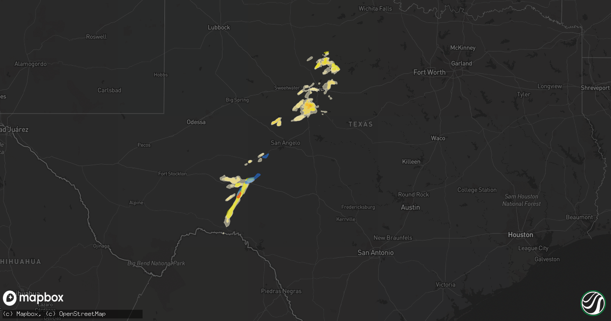
Hail Map in Texas on June 29, 2020
Get this storm
June 29 map
$229
one time, instant access
Download today. No call, no setup
Keep the $229
Bought the map and want the full workflow? Apply the entire $229 to a subscription within 7 days. None of it is wasted.
Every map, not just this one
This buys you this map. Subscription and you get every map we run, in the markets you choose from a few cities to whole states to nationwide. Plus real-time alerts the moment a storm fires.
Contact data
Name, contact info, occupancy, even credit band for addresses in the footprint. You go from where it hit to who to call.
Become the source they trust
Unlimited branding weather history reports on demand. You already have the documented answer ready for the property owner, and you are the one who showed up with it.
Property data and RoofTrace estimates
Pull up any address you have got, its value and the exact code rules for that jurisdiction, straight from One Click Code. Then RoofTrace estimates the squares, pitch, and roof value, priced the way you price.
Storm reports in Texas
Texas
| Date | Description |
|---|---|
| 06/29/20206:55 PM CDT | A local report indicates 70 MPH wind near 1 N OZONA |
| 06/29/20205:03 PM CDT | A local report indicates 59 MPH wind near 3 N AVOCA |
| 06/29/20203:59 AM CDT | At 858 PM CDT, a cluster of severe thunderstorms was located near Norton, or 8 miles west of Winters, moving east at 30 mph. Other storms developing in northern Runnels County could also strengthen and become severe. Frequent and deadly lightning also accompany the storms. HAZARD...60 mph wind gusts and quarter size hail. SOURCE...Radar indicated. IMPACT...Hail damage to vehicles is expected. Expect wind damage to roofs, siding, and trees. This severe thunderstorms will be near... Hatchel around 910 PM CDT. Winters around 915 PM CDT. Crews around 935 PM CDT.Other locations impacted by this severe thunderstorm includePumphrey, Wilmeth and Lake Winters Lake. |
| 06/29/20203:13 AM CDT | At 812 PM CDT, a severe thunderstorm was located near Bradshaw, or 11 miles northeast of Winters, moving east-southeast at 15 mph. HAZARD...60 mph wind gusts and quarter size hail. SOURCE...Radar indicated. IMPACT...Hail damage to vehicles is expected. Expect wind damage to roofs, siding, and trees. This severe thunderstorm will be near... Crews around 850 PM CDT. Novice around 900 PM CDT.Other locations impacted by this severe thunderstorm includeGoldsboro and Ovalo. |
| 06/29/20202:39 AM CDT | At 738 PM CDT, a severe thunderstorm was located near Bradshaw, or 14 miles north of Winters, moving east at 15 mph. HAZARD...60 mph wind gusts and quarter size hail. SOURCE...Radar indicated. IMPACT...Hail damage to vehicles is expected. Expect wind damage to roofs, siding, and trees. This severe thunderstorm will be near... Tuscola around 755 PM CDT. Lawn around 810 PM CDT.Other locations impacted by this severe thunderstorm include LakeAbilene, Ovalo and Camp Tonkawa. |
| 06/29/20202:23 AM CDT | At 721 PM CDT, a severe thunderstorm was located near Mertzon, moving northeast at 30 mph. HAZARD...60 mph wind gusts and penny size hail. SOURCE...Radar indicated. IMPACT...Expect damage to roofs, siding, and trees. This severe thunderstorm will be near... Mertzon and Sherwood around 730 PM CDT. Arden around 750 PM CDT. Carlsbad around 800 PM CDT.Other locations impacted by this severe thunderstorm include Us-67 Near The Irion-Tom Green County Line. |
| 06/29/20202:19 AM CDT | At 718 PM CDT, a severe thunderstorm was located near Albany, moving east at 15 mph. HAZARD...60 mph wind gusts and quarter size hail. SOURCE...Radar indicated. IMPACT...Hail damage to vehicles is expected. Expect wind damage to roofs, siding, and trees. This severe thunderstorm will remain over mainly rural areas of northeastern Shackelford County, including the following locations... Us-180 Near The Shackelford-Stephens County Line. |
| 06/29/20202:00 AM CDT | At 659 PM CDT, a severe thunderstorm was located 10 miles south of Albany, moving northeast at 20 mph. HAZARD...60 mph wind gusts and half dollar size hail. SOURCE...Radar indicated. IMPACT...Hail damage to vehicles is expected. Expect wind damage to roofs, siding, and trees. This severe thunderstorm will be near... Albany around 735 PM CDT. Ibex around 745 PM CDT.Other locations impacted by this severe thunderstorm include MccartyLake. |
| 06/29/20201:45 AM CDT | At 643 PM CDT, a severe thunderstorm was located near Ozona, moving northeast at 30 mph. HAZARD...Ping pong ball size hail and 60 mph wind gusts. SOURCE...Radar indicated. IMPACT...People and animals outdoors will be injured. Expect hail damage to roofs, siding, windows, and vehicles. Expect wind damage to roofs, siding, and trees. This severe thunderstorm will remain over mainly rural areas of northwestern Schleicher and Crockett Counties, including the following locations... The Intersection Of Us 190 And Highway 163, Us-190 Near The Crockett-Sutton County Line, Ft Lancaster, The Intersection Of Highway 163 And Ranch Road 1973, The Intersection Of I-10 And Highway 405 and The Intersection Of I-10 And Highway 290.This includes Interstate 10 between Mile Markers 329 and 378. |
| 06/29/20201:34 AM CDT | At 634 PM CDT, a severe thunderstorm was located 9 miles east of Hamby, or 9 miles north of Clyde, moving northeast at 15 mph. HAZARD...60 mph wind gusts and quarter size hail. SOURCE...Radar indicated. IMPACT...Hail damage to vehicles is expected. Expect wind damage to roofs, siding, and trees. This severe thunderstorm will remain over mainly rural areas of north central Callahan and southern Shackelford Counties, including the following locations... Mccarty Lake and Us-283 Near The Callahan-Shackelford County Line. |
| 06/29/20201:31 AM CDT | At 631 PM CDT, a severe thunderstorm was located near Irby, or 12 miles east of Haskell, moving northeast at 20 mph. HAZARD...60 mph wind gusts and quarter size hail. SOURCE...Radar indicated. IMPACT...Hail damage to vehicles is expected. Expect wind damage to roofs, siding, and trees. This severe thunderstorm will be near... Irby around 645 PM CDT.Other locations impacted by this severe thunderstorm include TheIntersection Of Us-380 And Highway 222. |
| 06/29/20201:16 AM CDT | At 616 PM CDT, a cluster of severe thunderstorms was located 12 miles northeast of Lueders, or 15 miles northwest of Albany, moving east at 20 mph. HAZARD...60 mph wind gusts and quarter size hail. SOURCE...Radar indicated. IMPACT...Hail damage to vehicles is expected. Expect wind damage to roofs, siding, and trees. This severe thunderstorm will be near... Fort Griffin around 715 PM CDT. |
| 06/29/202012:57 AM CDT | At 555 PM CDT, a severe thunderstorm was in far southern Crockett County, located 13 miles north of Pandale, or 27 miles northwest of Juno, and moving northeast at 35 mph. HAZARD...60 mph wind gusts and quarter size hail. SOURCE...Radar indicated. IMPACT...Hail damage to vehicles is expected. Expect wind damage to roofs, siding, and trees. This severe thunderstorm will be near... Ozona around 640 PM CDT.Other locations impacted by this severe thunderstorm include TheIntersection Of Ranch Road 2083 And Highway 405 and The IntersectionOf Highway 163 And Ranch Road 1973.This includes Interstate 10 between Mile Markers 353 and 376. |
| 06/29/202012:43 AM CDT | At 543 PM CDT, a severe thunderstorm was located 8 miles southeast of Lake Stamford Marina, or 14 miles east of Stamford, moving northeast at 25 mph. HAZARD...60 mph wind gusts and quarter size hail. SOURCE...Radar indicated. IMPACT...Hail damage to vehicles is expected. Expect wind damage to roofs, siding, and trees. This severe thunderstorm will remain over mainly rural areas of southeastern Haskell, northwestern Shackelford and southwestern Throckmorton Counties. |
| 06/29/202012:24 AM CDT | At 523 PM CDT, a severe thunderstorm was located 7 miles southwest of Pandale, or 21 miles north of Langtry, moving north at 35 mph. HAZARD...60 mph wind gusts and quarter size hail. SOURCE...Radar indicated. IMPACT...Hail damage to vehicles is expected. Expect wind damage to roofs, siding, and trees. Locations impacted include... Pandale. |
| 06/29/202012:05 AM CDT | At 504 PM CDT, a severe thunderstorm was located over Avoca, or 7 miles southeast of Stamford, moving northeast at 35 mph. HAZARD...60 mph wind gusts and half dollar size hail. SOURCE...Radar indicated. IMPACT...Hail damage to vehicles is expected. Expect wind damage to roofs, siding, and trees. This severe thunderstorm will be near... Lake Stamford Marina around 520 PM CDT. |
| 06/28/20209:55 PM CDT | The novice volunteer fire department reported extensive tree damage across town along with a utility pole blown down. |
| 06/28/20209:10 PM CDT | Corrects previous tstm wnd dmg report from 2 w winters. Six to seven large trees snapped and uprooted by winters country club. Also... Roof damage occurred there. |
All States Impacted by Hail Map on June 29, 2020
Cities Impacted by Hail Map on June 29, 2020
- Meadow, SD
- Dupree, SD
- Caputa, SD
- New Underwood, SD
- Albany, TX
- Dundee, IL
- New Haven, IL
- Ridgway, IL
- New Paltz, NY
- Alva, WY
- Seymour, IN
- Comstock, TX
- Belle Fourche, SD
- Beulah, WY
- Saint Onge, SD
- Spearfish, SD
- Ozona, TX
- Bison, SD
- Gallatin, TN
- Bethpage, TN
- Portland, TN
- Castalian Springs, TN
- Oshkosh, WI
- Winneconne, WI
- Glendive, MT
- Sundance, WY
- Raleigh, ND
- Watauga, SD
- New Leipzig, ND
- Shields, ND
- Morristown, SD
- Selfridge, ND
- Carson, ND
- Jacksonville, VT
- Colrain, MA
- Union Grove, WI
- Kenosha, WI
- Lueders, TX
- Stamford, TX
- Avoca, TX
- Plentywood, MT
- Clarksville, TN
- Deadwood, SD
- Nemo, SD
- Old Lyme, CT
- Montgomery, NY
- Walden, NY
- Union Center, SD
- Ovalo, TX
- Tuscola, TX
- Williamsburg, KY
- Newell, SD
- Madison, WI
- Killdeer, ND
- Fairfield, ND
- Watford City, ND
- Grassy Butte, ND
- Arnegard, ND
- Cartwright, ND
- Highland, NY
- Tillson, NY
- Ulster Park, NY
- Brooklyn, NY
- Outlook, MT
- Wibaux, MT
- Johnson Creek, WI
- Watertown, WI
- Granville, MA
- Sandisfield, MA
- Waddy, KY
- Shelbyville, KY
- Plaza, ND
- Lemmon, SD
- Belleville, WI
- New Glarus, WI
- Keene, ND
- Monon, IN
- Rensselaer, IN
- Birmingham, AL
- Norton, TX
- Winters, TX
- Bronte, TX
- Whitewood, SD
- Colebrook, CT
- Winsted, CT
- Knoxville, TN
- Prospect, TN
- Prairie City, SD
- Faith, SD
- Wingate, TX
- Blackwell, TX
- Flasher, ND
- Vale, SD
- Sturgis, SD
- Port Orange, FL
- Edgerton, WI
- Janesville, WI
- Venus, FL
- Lake Placid, FL
- Moorcroft, WY
- Louisville, KY
- Charlemont, MA
- Ashfield, MA
- Hazel Green, AL
- Meridianville, AL
- Toney, AL
- Huntsville, AL
- New Market, AL
- Ohatchee, AL
- Brooklyn, WI
- Mott, ND
- Estill Springs, TN
- Hill City, SD
- Redgranite, WI
- Neshkoro, WI
- Colchester, CT
- Lebanon, CT
- Upton, WY
- East Lyme, CT
- Pelzer, SC
- Malvern, AR
- Donaldson, AR
- Kansasville, WI
- Mundelein, IL
- Lake Zurich, IL
- Dickinson, ND
- New England, ND
- Lead, SD
- Scottsburg, IN
- Wilmington, IL
- Channahon, IL
- Mud Butte, SD
- Niantic, CT
- Orient, NY
- Fort Payne, AL
- Mentone, AL
- Gibbon, MN
- Winthrop, MN
- Barrington, IL
- Palatine, IL
- Hoffman Estates, IL
- Richardton, ND
- Robert Lee, TX
- Elgin, IL
- Carpentersville, IL
- Manning, ND
- Easley, SC
- Piedmont, SC
- Pine Ridge, SD
- Greenville, WI
- Sheridan, AR
- Abilene, TX
- Beach, ND
- Medora, ND
- Belfield, ND
- Belleville, IL
- O'Fallon, IL
- Traskwood, AR
- Poyen, AR
- Hulett, WY
- Sopchoppy, FL
- Cliffside Park, NJ
- Fort Lee, NJ
- Englewood, NJ
- Breezy Point, NY
- Tenafly, NJ
- Edgewater, NJ
- Leonia, NJ
- Astoria, NY
- Palisades Park, NJ
- Englewood Cliffs, NJ
- New York, NY
- Long Island City, NY
- North Bergen, NJ
- Bergenfield, NJ
- Stoughton, WI
- Piedmont, SD
- Berlin, WI
- Pine River, WI
- Whitewater, WI
- Rockford, IL
- Eubank, KY
- Science Hill, KY
- Redstone, MT
- Tye, TX
- Dyess Afb, TX
- Crawfordsville, IN
- Middleton, WI
- Homestead, MT
- Osage, WY
- Newcastle, WY
- Clintondale, NY
- Modena, NY
- Timber Lake, SD
- Ellington, CT
- Holdingford, MN
- Albany, MN
- Grey Eagle, MN
- Bowlus, MN
- Burtrum, MN
- Upsala, MN
- Neillsville, WI
- Raymond, MT
- Barnhart, TX
- Reeder, ND
- Aladdin, WY
- Greenwood, IN
- Dunn Center, ND
- Rapid City, SD
- Black Hawk, SD
- Enning, SD
- Accord, NY
- Peotone, IL
- Union, IL
- Woodstock, IL
- Merkel, TX
- Wallkill, NY
- Adams, TN
- Rockford, TN
- Dyer, IN
- Crown Point, IN
- Cedar Lake, IN
- Saint John, IN
- Schererville, IN
- Gladstone, ND
- Taylor, ND
- Prospect, KY
- Charlestown, IN
- Jeffersonville, IN
- Valparaiso, IN
- Milton, KY
- Blanchardville, WI
- Freeburg, IL
- Mascoutah, IL
- Storrs Mansfield, CT
- Mansfield Center, CT
- Goshen, KY
- Crestwood, KY
- Verona, WI
- New Bedford, MA
- South Dartmouth, MA
- North Dartmouth, MA
- Elizabethtown, IL
- Capron, IL
- Poplar Grove, IL
- Hull, IL
- Bardstown, KY
- Liberty, KY
- Coventry, CT
- Pell City, AL
- Eight Mile, AL
- Saraland, AL
- Roselle, IL
- Schaumburg, IL
- Pine Bush, NY
- Regent, ND
- Eagle Bend, MN
- South Wayne, WI
- Argyle, WI
- Ferryville, WI
- Colfax, IN
- Darlington, IN
- Bradfordsville, KY
- Lawn, TX
- Wolcott, IN
- Whiteland, IN
- Franklin, IN
- North Port, FL
- Blue Mounds, WI
- Black Earth, WI
- Monroe, WI
- Albany, WI
- Monticello, WI
- Mulberry Grove, IL
- Barneveld, WI
- Mattapoisett, MA
- Fairhaven, MA
- Acushnet, MA
- New Town, ND
- Richmond, IL
- Twin Lakes, WI
- Spring Grove, IL
- Ringwood, IL
- Mchenry, IL
- Rosendale, NY
- Gardiner, NY
- Newburgh, NY
- Marlboro, NY
- Cottontown, TN
- Sullivan, WI
- Jefferson, WI
- Helenville, WI
- Collinsville, AL
- Cedar Bluff, AL
- Leesburg, AL
- Clyde, TX
- Chattanooga, TN
- Donnybrook, ND
- Shepherdsville, KY
- Rock Spring, GA
- La Fayette, GA
- Mandaree, ND
- Lefor, ND
- Tunnel Hill, GA
- Ringgold, GA
- Mount Horeb, WI
- Cross Plains, WI
- Lake Crystal, MN
- Burlington, WI
- Francesville, IN
- Lebanon, IN
- Butte Des Morts, WI
- Bowling Green, FL
- Bartow, FL
- Fort Meade, FL
- Swanville, MN
- Little Falls, MN
- Lodgepole, SD
- Sharon, WI
- Bourbonnais, IL
- Hettinger, ND
- Rowe, MA
- Eagle, WI
- Belvidere, IL
- Caledonia, IL
- Bethelridge, KY
- Belton, SC
- Olivebridge, NY
- Loogootee, IN
- Gary, IN
- Hebron, IN
- Lowell, IN
- Pleasant Shade, TN
- Dixon Springs, TN
- Lafayette, TN
- Devils Tower, WY
- Marengo, IL
- Mertzon, TX
- Mount Washington, KY
- Hampshire, IL
- Fulda, MN
- Simpsonville, SC
- Fountain Inn, SC
- Falls Village, CT
- Frankfort, IN
- Crothersville, IN
- Omro, WI
- Larsen, WI
- Lansing, IL
- Calumet City, IL
- Hammond, IN
- Oregon, WI
- Austin, IN
- Bristol, WI
- Rockton, IL
- Stone Ridge, NY
- Louisville, TN
- Jamestown, TN
- Minooka, IL
- Marshfield, WI
- Monee, IL
- Braidwood, IL
- Coal City, IL
- Morris, IL
- Manhattan, IL
- Bedford, KY
- Spring Green, WI
- Darlington, WI
- Mineral Point, WI
- Shullsburg, WI
- Edgefield, SC
- Johnston, SC
- Saluda, SC
- Ward, SC
- Browerville, MN
- Cedar Hill, TN
- Springfield, KY
- Hermosa, SD
- Hollandale, WI
- East Haddam, CT
- Evansville, WI
- Millstadt, IL
- Clanton, AL
- Jefferson, AR
- White Hall, AR
- Lansing, IA
- Lafayette, IN
- Fishers, IN
- Keldron, SD
- Lynchburg, OH
- Sardinia, OH
- Auburndale, FL
- Lake Alfred, FL
- Parsons, KS
- Fort Myers, FL
- Griffith, IN
- Crete, IL
- Gurley, AL
- Hot Springs National Park, AR
- Pulaski, TN
- Scottsboro, AL
- Black River Falls, WI
- Madelia, MN
- Hanska, MN
- Saint James, MN
- Pewaukee, WI
- Harvard, IL
- Kerhonkson, NY
- Altheimer, AR
- Attica, IN
- Williamsport, IN
- La Grange, KY
- Westport, KY
- Montello, WI
- Loretto, KY
- Winamac, IN
- Morgantown, IN
- Stevenson, AL
- Scipio, IN
- Lakeland, FL
- Clayton, IN
- Golconda, IL
- Pecatonica, IL
- Durand, IL
- Isabel, SD
- Halliday, ND
- Prattsville, AR
- Endeavor, WI
- Springfield, TN
- White House, TN
- Greenbrier, TN
- Labelle, FL
- Mukwonago, WI
- Mazon, IL
- Wilsonville, AL
- Beulah, ND
- Bloomingdale, IL
- Elk Grove Village, IL
- Medinah, IL
- Itasca, IL
- Coleman, TX
- Goldsboro, TX
- Grantsburg, WI
- Sturgis, KY
- Morganfield, KY
- Shawneetown, IL
- Buffalo Gap, TX
- Novice, TX
- Nolan, TX
- White Plains, KY
- Juda, WI
- Ware Shoals, SC
- Waterloo, SC
- Laurens, SC
- Dunnville, KY
- McLaughlin, SD
- Bartlett, IL
- Wayne, IL
- Saint Charles, IL
- South Elgin, IL
- Streamwood, IL
- Algonquin, IL
- Bethel, OH
- Williamsburg, OH
- Trenton, KY
- Kankakee, IL
- Thorntown, IN
- South Heart, ND
- Long Prairie, MN
- Hampton, KY
- Ragland, AL
- Sun Prairie, WI
- Arena, WI
- Chicago Heights, IL
- Glenwood, IL
- Burna, KY
- Liberty, SC
- New Berlin, WI
- Big Bend, WI
- Waukesha, WI
- McIntosh, SD
- Lance Creek, WY
- Monticello, GA
- Jackson, GA
- Waukegan, IL
- Zion, IL
- Westmoreland, TN
- Hartsville, TN
- Coatesville, IN
- Beloit, WI
- Lake Geneva, WI
- Deerfield, MA
- Romney, IN
- Lebanon, KY
- Greenwood, SC
- Hodges, SC
- Salem, WI
- Saint Louis, MO
- Red Boiling Springs, TN
- Alexandria, AL
- Bowling Green, MO
- Palmyra, WI
- East Troy, WI
- Pelham, AL
- Florence, AL
- Killen, AL
- Brooklyn, IN
- Mooresville, IN
- Martinsville, IN
- East Chicago, IN
- Norris City, IL
- Omaha, IL
- Lewisburg, KY
- Walland, TN
- Sherrill, AR
- Warrens, WI
- Amsterdam, NY
- Momence, IL
- Grant Park, IL
- Brookport, IL
- Stanley, ND
- Menlo, GA
- Highland, IN
- Roodhouse, IL
- Guthrie, KY
- Manteno, IL
- Stony Point, NY
- Southfields, NY
- Pomona, NY
- Ormond Beach, FL
- Genoa, IL
- Demotte, IN
- Bloomfield, KY
- South Beloit, IL
- Merrillan, WI
- Seymour, TN
- Nantucket, MA
- Foster, KY
- Taylorsville, KY
- Coxs Creek, KY
- Bertha, MN
- Humbird, WI
- Russellville, KY
- Lake Villa, IL
- Gurnee, IL
- Mulberry, TN
- Clinton, WI
- Salem, CT
- Rantoul, IL
- Wonder Lake, IL
- Hebron, IL
- Haskell, TX
- Waterford, WI
- Leeds, AL
- Henagar, AL
- Pigeon Forge, TN
- Sevierville, TN
- Fox Lake, IL
- Ingleside, IL
- Gilberts, IL
- Deerfield, WI
- Cambridge, WI
- Cottage Grove, WI
- Box Elder, SD
- Ross, ND
- Dodge, ND
- Summerville, GA
- Alexander, ND
- Greenfield, MA
- Easthampton, MA
- Northampton, MA
- South Hadley, MA
- Chicopee, MA
- Granby, MA
- Oakdale, CT
- Goshen, CT
- West Cornwall, CT


