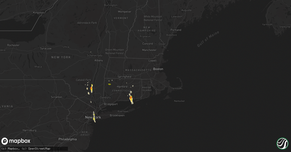
Hail Map in Connecticut on June 29, 2020
Get this storm
June 29 map
$229
one time, instant access
Download today. No call, no setup
Keep the $229
Bought the map and want the full workflow? Apply the entire $229 to a subscription within 7 days. None of it is wasted.
Every map, not just this one
This buys you this map. Subscription and you get every map we run, in the markets you choose from a few cities to whole states to nationwide. Plus real-time alerts the moment a storm fires.
Contact data
Name, contact info, occupancy, even credit band for addresses in the footprint. You go from where it hit to who to call.
Become the source they trust
Unlimited branding weather history reports on demand. You already have the documented answer ready for the property owner, and you are the one who showed up with it.
Property data and RoofTrace estimates
Pull up any address you have got, its value and the exact code rules for that jurisdiction, straight from One Click Code. Then RoofTrace estimates the squares, pitch, and roof value, priced the way you price.
Storm reports in Connecticut
Connecticut
| Date | Description |
|---|---|
| 06/29/20203:15 PM CDT | One inch hail reported on halls hill road |
| 06/29/20203:05 PM CDT | One inch hail reported in sound view section of old lyme |
| 06/29/20203:02 PM CDT | Half dollar sized hail reported |
| 06/29/20203:00 PM CDT | Golf ball sized hail reported. Time estimated by radar. |
| 06/29/20203:00 PM CDT | Hail one inch in diameter reported |
| 06/29/20202:56 PM CDT | Trees and wires down blocking road on route 14 |
| 06/29/20202:50 PM CDT | Golf ball sized hail reported near sterling hill road. Time estimated by radar. |
| 06/29/20202:44 PM CDT | Trees and wires down on sugar hill rd |
| 06/29/20202:12 PM CDT | Hunter lane |
| 06/28/202011:06 PM CDT | At 406 PM EDT, a severe thunderstorm was located over Willimantic, or near Windham, moving southeast at 30 mph. HAZARD...60 mph wind gusts and penny size hail. SOURCE...Radar indicated. IMPACT...Expect damage to trees and power lines. This severe thunderstorm will be near... Lebanon around 410 PM EDT. Colchester around 415 PM EDT. Sprague around 425 PM EDT. Norwich and Bozrah around 430 PM EDT. Salem around 435 PM EDT. Gales Ferry around 440 PM EDT. Waterford and Ledyard Center around 445 PM EDT. |
| 06/28/202010:42 PM CDT | At 342 PM EDT, a severe thunderstorm was located over North Lyme, or near Salem, moving east at 5 mph. HAZARD...Quarter size hail. SOURCE...Radar indicated. IMPACT...Minor damage to vehicles is possible. This severe thunderstorm will be near... Salem around 420 PM EDT. East Lyme around 445 PM EDT. |
| 06/28/202010:38 PM CDT | At 338 PM EDT, a severe thunderstorm was located over Chaplin, or near Mansfield, moving south at 15 mph. HAZARD...60 mph wind gusts and quarter size hail. SOURCE...Radar indicated. IMPACT...Expect wind damage to trees and power lines. Minor hail damage to vehicles is possible. This severe thunderstorm will be near... Hampton around 345 PM EDT. Windham around 350 PM EDT. Willimantic around 355 PM EDT. Scotland around 425 PM EDT. |
| 06/28/202010:36 PM CDT | At 335 PM EDT, a severe thunderstorm was located over East Lyme, or near New London, moving southeast at 20 mph. HAZARD...Quarter size hail. SOURCE...Radar indicated. IMPACT...Minor damage to vehicles is possible. This severe thunderstorm will be near... New London around 350 PM EDT. Waterford around 355 PM EDT. Mystic around 405 PM EDT. |
| 06/28/202010:08 PM CDT | At 307 PM EDT, a severe thunderstorm was located over Naugatuck, moving southeast at 15 mph. HAZARD...Quarter size hail. SOURCE...Radar indicated. IMPACT...Minor damage to vehicles is possible. This severe thunderstorm will be near... Prospect and Beacon Falls around 315 PM EDT. Monroe around 320 PM EDT. Woodbridge and Bethany around 335 PM EDT. Seymour and Derby around 340 PM EDT. New Haven around 355 PM EDT. Milford and Shelton around 400 PM EDT. |
| 06/28/20209:56 PM CDT | At 256 PM EDT, a severe thunderstorm was located New London, moving southeast at 15 mph. HAZARD...60 mph wind gusts and quarter size hail. SOURCE...Radar indicated. IMPACT...Expect wind damage to trees and power lines. Minor hail damage to vehicles is possible. This severe thunderstorm will be near... Westerly around 300 PM EDT. Charlestown around 335 PM EDT. |
| 06/28/20209:50 PM CDT | At 250 PM EDT, a severe thunderstorm was located near Litchfield, or near Torrington, moving south at 25 mph. HAZARD...60 mph wind gusts and quarter size hail. SOURCE...Radar indicated. IMPACT...Hail damage to vehicles is expected. Expect wind damage to roofs, siding, and trees. Locations impacted include... Torrington, Thomaston, Litchfield, Northwest Harwinton, Oakville, Woodbury Center, Cornwall Bridge, New Preston, Watertown, Plymouth, Woodbury, Bethlehem, Washington, Goshen, Morris, Roxbury, Warren, Cornwall, Bantam and West Torrington. |
| 06/28/20209:49 PM CDT | At 249 PM EDT, a severe thunderstorm was located over Norwich--New London, or 7 miles northeast of Mystic, moving southeast at 5 mph. HAZARD...Quarter size hail. SOURCE...Radar indicated. IMPACT...Minor damage to vehicles is possible. This severe thunderstorm will remain over southeastern New London County. |
All States Impacted by Hail Map on June 29, 2020
Cities Impacted by Hail Map on June 29, 2020
- Meadow, SD
- Dupree, SD
- Caputa, SD
- New Underwood, SD
- Albany, TX
- Dundee, IL
- New Haven, IL
- Ridgway, IL
- New Paltz, NY
- Alva, WY
- Seymour, IN
- Comstock, TX
- Belle Fourche, SD
- Beulah, WY
- Saint Onge, SD
- Spearfish, SD
- Ozona, TX
- Bison, SD
- Gallatin, TN
- Bethpage, TN
- Portland, TN
- Castalian Springs, TN
- Oshkosh, WI
- Winneconne, WI
- Glendive, MT
- Sundance, WY
- Raleigh, ND
- Watauga, SD
- New Leipzig, ND
- Shields, ND
- Morristown, SD
- Selfridge, ND
- Carson, ND
- Jacksonville, VT
- Colrain, MA
- Union Grove, WI
- Kenosha, WI
- Lueders, TX
- Stamford, TX
- Avoca, TX
- Plentywood, MT
- Clarksville, TN
- Deadwood, SD
- Nemo, SD
- Old Lyme, CT
- Montgomery, NY
- Walden, NY
- Union Center, SD
- Ovalo, TX
- Tuscola, TX
- Williamsburg, KY
- Newell, SD
- Madison, WI
- Killdeer, ND
- Fairfield, ND
- Watford City, ND
- Grassy Butte, ND
- Arnegard, ND
- Cartwright, ND
- Highland, NY
- Tillson, NY
- Ulster Park, NY
- Brooklyn, NY
- Outlook, MT
- Wibaux, MT
- Johnson Creek, WI
- Watertown, WI
- Granville, MA
- Sandisfield, MA
- Waddy, KY
- Shelbyville, KY
- Plaza, ND
- Lemmon, SD
- Belleville, WI
- New Glarus, WI
- Keene, ND
- Monon, IN
- Rensselaer, IN
- Birmingham, AL
- Norton, TX
- Winters, TX
- Bronte, TX
- Whitewood, SD
- Colebrook, CT
- Winsted, CT
- Knoxville, TN
- Prospect, TN
- Prairie City, SD
- Faith, SD
- Wingate, TX
- Blackwell, TX
- Flasher, ND
- Vale, SD
- Sturgis, SD
- Port Orange, FL
- Edgerton, WI
- Janesville, WI
- Venus, FL
- Lake Placid, FL
- Moorcroft, WY
- Louisville, KY
- Charlemont, MA
- Ashfield, MA
- Hazel Green, AL
- Meridianville, AL
- Toney, AL
- Huntsville, AL
- New Market, AL
- Ohatchee, AL
- Brooklyn, WI
- Mott, ND
- Estill Springs, TN
- Hill City, SD
- Redgranite, WI
- Neshkoro, WI
- Colchester, CT
- Lebanon, CT
- Upton, WY
- East Lyme, CT
- Pelzer, SC
- Malvern, AR
- Donaldson, AR
- Kansasville, WI
- Mundelein, IL
- Lake Zurich, IL
- Dickinson, ND
- New England, ND
- Lead, SD
- Scottsburg, IN
- Wilmington, IL
- Channahon, IL
- Mud Butte, SD
- Niantic, CT
- Orient, NY
- Fort Payne, AL
- Mentone, AL
- Gibbon, MN
- Winthrop, MN
- Barrington, IL
- Palatine, IL
- Hoffman Estates, IL
- Richardton, ND
- Robert Lee, TX
- Elgin, IL
- Carpentersville, IL
- Manning, ND
- Easley, SC
- Piedmont, SC
- Pine Ridge, SD
- Greenville, WI
- Sheridan, AR
- Abilene, TX
- Beach, ND
- Medora, ND
- Belfield, ND
- Belleville, IL
- O'Fallon, IL
- Traskwood, AR
- Poyen, AR
- Hulett, WY
- Sopchoppy, FL
- Cliffside Park, NJ
- Fort Lee, NJ
- Englewood, NJ
- Breezy Point, NY
- Tenafly, NJ
- Edgewater, NJ
- Leonia, NJ
- Astoria, NY
- Palisades Park, NJ
- Englewood Cliffs, NJ
- New York, NY
- Long Island City, NY
- North Bergen, NJ
- Bergenfield, NJ
- Stoughton, WI
- Piedmont, SD
- Berlin, WI
- Pine River, WI
- Whitewater, WI
- Rockford, IL
- Eubank, KY
- Science Hill, KY
- Redstone, MT
- Tye, TX
- Dyess Afb, TX
- Crawfordsville, IN
- Middleton, WI
- Homestead, MT
- Osage, WY
- Newcastle, WY
- Clintondale, NY
- Modena, NY
- Timber Lake, SD
- Ellington, CT
- Holdingford, MN
- Albany, MN
- Grey Eagle, MN
- Bowlus, MN
- Burtrum, MN
- Upsala, MN
- Neillsville, WI
- Raymond, MT
- Barnhart, TX
- Reeder, ND
- Aladdin, WY
- Greenwood, IN
- Dunn Center, ND
- Rapid City, SD
- Black Hawk, SD
- Enning, SD
- Accord, NY
- Peotone, IL
- Union, IL
- Woodstock, IL
- Merkel, TX
- Wallkill, NY
- Adams, TN
- Rockford, TN
- Dyer, IN
- Crown Point, IN
- Cedar Lake, IN
- Saint John, IN
- Schererville, IN
- Gladstone, ND
- Taylor, ND
- Prospect, KY
- Charlestown, IN
- Jeffersonville, IN
- Valparaiso, IN
- Milton, KY
- Blanchardville, WI
- Freeburg, IL
- Mascoutah, IL
- Storrs Mansfield, CT
- Mansfield Center, CT
- Goshen, KY
- Crestwood, KY
- Verona, WI
- New Bedford, MA
- South Dartmouth, MA
- North Dartmouth, MA
- Elizabethtown, IL
- Capron, IL
- Poplar Grove, IL
- Hull, IL
- Bardstown, KY
- Liberty, KY
- Coventry, CT
- Pell City, AL
- Eight Mile, AL
- Saraland, AL
- Roselle, IL
- Schaumburg, IL
- Pine Bush, NY
- Regent, ND
- Eagle Bend, MN
- South Wayne, WI
- Argyle, WI
- Ferryville, WI
- Colfax, IN
- Darlington, IN
- Bradfordsville, KY
- Lawn, TX
- Wolcott, IN
- Whiteland, IN
- Franklin, IN
- North Port, FL
- Blue Mounds, WI
- Black Earth, WI
- Monroe, WI
- Albany, WI
- Monticello, WI
- Mulberry Grove, IL
- Barneveld, WI
- Mattapoisett, MA
- Fairhaven, MA
- Acushnet, MA
- New Town, ND
- Richmond, IL
- Twin Lakes, WI
- Spring Grove, IL
- Ringwood, IL
- Mchenry, IL
- Rosendale, NY
- Gardiner, NY
- Newburgh, NY
- Marlboro, NY
- Cottontown, TN
- Sullivan, WI
- Jefferson, WI
- Helenville, WI
- Collinsville, AL
- Cedar Bluff, AL
- Leesburg, AL
- Clyde, TX
- Chattanooga, TN
- Donnybrook, ND
- Shepherdsville, KY
- Rock Spring, GA
- La Fayette, GA
- Mandaree, ND
- Lefor, ND
- Tunnel Hill, GA
- Ringgold, GA
- Mount Horeb, WI
- Cross Plains, WI
- Lake Crystal, MN
- Burlington, WI
- Francesville, IN
- Lebanon, IN
- Butte Des Morts, WI
- Bowling Green, FL
- Bartow, FL
- Fort Meade, FL
- Swanville, MN
- Little Falls, MN
- Lodgepole, SD
- Sharon, WI
- Bourbonnais, IL
- Hettinger, ND
- Rowe, MA
- Eagle, WI
- Belvidere, IL
- Caledonia, IL
- Bethelridge, KY
- Belton, SC
- Olivebridge, NY
- Loogootee, IN
- Gary, IN
- Hebron, IN
- Lowell, IN
- Pleasant Shade, TN
- Dixon Springs, TN
- Lafayette, TN
- Devils Tower, WY
- Marengo, IL
- Mertzon, TX
- Mount Washington, KY
- Hampshire, IL
- Fulda, MN
- Simpsonville, SC
- Fountain Inn, SC
- Falls Village, CT
- Frankfort, IN
- Crothersville, IN
- Omro, WI
- Larsen, WI
- Lansing, IL
- Calumet City, IL
- Hammond, IN
- Oregon, WI
- Austin, IN
- Bristol, WI
- Rockton, IL
- Stone Ridge, NY
- Louisville, TN
- Jamestown, TN
- Minooka, IL
- Marshfield, WI
- Monee, IL
- Braidwood, IL
- Coal City, IL
- Morris, IL
- Manhattan, IL
- Bedford, KY
- Spring Green, WI
- Darlington, WI
- Mineral Point, WI
- Shullsburg, WI
- Edgefield, SC
- Johnston, SC
- Saluda, SC
- Ward, SC
- Browerville, MN
- Cedar Hill, TN
- Springfield, KY
- Hermosa, SD
- Hollandale, WI
- East Haddam, CT
- Evansville, WI
- Millstadt, IL
- Clanton, AL
- Jefferson, AR
- White Hall, AR
- Lansing, IA
- Lafayette, IN
- Fishers, IN
- Keldron, SD
- Lynchburg, OH
- Sardinia, OH
- Auburndale, FL
- Lake Alfred, FL
- Parsons, KS
- Fort Myers, FL
- Griffith, IN
- Crete, IL
- Gurley, AL
- Hot Springs National Park, AR
- Pulaski, TN
- Scottsboro, AL
- Black River Falls, WI
- Madelia, MN
- Hanska, MN
- Saint James, MN
- Pewaukee, WI
- Harvard, IL
- Kerhonkson, NY
- Altheimer, AR
- Attica, IN
- Williamsport, IN
- La Grange, KY
- Westport, KY
- Montello, WI
- Loretto, KY
- Winamac, IN
- Morgantown, IN
- Stevenson, AL
- Scipio, IN
- Lakeland, FL
- Clayton, IN
- Golconda, IL
- Pecatonica, IL
- Durand, IL
- Isabel, SD
- Halliday, ND
- Prattsville, AR
- Endeavor, WI
- Springfield, TN
- White House, TN
- Greenbrier, TN
- Labelle, FL
- Mukwonago, WI
- Mazon, IL
- Wilsonville, AL
- Beulah, ND
- Bloomingdale, IL
- Elk Grove Village, IL
- Medinah, IL
- Itasca, IL
- Coleman, TX
- Goldsboro, TX
- Grantsburg, WI
- Sturgis, KY
- Morganfield, KY
- Shawneetown, IL
- Buffalo Gap, TX
- Novice, TX
- Nolan, TX
- White Plains, KY
- Juda, WI
- Ware Shoals, SC
- Waterloo, SC
- Laurens, SC
- Dunnville, KY
- McLaughlin, SD
- Bartlett, IL
- Wayne, IL
- Saint Charles, IL
- South Elgin, IL
- Streamwood, IL
- Algonquin, IL
- Bethel, OH
- Williamsburg, OH
- Trenton, KY
- Kankakee, IL
- Thorntown, IN
- South Heart, ND
- Long Prairie, MN
- Hampton, KY
- Ragland, AL
- Sun Prairie, WI
- Arena, WI
- Chicago Heights, IL
- Glenwood, IL
- Burna, KY
- Liberty, SC
- New Berlin, WI
- Big Bend, WI
- Waukesha, WI
- McIntosh, SD
- Lance Creek, WY
- Monticello, GA
- Jackson, GA
- Waukegan, IL
- Zion, IL
- Westmoreland, TN
- Hartsville, TN
- Coatesville, IN
- Beloit, WI
- Lake Geneva, WI
- Deerfield, MA
- Romney, IN
- Lebanon, KY
- Greenwood, SC
- Hodges, SC
- Salem, WI
- Saint Louis, MO
- Red Boiling Springs, TN
- Alexandria, AL
- Bowling Green, MO
- Palmyra, WI
- East Troy, WI
- Pelham, AL
- Florence, AL
- Killen, AL
- Brooklyn, IN
- Mooresville, IN
- Martinsville, IN
- East Chicago, IN
- Norris City, IL
- Omaha, IL
- Lewisburg, KY
- Walland, TN
- Sherrill, AR
- Warrens, WI
- Amsterdam, NY
- Momence, IL
- Grant Park, IL
- Brookport, IL
- Stanley, ND
- Menlo, GA
- Highland, IN
- Roodhouse, IL
- Guthrie, KY
- Manteno, IL
- Stony Point, NY
- Southfields, NY
- Pomona, NY
- Ormond Beach, FL
- Genoa, IL
- Demotte, IN
- Bloomfield, KY
- South Beloit, IL
- Merrillan, WI
- Seymour, TN
- Nantucket, MA
- Foster, KY
- Taylorsville, KY
- Coxs Creek, KY
- Bertha, MN
- Humbird, WI
- Russellville, KY
- Lake Villa, IL
- Gurnee, IL
- Mulberry, TN
- Clinton, WI
- Salem, CT
- Rantoul, IL
- Wonder Lake, IL
- Hebron, IL
- Haskell, TX
- Waterford, WI
- Leeds, AL
- Henagar, AL
- Pigeon Forge, TN
- Sevierville, TN
- Fox Lake, IL
- Ingleside, IL
- Gilberts, IL
- Deerfield, WI
- Cambridge, WI
- Cottage Grove, WI
- Box Elder, SD
- Ross, ND
- Dodge, ND
- Summerville, GA
- Alexander, ND
- Greenfield, MA
- Easthampton, MA
- Northampton, MA
- South Hadley, MA
- Chicopee, MA
- Granby, MA
- Oakdale, CT
- Goshen, CT
- West Cornwall, CT


