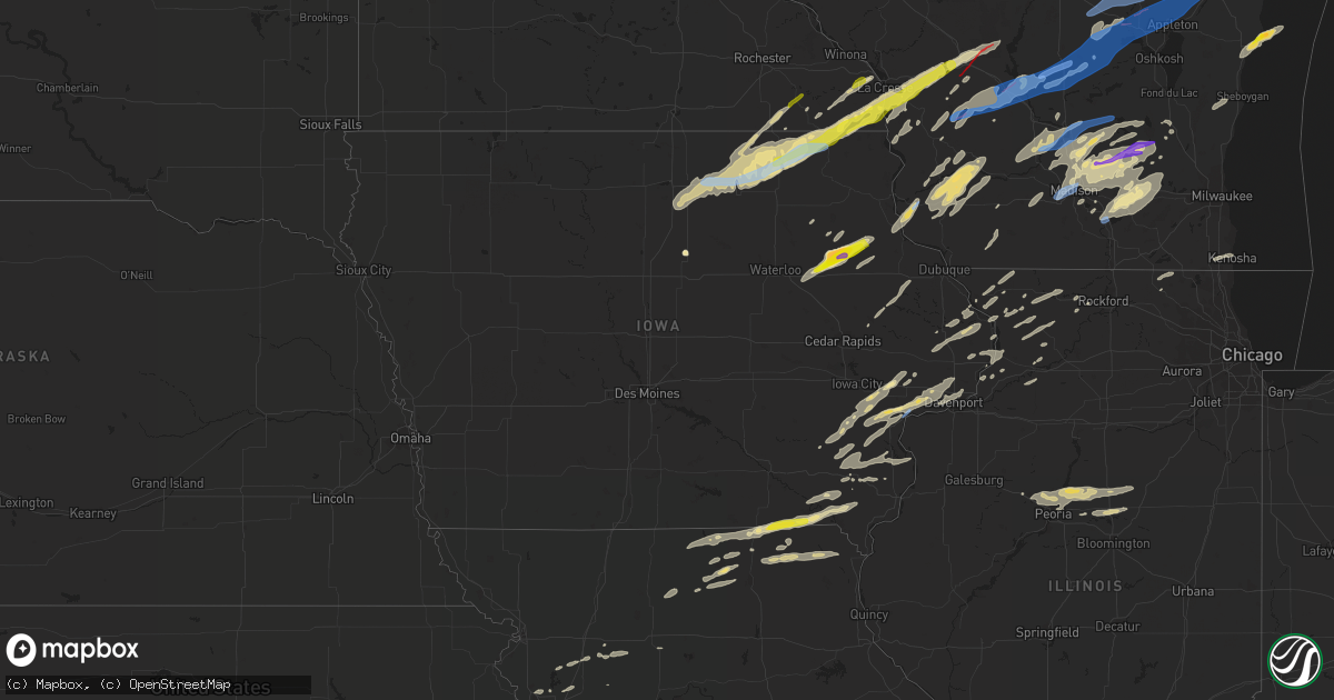
Hail Map in Iowa on June 15, 2022
Get this storm
June 15 map
$229
one time, instant access
Download today. No call, no setup
Keep the $229
Bought the map and want the full workflow? Apply the entire $229 to a subscription within 7 days. None of it is wasted.
Every map, not just this one
This buys you this map. Subscription and you get every map we run, in the markets you choose from a few cities to whole states to nationwide. Plus real-time alerts the moment a storm fires.
Contact data
Name, contact info, occupancy, even credit band for addresses in the footprint. You go from where it hit to who to call.
Become the source they trust
Unlimited branding weather history reports on demand. You already have the documented answer ready for the property owner, and you are the one who showed up with it.
Property data and RoofTrace estimates
Pull up any address you have got, its value and the exact code rules for that jurisdiction, straight from One Click Code. Then RoofTrace estimates the squares, pitch, and roof value, priced the way you price.
Storm reports in Iowa
Iowa
| Date | Description |
|---|---|
| 06/15/20225:13 PM CDT | Storms moving at a good clip - wind 35-40 mph. |
| 06/15/20225:09 PM CDT | Relayed from county sheriff office... Time estimated from radar. |
| 06/15/20225:05 PM CDT | Time estimated from radar... Report from mping: quarter |
| 06/15/20224:35 PM CDT | Branches of unknown size down west of epworth. |
| 06/15/202210:20 AM CDT | Branches around 3 inches in diameter down with pea size hail. Half an inch of rain in 5 minutes. |
| 06/15/202210:10 AM CDT | Trees and power lines downed. |
| 06/15/20227:43 AM CDT | At 1242 AM CDT, severe thunderstorms were located along a line extending from near Walnut to near Emerson, moving east at 35 mph. HAZARD...70 mph wind gusts and quarter size hail. SOURCE...Radar indicated. IMPACT...Hail damage to vehicles is expected. Expect considerable tree damage. Wind damage is also likely to mobile homes, roofs, and outbuildings. Locations impacted include... Atlantic, Griswold, Anita, Lewis, Massena, Cumberland, Marne, Wiota, Lake Anita State Park, Griswold Park, Cold Springs State Park, Atlantic Municipal Airport and Anita Municipal Airport.This includes Interstate 80 between mile markers 50 and 73. |
| 06/15/20227:40 AM CDT | At 1240 AM CDT, a severe thunderstorm was located near Carson, or 17 miles northwest of Red Oak, moving east at 55 mph. HAZARD...70 mph wind gusts and quarter size hail. SOURCE...Radar indicated. IMPACT...Hail damage to vehicles is expected. Expect considerable tree damage. Wind damage is also likely to mobile homes, roofs, and outbuildings. This severe thunderstorm will remain over mainly rural areas of northern Montgomery, northeastern Mills and southeastern Pottawattamie Counties, including the following locations... Botna Bend Park, Old Town Park and Farm Creek Public Wildlife Area. |
| 06/15/20227:35 AM CDT | At 1234 AM CDT, a severe thunderstorm was located near Osage, moving east at 30 mph. HAZARD...Quarter size hail. SOURCE...Radar indicated. IMPACT...Damage to vehicles is expected. This severe thunderstorm will be near... Osage around 1240 AM CDT. Riceville around 110 AM CDT.Other locations impacted by this severe thunderstorm include RockCreek, Idlewilde State Park, Howardville, Brownville, County Roads B20 And T 26, Highways 9 And 218 and Colwell County Park. |
| 06/15/20227:12 AM CDT | At 1211 AM CDT, a severe thunderstorm was located 10 miles east of Audubon, moving northeast at 35 mph. HAZARD...60 mph wind gusts and quarter size hail. SOURCE...Radar indicated. IMPACT...Hail damage to vehicles is expected. Expect wind damage to roofs, siding, and trees. This severe thunderstorm will be near... Guthrie Center around 1230 AM CDT.Other locations in the path of this severe thunderstorm include LakePanorama, Bayard, Springbrook State Park, Bagley, Yale and LakinSlough Game Management Area. |
| 06/15/20225:52 AM CDT | At 1051 AM CDT, severe thunderstorms were located along a line extending from near Lime Springs to near Protivin, moving east at 50 mph. HAZARD...60 mph wind gusts and quarter size hail. SOURCE...Law enforcement has reported nickel sized hail in Alta Vista and some pockets of minor wind damage in since 1030 am. IMPACT...Hail damage to vehicles is expected. Expect wind damage to roofs, siding, and trees. Severe thunderstorms will be near... Ridgeway around 1100 AM CDT. Decorah around 1115 AM CDT.Other locations impacted by these severe thunderstorms includeHesper, Highlandville, Burr Oak, Glenwood Church, Bluffton, ChimneyRock Campground and Locust. |
| 06/15/20225:25 AM CDT | At 1024 AM CDT, a severe thunderstorm was located near Elma, or 13 miles east of Osage, moving northeast at 50 mph. HAZARD...60 mph wind gusts and quarter size hail. SOURCE...Law enforcement. Trees and power lines were downed near Rudd around 1010 am. IMPACT...Hail damage to vehicles is expected. Expect wind damage to roofs, siding, and trees. This severe thunderstorm will be near... Lime Springs around 1045 AM CDT. Cresco around 1050 AM CDT.Other locations impacted by this severe thunderstorm include LylahsMarsh County Park, Vernon Springs County Park, Saratoga, County RoadsB 33 And T 76, County B 17 And Bell Avenue, Maple Leaf and VernonSprings. |
| 06/15/20225:18 AM CDT | At 1018 PM CDT, a severe thunderstorm was located near Rochester, or near Tipton, moving northeast at 50 mph. HAZARD...60 mph wind gusts and half dollar size hail. SOURCE...Radar indicated. IMPACT...Hail damage to vehicles is expected. Expect wind damage to roofs, siding, and trees. This severe thunderstorm will be near... Bennett around 1025 PM CDT. New Liberty and Bennett Park around 1030 PM CDT. Lowden and Big Rock around 1035 PM CDT.Other locations in the path of this severe thunderstorm includeWheatland, Calamus, Toronto, Walnut Grove Park, Sherman Park,Massillon Park, Grand Mound and Lost Nation. |
| 06/15/20225:07 AM CDT | At 1007 PM CDT, a severe thunderstorm was located near Saulsbury Bridge Campground, or near Muscatine, moving east at 50 mph. HAZARD...Ping pong ball size hail and 60 mph wind gusts. SOURCE...Radar indicated. IMPACT...People and animals outdoors will be injured. Expect hail damage to roofs, siding, windows, and vehicles. Expect wind damage to roofs, siding, and trees. This severe thunderstorm will be near... Muscatine, Wilton and Sweetland Center around 1020 PM CDT. Fairport, New Era, Wildcat Den State Park, Shady Creek Campground and Fairport Recreation Area around 1025 PM CDT.Other locations in the path of this severe thunderstorm includeDurant, Montpelier, Stockton, Pleasant Prairie, Midway Beach, Clark'sFerry Recreation Area, Blue Grass, Walcott, Buffalo, Maysville, WestLake Park, Plainview, Davenport, Rock Island, Eldridge, Long Grove,Donahue, Davenport Municipal Airport and Mississippi ValleyFairgrounds. |
| 06/15/20224:47 AM CDT | At 945 AM CDT, a severe thunderstorm was located near Rockford, or 10 miles southeast of Mason City, moving northeast at 55 mph. HAZARD...Quarter size hail. SOURCE...Radar indicated. IMPACT...Damage to vehicles is expected. This severe thunderstorm will be near... Rockford around 950 AM CDT. Rudd around 955 AM CDT. Charles City and Floyd around 1005 AM CDT.Other locations impacted by this severe thunderstorm include CountyRoads B 60 And T 18, Rock Creek, Idlewilde State Park, Roseville,Howardville, Brownville and County Roads B 20 And T 26. |
| 06/15/20222:07 AM CDT | At 707 PM CDT, severe thunderstorms were located along a line extending from Walcott to Muscatine, moving northeast at 60 mph. HAZARD...60 mph wind gusts and quarter size hail. SOURCE...Radar indicated. IMPACT...Hail damage to vehicles is expected. Expect wind damage to roofs, siding, and trees. Severe thunderstorms will be near... Walcott, Maysville and Plainview around 710 PM CDT. Davenport, Eldridge, Donahue and Davenport Municipal Airport around 715 PM CDT. Long Grove, Montpelier, Midway Beach, Wildcat Den State Park, Clark's Ferry Recreation Area, Park View, Pleasant Prairie, Loud Thunder Forest Preserve, Scott County Park and Loud Thunder Scout Camp around 720 PM CDT. Blue Grass, Andalusia, McCausland, Stockton and Buffalo Shores around 725 PM CDT.Other locations in the path of these severe thunderstorms includeBuffalo, Princeton, Cordova, Folletts, West Lake Park, Rock CreekMarina and Campground, Rock Creek Park, Princeton Wildlife Area,Credit Island, Rock Island, Camanche, Albany, Low Moor, MississippiValley Fairgrounds, Rock Island Arsenal, Blackhawk State Park,Moline, East Moline, Silvis, Riverdale, Panorama Park, CampbellsIsland, Bettendorf, Clinton, Le Claire, Hampton, Port Byron, RapidsCity, Fishermans Corner, Pleasant Valley and Illiniwek ForestPreserve. |
| 06/15/20222:00 AM CDT | At 700 PM CDT, a severe thunderstorm was located over Unionville, moving east at 40 mph. HAZARD...60 mph wind gusts and quarter size hail. SOURCE...Radar indicated. IMPACT...Hail damage to vehicles is expected. Expect wind damage to roofs, siding, and trees. Locations impacted include... Unionville, Queen City, Worthington, Livonia and Lemons. |
| 06/14/202211:48 PM CDT | At 448 PM CDT, a severe thunderstorm was located over Wapsipinicon Golf Course, or over Independence, moving northeast at 60 mph. HAZARD...Ping pong ball size hail and 60 mph wind gusts. SOURCE...Radar indicated. IMPACT...People and animals outdoors will be injured. Expect hail damage to roofs, siding, windows, and vehicles. Expect wind damage to roofs, siding, and trees. This severe thunderstorm will be near... Winthrop around 455 PM CDT. Stanley and Jakway Park around 500 PM CDT. Lamont and Aurora around 505 PM CDT.Other locations in the path of this severe thunderstorm includeBackbone State Park. |
| 06/14/202211:14 PM CDT | At 414 AM CDT, a severe thunderstorm was located near Fairbank, or near Oelwein, moving northeast at 35 mph. HAZARD...60 mph wind gusts and quarter size hail. SOURCE...Radar indicated. IMPACT...Hail damage to vehicles is expected. Expect wind damage to roofs, siding, and trees. This severe thunderstorm will remain over mainly rural areas of northwestern Buchanan County, including the following locations... Fontana County Park and Fontana Park. |
| 06/14/202211:09 PM CDT | At 409 AM CDT, a severe thunderstorm was located near Preston, moving northeast at 30 mph. HAZARD...60 mph wind gusts. SOURCE...Radar indicated. IMPACT...Expect damage to roofs, siding, and trees. This severe thunderstorm will be near... Harmony around 415 AM CDT. Preston around 420 AM CDT. Lanesboro around 435 AM CDT.Other locations impacted by this severe thunderstorm includeHenrytown, Choice, Old Barn Campground, Isinours, Hutton,Greenleafton and Peterson. |
| 06/14/202211:07 PM CDT | At 407 AM CDT, a severe thunderstorm was located 3 miles east of Hooper, or 11 miles north of Fremont, moving northeast at 50 mph. HAZARD...60 mph wind gusts and quarter size hail. SOURCE...Radar indicated. IMPACT...Hail damage to vehicles is expected. Expect wind damage to roofs, siding, and trees. This severe thunderstorm will be near... Herman around 425 AM CDT.Other locations in the path of this severe thunderstorm includeTekamah, Little Sioux and Pisgah.This includes Interstate 29 between mile markers 84 and 99. |
| 06/14/202211:03 PM CDT | At 402 AM CDT, a severe thunderstorm was located over Littleton, or 9 miles northwest of Independence, moving north at 35 mph. HAZARD...60 mph wind gusts and quarter size hail. SOURCE...Radar indicated. IMPACT...Hail damage to vehicles is expected. Expect wind damage to roofs, siding, and trees. This severe thunderstorm will be near... Fairbank and Hazleton around 420 AM CDT. |
| 06/14/202210:22 PM CDT | Em reported a tree down on private property. |
| 06/14/20229:58 PM CDT | At 257 AM CDT, severe thunderstorms were located along a line extending from near Reinbeck to 6 miles north of Toledo to near Meskwaki Casino, moving east at 30 mph. HAZARD...60 mph wind gusts. SOURCE...Radar indicated. IMPACT...Expect damage to roofs, siding, and trees. Locations impacted include... Toledo, Tama, La Porte City, Traer, Reinbeck, Dysart, Meskwaki Casino, Gladbrook, Le Grand, Garwin, Montour, Clutier, Elberon, Beaman, Lincoln, Morrison, Vining, Tf Clark State Park, Union Grove State Park and Toledo Municipal Airport.This includes Interstate 380 between mile markers 56 and 61. |
| 06/14/20229:54 PM CDT | At 254 AM CDT, a severe thunderstorm was located over Dike, or 8 miles west of Cedar Falls, moving northeast at 45 mph. HAZARD...60 mph wind gusts and quarter size hail. SOURCE...Radar indicated. IMPACT...Hail damage to vehicles is expected. Expect wind damage to roofs, siding, and trees. Locations impacted include... Waterloo, Cedar Falls, Waverly, Evansdale, Jesup, Hudson, Sumner, Parkersburg, Denver, Tripoli, Dike, Elk Run Heights, Crossroads Mall, Waterloo Municipal Airport, Uni-Dome And McLeod Center, Janesville, Washburn, Dunkerton, Readlyn and Raymond.This includes Interstate 380 between mile markers 60 and 73. |
| 06/14/20229:15 PM CDT | At 214 AM CDT, a severe thunderstorm was located near Eldora, moving northeast at 45 mph. HAZARD...60 mph wind gusts and quarter size hail. SOURCE...Radar indicated. IMPACT...Hail damage to vehicles is expected. Expect wind damage to roofs, siding, and trees. Locations impacted include... Iowa Falls, Eldora, Grundy Center, Reinbeck, Ackley, Dike, Conrad, Hubbard, Wellsburg, Union, Steamboat Rock, Liscomb, Holland, New Providence, Stout, Beaman, Whitten, Clemons, Buckeye and St. Anthony. |
| 06/14/20228:52 PM CDT | At 152 AM CDT, a severe thunderstorm was located 3 miles west of Leshara, or 7 miles south of Fremont, moving northeast at 50 mph. HAZARD...60 mph wind gusts and half dollar size hail. SOURCE...Radar indicated. IMPACT...Hail damage to vehicles is expected. Expect wind damage to roofs, siding, and trees. This severe thunderstorm will be near... Fremont, Leshara and Woodcliff around 155 AM CDT. Valley around 200 AM CDT. Arlington around 205 AM CDT. Bennington around 210 AM CDT.Other locations in the path of this severe thunderstorm includeKennard, Blair and Fort Calhoun. |
| 06/14/20228:47 PM CDT | At 147 AM CDT, a severe thunderstorm was located near Hospers, or 7 miles south of Sheldon, moving northeast at 50 mph. HAZARD...60 mph wind gusts and quarter size hail. SOURCE...Radar indicated. IMPACT...Hail damage to vehicles is expected. Expect wind damage to roofs, siding, and trees. This severe thunderstorm will be near... Sheldon and Paullina around 150 AM CDT. Archer around 155 AM CDT. Sanborn, Primghar and Sutherland around 200 AM CDT.Other locations in the path of this severe thunderstorm includeHartley, Melvin and Ocheyedan. |
| 06/14/20228:41 PM CDT | At 139 AM CDT, severe thunderstorms were located along a line extending from near Jefferson to near Stuart, moving northeast at 55 mph. HAZARD...60 mph wind gusts and penny size hail. SOURCE...Radar indicated. At 134 AM, Guthrie County emergency management reported 65 mph wind near the intersection of 310th street and Highway 25. IMPACT...Expect damage to roofs, siding, and trees. Locations impacted include... Urbandale, Waukee, Boone, Grimes, Perry, Jefferson, Adel, Guthrie Center, Madrid, Ogden, Stuart, Dallas Center, Granger, Panora, Woodward, Lake Panorama, Boone Speedway, Redfield, Grand Junction and Dexter.This includes Interstate 80 near mile marker 100. |
| 06/14/20228:23 PM CDT | Reported near the lodge at windy ridge... Time estimated from radar. |
| 06/14/20228:03 PM CDT | At 103 AM CDT, severe thunderstorms were located along a line extending from 9 miles east of Manning to Audubon to 8 miles north of Atlantic, moving northeast at 45 mph. HAZARD...60 mph wind gusts and nickel size hail. SOURCE...Radar indicated. IMPACT...Expect damage to roofs, siding, and trees. Locations impacted include... Jefferson, Audubon, Guthrie Center, Coon Rapids, Lake Panorama, Exira, Scranton, Bayard, Churdan, Templeton, Bagley, Dedham, Brayton, Willey, Ralston, Gray, Audubon County Airport and Springbrook State Park. |
| 06/14/20227:13 PM CDT | Relayed a report from fire department of tree down and transformer on fire at this location. |
| 06/14/20227:08 PM CDT | Report from mping: 3-inch tree limbs broken; power poles broken. |
| 06/14/20227:08 PM CDT | A local report indicates 68 MPH wind near MUSCATINE |
All States Impacted by Hail Map on June 15, 2022
Cities Impacted by Hail Map on June 15, 2022
- Harmony, MN
- Scipio Center, NY
- Rib Lake, WI
- Medford, WI
- Wautoma, WI
- Neshkoro, WI
- Montello, WI
- Westfield, WI
- Oxford, WI
- Grand Marsh, WI
- Cottage Grove, WI
- Stoughton, WI
- Ishpeming, MI
- Champion, MI
- Theresa, WI
- Viroqua, WI
- Mayville, WI
- Lomira, WI
- Traverse City, MI
- Manchester, IA
- Greeley, IA
- La Valle, WI
- Nunda, NY
- Mount Morris, NY
- Piedmont, AL
- Birmingham, AL
- Tampico, IL
- Prophetstown, IL
- Rock Falls, IL
- Merrill, WI
- Brokaw, WI
- Wausau, WI
- Cascade, WI
- Plymouth, WI
- Sheboygan Falls, WI
- Waldo, WI
- Lanesboro, MN
- Preston, MN
- Chatham, MI
- Trenary, MI
- Twin Lake, MI
- Muskegon, MI
- Eckerman, MI
- Fayette, IA
- Mcfarland, WI
- Bristol, WI
- Kenosha, WI
- Heflin, AL
- Wedowee, AL
- Gowen, MI
- Trufant, MI
- Readstown, WI
- Viola, WI
- Dodgeville, WI
- Blue Mounds, WI
- Mount Horeb, WI
- Salem, IA
- Merrimac, WI
- Lodi, WI
- Portage, WI
- Pardeeville, WI
- North Freedom, WI
- Plain, WI
- Prairie Du Sac, WI
- Baraboo, WI
- Sauk City, WI
- Delta, AL
- Morrison, IL
- Fenton, IL
- Deerbrook, WI
- Two Rivers, WI
- Manitowoc, WI
- Eureka, IL
- Lima, NY
- Bellevue, IA
- Geneva, NY
- Romulus, NY
- Pearl City, IL
- Tiger, GA
- Cedartown, GA
- Rockmart, GA
- Aragon, GA
- Sumner, IA
- Antigo, WI
- Newberry, MI
- Paradise, MI
- Grawn, MI
- Wonewoc, WI
- Wisconsin Dells, WI
- Mauston, WI
- Hillsboro, WI
- Lyndon Station, WI
- Friendship, WI
- Adams, WI
- Kendall, WI
- Elroy, WI
- La Farge, WI
- Hermansville, MI
- Spalding, MI
- Escanaba, MI
- Wilson, MI
- Wells, MI
- Manistique, MI
- Bark River, MI
- Daggett, MI
- Wausaukee, WI
- Stephenson, MI
- Amberg, WI
- Wetmore, MI
- Cornell, MI
- Powers, MI
- Rapid River, MI
- Nahma, MI
- Carney, MI
- Gladstone, MI
- Nadeau, MI
- Vulcan, MI
- Weyauwega, WI
- Waupaca, WI
- Wild Rose, WI
- Pine River, WI
- Watertown, WI
- Blue River, WI
- Fennimore, WI
- Stitzer, WI
- Muscoda, WI
- Montfort, WI
- Avoca, WI
- Highland, WI
- Richland Center, WI
- Lone Rock, WI
- Mount Hope, WI
- Woodman, WI
- Boscobel, WI
- Lancaster, WI
- Bruce, WI
- Holcombe, WI
- Wilton, WI
- Tomah, WI
- Garnavillo, IA
- Patch Grove, WI
- Glen Haven, WI
- Guttenberg, IA
- Bloomington, WI
- Prairie Du Chien, WI
- Bagley, WI
- Gurley, AL
- Owens Cross Roads, AL
- Gays Mills, WI
- Anamosa, IA
- Monticello, IA
- Sterling, IL
- Novinger, MO
- Green Castle, MO
- Milan, MO
- Green City, MO
- Anniston, AL
- Disputanta, VA
- Petersburg, VA
- Mouth Of Wilson, VA
- Highlands, NC
- Maquoketa, IA
- Kent, IL
- Blountsville, AL
- Leaf River, IL
- Winnebago, IL
- Shannon, IL
- Lanark, IL
- Mount Carroll, IL
- Hudson, IN
- Wolcottville, IN
- Angola, IN
- Lagrange, IN
- Alexandria, AL
- Jacksonville, AL
- Wellington, AL
- Franklin, GA
- Marion, NC
- Hollister, NC
- Littleton, NC
- Lake Como, PA
- Starlight, PA
- Hankins, NY
- Callicoon, NY
- Long Eddy, NY
- Preston Park, PA
- Starrucca, PA
- Hancock, NY
- Lakewood, PA
- Damascus, PA
- Equinunk, PA
- Unionville, MO
- Worthington, MO
- Polo, MO
- Lathrop, MO
- Turney, MO
- Freeport, IL
- Ridott, IL
- Reidsville, GA
- Elba, AL
- Gainestown, AL
- Toccoa, GA
- Adrian, GA
- Swainsboro, GA
- Troy, AL
- Hamilton, GA
- Pine Mountain, GA
- Shiloh, GA
- Pine Mountain Valley, GA
- Lowell, WI
- Waterloo, WI
- Juneau, WI
- Marshall, WI
- Rio, WI
- Madison, WI
- Columbus, WI
- Waunakee, WI
- Deforest, WI
- Windsor, WI
- Reeseville, WI
- Beaver Dam, WI
- Sun Prairie, WI
- West Liberty, IA
- West Branch, IA
- Atalissa, IA
- Riverside, IA
- Hampton, GA
- Ozark, AL
- Midland City, AL
- Fort Rucker, AL
- Skipperville, AL
- Newville, AL
- Taylorsville, GA
- Kingston, GA
- Rome, GA
- Silver Creek, GA
- Faunsdale, AL
- Thomaston, GA
- Pittsview, AL
- Eufaula, AL
- Hurtsboro, AL
- Hatchechubbee, AL
- Dexter, GA
- Safford, AL
- Orrville, AL
- Brownsville, MN
- Box Springs, GA
- Glenwood, GA
- Red Level, AL
- Sparta, GA
- Milledgeville, GA
- West Point, GA
- Cataula, GA
- Dawson, GA
- Bronwood, GA
- Phenix City, AL
- Alma, MI
- Elwell, MI
- Saint Louis, MI
- Shepherd, MI
- Eastman, GA
- Tyler, AL
- Selma, AL
- Abbeville, AL
- Clopton, AL
- Clayton, AL
- Louisville, AL
- Notasulga, AL
- Auburn, AL
- La Crescent, MN
- Tipton, IA
- Concord, GA
- East Dublin, GA
- Waco, GA
- Bremen, GA
- Carrollton, GA
- Hartford, KS
- Olpe, KS
- Fort Valley, GA
- Downing, MO
- Lancaster, MO
- Cantril, IA
- Donnellson, IA
- Pulaski, IA
- Bloomfield, IA
- Farmington, IA
- Milton, IA
- Bonaparte, IA
- Memphis, MO
- Mount Sterling, IA
- Keosauqua, IA
- Cuthbert, GA
- Morris, GA
- Brantley, AL
- Luverne, AL
- Grantville, GA
- Brundidge, AL
- Washington, IA
- Ainsworth, IA
- Elma, IA
- Five Points, AL
- Lagrange, GA
- Ideal, GA
- Marshallville, GA
- Perry, GA
- Oglethorpe, GA
- Reynolds, GA
- Leslie, GA
- Smithville, GA
- Cascade, IA
- Worthington, IA
- Farley, IA
- Wapello, IA
- Mount Pleasant, IA
- Winfield, IA
- Morning Sun, IA
- Wayland, IA
- Oakville, IA
- Mediapolis, IA
- Olds, IA
- Yarmouth, IA
- Mount Union, IA
- Queen City, MO
- Roanoke Rapids, NC
- Bowdon, GA
- Dozier, AL
- Griffin, GA
- Fayetteville, GA
- Brooks, GA
- Mossville, IL
- Benson, IL
- Roanoke, IL
- Metamora, IL
- Peoria, IL
- Lowpoint, IL
- Princeville, IL
- Dunlap, IL
- Washburn, IL
- Flanagan, IL
- Minonk, IL
- Peoria Heights, IL
- El Paso, IL
- Edwards, IL
- Washington, IL
- Brimfield, IL
- East Peoria, IL
- Chillicothe, IL
- Poynette, WI
- Randolph, WI
- Arlington, WI
- Doylestown, WI
- Fall River, WI
- Morrisonville, WI
- Adairsville, GA
- Eatonton, GA
- Huntsville, AL
- Smiths Station, AL
- Camp Douglas, WI
- Warrens, WI
- Banks, AL
- Warm Springs, GA
- Lumpkin, GA
- Omaha, GA
- Cadwell, GA
- Shellman, GA
- Georgetown, GA
- Fort Gaines, GA
- Dublin, GA
- Luthersville, GA
- Clio, AL
- Hazleton, IA
- Dundee, IA
- Edgewood, IA
- Lamont, IA
- Winthrop, IA
- Independence, IA
- Strawberry Point, IA
- Aurora, IA
- Stanley, IA
- Lakemont, GA
- Buena Vista, GA
- Ellaville, GA
- Newnan, GA
- Woodland, AL
- Madison, KS
- Springville, IA
- Central City, IA
- Muscatine, IA
- Elizabeth, IL
- Kingston, MO
- Ariton, AL
- Stockbridge, GA
- Jonesboro, GA
- Monroeville, AL
- Pinckney, MI
- Gregory, MI
- Jackson, MI
- Munith, MI
- Grass Lake, MI
- Whitmore Lake, MI
- Chelsea, MI
- Stockbridge, MI
- Dexter, MI
- Rives Junction, MI
- Pleasant Lake, MI
- Richmond, MO
- Marion, AL
- Repton, AL
- Port Charlotte, FL
- Johnson Creek, WI
- Lake Mills, WI
- Jefferson, WI
- Davenport, IA
- Blue Grass, IA
- Bettendorf, IA
- Woodbury, GA
- Molena, GA
- Leesburg, GA
- Orland, IN
- Fremont, IN
- Lawrence, KS
- Salem, AL
- Seale, AL
- Sperry, IA
- Hogansville, GA
- Palmetto, GA
- Lanett, AL
- Douglasville, GA
- Moreland, GA
- Zebulon, GA
- Lafayette, AL
- Williamson, GA
- Manchester, GA
- Senoia, GA
- Whitesburg, GA
- Milner, GA
- Greenville, GA
- Peachtree City, GA
- Fairburn, GA
- Sharpsburg, GA
- Gay, GA
- Meansville, GA
- Buchanan, GA
- Dallas, GA
- Temple, GA
- Villa Rica, GA
- Osage City, KS
- Durant, IA
- Crawfordsville, IA
- Donahue, IA
- Wilton, IA
- Columbus Junction, IA
- Dixon, IA
- Letts, IA
- Nichols, IA
- Eldridge, IA
- Walcott, IA
- Long Grove, IA
- Columbus City, IA
- Conesville, IA
- Stockton, IA
- Opelika, AL
- Gallion, AL
- Greensboro, AL
- Atmore, AL
- Columbus, GA
- Midland, GA
- Upatoi, GA
- Woodland, GA
- Fort Benning, GA
- Midway, AL
- Frisco City, AL
- Murphy, NC
- Marble, NC
- Charles City, IA
- Talbotton, GA
- Alamo, GA
- Sardis, AL
- Ithaca, NY
- Brooktondale, NY
- Tuskegee, AL
- Lost Nation, IA
- Grand Mound, IA
- Spragueville, IA
- Miles, IA
- Delmar, IA
- Charlotte, IA
- Wheatland, IA
- Preston, IA
- Congerville, IL
- Secor, IL
- Gridley, IL
- Haddock, GA
- Brighton, IA
- Lone Tree, IA
- Iowa City, IA
- Mcdonough, GA
- Hanover, IL
- Powder Springs, GA
- Minter, AL
- Iowa Falls, IA
- Warren, IL
- Apple River, IL
- Stockton, IL
- Fruithurst, AL
- East Bethany, NY
- Pavilion, NY
- Wyoming, NY
- Canton, MN
- Plattsburg, MO
- Marshall, MI
- Bellevue, MI
- Battle Creek, MI
- Smithville, MO
- Catawissa, PA
- Danville, PA
- Glenwood, AL
- Marion Junction, AL
- Coleman, GA
- Roanoke, AL
- Flovilla, GA
- Jackson, GA
- Forsyth, GA
- Livonia, NY
- Hemlock, NY
- Hayesville, NC
- Clarkdale, GA
- Austell, GA
- Kansas City, MO
- Platte City, MO
- Owego, NY
- Newark Valley, NY
- Endicott, NY
- Caledonia, MN
- Mechanicsville, VA
- Woodstock, IL
- Mount Airy, GA
- Pecatonica, IL
- Opp, AL
- Soperton, GA
- Tarrytown, GA
- Rockledge, GA
- Newbern, AL
- Fort Mitchell, AL
- Vidalia, GA
- Ellerslie, GA
- Thomasville, AL
- Grove Hill, AL
- Dickinson, AL
- Moundville, AL
- Wadley, AL
- Union Springs, AL
- King William, VA
- Savanna, IL
- Sabula, IA
- Warsaw, NY
- Humphreys, MO
- Galt, MO
- Laredo, MO
- Forreston, IL
- Chadwick, IL
- Milledgeville, IL
- Polo, IL
- Tuscaloosa, AL
- Fosters, AL
- Warner Robins, GA
- Cowgill, MO
- Braymer, MO
- Hamilton, MO
- Kahoka, MO
- Wyaconda, MO
- Rutledge, MO
- Greentop, MO
- Luray, MO
- Arbela, MO
- Saint Patrick, MO
- Gorin, MO
- Lyons, GA
- Hiram, GA
- Greenville, AL
- Acworth, GA
- Marietta, GA
- Kennesaw, GA
- Oxford, AL
- Magnolia, AL
- Pine Hill, AL
- Little River, AL
- Colwell, IA
- Cresco, IA
- Ridgeway, IA
- Lime Springs, IA
- Alta Vista, IA
- Orchard, IA
- New Hampton, IA
- Riceville, IA
- Elko, GA
- De Soto, WI
- Genoa, WI
- Spring Grove, MN
- Mabel, MN
- Decorah, IA
- Muscadine, AL
- Neosho, WI
- Ladysmith, WI
- Vestaburg, MI
- Lakeview, MI
- Riverdale, MI
- Stanton, MI
- Breckenridge, MI
- Edmore, MI
- New Market, AL
- Silver Springs, NY
- Helenville, WI
- Fort Atkinson, WI
- Cambridge, WI
- Camanche, IA
- Cordova, IL
- Collins, GA
- Tuskegee Institute, AL
- Goose Lake, IA
- Clinton, IA
- De Witt, IA
- Cayuta, NY
- Horseheads, NY
- Millport, NY
- Montour Falls, NY
- Newfield, NY
- Odessa, NY
- Alpine, NY
- Palmetto, FL
- Parrish, FL
- Wimauma, FL
- Ruskin, FL
- Bennett, IA
- Myakka City, FL
- Thomaston, AL
- Catherine, AL
- Uniontown, AL
- Butler, GA
- Metter, GA
- Ackley, IA
- Hampton, IA
- Coon Valley, WI
- Mauk, GA
- Ferryville, WI
- Winston, GA
- Emporia, KS
- Neosho Rapids, KS
- Leicester, NY
- Perry, NY
- Ontario, WI
- Dahlonega, GA
- Graham, AL
- Hanover, VA
- Manquin, VA
- Nebo, NC
- Kearney, MO
- Liberty, MO
- Jack, AL
- Cusseta, GA
- Sarasota, FL
- Union Springs, NY
- Aurora, NY
- Ovid, NY
- Norwalk, WI
- Harvard, IL
- Hebron, IL
- Erie, IL
- Albany, IL
- Tallapoosa, GA
- Stockport, IA
- Ionia, IA
- West Salem, WI
- Sparta, WI
- Little Cedar, IA
- Osage, IA
- Spring Valley, MN
- McIntire, IA
- Stoddard, WI
- Rockwell, IA
- Sheffield, IA
- Thornton, IA
- Le Roy, MN
- Wykoff, MN
- Rudd, IA
- Nora Springs, IA
- Mason City, IA
- La Crosse, WI
- Cashton, WI
- Swaledale, IA
- Rockford, IA
- Eitzen, MN
- Rockland, WI
- Floyd, IA
- Ostrander, MN
- Chester, IA
- Hokah, MN
- Bangor, WI
- Chaseburg, WI
- Necedah, WI
- Dorchester, IA
- Peterson, MN
- Rushford, MN
- Houston, MN
- Attica, NY
- Ellijay, GA
- Chatsworth, GA
- Atlanta, GA
- Enterprise, AL
- New Brockton, AL
- Bay City, MI
- Hillsboro, IA
- Birmingham, IA
- Waverly, AL
- Camp Hill, AL
- Grady, AL
- Glenwood, MO
- Coatsville, MO
- Ixonia, WI
- Oconomowoc, WI
- Edgerton, WI
- Sullivan, WI
- Ceresco, MI
- Castalia, NC
- Nashville, NC
- Clayton, GA
- Clarkesville, GA
- Hardaway, AL
- Waupun, WI
- Fox Lake, WI
- Burnett, WI
- Cambria, WI
- Dane, WI
- Clyman, WI
- Deerfield, WI
- Middleton, WI
- Verona, WI
- Horicon, WI
- Iron Ridge, WI
- Hustisford, WI
- Dansville, NY
- Bradenton, FL
- Monticello, GA
- Unadilla, GA
- Hawkinsville, GA
- Jesup, IA
- Hayden, AL
- Walton, NY
- Chillicothe, MO
- Fairfield, AL
- Saint Paul, IA
- West Point, IA
- Pollock, MO
- Livonia, MO
- Bostic, NC
- Chester, VA
- Chesterfield, VA
- Shullsburg, WI
- Darlington, WI
- Mineral Point, WI
- Berkshire, NY
- Wauzeka, WI
- New London, IA
- Hillsboro, GA
- Gray, GA
- Virgil, KS
- Hamilton, KS
- Eureka, KS
- Jones, AL
- Arlington, IA
- Fulton, IL
- Plains, GA
- Bradford, IA
- Lawler, IA
- Westby, WI
- Dakota, MN
- Elmore, AL
- Wetumpka, AL
- Manawa, WI
- Shiocton, WI
- Bonduel, WI
- Pulaski, WI
- Fremont, WI
- New London, WI
- Black Creek, WI
- Seymour, WI
- Wittenberg, WI
- Bowler, WI
- Tigerton, WI
- Crivitz, WI
- Oneida, WI
- New Lisbon, WI
- Redgranite, WI
- Appleton, WI
- Suamico, WI
- Brussels, WI
- Winneconne, WI
- Green Bay, WI
- Berlin, WI
- Sturgeon Bay, WI
- Hancock, WI
- Poy Sippi, WI
- Hortonville, WI
- Neenah, WI
- New Franken, WI
- Princeton, WI
- Greenville, WI
- Luxemburg, WI
- Kaukauna, WI
- De Pere, WI
- Coloma, WI
- Larsen, WI
- Stevens Point, WI
- Rudolph, WI
- Eland, WI
- Wisconsin Rapids, WI
- Hatley, WI
- Custer, WI
- Rosholt, WI
- Iola, WI
- Friesland, WI
- Wyocena, WI
- Amherst, WI
- Almond, WI
- Clintonville, WI
- Scandinavia, WI
- Oconto, WI
- Little Suamico, WI
- Krakow, WI
- Oconto Falls, WI
- Marinette, WI
- Sobieski, WI
- Abrams, WI
- Lena, WI
- Ogdensburg, WI
- Peshtigo, WI
- Bear Creek, WI
- Nichols, WI
- Fountain, MN
- Elkport, IA


