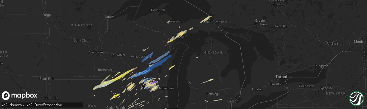
Hail Map in Michigan on June 15, 2022
The weather event in Michigan on June 15, 2022 includes Wind, Hail, and Tornado maps. 15 states and 840 cities were impacted and suffered possible damage. The total estimated number of properties impacted is 338.
Want more than just the map?
Turn this storm into a full workflow.
- Owner + property data so you know who to knock
- OnDemand branded weather history reports to win the "did we even have hail?" argument
- RoofTrace estimate so reps stop guessing numbers at the door
Bought this map? Upgrade within 7 days and we'll credit the $230. (10-15 min setup call)
Wind
Hail
Tornado
338
Estimated number of impacted properties by a 1.00" hail or larger0
Estimated number of impacted properties by a 1.75" hail or larger0
Estimated number of impacted properties by a 2.50" hail or largerStorm reports in Michigan
Michigan
| Date | Description |
|---|---|
| 06/15/20229:30 AM CDT | Poplar tree snapped halfway up the tree on the bluff in gladstone. Another tree was snapped near the base of the trunk. Report via social media. |
| 06/15/20229:28 AM CDT | Escanaba public safety dispatch reports of a damaged tree on a power line near the michigan dnr station in escanaba. |
| 06/15/20225:51 AM CDT | At 1051 PM EDT, severe thunderstorms were located along a line extending from Traverse City to Buckley, moving east at 30 mph. HAZARD...60 mph wind gusts and penny size hail. SOURCE...Radar indicated. IMPACT...Expect damage to roofs, siding, and trees. Severe thunderstorms will be near... Traverse City and Traverse City State Park around 1055 PM EDT. Kingsley around 1105 PM EDT. Williamsburg around 1110 PM EDT.Other locations in the path of these severe thunderstorms includeBarker Creek, Fife Lake, Rapid City, Kalkaska, South Boardman andAntrim. |
| 06/15/20225:25 AM CDT | At 1025 AM EDT, a severe thunderstorm was located over Gladstone, or 7 miles north of Escanaba, moving northeast at 45 mph. HAZARD...60 mph wind gusts and quarter size hail. SOURCE...Radar indicated. IMPACT...Hail damage to vehicles is expected. Expect wind damage to roofs, siding, and trees. This severe thunderstorm will be near... Rapid River around 1030 AM EDT. |
| 06/15/20225:18 AM CDT | At 1017 PM EDT, severe thunderstorms were located along a line extending from near Whitefish Point to near Raco to 8 miles northeast of Allenville, moving northeast at 60 mph. HAZARD...60 mph wind gusts. SOURCE...Radar indicated. IMPACT...Expect damage to roofs, siding, and trees. Severe thunderstorms will be near... Dafter and Brimley State Park around 1025 PM EDT. Sault Ste. Marie around 1030 PM EDT. Pickford, Kelden and Stalwart around 1035 PM EDT.Other locations in the path of these severe thunderstorms includeBarbeau and Munuscong. |
| 06/15/20224:43 AM CDT | At 942 AM EDT/842 AM CDT/, a severe thunderstorm was located 8 miles north of Stephenson, or 27 miles southwest of Escanaba, moving northeast at 35 mph. HAZARD...60 mph wind gusts and quarter size hail. SOURCE...Radar indicated. IMPACT...Hail damage to vehicles is expected. Expect wind damage to roofs, siding, and trees. Locations impacted include... Escanaba. |
| 06/15/20224:29 AM CDT | At 929 PM EDT, severe thunderstorms were located along a line extending from near Grand Marais to near Curtis, moving east at 35 mph. HAZARD...60 mph wind gusts and quarter size hail. SOURCE...Radar indicated. IMPACT...Hail damage to vehicles is expected. Expect wind damage to roofs, siding, and trees. Locations impacted include... Muskallonge State Park. |
| 06/15/20224:25 AM CDT | 8 inch tree limb down at intersection of 4th street and state street. Time estimated by radar. |
| 06/15/20224:23 AM CDT | At 923 PM EDT, severe thunderstorms were located along a line extending from 10 miles northwest of Grand Marais to Gould City to 12 miles west of Saint James On Beaver Island, moving northeast at 60 mph. HAZARD...60 mph wind gusts. SOURCE...Radar indicated. IMPACT...Expect damage to roofs, siding, and trees. Severe thunderstorms will be near... Engadine around 930 PM EDT. Naubinway around 935 PM EDT. Gilchrist and Garnet around 940 PM EDT.Other locations in the path of these severe thunderstorms includeHulbert, Eckerman, Epoufette, Brevort, Strongs, Trout Lake, EastLake, Bayview Campground and Fibre. |
| 06/15/20224:22 AM CDT | At 921 PM EDT, severe thunderstorms were located along a line extending from near Seney to 16 miles southeast of Manistique, moving east at 40 mph. HAZARD...60 mph wind gusts and quarter size hail. SOURCE...Radar indicated. IMPACT...Hail damage to vehicles is expected. Expect wind damage to roofs, siding, and trees. Severe thunderstorms will be near... Seney around 930 PM EDT. |
| 06/15/20224:10 AM CDT | Tree down. Time estimated by radar. |
| 06/15/20224:03 AM CDT | At 903 PM EDT, a severe thunderstorm was located near Chatham, or 8 miles southwest of Munising, moving northeast at 55 mph. HAZARD...60 mph wind gusts and quarter size hail. SOURCE...Radar indicated. IMPACT...Hail damage to vehicles is expected. Expect wind damage to roofs, siding, and trees. This severe thunderstorm will be near... Munising around 915 PM EDT. Pictured Rocks National Lakeshore Miners Castle and Shingleton around 920 PM EDT.Other locations in the path of this severe thunderstorm includeChapel Lake. |
| 06/15/20223:49 AM CDT | Central dispatch reported scattered trees down in the western and central part of huron county. Some locations include sebewaing... Owendale... Filion... And ubly |
| 06/15/20223:40 AM CDT | Central dispatch reported over a dozen trees downed and snapped across northern tuscola county. |
| 06/15/20223:25 AM CDT | Large limbs down. |
| 06/15/20223:20 AM CDT | Numerous trees down in the area of tittabawassee and lawndale roads. Time radar estimated. |
| 06/15/20223:12 AM CDT | Saginaw international airport wind gust. |
| 06/15/20221:51 AM CDT | At 651 PM CDT, severe thunderstorms were located along a line extending from 7 miles southeast of Pound to 9 miles northeast of Oconto to 12 miles west of Sturgeon Bay to near Luxemburg to Bellevue Town, moving northeast at 70 mph. HAZARD...70 mph wind gusts. SOURCE...Radar indicated. IMPACT...Expect considerable tree damage. Damage is likely to mobile homes, roofs, and outbuildings. Severe thunderstorms will be near... Bay Shore Park, Algoma and Luxemburg around 700 PM CDT. Marinette, Sturgeon Bay and Menominee around 705 PM CDT. Egg Harbor around 710 PM CDT.Other locations in the path of these severe thunderstorms includeJacksonport, Ephraim and Newport State Park. |
| 06/15/20221:15 AM CDT | At 615 PM CDT, severe thunderstorms were located along a line extending from near Navarino Wildlife Area to 8 miles north of Black Creek to 9 miles north of Little Chute to near Darboy, moving northeast at 75 mph. HAZARD...70 mph wind gusts. SOURCE...Radar indicated. IMPACT...Expect considerable tree damage. Damage is likely to mobile homes, roofs, and outbuildings. Severe thunderstorms will be near... Green Bay, Pulaski and Bellevue Town around 625 PM CDT. Gillett around 630 PM CDT. Bay Shore Park and Denmark around 635 PM CDT.Other locations in the path of these severe thunderstorms includeOconto, Luxemburg, Kewaunee, Algoma, Marinette, Sturgeon Bay,Menominee and Egg Harbor. |
| 06/15/202212:56 AM CDT | At 556 AM CDT, a severe thunderstorm was located 8 miles west of Tipler, or 13 miles southwest of Iron River, moving northeast at 40 mph. HAZARD...60 mph wind gusts. SOURCE...Radar indicated. IMPACT...Expect damage to roofs, siding, and trees. This severe thunderstorm will be near... Wisconsin Slough Natural Area around 605 AM CDT. |
| 06/14/202210:06 PM CDT | A few trees down near bates and sayler rd. |
| 06/14/20229:50 PM CDT | Delayed report from social media... Estimated brief quarter size hail. Time estimated from radar. |
| 06/14/20229:31 PM CDT | Awos at chippewa county intl aiport. |
| 06/14/20228:08 PM CDT | Tree down and large swing blown down. Report via social media. |
| 06/14/20227:10 PM CDT | Trees down. Report via social media with picture. |
All States Impacted by Hail Map on June 15, 2022
Cities Impacted by Hail Map on June 15, 2022
- Harmony, MN
- Scipio Center, NY
- Rib Lake, WI
- Medford, WI
- Wautoma, WI
- Neshkoro, WI
- Montello, WI
- Westfield, WI
- Oxford, WI
- Grand Marsh, WI
- Cottage Grove, WI
- Stoughton, WI
- Ishpeming, MI
- Champion, MI
- Theresa, WI
- Viroqua, WI
- Mayville, WI
- Lomira, WI
- Traverse City, MI
- Manchester, IA
- Greeley, IA
- La Valle, WI
- Nunda, NY
- Mount Morris, NY
- Piedmont, AL
- Birmingham, AL
- Tampico, IL
- Prophetstown, IL
- Rock Falls, IL
- Merrill, WI
- Brokaw, WI
- Wausau, WI
- Cascade, WI
- Plymouth, WI
- Sheboygan Falls, WI
- Waldo, WI
- Lanesboro, MN
- Preston, MN
- Chatham, MI
- Trenary, MI
- Twin Lake, MI
- Muskegon, MI
- Eckerman, MI
- Fayette, IA
- Mcfarland, WI
- Bristol, WI
- Kenosha, WI
- Heflin, AL
- Wedowee, AL
- Gowen, MI
- Trufant, MI
- Readstown, WI
- Viola, WI
- Dodgeville, WI
- Blue Mounds, WI
- Mount Horeb, WI
- Salem, IA
- Merrimac, WI
- Lodi, WI
- Portage, WI
- Pardeeville, WI
- North Freedom, WI
- Plain, WI
- Prairie Du Sac, WI
- Baraboo, WI
- Sauk City, WI
- Delta, AL
- Morrison, IL
- Fenton, IL
- Deerbrook, WI
- Two Rivers, WI
- Manitowoc, WI
- Eureka, IL
- Lima, NY
- Bellevue, IA
- Geneva, NY
- Romulus, NY
- Pearl City, IL
- Tiger, GA
- Cedartown, GA
- Rockmart, GA
- Aragon, GA
- Sumner, IA
- Antigo, WI
- Newberry, MI
- Paradise, MI
- Grawn, MI
- Wonewoc, WI
- Wisconsin Dells, WI
- Mauston, WI
- Hillsboro, WI
- Lyndon Station, WI
- Friendship, WI
- Adams, WI
- Kendall, WI
- Elroy, WI
- La Farge, WI
- Hermansville, MI
- Spalding, MI
- Escanaba, MI
- Wilson, MI
- Wells, MI
- Manistique, MI
- Bark River, MI
- Daggett, MI
- Wausaukee, WI
- Stephenson, MI
- Amberg, WI
- Wetmore, MI
- Cornell, MI
- Powers, MI
- Rapid River, MI
- Nahma, MI
- Carney, MI
- Gladstone, MI
- Nadeau, MI
- Vulcan, MI
- Weyauwega, WI
- Waupaca, WI
- Wild Rose, WI
- Pine River, WI
- Watertown, WI
- Blue River, WI
- Fennimore, WI
- Stitzer, WI
- Muscoda, WI
- Montfort, WI
- Avoca, WI
- Highland, WI
- Richland Center, WI
- Lone Rock, WI
- Mount Hope, WI
- Woodman, WI
- Boscobel, WI
- Lancaster, WI
- Bruce, WI
- Holcombe, WI
- Wilton, WI
- Tomah, WI
- Garnavillo, IA
- Patch Grove, WI
- Glen Haven, WI
- Guttenberg, IA
- Bloomington, WI
- Prairie Du Chien, WI
- Bagley, WI
- Gurley, AL
- Owens Cross Roads, AL
- Gays Mills, WI
- Anamosa, IA
- Monticello, IA
- Sterling, IL
- Novinger, MO
- Green Castle, MO
- Milan, MO
- Green City, MO
- Anniston, AL
- Disputanta, VA
- Petersburg, VA
- Mouth Of Wilson, VA
- Highlands, NC
- Maquoketa, IA
- Kent, IL
- Blountsville, AL
- Leaf River, IL
- Winnebago, IL
- Shannon, IL
- Lanark, IL
- Mount Carroll, IL
- Hudson, IN
- Wolcottville, IN
- Angola, IN
- Lagrange, IN
- Alexandria, AL
- Jacksonville, AL
- Wellington, AL
- Franklin, GA
- Marion, NC
- Hollister, NC
- Littleton, NC
- Lake Como, PA
- Starlight, PA
- Hankins, NY
- Callicoon, NY
- Long Eddy, NY
- Preston Park, PA
- Starrucca, PA
- Hancock, NY
- Lakewood, PA
- Damascus, PA
- Equinunk, PA
- Unionville, MO
- Worthington, MO
- Polo, MO
- Lathrop, MO
- Turney, MO
- Freeport, IL
- Ridott, IL
- Reidsville, GA
- Elba, AL
- Gainestown, AL
- Toccoa, GA
- Adrian, GA
- Swainsboro, GA
- Troy, AL
- Hamilton, GA
- Pine Mountain, GA
- Shiloh, GA
- Pine Mountain Valley, GA
- Lowell, WI
- Waterloo, WI
- Juneau, WI
- Marshall, WI
- Rio, WI
- Madison, WI
- Columbus, WI
- Waunakee, WI
- Deforest, WI
- Windsor, WI
- Reeseville, WI
- Beaver Dam, WI
- Sun Prairie, WI
- West Liberty, IA
- West Branch, IA
- Atalissa, IA
- Riverside, IA
- Hampton, GA
- Ozark, AL
- Midland City, AL
- Fort Rucker, AL
- Skipperville, AL
- Newville, AL
- Taylorsville, GA
- Kingston, GA
- Rome, GA
- Silver Creek, GA
- Faunsdale, AL
- Thomaston, GA
- Pittsview, AL
- Eufaula, AL
- Hurtsboro, AL
- Hatchechubbee, AL
- Dexter, GA
- Safford, AL
- Orrville, AL
- Brownsville, MN
- Box Springs, GA
- Glenwood, GA
- Red Level, AL
- Sparta, GA
- Milledgeville, GA
- West Point, GA
- Cataula, GA
- Dawson, GA
- Bronwood, GA
- Phenix City, AL
- Alma, MI
- Elwell, MI
- Saint Louis, MI
- Shepherd, MI
- Eastman, GA
- Tyler, AL
- Selma, AL
- Abbeville, AL
- Clopton, AL
- Clayton, AL
- Louisville, AL
- Notasulga, AL
- Auburn, AL
- La Crescent, MN
- Tipton, IA
- Concord, GA
- East Dublin, GA
- Waco, GA
- Bremen, GA
- Carrollton, GA
- Hartford, KS
- Olpe, KS
- Fort Valley, GA
- Downing, MO
- Lancaster, MO
- Cantril, IA
- Donnellson, IA
- Pulaski, IA
- Bloomfield, IA
- Farmington, IA
- Milton, IA
- Bonaparte, IA
- Memphis, MO
- Mount Sterling, IA
- Keosauqua, IA
- Cuthbert, GA
- Morris, GA
- Brantley, AL
- Luverne, AL
- Grantville, GA
- Brundidge, AL
- Washington, IA
- Ainsworth, IA
- Elma, IA
- Five Points, AL
- Lagrange, GA
- Ideal, GA
- Marshallville, GA
- Perry, GA
- Oglethorpe, GA
- Reynolds, GA
- Leslie, GA
- Smithville, GA
- Cascade, IA
- Worthington, IA
- Farley, IA
- Wapello, IA
- Mount Pleasant, IA
- Winfield, IA
- Morning Sun, IA
- Wayland, IA
- Oakville, IA
- Mediapolis, IA
- Olds, IA
- Yarmouth, IA
- Mount Union, IA
- Queen City, MO
- Roanoke Rapids, NC
- Bowdon, GA
- Dozier, AL
- Griffin, GA
- Fayetteville, GA
- Brooks, GA
- Mossville, IL
- Benson, IL
- Roanoke, IL
- Metamora, IL
- Peoria, IL
- Lowpoint, IL
- Princeville, IL
- Dunlap, IL
- Washburn, IL
- Flanagan, IL
- Minonk, IL
- Peoria Heights, IL
- El Paso, IL
- Edwards, IL
- Washington, IL
- Brimfield, IL
- East Peoria, IL
- Chillicothe, IL
- Poynette, WI
- Randolph, WI
- Arlington, WI
- Doylestown, WI
- Fall River, WI
- Morrisonville, WI
- Adairsville, GA
- Eatonton, GA
- Huntsville, AL
- Smiths Station, AL
- Camp Douglas, WI
- Warrens, WI
- Banks, AL
- Warm Springs, GA
- Lumpkin, GA
- Omaha, GA
- Cadwell, GA
- Shellman, GA
- Georgetown, GA
- Fort Gaines, GA
- Dublin, GA
- Luthersville, GA
- Clio, AL
- Hazleton, IA
- Dundee, IA
- Edgewood, IA
- Lamont, IA
- Winthrop, IA
- Independence, IA
- Strawberry Point, IA
- Aurora, IA
- Stanley, IA
- Lakemont, GA
- Buena Vista, GA
- Ellaville, GA
- Newnan, GA
- Woodland, AL
- Madison, KS
- Springville, IA
- Central City, IA
- Muscatine, IA
- Elizabeth, IL
- Kingston, MO
- Ariton, AL
- Stockbridge, GA
- Jonesboro, GA
- Monroeville, AL
- Pinckney, MI
- Gregory, MI
- Jackson, MI
- Munith, MI
- Grass Lake, MI
- Whitmore Lake, MI
- Chelsea, MI
- Stockbridge, MI
- Dexter, MI
- Rives Junction, MI
- Pleasant Lake, MI
- Richmond, MO
- Marion, AL
- Repton, AL
- Port Charlotte, FL
- Johnson Creek, WI
- Lake Mills, WI
- Jefferson, WI
- Davenport, IA
- Blue Grass, IA
- Bettendorf, IA
- Woodbury, GA
- Molena, GA
- Leesburg, GA
- Orland, IN
- Fremont, IN
- Lawrence, KS
- Salem, AL
- Seale, AL
- Sperry, IA
- Hogansville, GA
- Palmetto, GA
- Lanett, AL
- Douglasville, GA
- Moreland, GA
- Zebulon, GA
- Lafayette, AL
- Williamson, GA
- Manchester, GA
- Senoia, GA
- Whitesburg, GA
- Milner, GA
- Greenville, GA
- Peachtree City, GA
- Fairburn, GA
- Sharpsburg, GA
- Gay, GA
- Meansville, GA
- Buchanan, GA
- Dallas, GA
- Temple, GA
- Villa Rica, GA
- Osage City, KS
- Durant, IA
- Crawfordsville, IA
- Donahue, IA
- Wilton, IA
- Columbus Junction, IA
- Dixon, IA
- Letts, IA
- Nichols, IA
- Eldridge, IA
- Walcott, IA
- Long Grove, IA
- Columbus City, IA
- Conesville, IA
- Stockton, IA
- Opelika, AL
- Gallion, AL
- Greensboro, AL
- Atmore, AL
- Columbus, GA
- Midland, GA
- Upatoi, GA
- Woodland, GA
- Fort Benning, GA
- Midway, AL
- Frisco City, AL
- Murphy, NC
- Marble, NC
- Charles City, IA
- Talbotton, GA
- Alamo, GA
- Sardis, AL
- Ithaca, NY
- Brooktondale, NY
- Tuskegee, AL
- Lost Nation, IA
- Grand Mound, IA
- Spragueville, IA
- Miles, IA
- Delmar, IA
- Charlotte, IA
- Wheatland, IA
- Preston, IA
- Congerville, IL
- Secor, IL
- Gridley, IL
- Haddock, GA
- Brighton, IA
- Lone Tree, IA
- Iowa City, IA
- Mcdonough, GA
- Hanover, IL
- Powder Springs, GA
- Minter, AL
- Iowa Falls, IA
- Warren, IL
- Apple River, IL
- Stockton, IL
- Fruithurst, AL
- East Bethany, NY
- Pavilion, NY
- Wyoming, NY
- Canton, MN
- Plattsburg, MO
- Marshall, MI
- Bellevue, MI
- Battle Creek, MI
- Smithville, MO
- Catawissa, PA
- Danville, PA
- Glenwood, AL
- Marion Junction, AL
- Coleman, GA
- Roanoke, AL
- Flovilla, GA
- Jackson, GA
- Forsyth, GA
- Livonia, NY
- Hemlock, NY
- Hayesville, NC
- Clarkdale, GA
- Austell, GA
- Kansas City, MO
- Platte City, MO
- Owego, NY
- Newark Valley, NY
- Endicott, NY
- Caledonia, MN
- Mechanicsville, VA
- Woodstock, IL
- Mount Airy, GA
- Pecatonica, IL
- Opp, AL
- Soperton, GA
- Tarrytown, GA
- Rockledge, GA
- Newbern, AL
- Fort Mitchell, AL
- Vidalia, GA
- Ellerslie, GA
- Thomasville, AL
- Grove Hill, AL
- Dickinson, AL
- Moundville, AL
- Wadley, AL
- Union Springs, AL
- King William, VA
- Savanna, IL
- Sabula, IA
- Warsaw, NY
- Humphreys, MO
- Galt, MO
- Laredo, MO
- Forreston, IL
- Chadwick, IL
- Milledgeville, IL
- Polo, IL
- Tuscaloosa, AL
- Fosters, AL
- Warner Robins, GA
- Cowgill, MO
- Braymer, MO
- Hamilton, MO
- Kahoka, MO
- Wyaconda, MO
- Rutledge, MO
- Greentop, MO
- Luray, MO
- Arbela, MO
- Saint Patrick, MO
- Gorin, MO
- Lyons, GA
- Hiram, GA
- Greenville, AL
- Acworth, GA
- Marietta, GA
- Kennesaw, GA
- Oxford, AL
- Magnolia, AL
- Pine Hill, AL
- Little River, AL
- Colwell, IA
- Cresco, IA
- Ridgeway, IA
- Lime Springs, IA
- Alta Vista, IA
- Orchard, IA
- New Hampton, IA
- Riceville, IA
- Elko, GA
- De Soto, WI
- Genoa, WI
- Spring Grove, MN
- Mabel, MN
- Decorah, IA
- Muscadine, AL
- Neosho, WI
- Ladysmith, WI
- Vestaburg, MI
- Lakeview, MI
- Riverdale, MI
- Stanton, MI
- Breckenridge, MI
- Edmore, MI
- New Market, AL
- Silver Springs, NY
- Helenville, WI
- Fort Atkinson, WI
- Cambridge, WI
- Camanche, IA
- Cordova, IL
- Collins, GA
- Tuskegee Institute, AL
- Goose Lake, IA
- Clinton, IA
- De Witt, IA
- Cayuta, NY
- Horseheads, NY
- Millport, NY
- Montour Falls, NY
- Newfield, NY
- Odessa, NY
- Alpine, NY
- Palmetto, FL
- Parrish, FL
- Wimauma, FL
- Ruskin, FL
- Bennett, IA
- Myakka City, FL
- Thomaston, AL
- Catherine, AL
- Uniontown, AL
- Butler, GA
- Metter, GA
- Ackley, IA
- Hampton, IA
- Coon Valley, WI
- Mauk, GA
- Ferryville, WI
- Winston, GA
- Emporia, KS
- Neosho Rapids, KS
- Leicester, NY
- Perry, NY
- Ontario, WI
- Dahlonega, GA
- Graham, AL
- Hanover, VA
- Manquin, VA
- Nebo, NC
- Kearney, MO
- Liberty, MO
- Jack, AL
- Cusseta, GA
- Sarasota, FL
- Union Springs, NY
- Aurora, NY
- Ovid, NY
- Norwalk, WI
- Harvard, IL
- Hebron, IL
- Erie, IL
- Albany, IL
- Tallapoosa, GA
- Stockport, IA
- Ionia, IA
- West Salem, WI
- Sparta, WI
- Little Cedar, IA
- Osage, IA
- Spring Valley, MN
- McIntire, IA
- Stoddard, WI
- Rockwell, IA
- Sheffield, IA
- Thornton, IA
- Le Roy, MN
- Wykoff, MN
- Rudd, IA
- Nora Springs, IA
- Mason City, IA
- La Crosse, WI
- Cashton, WI
- Swaledale, IA
- Rockford, IA
- Eitzen, MN
- Rockland, WI
- Floyd, IA
- Ostrander, MN
- Chester, IA
- Hokah, MN
- Bangor, WI
- Chaseburg, WI
- Necedah, WI
- Dorchester, IA
- Peterson, MN
- Rushford, MN
- Houston, MN
- Attica, NY
- Ellijay, GA
- Chatsworth, GA
- Atlanta, GA
- Enterprise, AL
- New Brockton, AL
- Bay City, MI
- Hillsboro, IA
- Birmingham, IA
- Waverly, AL
- Camp Hill, AL
- Grady, AL
- Glenwood, MO
- Coatsville, MO
- Ixonia, WI
- Oconomowoc, WI
- Edgerton, WI
- Sullivan, WI
- Ceresco, MI
- Castalia, NC
- Nashville, NC
- Clayton, GA
- Clarkesville, GA
- Hardaway, AL
- Waupun, WI
- Fox Lake, WI
- Burnett, WI
- Cambria, WI
- Dane, WI
- Clyman, WI
- Deerfield, WI
- Middleton, WI
- Verona, WI
- Horicon, WI
- Iron Ridge, WI
- Hustisford, WI
- Dansville, NY
- Bradenton, FL
- Monticello, GA
- Unadilla, GA
- Hawkinsville, GA
- Jesup, IA
- Hayden, AL
- Walton, NY
- Chillicothe, MO
- Fairfield, AL
- Saint Paul, IA
- West Point, IA
- Pollock, MO
- Livonia, MO
- Bostic, NC
- Chester, VA
- Chesterfield, VA
- Shullsburg, WI
- Darlington, WI
- Mineral Point, WI
- Berkshire, NY
- Wauzeka, WI
- New London, IA
- Hillsboro, GA
- Gray, GA
- Virgil, KS
- Hamilton, KS
- Eureka, KS
- Jones, AL
- Arlington, IA
- Fulton, IL
- Plains, GA
- Bradford, IA
- Lawler, IA
- Westby, WI
- Dakota, MN
- Elmore, AL
- Wetumpka, AL
- Manawa, WI
- Shiocton, WI
- Bonduel, WI
- Pulaski, WI
- Fremont, WI
- New London, WI
- Black Creek, WI
- Seymour, WI
- Wittenberg, WI
- Bowler, WI
- Tigerton, WI
- Crivitz, WI
- Oneida, WI
- New Lisbon, WI
- Redgranite, WI
- Appleton, WI
- Suamico, WI
- Brussels, WI
- Winneconne, WI
- Green Bay, WI
- Berlin, WI
- Sturgeon Bay, WI
- Hancock, WI
- Poy Sippi, WI
- Hortonville, WI
- Neenah, WI
- New Franken, WI
- Princeton, WI
- Greenville, WI
- Luxemburg, WI
- Kaukauna, WI
- De Pere, WI
- Coloma, WI
- Larsen, WI
- Stevens Point, WI
- Rudolph, WI
- Eland, WI
- Wisconsin Rapids, WI
- Hatley, WI
- Custer, WI
- Rosholt, WI
- Iola, WI
- Friesland, WI
- Wyocena, WI
- Amherst, WI
- Almond, WI
- Clintonville, WI
- Scandinavia, WI
- Oconto, WI
- Little Suamico, WI
- Krakow, WI
- Oconto Falls, WI
- Marinette, WI
- Sobieski, WI
- Abrams, WI
- Lena, WI
- Ogdensburg, WI
- Peshtigo, WI
- Bear Creek, WI
- Nichols, WI
- Fountain, MN
- Elkport, IA


