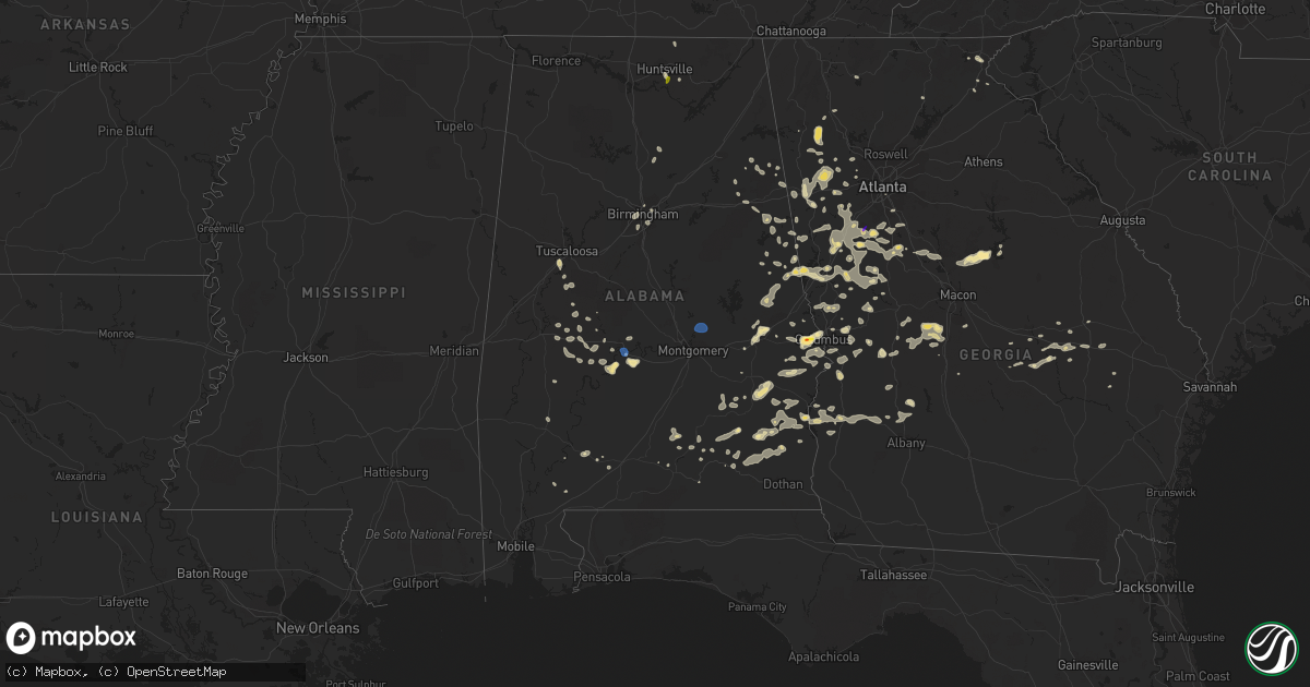
Hail Map in Alabama on June 15, 2022
Get this storm
June 15 map
$229
one time, instant access
Download today. No call, no setup
Keep the $229
Bought the map and want the full workflow? Apply the entire $229 to a subscription within 7 days. None of it is wasted.
Every map, not just this one
This buys you this map. Subscription and you get every map we run, in the markets you choose from a few cities to whole states to nationwide. Plus real-time alerts the moment a storm fires.
Contact data
Name, contact info, occupancy, even credit band for addresses in the footprint. You go from where it hit to who to call.
Become the source they trust
Unlimited branding weather history reports on demand. You already have the documented answer ready for the property owner, and you are the one who showed up with it.
Property data and RoofTrace estimates
Pull up any address you have got, its value and the exact code rules for that jurisdiction, straight from One Click Code. Then RoofTrace estimates the squares, pitch, and roof value, priced the way you price.
Storm reports in Alabama
Alabama
| Date | Description |
|---|---|
| 06/15/20226:59 PM CDT | Spotter reported golf ball sized hail along hwy 80 near crawford. |
| 06/15/20226:44 PM CDT | Trees and powerlines blown down. |
| 06/15/20226:43 PM CDT | Hail up to quarter size reported via social media. A few trees reported down in the same area. |
| 06/15/20225:43 PM CDT | Corrects previous hail report from 6 s eufaula country club. Hail up to quarter size reported via social media. A few trees reported down in the same area. |
| 06/15/20225:40 PM CDT | A few trees were blown down near us highway 80. |
| 06/15/20224:20 PM CDT | Dime to quarter size hail reported on charlotte drive in south huntsville. Report relayed via social media. |
| 06/15/20224:15 PM CDT | Corrects previous non-tstm wnd gst report from craig field airport. Awos station ksem selma craig fld. |
| 06/15/20224:15 PM CDT | Tree down at the intersection of carl t. Jones and garth road. Time estimated by radar. |
| 06/15/20224:11 PM CDT | Tree and power line damage along marsheutz avenue in huntsville. |
| 06/15/20224:11 PM CDT | Tree down and some powerlines down near huntsville hospital. Time estimated via radar. |
| 06/15/20224:09 PM CDT | Reports of pea to quarter size hail south of huntsville... Report relayed via social media. |
| 06/15/202210:06 AM CDT | A few trees blown down around clanton. |
| 06/15/20229:40 AM CDT | A few trees blown down around troy. |
| 06/15/20225:00 AM CDT | At 959 PM CDT, severe thunderstorms were located along a line extending from near Thorsby to near White Hall to near Logan, moving west at 40 mph. HAZARD...60 mph wind gusts. SOURCE...Radar indicated. IMPACT...Expect damage to roofs, siding, and trees. Locations impacted include... Selma, Clanton, Valley Grande, Marion, Uniontown, Mosses, Selmont-West Selmont, Maplesville, Gordonville, Orrville, Newbern, Benton, Bogue Chitto, Vaiden, Parnell, Tyler, Dannelly Reservoir, Mulberry, Paul M Grist State Park and Dallas Lake. |
| 06/15/20224:56 AM CDT | At 956 PM CDT, a severe thunderstorm was located near Sardis City, or 8 miles east of Boaz, moving northwest at 30 mph. HAZARD...60 mph wind gusts. SOURCE...Radar indicated. IMPACT...Expect damage to roofs, siding, and trees. Locations impacted include... Albertville, Scottsboro, Boaz, Guntersville, Arab, Rainsville, Crossville, Fyffe, Hollywood and Powell. |
| 06/15/20224:53 AM CDT | At 952 PM CDT, a severe thunderstorm was located near Monroeville, moving southwest at 20 mph. HAZARD...60 mph wind gusts and penny size hail. SOURCE...Radar indicated. IMPACT...Expect damage to roofs, siding, and trees. Locations impacted include... Monroeville, Frisco City, Uriah and Excel. |
| 06/15/20224:46 AM CDT | At 946 PM CDT, severe thunderstorms were located along a line extending from 11 miles southwest of Rutledge to 12 miles north of Gantt to 3 miles northwest of Dozier to Opp, moving southwest at 20 mph. HAZARD...60 mph wind gusts and penny size hail. SOURCE...Radar indicated. IMPACT...Expect damage to roofs, siding, and trees. Locations impacted include... Andalusia, Opp, McKenzie, River Falls, Red Level, Dozier, Heath and Gantt. |
| 06/15/20224:26 AM CDT | At 926 PM EDT, a severe thunderstorm was located near Felton, or near Buchanan, moving northwest at 10 mph. HAZARD...60 mph wind gusts and quarter size hail. SOURCE...Radar indicated. IMPACT...Hail damage to vehicles is expected. Expect wind damage to roofs, siding, and trees. Locations impacted include... Tallapoosa, Felton, Antioch and Esom Hill. |
| 06/15/20224:19 AM CDT | At 918 PM CDT, severe thunderstorms were located along a line extending from near Speed to Pike Road to near Linwood, moving west at 25 mph. HAZARD...60 mph wind gusts. Trees have been knoced down with this line of storms. SOURCE...Emergency management. IMPACT...Expect damage to roofs, siding, and trees. Locations impacted include... Montgomery, Prattville, Troy, Millbrook, Wetumpka, Fort Deposit, Mosses, Hayneville, Meadville, Pike Road, Elmore, Coosada, Deatsville, Autaugaville, White Hall, Gordonville, Billingsley, Lowndesboro, Hyundai Motors Of Alabama and Santuck. |
| 06/15/20224:06 AM CDT | At 906 PM CDT, severe thunderstorms were located along a line extending from near Ball Flat to near Bynum, moving west at 35 mph. HAZARD...60 mph wind gusts. SOURCE...Radar indicated. IMPACT...Expect damage to roofs, siding, and trees. Locations impacted include... Gadsden, Rainbow City, Attalla, Hokes Bluff, Springville, Glencoe, Ashville, Sardis City, Ragland, Steele, Altoona, Walnut Grove, Reece City, Tabor Road, Aurora, Ballplay, Gadsden Mall, Noccalula Falls, Neely Henry Lake and Southside. |
| 06/15/20223:42 AM CDT | At 842 PM CDT, severe thunderstorms were located along a line extending from 7 miles south of Rome to 6 miles southeast of Piedmont, moving northwest at 30 mph. HAZARD...60 mph wind gusts. SOURCE...Radar indicated. IMPACT...Expect damage to roofs, siding, and trees. Locations impacted include... Centre, Cedar Bluff, Little River Canyon National Preserve, Forney, Centre Municipal Airport, Leesburg, Sand Rock, Gaylesville, Tennala, Cherokee Rock Village, Pleasant Gap, Cornwall Furnace Park, Blanche, Eastern Weiss Lake, Little River Falls, Slackland, Western Weiss Lake, Moshat, Ball Flat and Coloma. |
| 06/15/20223:33 AM CDT | At 833 PM CDT, severe thunderstorms were located along a line extending from Mars Hills to 6 miles north of Delta, moving west at 15 mph. HAZARD...60 mph wind gusts. SOURCE...Radar indicated. IMPACT...Expect damage to roofs, siding, and trees. Locations impacted include... Anniston, Oxford, Jacksonville, Piedmont, Cobb Town, West End-Cobb Town, Fort McClellan, Saks, Glencoe, Weaver, Ohatchee, Hobson City, Blue Mountain, Alexandria, Jacksonville State University, Oxford Lake, Bynum, Neely Henry Lake, Southside and Choccolocco. |
| 06/15/20223:30 AM CDT | At 830 PM CDT, severe thunderstorms were located along a line extending from 6 miles northeast of Liberty City to Tuskegee, moving west at 15 mph. HAZARD...60 mph wind gusts and quarter size hail. SOURCE...Radar indicated. IMPACT...Hail damage to vehicles is expected. Expect wind damage to roofs, siding, and trees. Locations impacted include... Tuskegee, Tallassee, Notasulga, Milstead, Eclectic, Shorter, Franklin, Martin Dam, Reeves Airport, Lake Tuskegee, Davisville, Southern Lake Martin, Liverpool, Liberty City, Tallapoosa City, Tysonville, Victoryland, Kowaliga Bridge, Still Waters Resort and Western Lake Martin. |
| 06/15/20223:24 AM CDT | At 824 PM EDT, a severe thunderstorm was located over Dawson, moving west at 15 mph. HAZARD...60 mph wind gusts. SOURCE...Radar indicated. IMPACT...Expect damage to roofs, siding, and trees. Locations impacted include... Fort Gaines, Dawson, Cuthbert, Georgetown, Shellman, Wire Bridge, Walter F George Lake, Bonapartes Retreat, Standleys Store, Carnegie, Watson Crossroads, Crossroads, Ricks Place, Pecan, Randolph Co A/p, Dawson Municipal A/P, Aycock Mill, Hatcher, Morris and Jones Crossing. |
| 06/15/20223:23 AM CDT | At 823 PM CDT, severe thunderstorms were located along a line extending from near Spring Hill to Pickett, moving west at 15 mph. HAZARD...60 mph wind gusts and quarter size hail. SOURCE...Radar indicated. IMPACT...Hail damage to vehicles is expected. Expect wind damage to roofs, siding, and trees. Locations impacted include... Union Springs, Midway, Pickett, Aberfoil, Spring Hill, Comer, Barbour County Public Lake Dam, Beans Crossroads, Three Notch, Batesville, Perote and Mount Andrew. |
| 06/15/20223:13 AM CDT | At 813 PM CDT, severe thunderstorms were located along a line extending from 6 miles southwest of Rockmart to Ranburne, moving west at 15 mph. HAZARD...60 mph wind gusts. SOURCE...Radar indicated. IMPACT...Expect damage to roofs, siding, and trees. Locations impacted include... Heflin, Ranburne, Fruithurst, Edwardsville, Muscadine, Abernathy, Mars Hills, Mount Cheaha, Hollis Crossroads, Sweetwater Lake, Coleman Lake And Campground, Trickem, Lake Cleburne, I 20 Welcome Center, Liberty Hill, Chalafinnee, Oak Level, Borden Springs and Camp Sequoyah. |
| 06/15/20223:10 AM CDT | At 810 PM CDT, severe thunderstorms were located along a line extending from Corinth to near Wadley, moving west at 20 mph. HAZARD...60 mph wind gusts. SOURCE...Radar indicated. IMPACT...Expect damage to roofs, siding, and trees. Locations impacted include... Lineville, Ashland, Lake Wedowee, Woodland, Morrison Cross Roads, Barfield, Fosters Cross Roads, Delta, Corinth, Cleveland Crossroads, Cragford, R.L. Harris Dam, Ofelia, Motley, Lake Chinnabee, Millerville, Mellow Valley and Gunthertown. |
| 06/15/20223:09 AM CDT | At 809 PM CDT, a severe thunderstorm was located near Ozark, moving west at 20 mph. HAZARD...60 mph wind gusts. SOURCE...Radar indicated. IMPACT...Expect damage to roofs, siding, and trees. Locations impacted include... Daleville, Elba, Enterprise, Fort Rucker, Ozark, Level Plains, Newton, New Brockton, Ariton, Pinckard, Lee, Kinston, Mixons Crossroads, Hunt Field, Waterford, Curtis, Carl Folsom A/p, Hooper Stage Field, Gerald and Camp Humming Hills. |
| 06/15/20223:07 AM CDT | At 807 PM EDT, a severe thunderstorm was located over Cannonville, or near LaGrange, moving west at 35 mph. HAZARD...60 mph wind gusts and quarter size hail. SOURCE...Radar indicated. IMPACT...Hail damage to vehicles is expected. Expect wind damage to roofs, siding, and trees. Locations impacted include... LaGrange, West Point, Southern Harbor, Cannonville, State Line Park, Abbottsford, Rocky Point, Piedmont Heights, Wares Crossroads, Baughs Crossroads, Smiths Crossroad, Long Cane and Jones Crossroads. |
| 06/15/20223:07 AM CDT | At 807 PM CDT, severe thunderstorms were located along a line extending from near Griffen Mill to 6 miles north of Spring Hill, moving west at 15 mph. HAZARD...60 mph wind gusts. SOURCE...Radar indicated. IMPACT...Expect damage to roofs, siding, and trees. Locations impacted include... Tuskegee, Union Springs, Hurtsboro, Russell County Sports Complex, Uchee, Seale, Lake Tuskegee, Guerryton, Ladonia, Davisville, Society Hill, Griffen Mill, Warriorstand, Sedgefield, Fort Davis, Creek Stand, Rutherford, Monterey Heights, Hatchechubbe and Ladonia Sports Complex. |
| 06/15/20223:02 AM CDT | At 802 PM CDT, a severe thunderstorm was located near Tuskegee National Forest, or near Auburn, moving west at 20 mph. HAZARD...60 mph wind gusts and quarter size hail. SOURCE...Radar indicated. IMPACT...Hail damage to vehicles is expected. Expect wind damage to roofs, siding, and trees. Locations impacted include... Auburn, Tuskegee, Tallassee, Notasulga, Franklin, Waverly, Martin Dam, Liberty City, Reeves Airport, Auburn University, Tallapoosa City, Tuskegee National Forest, Southern Lake Martin, Loachapoka, Yates Dam, I 85 Rest Area, Uphapee Creek, Chewacla State Park, Roxana and Reeltown. |
| 06/15/20222:51 AM CDT | At 750 PM CDT, a severe thunderstorm was located over Brundidge, moving west at 15 mph. HAZARD...60 mph wind gusts and quarter size hail. SOURCE...Radar indicated. IMPACT...Hail damage to vehicles is expected. Expect wind damage to roofs, siding, and trees. Locations impacted include... Troy, Brundidge, Goshen, Antioch, Tennille, Tarentum, Brundidge Municipal Airport, Hamilton Crossroads, Springhill, Mossy Grove and Henderson. |
| 06/15/20222:45 AM CDT | At 745 PM CDT, a severe thunderstorm was located near Shelton State Community College, or 9 miles southwest of Tuscaloosa, and is nearly stationary. HAZARD...60 mph wind gusts and quarter size hail. SOURCE...Radar indicated. IMPACT...Hail damage to vehicles is expected. Expect wind damage to roofs, siding, and trees. Locations impacted include... Southwestern Tuscaloosa, Northport, Shelton State Community College, Tuscaloosa Amphitheater, Tuscaloosa Regional Airport, Englewood, Little Sandy, Maxwell, Taylorville, Fosters Boat Landing, Hull, Palmore Park, Stillman College, Fosters, Romulus and Oliver Lock And Dam. |
| 06/15/20222:36 AM CDT | At 736 PM CDT, severe thunderstorms were located along a line extending from Abanda to Waverly, moving west at 20 mph. HAZARD...60 mph wind gusts and penny size hail. SOURCE...Radar indicated. IMPACT...Expect damage to roofs, siding, and trees. Locations impacted include... Alexander City, Dadeville, Camp Hill, Jacksons' Gap, New Site, Waverly, Goldville, Hillabee Creek, Eastern Lake Martin, Western Lake Martin, Northern Lake Martin, Wind Creek State Park, Still Waters Resort, Southern Lake Martin, Daviston, Susannah Crossing, Maxwell Gunter Recreation Area, Blue Creek Marina, Horseshoe Bend National Military Park and Hackneyville. |
| 06/15/20222:21 AM CDT | At 720 PM CDT, a severe thunderstorm was located over Abbeville, moving west at 15 mph. HAZARD...60 mph wind gusts. SOURCE...Radar indicated. IMPACT...Expect damage to roofs, siding, and trees. Locations impacted include... Abbeville, Fort Rucker, Ozark, Enterprise, New Brockton, Ariton, Newville, Haleburg, Mixons Crossroads, Hooper Stage Field, Camp Humming Hills, Clintonville, Ewell, Roeton, Dale County Lake, Camp Alaflo Bsa, Phillips Crossroads, Arcus, Hwy 231 Pea River Bridge and Balkum. |
| 06/15/20222:20 AM CDT | At 720 PM CDT, a severe thunderstorm was located 7 miles southeast of Moundville, or 17 miles north of Greensboro, and is nearly stationary. HAZARD...60 mph wind gusts and quarter size hail. SOURCE...Radar indicated. IMPACT...Hail damage to vehicles is expected. Expect wind damage to roofs, siding, and trees. Locations impacted include... Moundville, Mound State Park, Elliots Creek, Wateroak, Moundville Airport, Phipps, Havana, Hull and Harper Hill. |
| 06/15/20222:12 AM CDT | At 712 PM CDT, a severe thunderstorm was located over Tyler Crossroads, or near Clio, moving west at 20 mph. HAZARD...60 mph wind gusts and quarter size hail. SOURCE...Radar indicated. IMPACT...Hail damage to vehicles is expected. Expect wind damage to roofs, siding, and trees. Locations impacted include... Clio, Louisville, Blue Springs, Tyler Crossroads, Doster and Blue Springs State Park. |
| 06/15/20221:48 AM CDT | At 648 PM EDT, a severe thunderstorm was located near Hamilton, moving southwest at 20 mph. HAZARD...60 mph wind gusts and quarter size hail. SOURCE...Radar indicated. IMPACT...Hail damage to vehicles is expected. Expect wind damage to roofs, siding, and trees. Locations impacted include... Columbus, Hamilton, Bibb City, Upatoi, Goat Rock Lake, Ellerslie, Saint Marys Hills, Edgewood, Flat Rock, Highland Park, Laurel Hills, Green Island Hills, Vista Terrace, Cataula, Columbus Metropolitan Airport, Rose Hill, Midland, Kenwood, Mountain Hill and Avondale. |
| 06/15/20221:07 AM CDT | At 606 PM CDT, a severe thunderstorm was located over western Birmingham, and is nearly stationary. HAZARD...60 mph wind gusts and penny size hail. SOURCE...Radar indicated. IMPACT...Expect damage to roofs, siding, and trees. Locations impacted include... Birmingham, Hoover, Vestavia Hills, Bessemer, Homewood, Mountain Brook, Hueytown, Irondale, Fairfield, Pleasant Grove, Midfield, Adamsville, Brighton, Lipscomb, Sylvan Springs, Mulga, Birmingham Fairgounds, B.j.c.c., Edgewater and Kingston. |
| 06/15/202212:20 AM CDT | At 520 PM CDT, severe thunderstorms were located along a line extending from Marion Junction to Dannelly Reservoir, moving west at 10 mph. HAZARD...60 mph wind gusts. SOURCE...Radar indicated. IMPACT...Expect damage to roofs, siding, and trees. Locations impacted include... Uniontown, Orrville, Bogue Chitto, Dannelly Reservoir, Marion Junction, Central Mills, Perry County Correctional Center, Crumptonia and Safford. |
| 06/15/202212:07 AM CDT | At 507 PM CDT, a severe thunderstorm was located near Blountsville, and is nearly stationary. HAZARD...60 mph wind gusts. SOURCE...Radar indicated. IMPACT...Expect damage to roofs, siding, and trees. Locations impacted include... Holly Pond and Walter. |
| 06/15/202212:04 AM CDT | At 504 PM CDT, a severe thunderstorm was located over Blountsville, and is nearly stationary. HAZARD...60 mph wind gusts. SOURCE...Radar indicated. IMPACT...Expect damage to roofs, siding, and trees. Locations impacted include... Blountsville, Cleveland, Nectar, Fowler Spring and Chamblees Mill. |
| 06/14/202211:45 PM CDT | At 444 PM CDT, severe thunderstorms were located along a line extending from near Potter Station to near Dallas Lake, and are nearly stationary. HAZARD...60 mph wind gusts. SOURCE...Radar indicated. IMPACT...Expect damage to roofs, siding, and trees. Locations impacted include... Selma, Orrville, Belknap, Bogue Chitto, Dallas Lake, Dannelly Reservoir, Marion Junction, Dallas County Horse Arena, Potter Station, Memorial Stadium, Skyharbor Airport, Whites Bluff, Hazen and Crumptonia. |
| 06/14/202211:45 PM CDT | At 445 PM CDT, a severe thunderstorm was located near Redstone Arsenal, moving north at 10 mph. HAZARD...60 mph wind gusts and quarter size hail. SOURCE...Radar indicated. IMPACT...Hail damage to vehicles is expected. Expect wind damage to roofs, siding, and trees. Locations impacted include... Huntsville, Redstone Arsenal, University Of Alabama In Huntsville and Farley. |
| 06/14/202211:22 PM CDT | At 422 PM CDT, a severe thunderstorm was located over Tyler, or 9 miles southeast of Selmont-West Selmont, moving southwest at 5 mph. HAZARD...60 mph wind gusts and penny size hail. SOURCE...Radar indicated. IMPACT...Expect damage to roofs, siding, and trees. Locations impacted include... Selma, Selmont-West Selmont, White Hall, Benton, Old Cahaba Park, Tyler, Selma Drag Strip, Collirene, Edmund Pettus Bridge and Craig Field Aiport. |
| 06/14/202210:56 PM CDT | At 356 PM CDT, a severe thunderstorm was located over southeastern Huntsville, moving north at 10 mph. HAZARD...60 mph wind gusts and quarter size hail. SOURCE...Radar indicated. IMPACT...Hail damage to vehicles is expected. Expect wind damage to roofs, siding, and trees. Locations impacted include... Huntsville, Madison, Moores Mill, Redstone Arsenal, Meridianville, Alabama A And M University, University Of Alabama In Huntsville and Hampton Cove. |
| 06/14/202210:07 PM CDT | A few trees were blown down. |
| 06/14/202210:06 PM CDT | Corrects previous tstm wnd dmg report from clanton. A few trees blown down around clanton. |
| 06/14/20229:53 PM CDT | Report of multiple trees down in the arab vicinity. Time estimated based on radar. |
| 06/14/20229:43 PM CDT | Trees were blown down outside gallant. |
| 06/14/20229:40 PM CDT | Numerous trees were blown down around ashland. Some of these trees blocked roadways and a few landed on vehicles. |
| 06/14/20229:40 PM CDT | Trees down in ashland. |
| 06/14/20229:40 PM CDT | Corrects previous tstm wnd dmg report from troy. A few trees blown down around troy. |
| 06/14/20229:37 PM CDT | Several trees and power lines were blown down around steele. |
| 06/14/20229:37 PM CDT | Broadcast media relayed pictures of two uprooted pecan trees in the boaz area. Time estimated based on radar. |
| 06/14/20229:32 PM CDT | A couple of trees blown down around pell city. |
| 06/14/20229:32 PM CDT | Trees down in ragland. |
| 06/14/20229:32 PM CDT | Several trees and powerlines were blown down. Dispatch received at least 8 calls of damage. |
| 06/14/20229:32 PM CDT | Several trees and powerlines down. |
| 06/14/20229:32 PM CDT | Numerous reports of trees down across etowah county. Several have fallen on homes. Details pending. |
| 06/14/20229:30 PM CDT | Trees and power lines down. |
| 06/14/20229:27 PM CDT | Several trees down... Power outages. |
| 06/14/20229:16 PM CDT | Numerous trees and power lines were blown down around wetumpka. The city received at least 24 calls of damage. |
| 06/14/20229:16 PM CDT | Trees and power lines down around wetumpka. |
| 06/14/20229:15 PM CDT | Multiple trees down in and around ohatchee. |
| 06/14/20229:05 PM CDT | Trees blown down across southern portions of the county. |
| 06/14/20229:05 PM CDT | Trees blown down... Power outages. |
| 06/14/20229:03 PM CDT | Trees and power lines down. |
| 06/14/20229:01 PM CDT | One tree down on forest lake drive. |
| 06/14/20229:00 PM CDT | Multiple trees down in and around the city of anniston. |
| 06/14/20228:55 PM CDT | Several trees blown down... Power outages. |
| 06/14/20228:55 PM CDT | Corrects previous tstm wnd dmg report from 6 n choccolocco. Trees blown down... Numerous power outages reported. |
| 06/14/20228:55 PM CDT | Several trees and power lines were blown down around tallassee. The city received at least 9 calls of damage. |
| 06/14/20228:50 PM CDT | Several trees down on st francis rd with power outages reported overnight. Additional trees were downed in the historic district in eufaula on us 431. |
| 06/14/20228:44 PM CDT | Kanb measured 44 mph wind gust along outflow. |
| 06/14/20228:40 PM CDT | One tree down. |
| 06/14/20228:39 PM CDT | Trees blown down. |
| 06/14/20228:35 PM CDT | Multiple trees down along county road 308. |
| 06/14/20228:30 PM CDT | Numerous trees and power lines reported down... Mainly across the southern half of cleburne county. The most widespread tree damage was reported in micaville and ranbur |
| 06/14/20228:27 PM CDT | Several trees blown down... Power outages. |
| 06/14/20228:15 PM CDT | Trees blown down... Power outages. |
| 06/14/20228:15 PM CDT | Several reports of trees blown down. |
| 06/14/20228:13 PM CDT | One tree down at east 27 and east 36. |
| 06/14/20228:04 PM CDT | Reported on social media. |
| 06/14/20228:03 PM CDT | Trees blown down. |
| 06/14/20227:55 PM CDT | One tree down on hwy 54. |
| 06/14/20227:55 PM CDT | Trees blown down... Numerous power outages reported. |
| 06/14/20227:52 PM CDT | Several trees blown down. |
| 06/14/20227:28 PM CDT | Several trees down north of moundville. Winds estimated at 50-60 mph. |
| 06/14/20227:06 PM CDT | Trees blown down near lee rd 2089. |
All States Impacted by Hail Map on June 15, 2022
Cities Impacted by Hail Map on June 15, 2022
- Harmony, MN
- Scipio Center, NY
- Rib Lake, WI
- Medford, WI
- Wautoma, WI
- Neshkoro, WI
- Montello, WI
- Westfield, WI
- Oxford, WI
- Grand Marsh, WI
- Cottage Grove, WI
- Stoughton, WI
- Ishpeming, MI
- Champion, MI
- Theresa, WI
- Viroqua, WI
- Mayville, WI
- Lomira, WI
- Traverse City, MI
- Manchester, IA
- Greeley, IA
- La Valle, WI
- Nunda, NY
- Mount Morris, NY
- Piedmont, AL
- Birmingham, AL
- Tampico, IL
- Prophetstown, IL
- Rock Falls, IL
- Merrill, WI
- Brokaw, WI
- Wausau, WI
- Cascade, WI
- Plymouth, WI
- Sheboygan Falls, WI
- Waldo, WI
- Lanesboro, MN
- Preston, MN
- Chatham, MI
- Trenary, MI
- Twin Lake, MI
- Muskegon, MI
- Eckerman, MI
- Fayette, IA
- Mcfarland, WI
- Bristol, WI
- Kenosha, WI
- Heflin, AL
- Wedowee, AL
- Gowen, MI
- Trufant, MI
- Readstown, WI
- Viola, WI
- Dodgeville, WI
- Blue Mounds, WI
- Mount Horeb, WI
- Salem, IA
- Merrimac, WI
- Lodi, WI
- Portage, WI
- Pardeeville, WI
- North Freedom, WI
- Plain, WI
- Prairie Du Sac, WI
- Baraboo, WI
- Sauk City, WI
- Delta, AL
- Morrison, IL
- Fenton, IL
- Deerbrook, WI
- Two Rivers, WI
- Manitowoc, WI
- Eureka, IL
- Lima, NY
- Bellevue, IA
- Geneva, NY
- Romulus, NY
- Pearl City, IL
- Tiger, GA
- Cedartown, GA
- Rockmart, GA
- Aragon, GA
- Sumner, IA
- Antigo, WI
- Newberry, MI
- Paradise, MI
- Grawn, MI
- Wonewoc, WI
- Wisconsin Dells, WI
- Mauston, WI
- Hillsboro, WI
- Lyndon Station, WI
- Friendship, WI
- Adams, WI
- Kendall, WI
- Elroy, WI
- La Farge, WI
- Hermansville, MI
- Spalding, MI
- Escanaba, MI
- Wilson, MI
- Wells, MI
- Manistique, MI
- Bark River, MI
- Daggett, MI
- Wausaukee, WI
- Stephenson, MI
- Amberg, WI
- Wetmore, MI
- Cornell, MI
- Powers, MI
- Rapid River, MI
- Nahma, MI
- Carney, MI
- Gladstone, MI
- Nadeau, MI
- Vulcan, MI
- Weyauwega, WI
- Waupaca, WI
- Wild Rose, WI
- Pine River, WI
- Watertown, WI
- Blue River, WI
- Fennimore, WI
- Stitzer, WI
- Muscoda, WI
- Montfort, WI
- Avoca, WI
- Highland, WI
- Richland Center, WI
- Lone Rock, WI
- Mount Hope, WI
- Woodman, WI
- Boscobel, WI
- Lancaster, WI
- Bruce, WI
- Holcombe, WI
- Wilton, WI
- Tomah, WI
- Garnavillo, IA
- Patch Grove, WI
- Glen Haven, WI
- Guttenberg, IA
- Bloomington, WI
- Prairie Du Chien, WI
- Bagley, WI
- Gurley, AL
- Owens Cross Roads, AL
- Gays Mills, WI
- Anamosa, IA
- Monticello, IA
- Sterling, IL
- Novinger, MO
- Green Castle, MO
- Milan, MO
- Green City, MO
- Anniston, AL
- Disputanta, VA
- Petersburg, VA
- Mouth Of Wilson, VA
- Highlands, NC
- Maquoketa, IA
- Kent, IL
- Blountsville, AL
- Leaf River, IL
- Winnebago, IL
- Shannon, IL
- Lanark, IL
- Mount Carroll, IL
- Hudson, IN
- Wolcottville, IN
- Angola, IN
- Lagrange, IN
- Alexandria, AL
- Jacksonville, AL
- Wellington, AL
- Franklin, GA
- Marion, NC
- Hollister, NC
- Littleton, NC
- Lake Como, PA
- Starlight, PA
- Hankins, NY
- Callicoon, NY
- Long Eddy, NY
- Preston Park, PA
- Starrucca, PA
- Hancock, NY
- Lakewood, PA
- Damascus, PA
- Equinunk, PA
- Unionville, MO
- Worthington, MO
- Polo, MO
- Lathrop, MO
- Turney, MO
- Freeport, IL
- Ridott, IL
- Reidsville, GA
- Elba, AL
- Gainestown, AL
- Toccoa, GA
- Adrian, GA
- Swainsboro, GA
- Troy, AL
- Hamilton, GA
- Pine Mountain, GA
- Shiloh, GA
- Pine Mountain Valley, GA
- Lowell, WI
- Waterloo, WI
- Juneau, WI
- Marshall, WI
- Rio, WI
- Madison, WI
- Columbus, WI
- Waunakee, WI
- Deforest, WI
- Windsor, WI
- Reeseville, WI
- Beaver Dam, WI
- Sun Prairie, WI
- West Liberty, IA
- West Branch, IA
- Atalissa, IA
- Riverside, IA
- Hampton, GA
- Ozark, AL
- Midland City, AL
- Fort Rucker, AL
- Skipperville, AL
- Newville, AL
- Taylorsville, GA
- Kingston, GA
- Rome, GA
- Silver Creek, GA
- Faunsdale, AL
- Thomaston, GA
- Pittsview, AL
- Eufaula, AL
- Hurtsboro, AL
- Hatchechubbee, AL
- Dexter, GA
- Safford, AL
- Orrville, AL
- Brownsville, MN
- Box Springs, GA
- Glenwood, GA
- Red Level, AL
- Sparta, GA
- Milledgeville, GA
- West Point, GA
- Cataula, GA
- Dawson, GA
- Bronwood, GA
- Phenix City, AL
- Alma, MI
- Elwell, MI
- Saint Louis, MI
- Shepherd, MI
- Eastman, GA
- Tyler, AL
- Selma, AL
- Abbeville, AL
- Clopton, AL
- Clayton, AL
- Louisville, AL
- Notasulga, AL
- Auburn, AL
- La Crescent, MN
- Tipton, IA
- Concord, GA
- East Dublin, GA
- Waco, GA
- Bremen, GA
- Carrollton, GA
- Hartford, KS
- Olpe, KS
- Fort Valley, GA
- Downing, MO
- Lancaster, MO
- Cantril, IA
- Donnellson, IA
- Pulaski, IA
- Bloomfield, IA
- Farmington, IA
- Milton, IA
- Bonaparte, IA
- Memphis, MO
- Mount Sterling, IA
- Keosauqua, IA
- Cuthbert, GA
- Morris, GA
- Brantley, AL
- Luverne, AL
- Grantville, GA
- Brundidge, AL
- Washington, IA
- Ainsworth, IA
- Elma, IA
- Five Points, AL
- Lagrange, GA
- Ideal, GA
- Marshallville, GA
- Perry, GA
- Oglethorpe, GA
- Reynolds, GA
- Leslie, GA
- Smithville, GA
- Cascade, IA
- Worthington, IA
- Farley, IA
- Wapello, IA
- Mount Pleasant, IA
- Winfield, IA
- Morning Sun, IA
- Wayland, IA
- Oakville, IA
- Mediapolis, IA
- Olds, IA
- Yarmouth, IA
- Mount Union, IA
- Queen City, MO
- Roanoke Rapids, NC
- Bowdon, GA
- Dozier, AL
- Griffin, GA
- Fayetteville, GA
- Brooks, GA
- Mossville, IL
- Benson, IL
- Roanoke, IL
- Metamora, IL
- Peoria, IL
- Lowpoint, IL
- Princeville, IL
- Dunlap, IL
- Washburn, IL
- Flanagan, IL
- Minonk, IL
- Peoria Heights, IL
- El Paso, IL
- Edwards, IL
- Washington, IL
- Brimfield, IL
- East Peoria, IL
- Chillicothe, IL
- Poynette, WI
- Randolph, WI
- Arlington, WI
- Doylestown, WI
- Fall River, WI
- Morrisonville, WI
- Adairsville, GA
- Eatonton, GA
- Huntsville, AL
- Smiths Station, AL
- Camp Douglas, WI
- Warrens, WI
- Banks, AL
- Warm Springs, GA
- Lumpkin, GA
- Omaha, GA
- Cadwell, GA
- Shellman, GA
- Georgetown, GA
- Fort Gaines, GA
- Dublin, GA
- Luthersville, GA
- Clio, AL
- Hazleton, IA
- Dundee, IA
- Edgewood, IA
- Lamont, IA
- Winthrop, IA
- Independence, IA
- Strawberry Point, IA
- Aurora, IA
- Stanley, IA
- Lakemont, GA
- Buena Vista, GA
- Ellaville, GA
- Newnan, GA
- Woodland, AL
- Madison, KS
- Springville, IA
- Central City, IA
- Muscatine, IA
- Elizabeth, IL
- Kingston, MO
- Ariton, AL
- Stockbridge, GA
- Jonesboro, GA
- Monroeville, AL
- Pinckney, MI
- Gregory, MI
- Jackson, MI
- Munith, MI
- Grass Lake, MI
- Whitmore Lake, MI
- Chelsea, MI
- Stockbridge, MI
- Dexter, MI
- Rives Junction, MI
- Pleasant Lake, MI
- Richmond, MO
- Marion, AL
- Repton, AL
- Port Charlotte, FL
- Johnson Creek, WI
- Lake Mills, WI
- Jefferson, WI
- Davenport, IA
- Blue Grass, IA
- Bettendorf, IA
- Woodbury, GA
- Molena, GA
- Leesburg, GA
- Orland, IN
- Fremont, IN
- Lawrence, KS
- Salem, AL
- Seale, AL
- Sperry, IA
- Hogansville, GA
- Palmetto, GA
- Lanett, AL
- Douglasville, GA
- Moreland, GA
- Zebulon, GA
- Lafayette, AL
- Williamson, GA
- Manchester, GA
- Senoia, GA
- Whitesburg, GA
- Milner, GA
- Greenville, GA
- Peachtree City, GA
- Fairburn, GA
- Sharpsburg, GA
- Gay, GA
- Meansville, GA
- Buchanan, GA
- Dallas, GA
- Temple, GA
- Villa Rica, GA
- Osage City, KS
- Durant, IA
- Crawfordsville, IA
- Donahue, IA
- Wilton, IA
- Columbus Junction, IA
- Dixon, IA
- Letts, IA
- Nichols, IA
- Eldridge, IA
- Walcott, IA
- Long Grove, IA
- Columbus City, IA
- Conesville, IA
- Stockton, IA
- Opelika, AL
- Gallion, AL
- Greensboro, AL
- Atmore, AL
- Columbus, GA
- Midland, GA
- Upatoi, GA
- Woodland, GA
- Fort Benning, GA
- Midway, AL
- Frisco City, AL
- Murphy, NC
- Marble, NC
- Charles City, IA
- Talbotton, GA
- Alamo, GA
- Sardis, AL
- Ithaca, NY
- Brooktondale, NY
- Tuskegee, AL
- Lost Nation, IA
- Grand Mound, IA
- Spragueville, IA
- Miles, IA
- Delmar, IA
- Charlotte, IA
- Wheatland, IA
- Preston, IA
- Congerville, IL
- Secor, IL
- Gridley, IL
- Haddock, GA
- Brighton, IA
- Lone Tree, IA
- Iowa City, IA
- Mcdonough, GA
- Hanover, IL
- Powder Springs, GA
- Minter, AL
- Iowa Falls, IA
- Warren, IL
- Apple River, IL
- Stockton, IL
- Fruithurst, AL
- East Bethany, NY
- Pavilion, NY
- Wyoming, NY
- Canton, MN
- Plattsburg, MO
- Marshall, MI
- Bellevue, MI
- Battle Creek, MI
- Smithville, MO
- Catawissa, PA
- Danville, PA
- Glenwood, AL
- Marion Junction, AL
- Coleman, GA
- Roanoke, AL
- Flovilla, GA
- Jackson, GA
- Forsyth, GA
- Livonia, NY
- Hemlock, NY
- Hayesville, NC
- Clarkdale, GA
- Austell, GA
- Kansas City, MO
- Platte City, MO
- Owego, NY
- Newark Valley, NY
- Endicott, NY
- Caledonia, MN
- Mechanicsville, VA
- Woodstock, IL
- Mount Airy, GA
- Pecatonica, IL
- Opp, AL
- Soperton, GA
- Tarrytown, GA
- Rockledge, GA
- Newbern, AL
- Fort Mitchell, AL
- Vidalia, GA
- Ellerslie, GA
- Thomasville, AL
- Grove Hill, AL
- Dickinson, AL
- Moundville, AL
- Wadley, AL
- Union Springs, AL
- King William, VA
- Savanna, IL
- Sabula, IA
- Warsaw, NY
- Humphreys, MO
- Galt, MO
- Laredo, MO
- Forreston, IL
- Chadwick, IL
- Milledgeville, IL
- Polo, IL
- Tuscaloosa, AL
- Fosters, AL
- Warner Robins, GA
- Cowgill, MO
- Braymer, MO
- Hamilton, MO
- Kahoka, MO
- Wyaconda, MO
- Rutledge, MO
- Greentop, MO
- Luray, MO
- Arbela, MO
- Saint Patrick, MO
- Gorin, MO
- Lyons, GA
- Hiram, GA
- Greenville, AL
- Acworth, GA
- Marietta, GA
- Kennesaw, GA
- Oxford, AL
- Magnolia, AL
- Pine Hill, AL
- Little River, AL
- Colwell, IA
- Cresco, IA
- Ridgeway, IA
- Lime Springs, IA
- Alta Vista, IA
- Orchard, IA
- New Hampton, IA
- Riceville, IA
- Elko, GA
- De Soto, WI
- Genoa, WI
- Spring Grove, MN
- Mabel, MN
- Decorah, IA
- Muscadine, AL
- Neosho, WI
- Ladysmith, WI
- Vestaburg, MI
- Lakeview, MI
- Riverdale, MI
- Stanton, MI
- Breckenridge, MI
- Edmore, MI
- New Market, AL
- Silver Springs, NY
- Helenville, WI
- Fort Atkinson, WI
- Cambridge, WI
- Camanche, IA
- Cordova, IL
- Collins, GA
- Tuskegee Institute, AL
- Goose Lake, IA
- Clinton, IA
- De Witt, IA
- Cayuta, NY
- Horseheads, NY
- Millport, NY
- Montour Falls, NY
- Newfield, NY
- Odessa, NY
- Alpine, NY
- Palmetto, FL
- Parrish, FL
- Wimauma, FL
- Ruskin, FL
- Bennett, IA
- Myakka City, FL
- Thomaston, AL
- Catherine, AL
- Uniontown, AL
- Butler, GA
- Metter, GA
- Ackley, IA
- Hampton, IA
- Coon Valley, WI
- Mauk, GA
- Ferryville, WI
- Winston, GA
- Emporia, KS
- Neosho Rapids, KS
- Leicester, NY
- Perry, NY
- Ontario, WI
- Dahlonega, GA
- Graham, AL
- Hanover, VA
- Manquin, VA
- Nebo, NC
- Kearney, MO
- Liberty, MO
- Jack, AL
- Cusseta, GA
- Sarasota, FL
- Union Springs, NY
- Aurora, NY
- Ovid, NY
- Norwalk, WI
- Harvard, IL
- Hebron, IL
- Erie, IL
- Albany, IL
- Tallapoosa, GA
- Stockport, IA
- Ionia, IA
- West Salem, WI
- Sparta, WI
- Little Cedar, IA
- Osage, IA
- Spring Valley, MN
- McIntire, IA
- Stoddard, WI
- Rockwell, IA
- Sheffield, IA
- Thornton, IA
- Le Roy, MN
- Wykoff, MN
- Rudd, IA
- Nora Springs, IA
- Mason City, IA
- La Crosse, WI
- Cashton, WI
- Swaledale, IA
- Rockford, IA
- Eitzen, MN
- Rockland, WI
- Floyd, IA
- Ostrander, MN
- Chester, IA
- Hokah, MN
- Bangor, WI
- Chaseburg, WI
- Necedah, WI
- Dorchester, IA
- Peterson, MN
- Rushford, MN
- Houston, MN
- Attica, NY
- Ellijay, GA
- Chatsworth, GA
- Atlanta, GA
- Enterprise, AL
- New Brockton, AL
- Bay City, MI
- Hillsboro, IA
- Birmingham, IA
- Waverly, AL
- Camp Hill, AL
- Grady, AL
- Glenwood, MO
- Coatsville, MO
- Ixonia, WI
- Oconomowoc, WI
- Edgerton, WI
- Sullivan, WI
- Ceresco, MI
- Castalia, NC
- Nashville, NC
- Clayton, GA
- Clarkesville, GA
- Hardaway, AL
- Waupun, WI
- Fox Lake, WI
- Burnett, WI
- Cambria, WI
- Dane, WI
- Clyman, WI
- Deerfield, WI
- Middleton, WI
- Verona, WI
- Horicon, WI
- Iron Ridge, WI
- Hustisford, WI
- Dansville, NY
- Bradenton, FL
- Monticello, GA
- Unadilla, GA
- Hawkinsville, GA
- Jesup, IA
- Hayden, AL
- Walton, NY
- Chillicothe, MO
- Fairfield, AL
- Saint Paul, IA
- West Point, IA
- Pollock, MO
- Livonia, MO
- Bostic, NC
- Chester, VA
- Chesterfield, VA
- Shullsburg, WI
- Darlington, WI
- Mineral Point, WI
- Berkshire, NY
- Wauzeka, WI
- New London, IA
- Hillsboro, GA
- Gray, GA
- Virgil, KS
- Hamilton, KS
- Eureka, KS
- Jones, AL
- Arlington, IA
- Fulton, IL
- Plains, GA
- Bradford, IA
- Lawler, IA
- Westby, WI
- Dakota, MN
- Elmore, AL
- Wetumpka, AL
- Manawa, WI
- Shiocton, WI
- Bonduel, WI
- Pulaski, WI
- Fremont, WI
- New London, WI
- Black Creek, WI
- Seymour, WI
- Wittenberg, WI
- Bowler, WI
- Tigerton, WI
- Crivitz, WI
- Oneida, WI
- New Lisbon, WI
- Redgranite, WI
- Appleton, WI
- Suamico, WI
- Brussels, WI
- Winneconne, WI
- Green Bay, WI
- Berlin, WI
- Sturgeon Bay, WI
- Hancock, WI
- Poy Sippi, WI
- Hortonville, WI
- Neenah, WI
- New Franken, WI
- Princeton, WI
- Greenville, WI
- Luxemburg, WI
- Kaukauna, WI
- De Pere, WI
- Coloma, WI
- Larsen, WI
- Stevens Point, WI
- Rudolph, WI
- Eland, WI
- Wisconsin Rapids, WI
- Hatley, WI
- Custer, WI
- Rosholt, WI
- Iola, WI
- Friesland, WI
- Wyocena, WI
- Amherst, WI
- Almond, WI
- Clintonville, WI
- Scandinavia, WI
- Oconto, WI
- Little Suamico, WI
- Krakow, WI
- Oconto Falls, WI
- Marinette, WI
- Sobieski, WI
- Abrams, WI
- Lena, WI
- Ogdensburg, WI
- Peshtigo, WI
- Bear Creek, WI
- Nichols, WI
- Fountain, MN
- Elkport, IA


