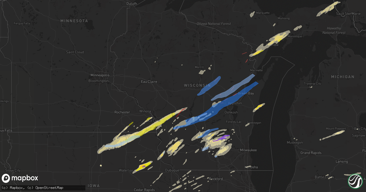
Hail Map in Wisconsin on June 15, 2022
Get this storm
June 15 map
$229
one time, instant access
Download today. No call, no setup
Keep the $229
Bought the map and want the full workflow? Apply the entire $229 to a subscription within 7 days. None of it is wasted.
Every map, not just this one
This buys you this map. Subscription and you get every map we run, in the markets you choose from a few cities to whole states to nationwide. Plus real-time alerts the moment a storm fires.
Contact data
Name, contact info, occupancy, even credit band for addresses in the footprint. You go from where it hit to who to call.
Become the source they trust
Unlimited branding weather history reports on demand. You already have the documented answer ready for the property owner, and you are the one who showed up with it.
Property data and RoofTrace estimates
Pull up any address you have got, its value and the exact code rules for that jurisdiction, straight from One Click Code. Then RoofTrace estimates the squares, pitch, and roof value, priced the way you price.
Storm reports in Wisconsin
Wisconsin
| Date | Description |
|---|---|
| 06/15/20226:59 PM CDT | Fire department report of multiple trees and power lines down near sturgeon bay and wi hwy 42. Time estimated from radar. |
| 06/15/20226:59 PM CDT | Multiple trees snapped in the city. |
| 06/15/20226:50 PM CDT | Reports of numerous trees and power lines down in the area. Time estimated on radar. |
| 06/15/20226:50 PM CDT | Reports of numerous trees and powerlines down in the area. Time estimated on radar. |
| 06/15/20226:50 PM CDT | Pine trees snapped and large limbs down. |
| 06/15/20226:45 PM CDT | Reports of numerous trees down in the beaver dam area. Time estimated on radar. |
| 06/15/20226:39 PM CDT | Report of trees down and collapsed roofs. Time and location estimated from radar. Delayed report. |
| 06/15/20226:39 PM CDT | 20 inch branches down. |
| 06/15/20226:31 PM CDT | Several trees down. A few roads were impassable due to the fallen trees. |
| 06/15/20226:30 PM CDT | Wind estimated around 60 mph. Trees and power lines down. |
| 06/15/20226:27 PM CDT | Multiple trees down on laredo lane. |
| 06/15/20226:25 PM CDT | A local report indicates 59 MPH wind near GREEN BAY |
| 06/15/20226:25 PM CDT | Trained spotter reported multiple 12 to 18 inch diameter trees down. Time estimated via radar. Delayed report. |
| 06/15/20226:25 PM CDT | Numerous trees down in the area. Time estimated on radar. |
| 06/15/20226:23 PM CDT | Trees and power lines down. |
| 06/15/20226:22 PM CDT | Trees and power lines down on lovers lane just south of markesan. |
| 06/15/20226:18 PM CDT | Multiple trees snapped in the city. |
| 06/15/20226:18 PM CDT | Barn reported down via emergency manager. |
| 06/15/20226:17 PM CDT | Trees uprooted or snapped. |
| 06/15/20226:17 PM CDT | Ef1 tornado. No injuries or fatalities. Time estimated off radar. |
| 06/15/20226:16 PM CDT | Trees and power lines down. |
| 06/15/20226:16 PM CDT | Powerlines down across the road and a shed partly damaged. |
| 06/15/20226:15 PM CDT | A local report indicates 59 MPH wind near APPLETON |
| 06/15/20226:14 PM CDT | Trees were snapped and power lines down. |
| 06/15/20226:14 PM CDT | Numerous trees down in the area. Time estimated on radar. |
| 06/15/20226:14 PM CDT | Observed tornado touched down in navarino. |
| 06/15/20226:14 PM CDT | Multiple trees snapped and power lines down. |
| 06/15/20226:12 PM CDT | Emergency manager reports numerous trees and power lines downed and blocking highways and roads between black creek and freedom. Time based on radar estimate. Delayed r |
| 06/15/20226:12 PM CDT | Trees uprooted or snapped. Roof was blown off. |
| 06/15/20226:11 PM CDT | Barn was reported down via emergency manager. |
| 06/15/20226:08 PM CDT | Trees down. |
| 06/15/20226:07 PM CDT | Tree limbs broken. |
| 06/15/20226:06 PM CDT | Report from mping: 3-inch tree limbs broken; power poles broken. |
| 06/15/20226:05 PM CDT | Trees down. |
| 06/15/20226:00 PM CDT | Social media report of winds causing roof damage as well a damage to a boat on swan lake. Time estimate based on radar. |
| 06/15/20225:59 PM CDT | Trees down. |
| 06/15/20225:59 PM CDT | Report from mping: trees uprooted or snapped; roof blown off. |
| 06/15/20225:56 PM CDT | Corrects previous tstm wnd dmg report from manawa. Trees down. |
| 06/15/20225:56 PM CDT | Trees down. |
| 06/15/20225:45 PM CDT | Report of multiple trees down on social media. Time estimated on radar. |
| 06/15/20225:44 PM CDT | Report from mping: 1-inch tree limbs broken; shingles blown off. |
| 06/15/20225:42 PM CDT | Trees down along highway 29. |
| 06/15/20225:41 PM CDT | Tree went through roof of house. Time estimated on radar. |
| 06/15/20225:41 PM CDT | Report from mping: 3-inch tree limbs broken; power poles broken. |
| 06/15/20225:41 PM CDT | Tree limbs down. |
| 06/15/20225:40 PM CDT | Trees and power lines down. |
| 06/15/20225:39 PM CDT | Tree and power lines down. |
| 06/15/20225:39 PM CDT | A local report indicates 70 MPH wind near REDGRANITE |
| 06/15/20225:37 PM CDT | Report from mping: 1-inch tree limbs broken; shingles blown off. |
| 06/15/20225:34 PM CDT | Multiple semis tipped over on i-90/94... Mostly in eastbound lane. |
| 06/15/20225:32 PM CDT | Reports of multiple trees down in communities from oxford to the north in marquette county. |
| 06/15/20225:32 PM CDT | Trees uprooted or snapped. A roof blown off. |
| 06/15/20225:30 PM CDT | Trees down. Shingles blown off houses. |
| 06/15/20225:28 PM CDT | Corrects previous tstm wnd gst report from wautoma. |
| 06/15/20225:28 PM CDT | A local report indicates 66 MPH wind near WAUTOMA |
| 06/15/20225:26 PM CDT | A local report indicates 80 MPH wind near 6 NW WESTFIELD |
| 06/15/20225:25 PM CDT | Tree limbs down. |
| 06/15/20225:23 PM CDT | Reports of multiple trees and limbs down around town with estimate 60-70 mph winds. |
| 06/15/20225:22 PM CDT | Trees and powerlines down. |
| 06/15/20225:20 PM CDT | Report from mping: 3-inch tree limbs broken; power poles broken. |
| 06/15/20225:18 PM CDT | Report from mping: 1-inch tree limbs broken; shingles blown off. |
| 06/15/20225:15 PM CDT | Damage to mobile home. |
| 06/15/20225:15 PM CDT | Possible straight line wind damage. |
| 06/15/20225:15 PM CDT | Structure damage to a house and two campers. Damage continues towards hwy 82 and cannon ave. |
| 06/15/20225:10 PM CDT | Lots of tree damage in the quincy bluffs area. |
| 06/15/20225:05 PM CDT | 2 inch limbs down... Time estimated on radar. |
| 06/15/20225:05 PM CDT | Street signs down... Signal lights damaged. |
| 06/15/20225:05 PM CDT | Several trees snapped in twin bluffs and sextonville area. |
| 06/15/20225:04 PM CDT | Corrects previous tstm wnd dmg report from 4 nnw stevens point. Report from mping: 3-inch tree limbs broken; power poles broken. |
| 06/15/20225:04 PM CDT | Corrects previous tstm wnd dmg report from 4 nnw stevens point. Tree limbs broken. |
| 06/15/20225:02 PM CDT | Tree branches down... Pea-sized hail. |
| 06/15/20225:02 PM CDT | Corrects previous tstm wnd dmg report from 5 nnw stevens point. Trees down. |
| 06/15/20225:01 PM CDT | Trees down and irrigation equipment flipped near easton. Report via nws mkx. |
| 06/15/20224:58 PM CDT | Report from mping: 3-inch tree limbs broken; power poles broken. |
| 06/15/20224:57 PM CDT | Trees down in the city of wausau. |
| 06/15/20224:50 PM CDT | Flipped trailers and poles down. Roofs blown over. Time estimated from radar. |
| 06/15/20224:47 PM CDT | Corrects previous tstm wnd dmg report from mauston. Confirmed tornado by spotter. Damage to hospital and grounds. |
| 06/15/20224:47 PM CDT | Confirmed tornado. Damage to hospital and grounds. |
| 06/15/20224:45 PM CDT | Multiple sheds and small outbuildings moved by wind... Rolled over... Or destroyed. |
| 06/15/20224:29 PM CDT | Report from mping: 1-inch tree limbs broken; shingles blown off. |
| 06/15/20224:24 PM CDT | Tree de-barking damage. |
| 06/15/20224:18 PM CDT | Trees down and small shed damaged. County u and keats road. |
| 06/15/20224:12 PM CDT | Trees downs blocking road at county a and state highway 131. |
| 06/15/20224:06 PM CDT | A local report indicates 1.00 inch wind near 1 SSE TOMAH |
| 06/15/20223:43 PM CDT | Also reported pea size hail. |
| 06/15/202212:41 PM CDT | Numerous trees and branches down... Including one large tree uprooted. |
| 06/15/202211:53 AM CDT | Corrects previous tstm wnd dmg report from 4 sse la crosse. Numerous trees and branches down... Including one large tree uprooted. |
| 06/15/202211:50 AM CDT | A local report indicates 1.00 inch wind near STODDARD |
| 06/15/20224:17 AM CDT | At 917 PM CDT, a severe thunderstorm was located over Jackson, moving northeast at 35 mph. HAZARD...60 mph wind gusts. SOURCE...Radar indicated. IMPACT...Expect damage to roofs, siding, and trees. Locations impacted include... West Bend, Grafton, Cedarburg, Port Washington, Jackson, Slinger, Saukville, Germantown, Belgium, Fredonia, Random Lake, Newburg, Richfield, Waubeka, Kirchhayn, Harrington Beach St Park and Keowns. |
| 06/15/20222:35 AM CDT | At 735 PM CDT, severe thunderstorms were located along a line extending from near Lake Mills to near Edgerton, moving east at 40 mph. HAZARD...60 mph wind gusts and quarter size hail. SOURCE...Radar indicated. IMPACT...Hail damage to vehicles is expected. Expect wind damage to roofs, siding, and trees. Locations impacted include... Whitewater, Fort Atkinson, Jefferson, Lake Mills, Edgerton, Johnson Creek, Palmyra, Cambridge, Lake Ripley, Lake Koshkonong, Ixonia, Rome, Albion, Milford, Hebron, Sullivan, Rockdale, Busseyville, Pipersville and Helenville. |
| 06/15/20222:09 AM CDT | At 709 PM CDT, severe thunderstorms were located along a line extending from near Columbus to near Marshall, moving northeast at 55 mph. HAZARD...60 mph wind gusts. SOURCE...Radar indicated. IMPACT...Expect damage to roofs, siding, and trees. Locations impacted include... Watertown, Beaver Dam, Hartford, Mayville, Horicon, Waterloo, Juneau, Lomira, Theresa, Hustisford, Iron Ridge, Burnett, Ashippun, Rubicon, Lebanon, Woodland, Reeseville, Neosho, Richwood and Clyman. |
| 06/15/20222:06 AM CDT | At 706 PM CDT, a severe thunderstorm was located near Pembine, or 10 miles southeast of Iron Mountain, moving northeast at 25 mph. HAZARD...60 mph wind gusts and quarter size hail. SOURCE...Radar indicated. IMPACT...Hail damage to vehicles is expected. Expect wind damage to roofs, siding, and trees. This severe thunderstorm will be near... Norway around 725 PM CDT. |
| 06/15/20221:54 AM CDT | At 654 PM CDT, a severe thunderstorm was located 9 miles northwest of Stephenson, or 26 miles southeast of Iron Mountain, moving northeast at 45 mph. HAZARD...60 mph wind gusts and quarter size hail. SOURCE...Radar indicated. IMPACT...Hail damage to vehicles is expected. Expect wind damage to roofs, siding, and trees. This severe thunderstorm will remain over mainly rural areas of Menominee County, including the following locations... Daggett, Swanson, Ingalls, Faithorn, Birch Creek, Banat, Carney and Gourley. |
| 06/15/20221:43 AM CDT | At 643 PM CDT, severe thunderstorms were located along a line extending from 8 miles northeast of Lake Poygan to 6 miles west of Northern Lake Winnebago to near Rosendale, moving northeast at 70 mph. HAZARD...60 mph wind gusts. SOURCE...Radar indicated. IMPACT...Expect damage to roofs, siding, and trees. Severe thunderstorms will be near... Menasha and Northern Lake Winnebago around 650 PM CDT. Appleton, Little Chute, Kimberly, Darboy and High Cliff State Park around 655 PM CDT. Kaukauna and Central Lake Winnebago around 700 PM CDT.Other locations in the path of these severe thunderstorms include StAnna, Chilton and Brillion. |
| 06/15/20221:42 AM CDT | At 642 PM CDT, a severe thunderstorm was located near Verona, moving northeast at 70 mph. HAZARD...60 mph wind gusts and nickel size hail. SOURCE...Radar indicated. IMPACT...Expect damage to roofs, siding, and trees. Locations impacted include... Madison, Sun Prairie, Fitchburg, Middleton, Waunakee, Verona, McFarland, Monona, Mount Horeb, Windsor, Marshall, Cottage Grove, Shorewood Hills, Maple Bluff, Deansville, East Bristol, Camp Randall Stadium, Pine Bluff, Mount Vernon and Token Creek.This includes the following Location Wisconsin State Capitol. |
| 06/15/20221:34 AM CDT | At 633 PM CDT, severe thunderstorms were located along a line extending from Ripon to Columbus, moving east at 65 mph. HAZARD...60 mph wind gusts. SOURCE...Radar indicated. IMPACT...Expect damage to roofs, siding, and trees. Locations impacted include... Fond Du Lac, Beaver Dam, Waupun, Ripon, Mayville, North Fond Du Lac, Horicon, Juneau, Lomira, Theresa, Oakfield, Rosendale, Brandon, Southern Lake Winnebago, Burnett, Lamartine, Byron, Fox Lake, Eldorado and Alto.This includes the following Location Horicon Marsh. |
| 06/15/20221:23 AM CDT | At 623 PM CDT, a severe thunderstorm was located near Rio, or 10 miles west of Columbus, moving northeast at 65 mph. HAZARD...60 mph wind gusts. SOURCE...Radar indicated. IMPACT...Expect damage to roofs, siding, and trees. Locations impacted include... Columbus, Poynette, Fall River, Rio, Arlington, Otsego and Doylestown. |
| 06/15/20221:10 AM CDT | At 610 PM CDT, a severe thunderstorm was located near Princeton, or 13 miles southwest of Berlin, moving northeast at 60 mph. HAZARD...60 mph wind gusts. SOURCE...Radar indicated. IMPACT...Expect damage to roofs, siding, and trees. Locations impacted include... Berlin, Princeton and Green Lake. |
| 06/15/202212:58 AM CDT | At 557 PM CDT, severe thunderstorms were located along a line extending from 6 miles northwest of Neopit to near Big Smokey Falls to near New London, moving northeast at 55 mph. HAZARD...70 mph wind gusts. SOURCE...Radar indicated. IMPACT...Expect considerable tree damage. Damage is likely to mobile homes, roofs, and outbuildings. Severe thunderstorms will be near... White Lake, South Branch and Big Smokey Falls around 605 PM CDT. Gardner Dam Scout Camp around 610 PM CDT. Mountain and Bear Paw Scout Camp around 615 PM CDT.Other locations in the path of these severe thunderstorms includeNavarino Wildlife Area. |
| 06/15/202212:54 AM CDT | At 553 PM CDT, severe thunderstorms were located along a line extending from near Fremont to 8 miles south of New London to 6 miles east of Lake Poygan, moving northeast at 75 mph. THESE ARE DESTRUCTIVE STORMS. HAZARD...80 mph wind gusts. SOURCE...Radar indicated. IMPACT...Flying debris will be dangerous to those caught without shelter. Mobile homes will be heavily damaged. Expect considerable damage to roofs, windows, and vehicles. Extensive tree damage and power outages are likely. Severe thunderstorms will be near... Appleton around 605 PM CDT. Black Creek around 610 PM CDT. |
| 06/15/202212:51 AM CDT | At 551 PM CDT, a severe thunderstorm was located near Pardeeville, or 7 miles northeast of Portage, moving east at 60 mph. HAZARD...60 mph wind gusts and quarter size hail. SOURCE...Radar indicated. IMPACT...Hail damage to vehicles is expected. Expect wind damage to roofs, siding, and trees. Locations impacted include... Portage, Pardeeville, Randolph, Markesan, Cambria, Fox Lake, Manchester, Endeavor, Friesland, Kingston, Marquette, Astico and Dalton.This includes the following Locations Historic Indian Agency House,French Creek Wildlife Area, and Puckaway Lake. |
| 06/15/202212:40 AM CDT | At 539 PM CDT, severe thunderstorms were located along a line extending from near Napowan Scout Camp to near Redgranite to near Berlin to near Montello, moving northeast at 65 mph. HAZARD...70 mph wind gusts. SOURCE...Radar indicated. IMPACT...Expect considerable tree damage. Damage is likely to mobile homes, roofs, and outbuildings. Severe thunderstorms will be near... Lake Poygan around 550 PM CDT. Fremont around 555 PM CDT. New London and Rush Lake around 605 PM CDT. Appleton and Menasha around 610 PM CDT. Little Chute and Darboy around 615 PM CDT. Oshkosh, Kaukauna, Kimberly and Black Creek around 620 PM CDT. Northern Lake Winnebago around 630 PM CDT.Other locations impacted by these severe thunderstorms includePickett, Butte Des Morts, Mackville, Larsen, Orihula, Rose Lawn,Freedom, Winneconne, Zittau and Harbor Springs. |
| 06/15/202212:30 AM CDT | At 529 PM CDT, a severe thunderstorm was located 7 miles northwest of Mazomanie, or 10 miles west of Sauk City, moving northeast at 75 mph. HAZARD...60 mph wind gusts and nickel size hail. SOURCE...Radar indicated. IMPACT...Expect damage to roofs, siding, and trees. Locations impacted include... Prairie Du Sac, Sauk City, Lake Wisconsin, Deforest, Lodi, Poynette, Pardeeville, Mazomanie, Spring Green, Rio, Dane, Arena, Arlington, Plain, Wyocena, Bluffview, Merrimac, Harmony Grove, Morrisonville and Okee.This includes the following Locations Gibraltar Rock Natural AreaCounty Park and Alliant Energy Portage Power Plant. |
| 06/15/202212:24 AM CDT | At 523 PM CDT, severe thunderstorms were located along a line extending from near Wautoma to 7 miles east of Westfield to near Montello, moving east at 60 mph. THESE ARE DESTRUCTIVE STORMS FOR Princeton, Green Lake, Berlin. HAZARD...80 mph wind gusts. SOURCE...Radar indicated. IMPACT...Flying debris will be dangerous to those caught without shelter. Mobile homes will be heavily damaged. Expect considerable damage to roofs, windows, and vehicles. Extensive tree damage and power outages are likely. Locations impacted include... Berlin, Princeton, Green Lake and Marquette. This includes the following Location Puckaway Lake. |
| 06/15/202212:22 AM CDT | At 522 PM CDT, severe thunderstorms were located along a line extending from near Bevent to 12 miles southwest of Wittenberg to 7 miles southwest of Hartman Creek State Park, moving northeast at 55 mph. HAZARD...60 mph wind gusts. SOURCE...Radar indicated. IMPACT...Expect damage to roofs, siding, and trees. Severe thunderstorms will be near... Chain O' Lakes-King around 530 PM CDT. Waupaca and Wittenberg around 535 PM CDT.Other locations in the path of these severe thunderstorms includeShawano, Neopit, Clintonville, Keshena, Big Smokey Falls, LegendLake, South Branch and Navarino Wildlife Area. |
| 06/15/202212:13 AM CDT | At 513 PM CDT, severe thunderstorms were located along a line extending from 8 miles north of Wisconsin Dells to 7 miles southwest of West Baraboo, moving northeast at 80 mph. HAZARD...60 mph wind gusts and quarter size hail. SOURCE...Radar indicated. IMPACT...Hail damage to vehicles is expected. Expect wind damage to roofs, siding, and trees. Locations impacted include... Portage, Wisconsin Dells, Pardeeville and Interstate 90/94 Interchange.This includes the following Locations Pine Island State WildlifeArea, Historic Indian Agency House, French Creek Wildlife Area, andAlliant Energy Portage Power Plant. |
| 06/15/202212:09 AM CDT | At 509 PM CDT, a severe thunderstorm was located over Lamont, or 13 miles northwest of Manchester, moving northeast at 60 mph. HAZARD...60 mph wind gusts and half dollar size hail. SOURCE...Radar indicated. IMPACT...Hail damage to vehicles is expected. Expect wind damage to roofs, siding, and trees. This severe thunderstorm will be near... Edgewood and Volga around 520 PM CDT.Other locations impacted by this severe thunderstorm include Lock AndDam 10, Camp C.S. Klaus, Mederville, Garber, Wood, Motor andCommunia. |
| 06/15/202212:02 AM CDT | At 501 PM CDT, severe thunderstorms were located along a line extending from near New Rome to near Friendship to 10 miles south of Adams, moving east at 35 mph. HAZARD...60 mph wind gusts. SOURCE...Radar indicated. IMPACT...Expect damage to roofs, siding, and trees. Locations impacted include... Plainfield, Wautoma, Napowan Scout Camp and Redgranite. |
| 06/15/202212:02 AM CDT | At 502 PM CDT, severe thunderstorms were located along a line extending from near Adams to 12 miles north of Lake Delton to near Wisconsin Dells, moving east at 55 mph. HAZARD...70 mph wind gusts and quarter size hail. SOURCE...Radar indicated. IMPACT...Hail damage to vehicles is expected. Expect considerable tree damage. Wind damage is also likely to mobile homes, roofs, and outbuildings. Locations impacted include... Montello, Westfield, Lawrence, Packwaukee, Mecan, Oxford, Endeavor, Neshkoro, Springfield Corners, Briggsville, Glen Oak and Harrisville. |
| 06/14/202211:58 PM CDT | At 458 PM CDT, a severe thunderstorm was located 7 miles northwest of Wisconsin Dells, moving east at 45 mph. HAZARD...60 mph wind gusts. SOURCE...Radar indicated. IMPACT...Expect damage to roofs, siding, and trees. This severe thunderstorm will remain over mainly rural areas of southeastern Juneau and southeastern Adams Counties, including the following locations... Arrowhead Resort Campground, County Roads B And P, Dells Timberland Campground, K And L Campground, County Roads B And K, Highway 23 And County G and Lyndon Station.This includes Interstate 90/94 between mile markers 74 and 86. |
| 06/14/202211:56 PM CDT | At 456 PM CDT, a severe thunderstorm was located near New Rome, or 12 miles south of Wisconsin Rapids, moving northeast at 45 mph. HAZARD...60 mph wind gusts. SOURCE...Radar indicated. IMPACT...Expect damage to roofs, siding, and trees. This severe thunderstorm will remain over mainly rural areas of northeastern Adams County, including the following locations... The Leola Marsh Wildlife Area, Lake Arrowhead, Lake Sherwood, County Roads G And O, Lake Camelot, County Roads O And W and County Roads D And G. |
| 06/14/202211:56 PM CDT | At 456 AM CDT, a severe thunderstorm was located near Veterans Memorial County Park, or 15 miles north of Antigo, moving northeast at 40 mph. HAZARD...60 mph wind gusts and nickel size hail. SOURCE...Radar indicated. IMPACT...Expect damage to roofs, siding, and trees. This severe thunderstorm will be near... Pearson around 500 AM CDT. Ma Ka Ja Wan Scout Reservation around 505 AM CDT. Woodlawn around 515 AM CDT.Other locations in the path of this severe thunderstorm includeCrandon and North Otter Creek Natural Area. |
| 06/14/202211:48 PM CDT | At 448 PM CDT, severe thunderstorms were located along a line extending from near Marshfield to near New Rome, moving northeast at 45 mph. HAZARD...60 mph wind gusts. SOURCE...Radar indicated. IMPACT...Expect damage to roofs, siding, and trees. Locations impacted include... Amherst. |
| 06/14/202211:24 PM CDT | At 424 PM CDT, a severe thunderstorm was located near Hillsboro, or 18 miles north of Richland Center, moving northeast at 40 mph. HAZARD...60 mph wind gusts and quarter size hail. SOURCE...Radar indicated. IMPACT...Hail damage to vehicles is expected. Expect wind damage to roofs, siding, and trees. This severe thunderstorm will remain over mainly rural areas of northwestern Sauk County. |
| 06/14/202211:21 PM CDT | At 420 AM CDT, severe thunderstorms were located along a line extending from near Merrill to 11 miles southwest of Antigo to near Bevent, moving northeast at 40 mph. HAZARD...60 mph wind gusts and nickel size hail. SOURCE...Radar indicated. IMPACT...Expect damage to roofs, siding, and trees. Severe thunderstorms will be near... Dutch Corners around 435 AM CDT.Other locations in the path of these severe thunderstorms includeAntigo, Parrish, Veterans Memorial County Park and Pearson. |
| 06/14/202210:54 PM CDT | At 354 PM CDT, a severe thunderstorm was located 7 miles southwest of Tomah, moving northeast at 40 mph. HAZARD...60 mph wind gusts and quarter size hail. SOURCE...Radar indicated. IMPACT...Hail damage to vehicles is expected. Expect wind damage to roofs, siding, and trees. This severe thunderstorm will be near... Tomah around 405 PM CDT. Necedah around 435 PM CDT.Other locations impacted by this severe thunderstorm include NewMiner, Highways 13 And 21, The Necedah Wildlife Refuge, Oakdale,Cutler, Valley Junction and Mill Bluff State Park.This includes the following highways... Interstate 94 between mile markers 140 and 147. Interstate 90/94 between mile markers 46 and 58. Interstate 90 in Wisconsin between mile markers 37 and 45. |
| 06/14/202210:51 PM CDT | At 350 PM CDT, a severe thunderstorm was located over Matsell Bridge Natural Area, or near Anamosa, moving northeast at 50 mph. HAZARD...60 mph wind gusts and quarter size hail. SOURCE...Radar indicated. IMPACT...Hail damage to vehicles is expected. Expect wind damage to roofs, siding, and trees. This severe thunderstorm will be near... Anamosa and Prairieburg around 355 PM CDT. Langworthy around 400 PM CDT. Monticello, Jones County Fairgrounds, Monticello Municipal Airport and Buck Creek around 405 PM CDT. Hopkinton around 410 PM CDT.Other locations in the path of this severe thunderstorm includeWorthington, Dyersville, Farley, Epworth, New Vienna, New Wine Park,Holy Cross, Luxemburg, Bankston, Graf, Bankston Park, Camp LittleCloud and Lattnerville. |
| 06/14/202210:50 PM CDT | At 349 PM CDT, a severe thunderstorm was located 8 miles southwest of La Farge, or 8 miles southeast of Viroqua, moving northeast at 50 mph. HAZARD...60 mph wind gusts and quarter size hail. SOURCE...Radar indicated. IMPACT...Hail damage to vehicles is expected. Expect wind damage to roofs, siding, and trees. This severe thunderstorm will be near... La Farge around 400 PM CDT. Hillsboro around 420 PM CDT.Other locations impacted by this severe thunderstorm include BartonsCorners, Sylvan, Liberty, Highway 80 And County C C, Woodstock,Gillingham and Bloom City. |
| 06/14/202210:44 PM CDT | At 344 PM CDT, a severe thunderstorm was located near Bloomington, or 11 miles east of Prairie Du Chien, moving northeast at 50 mph. HAZARD...60 mph wind gusts and quarter size hail. SOURCE...Radar indicated. IMPACT...Hail damage to vehicles is expected. Expect wind damage to roofs, siding, and trees. This severe thunderstorm will be near... Boscobel around 405 PM CDT.Other locations impacted by this severe thunderstorm include Wauzeka,Highway 61 And County T, Werley, Plugtown, Harris Ridge, Highways 60And 61 and County Roads K And T. |
| 06/14/202210:29 PM CDT | Gusty winds also occurred. |
| 06/14/202210:27 PM CDT | A local report indicates 1.25 inch wind near TWO RIVERS |
| 06/14/202210:17 PM CDT | At 317 PM CDT, a severe thunderstorm was located near Coon Valley, or 12 miles north of Viroqua, moving northeast at 50 mph. HAZARD...60 mph wind gusts and quarter size hail. SOURCE...Radar indicated. IMPACT...Hail damage to vehicles is expected. Expect wind damage to roofs, siding, and trees. This severe thunderstorm will be near... Cashton around 325 PM CDT.Other locations impacted by this severe thunderstorm include WildcatMountain State Park, County Roads G And H, Jersey Valley County Park,Portland, Spring Ridge, Highway 14 61 And County N and Highway 33 AndCounty Y.This includes Interstate 90 in Wisconsin between mile markers 29 and41. |
| 06/14/20229:43 PM CDT | At 242 AM CDT, a severe thunderstorm was located 9 miles northeast of Millston, or 15 miles east of Black River Falls, moving northeast at 30 mph. HAZARD...60 mph wind gusts and quarter size hail. SOURCE...Radar indicated. IMPACT...Hail damage to vehicles is expected. Expect wind damage to roofs, siding, and trees. This severe thunderstorm will remain over mainly rural areas of southeastern Clark and southeastern Jackson Counties, including the following locations... Ballard Road And Pray Avenue, City Point, The Black River Correctional Center, Potters Flowage, Seventeen Flowage, The Cunningham Airfield and Pray. |
| 06/14/20229:34 PM CDT | Reports of numerous trees and power lines down. Time estimated on radar. |
| 06/14/20228:20 PM CDT | Downed branches around 1.75 to 2.75 inches in diameter. |
| 06/14/20228:20 PM CDT | Large branches down. |
| 06/14/20228:15 PM CDT | Multiple trees down and powerlines snapped. Most extensive damage is from north and taylor ave to the lakeshore. Tree damage continues back to the southwest to waldo. T |
| 06/14/20228:15 PM CDT | Powerlines down on road. Time estimated on radar. |
| 06/14/20227:58 PM CDT | Small tree and lots of branches down. |
| 06/14/20227:51 PM CDT | Powerlines down. |
| 06/14/20227:18 PM CDT | Corrects time previous tstm wnd dmg report from waterloo. Downed branches around 1.75 to 2.75 inches in diameter. |
All States Impacted by Hail Map on June 15, 2022
Cities Impacted by Hail Map on June 15, 2022
- Harmony, MN
- Scipio Center, NY
- Rib Lake, WI
- Medford, WI
- Wautoma, WI
- Neshkoro, WI
- Montello, WI
- Westfield, WI
- Oxford, WI
- Grand Marsh, WI
- Cottage Grove, WI
- Stoughton, WI
- Ishpeming, MI
- Champion, MI
- Theresa, WI
- Viroqua, WI
- Mayville, WI
- Lomira, WI
- Traverse City, MI
- Manchester, IA
- Greeley, IA
- La Valle, WI
- Nunda, NY
- Mount Morris, NY
- Piedmont, AL
- Birmingham, AL
- Tampico, IL
- Prophetstown, IL
- Rock Falls, IL
- Merrill, WI
- Brokaw, WI
- Wausau, WI
- Cascade, WI
- Plymouth, WI
- Sheboygan Falls, WI
- Waldo, WI
- Lanesboro, MN
- Preston, MN
- Chatham, MI
- Trenary, MI
- Twin Lake, MI
- Muskegon, MI
- Eckerman, MI
- Fayette, IA
- Mcfarland, WI
- Bristol, WI
- Kenosha, WI
- Heflin, AL
- Wedowee, AL
- Gowen, MI
- Trufant, MI
- Readstown, WI
- Viola, WI
- Dodgeville, WI
- Blue Mounds, WI
- Mount Horeb, WI
- Salem, IA
- Merrimac, WI
- Lodi, WI
- Portage, WI
- Pardeeville, WI
- North Freedom, WI
- Plain, WI
- Prairie Du Sac, WI
- Baraboo, WI
- Sauk City, WI
- Delta, AL
- Morrison, IL
- Fenton, IL
- Deerbrook, WI
- Two Rivers, WI
- Manitowoc, WI
- Eureka, IL
- Lima, NY
- Bellevue, IA
- Geneva, NY
- Romulus, NY
- Pearl City, IL
- Tiger, GA
- Cedartown, GA
- Rockmart, GA
- Aragon, GA
- Sumner, IA
- Antigo, WI
- Newberry, MI
- Paradise, MI
- Grawn, MI
- Wonewoc, WI
- Wisconsin Dells, WI
- Mauston, WI
- Hillsboro, WI
- Lyndon Station, WI
- Friendship, WI
- Adams, WI
- Kendall, WI
- Elroy, WI
- La Farge, WI
- Hermansville, MI
- Spalding, MI
- Escanaba, MI
- Wilson, MI
- Wells, MI
- Manistique, MI
- Bark River, MI
- Daggett, MI
- Wausaukee, WI
- Stephenson, MI
- Amberg, WI
- Wetmore, MI
- Cornell, MI
- Powers, MI
- Rapid River, MI
- Nahma, MI
- Carney, MI
- Gladstone, MI
- Nadeau, MI
- Vulcan, MI
- Weyauwega, WI
- Waupaca, WI
- Wild Rose, WI
- Pine River, WI
- Watertown, WI
- Blue River, WI
- Fennimore, WI
- Stitzer, WI
- Muscoda, WI
- Montfort, WI
- Avoca, WI
- Highland, WI
- Richland Center, WI
- Lone Rock, WI
- Mount Hope, WI
- Woodman, WI
- Boscobel, WI
- Lancaster, WI
- Bruce, WI
- Holcombe, WI
- Wilton, WI
- Tomah, WI
- Garnavillo, IA
- Patch Grove, WI
- Glen Haven, WI
- Guttenberg, IA
- Bloomington, WI
- Prairie Du Chien, WI
- Bagley, WI
- Gurley, AL
- Owens Cross Roads, AL
- Gays Mills, WI
- Anamosa, IA
- Monticello, IA
- Sterling, IL
- Novinger, MO
- Green Castle, MO
- Milan, MO
- Green City, MO
- Anniston, AL
- Disputanta, VA
- Petersburg, VA
- Mouth Of Wilson, VA
- Highlands, NC
- Maquoketa, IA
- Kent, IL
- Blountsville, AL
- Leaf River, IL
- Winnebago, IL
- Shannon, IL
- Lanark, IL
- Mount Carroll, IL
- Hudson, IN
- Wolcottville, IN
- Angola, IN
- Lagrange, IN
- Alexandria, AL
- Jacksonville, AL
- Wellington, AL
- Franklin, GA
- Marion, NC
- Hollister, NC
- Littleton, NC
- Lake Como, PA
- Starlight, PA
- Hankins, NY
- Callicoon, NY
- Long Eddy, NY
- Preston Park, PA
- Starrucca, PA
- Hancock, NY
- Lakewood, PA
- Damascus, PA
- Equinunk, PA
- Unionville, MO
- Worthington, MO
- Polo, MO
- Lathrop, MO
- Turney, MO
- Freeport, IL
- Ridott, IL
- Reidsville, GA
- Elba, AL
- Gainestown, AL
- Toccoa, GA
- Adrian, GA
- Swainsboro, GA
- Troy, AL
- Hamilton, GA
- Pine Mountain, GA
- Shiloh, GA
- Pine Mountain Valley, GA
- Lowell, WI
- Waterloo, WI
- Juneau, WI
- Marshall, WI
- Rio, WI
- Madison, WI
- Columbus, WI
- Waunakee, WI
- Deforest, WI
- Windsor, WI
- Reeseville, WI
- Beaver Dam, WI
- Sun Prairie, WI
- West Liberty, IA
- West Branch, IA
- Atalissa, IA
- Riverside, IA
- Hampton, GA
- Ozark, AL
- Midland City, AL
- Fort Rucker, AL
- Skipperville, AL
- Newville, AL
- Taylorsville, GA
- Kingston, GA
- Rome, GA
- Silver Creek, GA
- Faunsdale, AL
- Thomaston, GA
- Pittsview, AL
- Eufaula, AL
- Hurtsboro, AL
- Hatchechubbee, AL
- Dexter, GA
- Safford, AL
- Orrville, AL
- Brownsville, MN
- Box Springs, GA
- Glenwood, GA
- Red Level, AL
- Sparta, GA
- Milledgeville, GA
- West Point, GA
- Cataula, GA
- Dawson, GA
- Bronwood, GA
- Phenix City, AL
- Alma, MI
- Elwell, MI
- Saint Louis, MI
- Shepherd, MI
- Eastman, GA
- Tyler, AL
- Selma, AL
- Abbeville, AL
- Clopton, AL
- Clayton, AL
- Louisville, AL
- Notasulga, AL
- Auburn, AL
- La Crescent, MN
- Tipton, IA
- Concord, GA
- East Dublin, GA
- Waco, GA
- Bremen, GA
- Carrollton, GA
- Hartford, KS
- Olpe, KS
- Fort Valley, GA
- Downing, MO
- Lancaster, MO
- Cantril, IA
- Donnellson, IA
- Pulaski, IA
- Bloomfield, IA
- Farmington, IA
- Milton, IA
- Bonaparte, IA
- Memphis, MO
- Mount Sterling, IA
- Keosauqua, IA
- Cuthbert, GA
- Morris, GA
- Brantley, AL
- Luverne, AL
- Grantville, GA
- Brundidge, AL
- Washington, IA
- Ainsworth, IA
- Elma, IA
- Five Points, AL
- Lagrange, GA
- Ideal, GA
- Marshallville, GA
- Perry, GA
- Oglethorpe, GA
- Reynolds, GA
- Leslie, GA
- Smithville, GA
- Cascade, IA
- Worthington, IA
- Farley, IA
- Wapello, IA
- Mount Pleasant, IA
- Winfield, IA
- Morning Sun, IA
- Wayland, IA
- Oakville, IA
- Mediapolis, IA
- Olds, IA
- Yarmouth, IA
- Mount Union, IA
- Queen City, MO
- Roanoke Rapids, NC
- Bowdon, GA
- Dozier, AL
- Griffin, GA
- Fayetteville, GA
- Brooks, GA
- Mossville, IL
- Benson, IL
- Roanoke, IL
- Metamora, IL
- Peoria, IL
- Lowpoint, IL
- Princeville, IL
- Dunlap, IL
- Washburn, IL
- Flanagan, IL
- Minonk, IL
- Peoria Heights, IL
- El Paso, IL
- Edwards, IL
- Washington, IL
- Brimfield, IL
- East Peoria, IL
- Chillicothe, IL
- Poynette, WI
- Randolph, WI
- Arlington, WI
- Doylestown, WI
- Fall River, WI
- Morrisonville, WI
- Adairsville, GA
- Eatonton, GA
- Huntsville, AL
- Smiths Station, AL
- Camp Douglas, WI
- Warrens, WI
- Banks, AL
- Warm Springs, GA
- Lumpkin, GA
- Omaha, GA
- Cadwell, GA
- Shellman, GA
- Georgetown, GA
- Fort Gaines, GA
- Dublin, GA
- Luthersville, GA
- Clio, AL
- Hazleton, IA
- Dundee, IA
- Edgewood, IA
- Lamont, IA
- Winthrop, IA
- Independence, IA
- Strawberry Point, IA
- Aurora, IA
- Stanley, IA
- Lakemont, GA
- Buena Vista, GA
- Ellaville, GA
- Newnan, GA
- Woodland, AL
- Madison, KS
- Springville, IA
- Central City, IA
- Muscatine, IA
- Elizabeth, IL
- Kingston, MO
- Ariton, AL
- Stockbridge, GA
- Jonesboro, GA
- Monroeville, AL
- Pinckney, MI
- Gregory, MI
- Jackson, MI
- Munith, MI
- Grass Lake, MI
- Whitmore Lake, MI
- Chelsea, MI
- Stockbridge, MI
- Dexter, MI
- Rives Junction, MI
- Pleasant Lake, MI
- Richmond, MO
- Marion, AL
- Repton, AL
- Port Charlotte, FL
- Johnson Creek, WI
- Lake Mills, WI
- Jefferson, WI
- Davenport, IA
- Blue Grass, IA
- Bettendorf, IA
- Woodbury, GA
- Molena, GA
- Leesburg, GA
- Orland, IN
- Fremont, IN
- Lawrence, KS
- Salem, AL
- Seale, AL
- Sperry, IA
- Hogansville, GA
- Palmetto, GA
- Lanett, AL
- Douglasville, GA
- Moreland, GA
- Zebulon, GA
- Lafayette, AL
- Williamson, GA
- Manchester, GA
- Senoia, GA
- Whitesburg, GA
- Milner, GA
- Greenville, GA
- Peachtree City, GA
- Fairburn, GA
- Sharpsburg, GA
- Gay, GA
- Meansville, GA
- Buchanan, GA
- Dallas, GA
- Temple, GA
- Villa Rica, GA
- Osage City, KS
- Durant, IA
- Crawfordsville, IA
- Donahue, IA
- Wilton, IA
- Columbus Junction, IA
- Dixon, IA
- Letts, IA
- Nichols, IA
- Eldridge, IA
- Walcott, IA
- Long Grove, IA
- Columbus City, IA
- Conesville, IA
- Stockton, IA
- Opelika, AL
- Gallion, AL
- Greensboro, AL
- Atmore, AL
- Columbus, GA
- Midland, GA
- Upatoi, GA
- Woodland, GA
- Fort Benning, GA
- Midway, AL
- Frisco City, AL
- Murphy, NC
- Marble, NC
- Charles City, IA
- Talbotton, GA
- Alamo, GA
- Sardis, AL
- Ithaca, NY
- Brooktondale, NY
- Tuskegee, AL
- Lost Nation, IA
- Grand Mound, IA
- Spragueville, IA
- Miles, IA
- Delmar, IA
- Charlotte, IA
- Wheatland, IA
- Preston, IA
- Congerville, IL
- Secor, IL
- Gridley, IL
- Haddock, GA
- Brighton, IA
- Lone Tree, IA
- Iowa City, IA
- Mcdonough, GA
- Hanover, IL
- Powder Springs, GA
- Minter, AL
- Iowa Falls, IA
- Warren, IL
- Apple River, IL
- Stockton, IL
- Fruithurst, AL
- East Bethany, NY
- Pavilion, NY
- Wyoming, NY
- Canton, MN
- Plattsburg, MO
- Marshall, MI
- Bellevue, MI
- Battle Creek, MI
- Smithville, MO
- Catawissa, PA
- Danville, PA
- Glenwood, AL
- Marion Junction, AL
- Coleman, GA
- Roanoke, AL
- Flovilla, GA
- Jackson, GA
- Forsyth, GA
- Livonia, NY
- Hemlock, NY
- Hayesville, NC
- Clarkdale, GA
- Austell, GA
- Kansas City, MO
- Platte City, MO
- Owego, NY
- Newark Valley, NY
- Endicott, NY
- Caledonia, MN
- Mechanicsville, VA
- Woodstock, IL
- Mount Airy, GA
- Pecatonica, IL
- Opp, AL
- Soperton, GA
- Tarrytown, GA
- Rockledge, GA
- Newbern, AL
- Fort Mitchell, AL
- Vidalia, GA
- Ellerslie, GA
- Thomasville, AL
- Grove Hill, AL
- Dickinson, AL
- Moundville, AL
- Wadley, AL
- Union Springs, AL
- King William, VA
- Savanna, IL
- Sabula, IA
- Warsaw, NY
- Humphreys, MO
- Galt, MO
- Laredo, MO
- Forreston, IL
- Chadwick, IL
- Milledgeville, IL
- Polo, IL
- Tuscaloosa, AL
- Fosters, AL
- Warner Robins, GA
- Cowgill, MO
- Braymer, MO
- Hamilton, MO
- Kahoka, MO
- Wyaconda, MO
- Rutledge, MO
- Greentop, MO
- Luray, MO
- Arbela, MO
- Saint Patrick, MO
- Gorin, MO
- Lyons, GA
- Hiram, GA
- Greenville, AL
- Acworth, GA
- Marietta, GA
- Kennesaw, GA
- Oxford, AL
- Magnolia, AL
- Pine Hill, AL
- Little River, AL
- Colwell, IA
- Cresco, IA
- Ridgeway, IA
- Lime Springs, IA
- Alta Vista, IA
- Orchard, IA
- New Hampton, IA
- Riceville, IA
- Elko, GA
- De Soto, WI
- Genoa, WI
- Spring Grove, MN
- Mabel, MN
- Decorah, IA
- Muscadine, AL
- Neosho, WI
- Ladysmith, WI
- Vestaburg, MI
- Lakeview, MI
- Riverdale, MI
- Stanton, MI
- Breckenridge, MI
- Edmore, MI
- New Market, AL
- Silver Springs, NY
- Helenville, WI
- Fort Atkinson, WI
- Cambridge, WI
- Camanche, IA
- Cordova, IL
- Collins, GA
- Tuskegee Institute, AL
- Goose Lake, IA
- Clinton, IA
- De Witt, IA
- Cayuta, NY
- Horseheads, NY
- Millport, NY
- Montour Falls, NY
- Newfield, NY
- Odessa, NY
- Alpine, NY
- Palmetto, FL
- Parrish, FL
- Wimauma, FL
- Ruskin, FL
- Bennett, IA
- Myakka City, FL
- Thomaston, AL
- Catherine, AL
- Uniontown, AL
- Butler, GA
- Metter, GA
- Ackley, IA
- Hampton, IA
- Coon Valley, WI
- Mauk, GA
- Ferryville, WI
- Winston, GA
- Emporia, KS
- Neosho Rapids, KS
- Leicester, NY
- Perry, NY
- Ontario, WI
- Dahlonega, GA
- Graham, AL
- Hanover, VA
- Manquin, VA
- Nebo, NC
- Kearney, MO
- Liberty, MO
- Jack, AL
- Cusseta, GA
- Sarasota, FL
- Union Springs, NY
- Aurora, NY
- Ovid, NY
- Norwalk, WI
- Harvard, IL
- Hebron, IL
- Erie, IL
- Albany, IL
- Tallapoosa, GA
- Stockport, IA
- Ionia, IA
- West Salem, WI
- Sparta, WI
- Little Cedar, IA
- Osage, IA
- Spring Valley, MN
- McIntire, IA
- Stoddard, WI
- Rockwell, IA
- Sheffield, IA
- Thornton, IA
- Le Roy, MN
- Wykoff, MN
- Rudd, IA
- Nora Springs, IA
- Mason City, IA
- La Crosse, WI
- Cashton, WI
- Swaledale, IA
- Rockford, IA
- Eitzen, MN
- Rockland, WI
- Floyd, IA
- Ostrander, MN
- Chester, IA
- Hokah, MN
- Bangor, WI
- Chaseburg, WI
- Necedah, WI
- Dorchester, IA
- Peterson, MN
- Rushford, MN
- Houston, MN
- Attica, NY
- Ellijay, GA
- Chatsworth, GA
- Atlanta, GA
- Enterprise, AL
- New Brockton, AL
- Bay City, MI
- Hillsboro, IA
- Birmingham, IA
- Waverly, AL
- Camp Hill, AL
- Grady, AL
- Glenwood, MO
- Coatsville, MO
- Ixonia, WI
- Oconomowoc, WI
- Edgerton, WI
- Sullivan, WI
- Ceresco, MI
- Castalia, NC
- Nashville, NC
- Clayton, GA
- Clarkesville, GA
- Hardaway, AL
- Waupun, WI
- Fox Lake, WI
- Burnett, WI
- Cambria, WI
- Dane, WI
- Clyman, WI
- Deerfield, WI
- Middleton, WI
- Verona, WI
- Horicon, WI
- Iron Ridge, WI
- Hustisford, WI
- Dansville, NY
- Bradenton, FL
- Monticello, GA
- Unadilla, GA
- Hawkinsville, GA
- Jesup, IA
- Hayden, AL
- Walton, NY
- Chillicothe, MO
- Fairfield, AL
- Saint Paul, IA
- West Point, IA
- Pollock, MO
- Livonia, MO
- Bostic, NC
- Chester, VA
- Chesterfield, VA
- Shullsburg, WI
- Darlington, WI
- Mineral Point, WI
- Berkshire, NY
- Wauzeka, WI
- New London, IA
- Hillsboro, GA
- Gray, GA
- Virgil, KS
- Hamilton, KS
- Eureka, KS
- Jones, AL
- Arlington, IA
- Fulton, IL
- Plains, GA
- Bradford, IA
- Lawler, IA
- Westby, WI
- Dakota, MN
- Elmore, AL
- Wetumpka, AL
- Manawa, WI
- Shiocton, WI
- Bonduel, WI
- Pulaski, WI
- Fremont, WI
- New London, WI
- Black Creek, WI
- Seymour, WI
- Wittenberg, WI
- Bowler, WI
- Tigerton, WI
- Crivitz, WI
- Oneida, WI
- New Lisbon, WI
- Redgranite, WI
- Appleton, WI
- Suamico, WI
- Brussels, WI
- Winneconne, WI
- Green Bay, WI
- Berlin, WI
- Sturgeon Bay, WI
- Hancock, WI
- Poy Sippi, WI
- Hortonville, WI
- Neenah, WI
- New Franken, WI
- Princeton, WI
- Greenville, WI
- Luxemburg, WI
- Kaukauna, WI
- De Pere, WI
- Coloma, WI
- Larsen, WI
- Stevens Point, WI
- Rudolph, WI
- Eland, WI
- Wisconsin Rapids, WI
- Hatley, WI
- Custer, WI
- Rosholt, WI
- Iola, WI
- Friesland, WI
- Wyocena, WI
- Amherst, WI
- Almond, WI
- Clintonville, WI
- Scandinavia, WI
- Oconto, WI
- Little Suamico, WI
- Krakow, WI
- Oconto Falls, WI
- Marinette, WI
- Sobieski, WI
- Abrams, WI
- Lena, WI
- Ogdensburg, WI
- Peshtigo, WI
- Bear Creek, WI
- Nichols, WI
- Fountain, MN
- Elkport, IA


