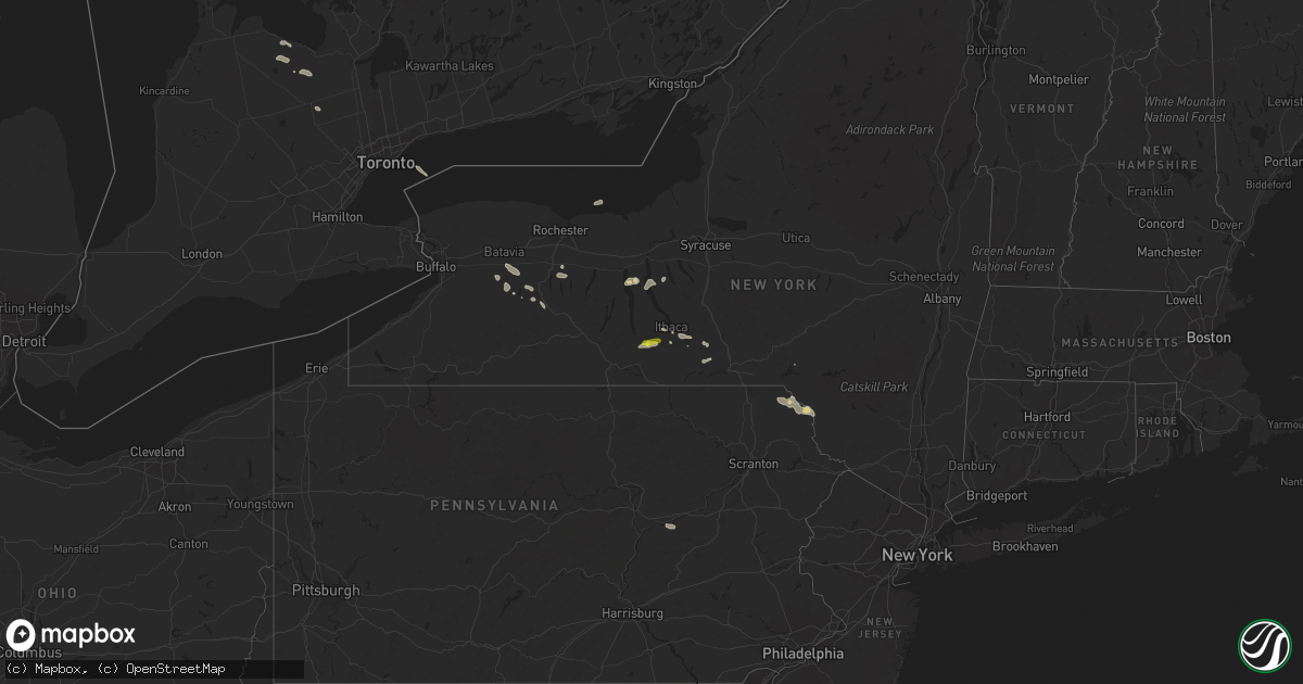
Hail Map on June 15, 2022
Get this storm
June 15 map
$229
one time, instant access
Download today. No call, no setup
Keep the $229
Bought the map and want the full workflow? Apply the entire $229 to a subscription within 7 days. None of it is wasted.
Every map, not just this one
This buys you this map. Subscription and you get every map we run, in the markets you choose from a few cities to whole states to nationwide. Plus real-time alerts the moment a storm fires.
Contact data
Name, contact info, occupancy, even credit band for addresses in the footprint. You go from where it hit to who to call.
Become the source they trust
Unlimited branding weather history reports on demand. You already have the documented answer ready for the property owner, and you are the one who showed up with it.
Property data and RoofTrace estimates
Pull up any address you have got, its value and the exact code rules for that jurisdiction, straight from One Click Code. Then RoofTrace estimates the squares, pitch, and roof value, priced the way you price.
States Impacted by Hail Map on June 15, 2022
Storm reports
Alabama
| Date | Description |
|---|---|
| 06/15/20226:59 PM CDT | Spotter reported golf ball sized hail along hwy 80 near crawford. |
| 06/15/20226:44 PM CDT | Trees and powerlines blown down. |
| 06/15/20226:43 PM CDT | Hail up to quarter size reported via social media. A few trees reported down in the same area. |
| 06/15/20225:43 PM CDT | Corrects previous hail report from 6 s eufaula country club. Hail up to quarter size reported via social media. A few trees reported down in the same area. |
| 06/15/20225:40 PM CDT | A few trees were blown down near us highway 80. |
| 06/15/20224:20 PM CDT | Dime to quarter size hail reported on charlotte drive in south huntsville. Report relayed via social media. |
| 06/15/20224:15 PM CDT | Tree down at the intersection of carl t. Jones and garth road. Time estimated by radar. |
| 06/15/20224:15 PM CDT | Corrects previous non-tstm wnd gst report from craig field airport. Awos station ksem selma craig fld. |
| 06/15/20224:11 PM CDT | Tree down and some powerlines down near huntsville hospital. Time estimated via radar. |
| 06/15/20224:11 PM CDT | Tree and power line damage along marsheutz avenue in huntsville. |
| 06/15/20224:09 PM CDT | Reports of pea to quarter size hail south of huntsville... Report relayed via social media. |
| 06/15/202210:06 AM CDT | A few trees blown down around clanton. |
| 06/15/20229:40 AM CDT | A few trees blown down around troy. |
| 06/15/20225:00 AM CDT | At 959 PM CDT, severe thunderstorms were located along a line extending from near Thorsby to near White Hall to near Logan, moving west at 40 mph. HAZARD...60 mph wind gusts. SOURCE...Radar indicated. IMPACT...Expect damage to roofs, siding, and trees. Locations impacted include... Selma, Clanton, Valley Grande, Marion, Uniontown, Mosses, Selmont-West Selmont, Maplesville, Gordonville, Orrville, Newbern, Benton, Bogue Chitto, Vaiden, Parnell, Tyler, Dannelly Reservoir, Mulberry, Paul M Grist State Park and Dallas Lake. |
| 06/15/20224:56 AM CDT | At 956 PM CDT, a severe thunderstorm was located near Sardis City, or 8 miles east of Boaz, moving northwest at 30 mph. HAZARD...60 mph wind gusts. SOURCE...Radar indicated. IMPACT...Expect damage to roofs, siding, and trees. Locations impacted include... Albertville, Scottsboro, Boaz, Guntersville, Arab, Rainsville, Crossville, Fyffe, Hollywood and Powell. |
| 06/15/20224:53 AM CDT | At 952 PM CDT, a severe thunderstorm was located near Monroeville, moving southwest at 20 mph. HAZARD...60 mph wind gusts and penny size hail. SOURCE...Radar indicated. IMPACT...Expect damage to roofs, siding, and trees. Locations impacted include... Monroeville, Frisco City, Uriah and Excel. |
| 06/15/20224:46 AM CDT | At 946 PM CDT, severe thunderstorms were located along a line extending from 11 miles southwest of Rutledge to 12 miles north of Gantt to 3 miles northwest of Dozier to Opp, moving southwest at 20 mph. HAZARD...60 mph wind gusts and penny size hail. SOURCE...Radar indicated. IMPACT...Expect damage to roofs, siding, and trees. Locations impacted include... Andalusia, Opp, McKenzie, River Falls, Red Level, Dozier, Heath and Gantt. |
| 06/15/20224:26 AM CDT | At 926 PM EDT, a severe thunderstorm was located near Felton, or near Buchanan, moving northwest at 10 mph. HAZARD...60 mph wind gusts and quarter size hail. SOURCE...Radar indicated. IMPACT...Hail damage to vehicles is expected. Expect wind damage to roofs, siding, and trees. Locations impacted include... Tallapoosa, Felton, Antioch and Esom Hill. |
| 06/15/20224:19 AM CDT | At 918 PM CDT, severe thunderstorms were located along a line extending from near Speed to Pike Road to near Linwood, moving west at 25 mph. HAZARD...60 mph wind gusts. Trees have been knoced down with this line of storms. SOURCE...Emergency management. IMPACT...Expect damage to roofs, siding, and trees. Locations impacted include... Montgomery, Prattville, Troy, Millbrook, Wetumpka, Fort Deposit, Mosses, Hayneville, Meadville, Pike Road, Elmore, Coosada, Deatsville, Autaugaville, White Hall, Gordonville, Billingsley, Lowndesboro, Hyundai Motors Of Alabama and Santuck. |
| 06/15/20224:06 AM CDT | At 906 PM CDT, severe thunderstorms were located along a line extending from near Ball Flat to near Bynum, moving west at 35 mph. HAZARD...60 mph wind gusts. SOURCE...Radar indicated. IMPACT...Expect damage to roofs, siding, and trees. Locations impacted include... Gadsden, Rainbow City, Attalla, Hokes Bluff, Springville, Glencoe, Ashville, Sardis City, Ragland, Steele, Altoona, Walnut Grove, Reece City, Tabor Road, Aurora, Ballplay, Gadsden Mall, Noccalula Falls, Neely Henry Lake and Southside. |
| 06/15/20223:42 AM CDT | At 842 PM CDT, severe thunderstorms were located along a line extending from 7 miles south of Rome to 6 miles southeast of Piedmont, moving northwest at 30 mph. HAZARD...60 mph wind gusts. SOURCE...Radar indicated. IMPACT...Expect damage to roofs, siding, and trees. Locations impacted include... Centre, Cedar Bluff, Little River Canyon National Preserve, Forney, Centre Municipal Airport, Leesburg, Sand Rock, Gaylesville, Tennala, Cherokee Rock Village, Pleasant Gap, Cornwall Furnace Park, Blanche, Eastern Weiss Lake, Little River Falls, Slackland, Western Weiss Lake, Moshat, Ball Flat and Coloma. |
| 06/15/20223:33 AM CDT | At 833 PM CDT, severe thunderstorms were located along a line extending from Mars Hills to 6 miles north of Delta, moving west at 15 mph. HAZARD...60 mph wind gusts. SOURCE...Radar indicated. IMPACT...Expect damage to roofs, siding, and trees. Locations impacted include... Anniston, Oxford, Jacksonville, Piedmont, Cobb Town, West End-Cobb Town, Fort McClellan, Saks, Glencoe, Weaver, Ohatchee, Hobson City, Blue Mountain, Alexandria, Jacksonville State University, Oxford Lake, Bynum, Neely Henry Lake, Southside and Choccolocco. |
| 06/15/20223:30 AM CDT | At 830 PM CDT, severe thunderstorms were located along a line extending from 6 miles northeast of Liberty City to Tuskegee, moving west at 15 mph. HAZARD...60 mph wind gusts and quarter size hail. SOURCE...Radar indicated. IMPACT...Hail damage to vehicles is expected. Expect wind damage to roofs, siding, and trees. Locations impacted include... Tuskegee, Tallassee, Notasulga, Milstead, Eclectic, Shorter, Franklin, Martin Dam, Reeves Airport, Lake Tuskegee, Davisville, Southern Lake Martin, Liverpool, Liberty City, Tallapoosa City, Tysonville, Victoryland, Kowaliga Bridge, Still Waters Resort and Western Lake Martin. |
| 06/15/20223:24 AM CDT | At 824 PM EDT, a severe thunderstorm was located over Dawson, moving west at 15 mph. HAZARD...60 mph wind gusts. SOURCE...Radar indicated. IMPACT...Expect damage to roofs, siding, and trees. Locations impacted include... Fort Gaines, Dawson, Cuthbert, Georgetown, Shellman, Wire Bridge, Walter F George Lake, Bonapartes Retreat, Standleys Store, Carnegie, Watson Crossroads, Crossroads, Ricks Place, Pecan, Randolph Co A/p, Dawson Municipal A/P, Aycock Mill, Hatcher, Morris and Jones Crossing. |
| 06/15/20223:23 AM CDT | At 823 PM CDT, severe thunderstorms were located along a line extending from near Spring Hill to Pickett, moving west at 15 mph. HAZARD...60 mph wind gusts and quarter size hail. SOURCE...Radar indicated. IMPACT...Hail damage to vehicles is expected. Expect wind damage to roofs, siding, and trees. Locations impacted include... Union Springs, Midway, Pickett, Aberfoil, Spring Hill, Comer, Barbour County Public Lake Dam, Beans Crossroads, Three Notch, Batesville, Perote and Mount Andrew. |
| 06/15/20223:13 AM CDT | At 813 PM CDT, severe thunderstorms were located along a line extending from 6 miles southwest of Rockmart to Ranburne, moving west at 15 mph. HAZARD...60 mph wind gusts. SOURCE...Radar indicated. IMPACT...Expect damage to roofs, siding, and trees. Locations impacted include... Heflin, Ranburne, Fruithurst, Edwardsville, Muscadine, Abernathy, Mars Hills, Mount Cheaha, Hollis Crossroads, Sweetwater Lake, Coleman Lake And Campground, Trickem, Lake Cleburne, I 20 Welcome Center, Liberty Hill, Chalafinnee, Oak Level, Borden Springs and Camp Sequoyah. |
| 06/15/20223:10 AM CDT | At 810 PM CDT, severe thunderstorms were located along a line extending from Corinth to near Wadley, moving west at 20 mph. HAZARD...60 mph wind gusts. SOURCE...Radar indicated. IMPACT...Expect damage to roofs, siding, and trees. Locations impacted include... Lineville, Ashland, Lake Wedowee, Woodland, Morrison Cross Roads, Barfield, Fosters Cross Roads, Delta, Corinth, Cleveland Crossroads, Cragford, R.L. Harris Dam, Ofelia, Motley, Lake Chinnabee, Millerville, Mellow Valley and Gunthertown. |
| 06/15/20223:09 AM CDT | At 809 PM CDT, a severe thunderstorm was located near Ozark, moving west at 20 mph. HAZARD...60 mph wind gusts. SOURCE...Radar indicated. IMPACT...Expect damage to roofs, siding, and trees. Locations impacted include... Daleville, Elba, Enterprise, Fort Rucker, Ozark, Level Plains, Newton, New Brockton, Ariton, Pinckard, Lee, Kinston, Mixons Crossroads, Hunt Field, Waterford, Curtis, Carl Folsom A/p, Hooper Stage Field, Gerald and Camp Humming Hills. |
| 06/15/20223:07 AM CDT | At 807 PM EDT, a severe thunderstorm was located over Cannonville, or near LaGrange, moving west at 35 mph. HAZARD...60 mph wind gusts and quarter size hail. SOURCE...Radar indicated. IMPACT...Hail damage to vehicles is expected. Expect wind damage to roofs, siding, and trees. Locations impacted include... LaGrange, West Point, Southern Harbor, Cannonville, State Line Park, Abbottsford, Rocky Point, Piedmont Heights, Wares Crossroads, Baughs Crossroads, Smiths Crossroad, Long Cane and Jones Crossroads. |
| 06/15/20223:07 AM CDT | At 807 PM CDT, severe thunderstorms were located along a line extending from near Griffen Mill to 6 miles north of Spring Hill, moving west at 15 mph. HAZARD...60 mph wind gusts. SOURCE...Radar indicated. IMPACT...Expect damage to roofs, siding, and trees. Locations impacted include... Tuskegee, Union Springs, Hurtsboro, Russell County Sports Complex, Uchee, Seale, Lake Tuskegee, Guerryton, Ladonia, Davisville, Society Hill, Griffen Mill, Warriorstand, Sedgefield, Fort Davis, Creek Stand, Rutherford, Monterey Heights, Hatchechubbe and Ladonia Sports Complex. |
| 06/15/20223:02 AM CDT | At 802 PM CDT, a severe thunderstorm was located near Tuskegee National Forest, or near Auburn, moving west at 20 mph. HAZARD...60 mph wind gusts and quarter size hail. SOURCE...Radar indicated. IMPACT...Hail damage to vehicles is expected. Expect wind damage to roofs, siding, and trees. Locations impacted include... Auburn, Tuskegee, Tallassee, Notasulga, Franklin, Waverly, Martin Dam, Liberty City, Reeves Airport, Auburn University, Tallapoosa City, Tuskegee National Forest, Southern Lake Martin, Loachapoka, Yates Dam, I 85 Rest Area, Uphapee Creek, Chewacla State Park, Roxana and Reeltown. |
| 06/15/20222:51 AM CDT | At 750 PM CDT, a severe thunderstorm was located over Brundidge, moving west at 15 mph. HAZARD...60 mph wind gusts and quarter size hail. SOURCE...Radar indicated. IMPACT...Hail damage to vehicles is expected. Expect wind damage to roofs, siding, and trees. Locations impacted include... Troy, Brundidge, Goshen, Antioch, Tennille, Tarentum, Brundidge Municipal Airport, Hamilton Crossroads, Springhill, Mossy Grove and Henderson. |
| 06/15/20222:45 AM CDT | At 745 PM CDT, a severe thunderstorm was located near Shelton State Community College, or 9 miles southwest of Tuscaloosa, and is nearly stationary. HAZARD...60 mph wind gusts and quarter size hail. SOURCE...Radar indicated. IMPACT...Hail damage to vehicles is expected. Expect wind damage to roofs, siding, and trees. Locations impacted include... Southwestern Tuscaloosa, Northport, Shelton State Community College, Tuscaloosa Amphitheater, Tuscaloosa Regional Airport, Englewood, Little Sandy, Maxwell, Taylorville, Fosters Boat Landing, Hull, Palmore Park, Stillman College, Fosters, Romulus and Oliver Lock And Dam. |
| 06/15/20222:36 AM CDT | At 736 PM CDT, severe thunderstorms were located along a line extending from Abanda to Waverly, moving west at 20 mph. HAZARD...60 mph wind gusts and penny size hail. SOURCE...Radar indicated. IMPACT...Expect damage to roofs, siding, and trees. Locations impacted include... Alexander City, Dadeville, Camp Hill, Jacksons' Gap, New Site, Waverly, Goldville, Hillabee Creek, Eastern Lake Martin, Western Lake Martin, Northern Lake Martin, Wind Creek State Park, Still Waters Resort, Southern Lake Martin, Daviston, Susannah Crossing, Maxwell Gunter Recreation Area, Blue Creek Marina, Horseshoe Bend National Military Park and Hackneyville. |
| 06/15/20222:21 AM CDT | At 720 PM CDT, a severe thunderstorm was located over Abbeville, moving west at 15 mph. HAZARD...60 mph wind gusts. SOURCE...Radar indicated. IMPACT...Expect damage to roofs, siding, and trees. Locations impacted include... Abbeville, Fort Rucker, Ozark, Enterprise, New Brockton, Ariton, Newville, Haleburg, Mixons Crossroads, Hooper Stage Field, Camp Humming Hills, Clintonville, Ewell, Roeton, Dale County Lake, Camp Alaflo Bsa, Phillips Crossroads, Arcus, Hwy 231 Pea River Bridge and Balkum. |
| 06/15/20222:20 AM CDT | At 720 PM CDT, a severe thunderstorm was located 7 miles southeast of Moundville, or 17 miles north of Greensboro, and is nearly stationary. HAZARD...60 mph wind gusts and quarter size hail. SOURCE...Radar indicated. IMPACT...Hail damage to vehicles is expected. Expect wind damage to roofs, siding, and trees. Locations impacted include... Moundville, Mound State Park, Elliots Creek, Wateroak, Moundville Airport, Phipps, Havana, Hull and Harper Hill. |
| 06/15/20222:12 AM CDT | At 712 PM CDT, a severe thunderstorm was located over Tyler Crossroads, or near Clio, moving west at 20 mph. HAZARD...60 mph wind gusts and quarter size hail. SOURCE...Radar indicated. IMPACT...Hail damage to vehicles is expected. Expect wind damage to roofs, siding, and trees. Locations impacted include... Clio, Louisville, Blue Springs, Tyler Crossroads, Doster and Blue Springs State Park. |
| 06/15/20221:48 AM CDT | At 648 PM EDT, a severe thunderstorm was located near Hamilton, moving southwest at 20 mph. HAZARD...60 mph wind gusts and quarter size hail. SOURCE...Radar indicated. IMPACT...Hail damage to vehicles is expected. Expect wind damage to roofs, siding, and trees. Locations impacted include... Columbus, Hamilton, Bibb City, Upatoi, Goat Rock Lake, Ellerslie, Saint Marys Hills, Edgewood, Flat Rock, Highland Park, Laurel Hills, Green Island Hills, Vista Terrace, Cataula, Columbus Metropolitan Airport, Rose Hill, Midland, Kenwood, Mountain Hill and Avondale. |
| 06/15/20221:07 AM CDT | At 606 PM CDT, a severe thunderstorm was located over western Birmingham, and is nearly stationary. HAZARD...60 mph wind gusts and penny size hail. SOURCE...Radar indicated. IMPACT...Expect damage to roofs, siding, and trees. Locations impacted include... Birmingham, Hoover, Vestavia Hills, Bessemer, Homewood, Mountain Brook, Hueytown, Irondale, Fairfield, Pleasant Grove, Midfield, Adamsville, Brighton, Lipscomb, Sylvan Springs, Mulga, Birmingham Fairgounds, B.j.c.c., Edgewater and Kingston. |
| 06/15/202212:20 AM CDT | At 520 PM CDT, severe thunderstorms were located along a line extending from Marion Junction to Dannelly Reservoir, moving west at 10 mph. HAZARD...60 mph wind gusts. SOURCE...Radar indicated. IMPACT...Expect damage to roofs, siding, and trees. Locations impacted include... Uniontown, Orrville, Bogue Chitto, Dannelly Reservoir, Marion Junction, Central Mills, Perry County Correctional Center, Crumptonia and Safford. |
| 06/15/202212:07 AM CDT | At 507 PM CDT, a severe thunderstorm was located near Blountsville, and is nearly stationary. HAZARD...60 mph wind gusts. SOURCE...Radar indicated. IMPACT...Expect damage to roofs, siding, and trees. Locations impacted include... Holly Pond and Walter. |
| 06/15/202212:04 AM CDT | At 504 PM CDT, a severe thunderstorm was located over Blountsville, and is nearly stationary. HAZARD...60 mph wind gusts. SOURCE...Radar indicated. IMPACT...Expect damage to roofs, siding, and trees. Locations impacted include... Blountsville, Cleveland, Nectar, Fowler Spring and Chamblees Mill. |
| 06/14/202211:45 PM CDT | At 444 PM CDT, severe thunderstorms were located along a line extending from near Potter Station to near Dallas Lake, and are nearly stationary. HAZARD...60 mph wind gusts. SOURCE...Radar indicated. IMPACT...Expect damage to roofs, siding, and trees. Locations impacted include... Selma, Orrville, Belknap, Bogue Chitto, Dallas Lake, Dannelly Reservoir, Marion Junction, Dallas County Horse Arena, Potter Station, Memorial Stadium, Skyharbor Airport, Whites Bluff, Hazen and Crumptonia. |
| 06/14/202211:45 PM CDT | At 445 PM CDT, a severe thunderstorm was located near Redstone Arsenal, moving north at 10 mph. HAZARD...60 mph wind gusts and quarter size hail. SOURCE...Radar indicated. IMPACT...Hail damage to vehicles is expected. Expect wind damage to roofs, siding, and trees. Locations impacted include... Huntsville, Redstone Arsenal, University Of Alabama In Huntsville and Farley. |
| 06/14/202211:22 PM CDT | At 422 PM CDT, a severe thunderstorm was located over Tyler, or 9 miles southeast of Selmont-West Selmont, moving southwest at 5 mph. HAZARD...60 mph wind gusts and penny size hail. SOURCE...Radar indicated. IMPACT...Expect damage to roofs, siding, and trees. Locations impacted include... Selma, Selmont-West Selmont, White Hall, Benton, Old Cahaba Park, Tyler, Selma Drag Strip, Collirene, Edmund Pettus Bridge and Craig Field Aiport. |
| 06/14/202210:56 PM CDT | At 356 PM CDT, a severe thunderstorm was located over southeastern Huntsville, moving north at 10 mph. HAZARD...60 mph wind gusts and quarter size hail. SOURCE...Radar indicated. IMPACT...Hail damage to vehicles is expected. Expect wind damage to roofs, siding, and trees. Locations impacted include... Huntsville, Madison, Moores Mill, Redstone Arsenal, Meridianville, Alabama A And M University, University Of Alabama In Huntsville and Hampton Cove. |
| 06/14/202210:07 PM CDT | A few trees were blown down. |
| 06/14/202210:06 PM CDT | Corrects previous tstm wnd dmg report from clanton. A few trees blown down around clanton. |
| 06/14/20229:53 PM CDT | Report of multiple trees down in the arab vicinity. Time estimated based on radar. |
| 06/14/20229:43 PM CDT | Trees were blown down outside gallant. |
| 06/14/20229:40 PM CDT | Corrects previous tstm wnd dmg report from troy. A few trees blown down around troy. |
| 06/14/20229:40 PM CDT | Trees down in ashland. |
| 06/14/20229:40 PM CDT | Numerous trees were blown down around ashland. Some of these trees blocked roadways and a few landed on vehicles. |
| 06/14/20229:37 PM CDT | Broadcast media relayed pictures of two uprooted pecan trees in the boaz area. Time estimated based on radar. |
| 06/14/20229:37 PM CDT | Several trees and power lines were blown down around steele. |
| 06/14/20229:32 PM CDT | Numerous reports of trees down across etowah county. Several have fallen on homes. Details pending. |
| 06/14/20229:32 PM CDT | Trees down in ragland. |
| 06/14/20229:32 PM CDT | Several trees and powerlines were blown down. Dispatch received at least 8 calls of damage. |
| 06/14/20229:32 PM CDT | Several trees and powerlines down. |
| 06/14/20229:32 PM CDT | A couple of trees blown down around pell city. |
| 06/14/20229:30 PM CDT | Trees and power lines down. |
| 06/14/20229:27 PM CDT | Several trees down... Power outages. |
| 06/14/20229:16 PM CDT | Trees and power lines down around wetumpka. |
| 06/14/20229:16 PM CDT | Numerous trees and power lines were blown down around wetumpka. The city received at least 24 calls of damage. |
| 06/14/20229:15 PM CDT | Multiple trees down in and around ohatchee. |
| 06/14/20229:05 PM CDT | Trees blown down... Power outages. |
| 06/14/20229:05 PM CDT | Trees blown down across southern portions of the county. |
| 06/14/20229:03 PM CDT | Trees and power lines down. |
| 06/14/20229:01 PM CDT | One tree down on forest lake drive. |
| 06/14/20229:00 PM CDT | Multiple trees down in and around the city of anniston. |
| 06/14/20228:55 PM CDT | Corrects previous tstm wnd dmg report from 6 n choccolocco. Trees blown down... Numerous power outages reported. |
| 06/14/20228:55 PM CDT | Several trees and power lines were blown down around tallassee. The city received at least 9 calls of damage. |
| 06/14/20228:55 PM CDT | Several trees blown down... Power outages. |
| 06/14/20228:50 PM CDT | Several trees down on st francis rd with power outages reported overnight. Additional trees were downed in the historic district in eufaula on us 431. |
| 06/14/20228:44 PM CDT | Kanb measured 44 mph wind gust along outflow. |
| 06/14/20228:40 PM CDT | One tree down. |
| 06/14/20228:39 PM CDT | Trees blown down. |
| 06/14/20228:35 PM CDT | Multiple trees down along county road 308. |
| 06/14/20228:30 PM CDT | Numerous trees and power lines reported down... Mainly across the southern half of cleburne county. The most widespread tree damage was reported in micaville and ranbur |
| 06/14/20228:27 PM CDT | Several trees blown down... Power outages. |
| 06/14/20228:15 PM CDT | Trees blown down... Power outages. |
| 06/14/20228:15 PM CDT | Several reports of trees blown down. |
| 06/14/20228:13 PM CDT | One tree down at east 27 and east 36. |
| 06/14/20228:04 PM CDT | Reported on social media. |
| 06/14/20228:03 PM CDT | Trees blown down. |
| 06/14/20227:55 PM CDT | Trees blown down... Numerous power outages reported. |
| 06/14/20227:55 PM CDT | One tree down on hwy 54. |
| 06/14/20227:52 PM CDT | Several trees blown down. |
| 06/14/20227:28 PM CDT | Several trees down north of moundville. Winds estimated at 50-60 mph. |
| 06/14/20227:06 PM CDT | Trees blown down near lee rd 2089. |
Pennsylvania
| Date | Description |
|---|---|
| 06/15/20222:50 AM CDT | Tree and wired down on route 97. Time estimated from radar. |
| 06/15/20222:45 AM CDT | Trees down in manchester township. Time estimated from radar. |
New York
| Date | Description |
|---|---|
| 06/15/20224:07 AM CDT | At 905 PM EDT, a severe thunderstorm was located near Dansville, moving southeast at 15 mph. HAZARD...60 mph wind gusts and quarter size hail. SOURCE...Radar indicated. IMPACT...Minor damage to vehicles is possible. Expect wind damage to trees and power lines. Locations impacted include... Dansville, Groveland, Springwater, Ossian, Ossian Center and Sonyea.This includes Interstate 390 between exits 4 and 6. |
| 06/15/20223:15 AM CDT | At 814 PM EDT, a severe thunderstorm was located near Pavilion, or 7 miles southeast of Batavia, moving east at 15 mph. HAZARD...60 mph wind gusts and quarter size hail. SOURCE...Radar indicated. IMPACT...Minor damage to vehicles is possible. Expect wind damage to trees and power lines. Locations impacted include... Geneseo, Le Roy, Avon, Mount Morris, Pavilion, Caledonia, Lima, York, Stafford and Livonia.This includes Interstate 390 between exits 7 and 10. |
| 06/15/20223:12 AM CDT | Trees and wires down on route 114. Time estimated from radar. |
| 06/15/20222:23 AM CDT | Tree down blocking the roadway. Hooper rd and pheasant ln. |
| 06/15/20222:15 AM CDT | Power lines and poles down on route 12 and county road 2. Time estimated from radar. |
| 06/15/20222:15 AM CDT | Tree down on route 12. Time estimated from radar. |
| 06/15/20221:46 AM CDT | Tree down on wires. Time estimated from radar. |
| 06/15/20221:38 AM CDT | Tree down on powerlines. Time estimated from radar. |
| 06/15/20221:36 AM CDT | Delayed report from facebook of estimated 0.5-1 inch hail in danby. |
| 06/15/20221:36 AM CDT | Delayed repo |
| 06/15/20221:31 AM CDT | Tree down on a road at cornell university... Blocking both lanes. Time estimated from radar. |
| 06/15/20221:28 AM CDT | Tree down across road in the city of ithaca. Time estimated from radar. |
| 06/15/20221:20 AM CDT | Large tree down on route 38 between stony hill rd and tucker hill rd. |
| 06/14/20227:29 PM CDT | Tree down and then snapped off a power pole. |
Minnesota
| Date | Description |
|---|---|
| 06/15/202211:34 AM CDT | Trees and power lines down just to the northwest of caledonia. |
| 06/15/202211:02 AM CDT | Reports of trees down and some structural damage just south of harmony. |
| 06/15/202210:30 AM CDT | Dime up to quarter sized hail. |
Michigan
| Date | Description |
|---|---|
| 06/15/20229:30 AM CDT | Poplar tree snapped halfway up the tree on the bluff in gladstone. Another tree was snapped near the base of the trunk. Report via social media. |
| 06/15/20229:28 AM CDT | Escanaba public safety dispatch reports of a damaged tree on a power line near the michigan dnr station in escanaba. |
| 06/15/20225:51 AM CDT | At 1051 PM EDT, severe thunderstorms were located along a line extending from Traverse City to Buckley, moving east at 30 mph. HAZARD...60 mph wind gusts and penny size hail. SOURCE...Radar indicated. IMPACT...Expect damage to roofs, siding, and trees. Severe thunderstorms will be near... Traverse City and Traverse City State Park around 1055 PM EDT. Kingsley around 1105 PM EDT. Williamsburg around 1110 PM EDT.Other locations in the path of these severe thunderstorms includeBarker Creek, Fife Lake, Rapid City, Kalkaska, South Boardman andAntrim. |
| 06/15/20225:25 AM CDT | At 1025 AM EDT, a severe thunderstorm was located over Gladstone, or 7 miles north of Escanaba, moving northeast at 45 mph. HAZARD...60 mph wind gusts and quarter size hail. SOURCE...Radar indicated. IMPACT...Hail damage to vehicles is expected. Expect wind damage to roofs, siding, and trees. This severe thunderstorm will be near... Rapid River around 1030 AM EDT. |
| 06/15/20225:18 AM CDT | At 1017 PM EDT, severe thunderstorms were located along a line extending from near Whitefish Point to near Raco to 8 miles northeast of Allenville, moving northeast at 60 mph. HAZARD...60 mph wind gusts. SOURCE...Radar indicated. IMPACT...Expect damage to roofs, siding, and trees. Severe thunderstorms will be near... Dafter and Brimley State Park around 1025 PM EDT. Sault Ste. Marie around 1030 PM EDT. Pickford, Kelden and Stalwart around 1035 PM EDT.Other locations in the path of these severe thunderstorms includeBarbeau and Munuscong. |
| 06/15/20224:43 AM CDT | At 942 AM EDT/842 AM CDT/, a severe thunderstorm was located 8 miles north of Stephenson, or 27 miles southwest of Escanaba, moving northeast at 35 mph. HAZARD...60 mph wind gusts and quarter size hail. SOURCE...Radar indicated. IMPACT...Hail damage to vehicles is expected. Expect wind damage to roofs, siding, and trees. Locations impacted include... Escanaba. |
| 06/15/20224:29 AM CDT | At 929 PM EDT, severe thunderstorms were located along a line extending from near Grand Marais to near Curtis, moving east at 35 mph. HAZARD...60 mph wind gusts and quarter size hail. SOURCE...Radar indicated. IMPACT...Hail damage to vehicles is expected. Expect wind damage to roofs, siding, and trees. Locations impacted include... Muskallonge State Park. |
| 06/15/20224:25 AM CDT | 8 inch tree limb down at intersection of 4th street and state street. Time estimated by radar. |
| 06/15/20224:23 AM CDT | At 923 PM EDT, severe thunderstorms were located along a line extending from 10 miles northwest of Grand Marais to Gould City to 12 miles west of Saint James On Beaver Island, moving northeast at 60 mph. HAZARD...60 mph wind gusts. SOURCE...Radar indicated. IMPACT...Expect damage to roofs, siding, and trees. Severe thunderstorms will be near... Engadine around 930 PM EDT. Naubinway around 935 PM EDT. Gilchrist and Garnet around 940 PM EDT.Other locations in the path of these severe thunderstorms includeHulbert, Eckerman, Epoufette, Brevort, Strongs, Trout Lake, EastLake, Bayview Campground and Fibre. |
| 06/15/20224:22 AM CDT | At 921 PM EDT, severe thunderstorms were located along a line extending from near Seney to 16 miles southeast of Manistique, moving east at 40 mph. HAZARD...60 mph wind gusts and quarter size hail. SOURCE...Radar indicated. IMPACT...Hail damage to vehicles is expected. Expect wind damage to roofs, siding, and trees. Severe thunderstorms will be near... Seney around 930 PM EDT. |
| 06/15/20224:10 AM CDT | Tree down. Time estimated by radar. |
| 06/15/20224:03 AM CDT | At 903 PM EDT, a severe thunderstorm was located near Chatham, or 8 miles southwest of Munising, moving northeast at 55 mph. HAZARD...60 mph wind gusts and quarter size hail. SOURCE...Radar indicated. IMPACT...Hail damage to vehicles is expected. Expect wind damage to roofs, siding, and trees. This severe thunderstorm will be near... Munising around 915 PM EDT. Pictured Rocks National Lakeshore Miners Castle and Shingleton around 920 PM EDT.Other locations in the path of this severe thunderstorm includeChapel Lake. |
| 06/15/20223:49 AM CDT | Central dispatch reported scattered trees down in the western and central part of huron county. Some locations include sebewaing... Owendale... Filion... And ubly |
| 06/15/20223:40 AM CDT | Central dispatch reported over a dozen trees downed and snapped across northern tuscola county. |
| 06/15/20223:25 AM CDT | Large limbs down. |
| 06/15/20223:20 AM CDT | Numerous trees down in the area of tittabawassee and lawndale roads. Time radar estimated. |
| 06/15/20223:12 AM CDT | Saginaw international airport wind gust. |
| 06/15/20221:51 AM CDT | At 651 PM CDT, severe thunderstorms were located along a line extending from 7 miles southeast of Pound to 9 miles northeast of Oconto to 12 miles west of Sturgeon Bay to near Luxemburg to Bellevue Town, moving northeast at 70 mph. HAZARD...70 mph wind gusts. SOURCE...Radar indicated. IMPACT...Expect considerable tree damage. Damage is likely to mobile homes, roofs, and outbuildings. Severe thunderstorms will be near... Bay Shore Park, Algoma and Luxemburg around 700 PM CDT. Marinette, Sturgeon Bay and Menominee around 705 PM CDT. Egg Harbor around 710 PM CDT.Other locations in the path of these severe thunderstorms includeJacksonport, Ephraim and Newport State Park. |
| 06/15/20221:15 AM CDT | At 615 PM CDT, severe thunderstorms were located along a line extending from near Navarino Wildlife Area to 8 miles north of Black Creek to 9 miles north of Little Chute to near Darboy, moving northeast at 75 mph. HAZARD...70 mph wind gusts. SOURCE...Radar indicated. IMPACT...Expect considerable tree damage. Damage is likely to mobile homes, roofs, and outbuildings. Severe thunderstorms will be near... Green Bay, Pulaski and Bellevue Town around 625 PM CDT. Gillett around 630 PM CDT. Bay Shore Park and Denmark around 635 PM CDT.Other locations in the path of these severe thunderstorms includeOconto, Luxemburg, Kewaunee, Algoma, Marinette, Sturgeon Bay,Menominee and Egg Harbor. |
| 06/15/202212:56 AM CDT | At 556 AM CDT, a severe thunderstorm was located 8 miles west of Tipler, or 13 miles southwest of Iron River, moving northeast at 40 mph. HAZARD...60 mph wind gusts. SOURCE...Radar indicated. IMPACT...Expect damage to roofs, siding, and trees. This severe thunderstorm will be near... Wisconsin Slough Natural Area around 605 AM CDT. |
| 06/14/202210:06 PM CDT | A few trees down near bates and sayler rd. |
| 06/14/20229:50 PM CDT | Delayed report from social media... Estimated brief quarter size hail. Time estimated from radar. |
| 06/14/20229:31 PM CDT | Awos at chippewa county intl aiport. |
| 06/14/20228:08 PM CDT | Tree down and large swing blown down. Report via social media. |
| 06/14/20227:10 PM CDT | Trees down. Report via social media with picture. |
Montana
| Date | Description |
|---|---|
| 06/15/202211:41 AM CDT | Manning corral raws |
South Dakota
| Date | Description |
|---|---|
| 06/14/20228:00 PM CDT | At 1259 AM CDT, a severe thunderstorm was located 4 miles west of Bloomfield, or 19 miles southwest of Lewis And Clark State Recreation Area, moving northeast at 60 mph. HAZARD...Ping pong ball size hail and 60 mph wind gusts. SOURCE...Radar indicated. IMPACT...People and animals outdoors will be injured. Expect hail damage to roofs, siding, windows, and vehicles. Expect wind damage to roofs, siding, and trees. This severe thunderstorm will be near... Crofton around 115 AM CDT.Other locations in the path of this severe thunderstorm includeYankton. |
Tennessee
| Date | Description |
|---|---|
| 06/15/20221:09 AM CDT | At 608 PM EDT, a severe thunderstorm was located 7 miles northeast of Murphy, moving northwest at 15 mph. HAZARD...60 mph wind gusts. SOURCE...Radar indicated. IMPACT...Expect damage to roofs, siding, and trees. Locations impacted include... Andrews and Marble. |
| 06/15/202212:01 AM CDT | At 501 PM CDT, a severe thunderstorm was located near New Market, or 7 miles northeast of Moores Mill, moving north at 10 mph. HAZARD...60 mph wind gusts and quarter size hail. SOURCE...Radar indicated. IMPACT...Hail damage to vehicles is expected. Expect wind damage to roofs, siding, and trees. Locations impacted include... New Market, Lincoln, Skinem, Plevna, Flintville, Elora and Crystal Springs. |
Georgia
| Date | Description |
|---|---|
| 06/15/20226:55 PM CDT | Tree across the newnan road |
| 06/15/20226:52 PM CDT | Quarter-sized hail reported near willow ln. |
| 06/15/20226:52 PM CDT | Trees snapped in northern clay county. |
| 06/15/20226:51 PM CDT | Tree down across cheatham road |
| 06/15/20226:50 PM CDT | Multiple trees down |
| 06/15/20226:45 PM CDT | Multiple trees down |
| 06/15/20226:43 PM CDT | Structural roof damage to a business along broad st |
| 06/15/20226:43 PM CDT | 20+ reports of trees and powerlines downed across roads in the city of griffin. North cherokee avenue to terrace street on the south side to spalding street on the east |
| 06/15/20226:43 PM CDT | Tree down across east maddox road |
| 06/15/20226:42 PM CDT | Tree down on a house along south 6th st |
| 06/15/20226:42 PM CDT | Tree on a house on day street |
| 06/15/20226:42 PM CDT | Tree down on a house on maddox road |
| 06/15/20226:41 PM CDT | Tree on a house on daniel street |
| 06/15/20226:41 PM CDT | Tree down on a house on 6th street. Powerlines also downed. |
| 06/15/20226:40 PM CDT | Tree on a house along south mcdonough road |
| 06/15/20226:35 PM CDT | Numerous trees downed along bucksnort road along and up to the butts and spalding county line |
| 06/15/20226:35 PM CDT | Trees down across swint road |
| 06/15/20226:35 PM CDT | Several trees reported down in the city of greenville |
| 06/15/20226:34 PM CDT | Tree and powerlines down across high falls park rd near bell rd. |
| 06/15/20226:33 PM CDT | Tree down on a house along lakeshore drive |
| 06/15/20226:25 PM CDT | Roof blown off of a home on dromedary st. |
| 06/15/20226:22 PM CDT | Tree down at the intersection of hwy 103 and goose creek rd. |
| 06/15/20226:22 PM CDT | Roof off a building in woodbury near cedar st. |
| 06/15/20226:22 PM CDT | Reports of 2 traffic lights blown off the pole at the intersection of 74 and 85. |
| 06/15/20226:22 PM CDT | 2 trees down |
| 06/15/20226:20 PM CDT | 2 houses with trees on them along riggins ferry rd southeast of woodbury |
| 06/15/20226:20 PM CDT | Ema reporting over 300+ trees downed in and around jones mill road and flat shoals road. Radar confirms presence of downburst signature in the area. |
| 06/15/20226:20 PM CDT | Several trees reported down at the intersection of hwy 85 and main st. Traffic light blown off pole. |
| 06/15/20226:18 PM CDT | Multiple trees down along mt vernon church rd near intersection of mountain view rd |
| 06/15/20226:15 PM CDT | Multiple trees down |
| 06/15/20226:12 PM CDT | Roof off a structure along river cove road |
| 06/15/20226:12 PM CDT | Multiple trees down on 2 separate house along homestead cir |
| 06/15/20226:10 PM CDT | 2 trees down |
| 06/15/20226:05 PM CDT | Quarter-sized hail reported near maple dr and s 6th st in griffin. |
| 06/15/20225:57 PM CDT | Tree reported down at the intersection of hwy 116 and rd brown rd. |
| 06/15/20225:55 PM CDT | Tree down at the intersection of nelson rd and pleasant grove rd. |
| 06/15/20225:51 PM CDT | Tree reported down at the intersection of hwy 315 and old warm springs rd. |
| 06/15/20225:50 PM CDT | Quarter-sized hail reported near intersection of bo bo banks rd and allen rd. |
| 06/15/20225:49 PM CDT | Tree down at the intersection of ginn lake and ginn dr. |
| 06/15/20225:48 PM CDT | Multiple trees down near the intersection of harris rd and ginn dr |
| 06/15/20225:46 PM CDT | Tree reported down at the intersection of hwy 315 and old warm springs rd. |
| 06/15/20225:44 PM CDT | Tree reported down at the intersection of hwy 27 and lake lorraine dr. |
| 06/15/20225:41 PM CDT | Tree down near the intersection harris rd and ga-208 |
| 06/15/20225:40 PM CDT | Multiple trees down near the intersection of harris rd and ginn dr |
| 06/15/20225:40 PM CDT | Tree down at the intersection of ginn lake and ginn dr. |
| 06/15/20225:35 PM CDT | Quarter size hail reported in utapoi |
| 06/15/20225:33 PM CDT | Tree and powerline reported down at the intersection of s hwy 29 and oaklawn rd. |
| 06/15/20225:24 PM CDT | Approximately 650f homes in fort valley were without power per em. |
| 06/15/20225:23 PM CDT | Tree down on home with structural damage near the intersection of tower rd and wynnmeade pkwy |
| 06/15/20225:22 PM CDT | Tree reported down across the road on hwy 54 near intersection with sunset dr. |
| 06/15/20225:16 PM CDT | Tree reported down in a yard on macintosh estates ct. |
| 06/15/20225:16 PM CDT | Multiple trees down near intersection of joel cowan pkwy and kelly dr |
| 06/15/20225:16 PM CDT | Half dollar size hail reported near intersection of driftwood ct and fishers luck. |
| 06/15/20225:16 PM CDT | 1 inch hail observed on macintosh estates ct. |
| 06/15/20225:12 PM CDT | Quarter-sized hail reported near intersection of hwy 126 and johnny martin rd. |
| 06/15/20225:10 PM CDT | 1 inch hail observed at balmoral village near s peachtree pkwy. |
| 06/15/20225:10 PM CDT | 1 tree down |
| 06/15/20225:04 PM CDT | Quarter to ping pong ball-sized hail reported near intersection of southshore rd and twin bridges rd. |
| 06/15/20225:00 PM CDT | Multiple trees down |
| 06/15/20225:00 PM CDT | A tree fell on a house |
| 06/15/20223:56 PM CDT | Quarter-sized hail reported near intersection of county line rd and ethridge mill rd. |
| 06/15/20224:45 AM CDT | At 945 PM EDT, a severe thunderstorm was located over Buchanan, moving northwest at 20 mph. HAZARD...60 mph wind gusts and penny size hail. SOURCE...Radar indicated. IMPACT...Expect damage to roofs, siding, and trees. Locations impacted include... Buchanan, Bremen, Rockmart, Tallapoosa, Waco, Yorkville, Draketown, Eubank Lake and Van Wert. |
| 06/15/20224:07 AM CDT | At 907 PM EDT, a severe thunderstorm was located near Blackjack Mountain, or 12 miles southwest of Carrollton, moving northwest at 15 mph. HAZARD...60 mph wind gusts and quarter size hail. SOURCE...Radar indicated. IMPACT...Hail damage to vehicles is expected. Expect wind damage to roofs, siding, and trees. Locations impacted include... Bowdon, Ephesus, Tyus and Blackjack Mountain. |
| 06/15/20224:01 AM CDT | At 901 PM EDT, severe thunderstorms were located along a line extending from near Braswell to John Tanner State Park, moving northwest at 10 mph. HAZARD...60 mph wind gusts and quarter size hail. SOURCE...Radar indicated. IMPACT...Hail damage to vehicles is expected. Expect wind damage to roofs, siding, and trees. Locations impacted include... Carrollton, Dallas, Buchanan, Villa Rica, Bremen, Temple, Rockmart, Tallapoosa, Mount Zion, Waco, Braswell, Yorkville, Eubank Lake, Bowdon Junction, Van Wert, Abilene, Draketown, John Tanner State Park and New Georgia. |
| 06/15/20223:38 AM CDT | At 838 PM CDT, a severe thunderstorm was located over Georgetown, moving west at 15 mph. HAZARD...60 mph wind gusts. SOURCE...Radar indicated. IMPACT...Expect damage to roofs, siding, and trees. Locations impacted include... Eufaula, Clio, Clayton, Louisville, Hawkinsville, Gaino, Osco, Richards Crossroads, White Oak, Lakepoint Resort State Park, Boot Hill, Millers Ford, Clayton Municipal Airport, Twin Springs, Lugo and Baker Hill. |
| 06/15/20223:32 AM CDT | At 832 PM EDT, a severe thunderstorm was located near Clayton, or near Tiger, moving northwest at 15 mph. HAZARD...Quarter size hail. SOURCE...Radar indicated. IMPACT...Minor damage to vehicles is expected. Locations impacted include... Clayton, Mountain City, Tiger, Lake Rabun, Lake Burton, Lakemont, Black Rock Mountain State Park, Seed Lake and Tallulah Falls. |
| 06/15/20223:25 AM CDT | At 825 PM EDT, a severe thunderstorm was located near Kingston, or 9 miles east of Rome, moving north at 10 mph. HAZARD...60 mph wind gusts and quarter size hail. SOURCE...Radar indicated. IMPACT...Hail damage to vehicles is expected. Expect wind damage to roofs, siding, and trees. Locations impacted include... Rome, Euharlee, Kingston and Shannon. |
| 06/15/20223:04 AM CDT | At 804 PM EDT, a severe thunderstorm was located near Lone Oak, or 8 miles north of Greenville, moving west at 35 mph. HAZARD...60 mph wind gusts and quarter size hail. SOURCE...Radar indicated. IMPACT...Hail damage to vehicles is expected. Expect wind damage to roofs, siding, and trees. Locations impacted include... Newnan, LaGrange, Hogansville, Grantville, Luthersville, Moreland, Sharpsburg, Turin, Lone Oak, East Newnan, Corinth, Rocky Mount, Saint Marks, Louise, Powers Crossroads, Handy, Harrisonville, Hillcrest, Thomas Crossroads and Wooster. |
| 06/15/20222:41 AM CDT | At 741 PM EDT, a severe thunderstorm was located over Murrays Crossroads, or 7 miles north of Ellaville, moving southwest at 30 mph. HAZARD...60 mph wind gusts and quarter size hail. SOURCE...Radar indicated. IMPACT...Hail damage to vehicles is expected. Expect wind damage to roofs, siding, and trees. Locations impacted include... Buena Vista, Ellaville, Putnam, Brantley, Murrays Crossroads, Tazewell, Doyle, Fountainville, Rupert, Charing, Draneville and Walls Crossing. |
| 06/15/20222:39 AM CDT | At 739 PM EDT/639 PM CDT/, a severe thunderstorm was located 9 miles north of Fort Gaines, moving west at 10 mph. HAZARD...60 mph wind gusts and nickel size hail. SOURCE...Radar indicated. IMPACT...Expect damage to roofs, siding, and trees. Locations impacted include... Fort Gaines, Days Crossroads, Wire Bridge, Walter F George Lake, Bonapartes Retreat, Standleys Store, Otho, Watson Crossroads, Scottsboro Crossroads, Double Bridges, Moores Crossroads, Crossroads, Ricks Place, Garnersville, Screamer, Coates, Bagby State Park, Thomas Mill Creek, Hatcher and Morris. |
| 06/15/20222:33 AM CDT | At 733 PM EDT, a severe thunderstorm was located over Chappel Mill, or 8 miles east of Griffin, moving west at 35 mph. HAZARD...60 mph wind gusts and quarter size hail. SOURCE...Radar indicated. IMPACT...Hail damage to vehicles is expected. Expect wind damage to roofs, siding, and trees. Locations impacted include... Griffin, Zebulon, Peachtree City, Senoia, Milner, Brooks, Williamson, Sharpsburg, Turin, Orchard Hill, Haralson, Woolsey, Sunny Side, East Griffin, Starrs Mill, Walker Mill, Hollonville, Inman, Rover and Liberty Hill. |
| 06/15/20222:30 AM CDT | At 730 PM EDT, a severe thunderstorm was located near Leesburg, moving west at 10 mph. HAZARD...60 mph wind gusts and quarter size hail. SOURCE...Radar indicated. IMPACT...Hail damage to vehicles is expected. Expect wind damage to roofs, siding, and trees. Locations impacted include... Dawson, Leesburg, Smithville, Sasser, Bronwood, Parrott, Bridges Crossroad, Herod, Jordan Place, Yeomans, Clarks Mill, Dawson Municipal A/P, Starksville, Byne Crossroads, Graves, Scrutchins, Armena, Oakville, Chambliss and Olivers Mill. |
| 06/15/20222:30 AM CDT | At 730 PM EDT, a severe thunderstorm was located over Odessadale, or near Greenville, moving west at 25 mph. HAZARD...60 mph wind gusts and quarter size hail. SOURCE...Radar indicated. IMPACT...Hail damage to vehicles is expected. Expect wind damage to roofs, siding, and trees. Locations impacted include... LaGrange, Greenville, Manchester, Warm Springs, Raleigh, Mountville, Louise, Odessadale, Stovall, Big Springs, Durand, Baughs Crossroads, Harris City, Smiths Crossroad and Jones Crossroads. |
| 06/15/20222:22 AM CDT | At 722 PM EDT, a severe thunderstorm was located over Butler, moving southwest at 15 mph. HAZARD...60 mph wind gusts and quarter size hail. SOURCE...Radar indicated. IMPACT...Hail damage to vehicles is expected. Expect wind damage to roofs, siding, and trees. Locations impacted include... Butler, Howard, Wesley Church and Fickling Mill. |
| 06/15/20222:21 AM CDT | At 721 PM EDT, a severe thunderstorm was located over Handy, or 9 miles west of Newnan, moving west at 10 mph. HAZARD...60 mph wind gusts and quarter size hail. SOURCE...Radar indicated. IMPACT...Hail damage to vehicles is expected. Expect wind damage to roofs, siding, and trees. Locations impacted include... Franklin, Whitesburg, Centralhatchee, Roopville, Plant Yates, Lowell, Plant Wansley, Powers Crossroads and Handy. |
| 06/15/20222:11 AM CDT | At 711 PM EDT, a severe thunderstorm was located over Berner, or 9 miles southeast of Jackson, moving west at 10 mph. HAZARD...60 mph wind gusts and quarter size hail. SOURCE...Radar indicated. IMPACT...Hail damage to vehicles is expected. Expect wind damage to roofs, siding, and trees. Locations impacted include... Jackson, Flovilla, McElheneys Crossroads, Indian Springs State Park and Blount. |
| 06/15/20222:09 AM CDT | At 709 PM CDT, severe thunderstorms were located along a line extending from near Ephesus to Amity Park, moving west at 20 mph. HAZARD...60 mph wind gusts and quarter size hail. SOURCE...Radar indicated. IMPACT...Hail damage to vehicles is expected. Expect wind damage to roofs, siding, and trees. Locations impacted include... Valley, Lanett, Roanoke, Wedowee, Lafayette, Stroud, La Fayette, Wadley, Woodland, Waverly, Lakeview, Five Points, Cusseta, Malone, Post Oak Forks, Denson, River View, Amity Park, Sturkie and Abanda. |
| 06/15/20222:07 AM CDT | At 707 PM EDT, a severe thunderstorm was located over Crest, or 8 miles northwest of Thomaston, moving west at 10 mph. HAZARD...60 mph wind gusts and quarter size hail. SOURCE...Radar indicated. IMPACT...Hail damage to vehicles is expected. Expect wind damage to roofs, siding, and trees. Locations impacted include... Thomaston, Manchester, Woodbury, Molena, Sunset Village, Sprewell Bluff State Park, Crest, Sunnyside, Atwater, Lifsey Springs, Hannahs Mill and Imlac. |
| 06/15/20222:05 AM CDT | At 704 PM EDT, a severe thunderstorm was located over Hogansville, or 12 miles south of Newnan, moving southwest at 10 mph. HAZARD...60 mph wind gusts and quarter size hail. SOURCE...Radar indicated. IMPACT...Hail damage to vehicles is expected. Expect wind damage to roofs, siding, and trees. Locations impacted include... Hogansville, Grantville, Corinth, Louise and Harrisonville. |
| 06/15/20221:53 AM CDT | At 653 PM EDT, a severe thunderstorm was located over Marshallville, or 8 miles southwest of Fort Valley, moving southwest at 15 mph. HAZARD...60 mph wind gusts and quarter size hail. SOURCE...Radar indicated. IMPACT...Hail damage to vehicles is expected. Expect wind damage to roofs, siding, and trees. Locations impacted include... Fort Valley, Oglethorpe, Montezuma, Marshallville, Reynolds, Ideal, Saint Louis, Whitewater State Park, Nakomis, Meadowdale, Garden Valley, Hicks, Potterville, Clearview, Lee Pope, Winchester and Bartlett. |
| 06/15/20221:52 AM CDT | At 651 PM EDT, a severe thunderstorm was located over Chattahoochee Hills, or 12 miles north of Newnan, moving west at 5 mph. HAZARD...60 mph wind gusts and quarter size hail. SOURCE...Radar indicated. IMPACT...Hail damage to vehicles is expected. Expect wind damage to roofs, siding, and trees. Locations impacted include... Palmetto, Whitesburg, Chattahoochee Hills, Dunaway Gardens, Plant Yates, Byers Crossroads, Hannah, Roscoe, Fairplay and Bill Arp. |
| 06/15/20221:51 AM CDT | At 651 PM EDT, a severe thunderstorm was located over Walker Mill, or near Griffin, moving west at 15 mph. HAZARD...60 mph wind gusts and quarter size hail. SOURCE...Radar indicated. IMPACT...Hail damage to vehicles is expected. Expect wind damage to roofs, siding, and trees. Locations impacted include... Griffin, Orchard Hill, Sunny Side, East Griffin, Highland Mills, Rover, Towalaga, Experiment and Walker Mill. |
| 06/15/20221:45 AM CDT | At 645 PM EDT, a severe thunderstorm was located over Round Oak, or 9 miles northwest of Gray, moving west at 25 mph. HAZARD...60 mph wind gusts and quarter size hail. SOURCE...Radar indicated. IMPACT...Hail damage to vehicles is expected. Expect wind damage to roofs, siding, and trees. Locations impacted include... Forsyth, Bradley, Bolingbroke, Wayside, Hillsboro, Dames Ferry, Berner, Round Oak, Juliette, Plant Scherer and Jarrell Plantation. |
| 06/15/20221:41 AM CDT | At 641 PM EDT, a severe thunderstorm was located over East Newnan, or near Newnan, moving west at 5 mph. HAZARD...60 mph wind gusts and quarter size hail. SOURCE...Radar indicated. IMPACT...Hail damage to vehicles is expected. Expect wind damage to roofs, siding, and trees. Locations impacted include... Newnan, Grantville, Moreland and East Newnan. |
| 06/15/20221:18 AM CDT | At 618 PM CDT, severe thunderstorms were located along a line extending from River View to Columbus, moving west at 20 mph. HAZARD...60 mph wind gusts. SOURCE...Radar indicated. IMPACT...Expect damage to roofs, siding, and trees. Locations impacted include... Auburn, Phenix City, Opelika, Valley, Smiths, Smiths Station, Cusseta, Beulah, Beans Mill, River View, Beauregard, Sturkie, Bleecker, Chambers County Lake, Fairfax, Ladonia, Oak Bowery, Griffen Mill, Huguley and Bibb City. |
| 06/15/20221:17 AM CDT | At 617 PM EDT, a severe thunderstorm was located over Miami Valley, or near Fort Valley, moving northwest at 25 mph. HAZARD...60 mph wind gusts and quarter size hail. SOURCE...Radar indicated. IMPACT...Hail damage to vehicles is expected. Expect wind damage to roofs, siding, and trees. Locations impacted include... Fort Valley, Roberta, Byron, Reynolds, Knoxville, Nakomis, Powerville, Lee Pope, Horns, Miami Valley and Lakewood. |
| 06/15/20221:04 AM CDT | At 604 PM EDT, a severe thunderstorm was located over Peachtree City, or 8 miles southwest of Fayetteville, moving southwest at 10 mph. HAZARD...60 mph wind gusts and quarter size hail. SOURCE...Radar indicated. IMPACT...Hail damage to vehicles is expected. Expect wind damage to roofs, siding, and trees. Locations impacted include... Newnan, Peachtree City, Tyrone, Senoia, Brooks, Sharpsburg, Turin, Haralson, East Newnan, Starrs Mill and Thomas Crossroads. |
| 06/15/20221:01 AM CDT | At 601 PM EDT, a severe thunderstorm was located over Ethridge, or 11 miles south of Eatonton, moving southwest at 20 mph. HAZARD...60 mph wind gusts and quarter size hail. SOURCE...Radar indicated. IMPACT...Hail damage to vehicles is expected. Expect wind damage to roofs, siding, and trees. Locations impacted include... Milledgeville, Gray, Meriwether, Ethridge, Bradley, Wayside, Haddock, Resseaus Crossroads, Round Oak, Clinton, Plant Harlee Branch, Browns Crossing, Stanfordville and Blountsville. |
| 06/15/202212:47 AM CDT | At 546 PM EDT, a severe thunderstorm was located over Woodland, or 7 miles north of Talbotton, moving west at 15 mph. HAZARD...60 mph wind gusts and quarter size hail. SOURCE...Radar indicated. IMPACT...Hail damage to vehicles is expected. Expect wind damage to roofs, siding, and trees. Locations impacted include... Talbotton, Waverly Hall, Woodland, Pleasant Hill and Olive Branch. |
| 06/15/202212:43 AM CDT | At 543 PM CDT, a severe thunderstorm was located near Richards Crossroads, or 7 miles south of Eufaula, moving southwest at 10 mph. HAZARD...60 mph wind gusts and penny size hail. SOURCE...Radar indicated. IMPACT...Expect damage to roofs, siding, and trees. Locations impacted include... Richards Crossroads. |
| 06/15/202212:31 AM CDT | At 531 PM EDT, a severe thunderstorm was located over Soperton, moving west at 15 mph. HAZARD...60 mph wind gusts and quarter size hail. SOURCE...Radar indicated. IMPACT...Hail damage to vehicles is expected. Expect wind damage to roofs, siding, and trees. Locations impacted include... Soperton, Tarrytown, Lothair, Orland, Rockledge, Orianna, Barnhill, Kibbee, Minter, Lowery, Blackville, Zaidee and Gillis Springs. |
| 06/15/202212:19 AM CDT | At 519 PM EDT, a severe thunderstorm was located over Charles, or near Lumpkin, moving southwest at 10 mph. HAZARD...60 mph wind gusts and quarter size hail. SOURCE...Radar indicated. IMPACT...Hail damage to vehicles is expected. Expect wind damage to roofs, siding, and trees. Locations impacted include... Lumpkin, Charles, Louvale and Providence Canyon State Park. |
| 06/14/202211:27 PM CDT | At 427 PM EDT, a severe thunderstorm was located 12 miles southeast of Franklin, or near Highlands, moving southwest at 10 mph. HAZARD...60 mph wind gusts and quarter size hail. SOURCE...Radar indicated. IMPACT...Minor hail damage to vehicles is expected. Expect wind damage to trees and power lines. Locations impacted include... Highlands, Scaly Mountain, Whiteside Mountain, Lake Glenville, Otto and Pine Mountain. |
| 06/14/20228:50 PM CDT | Several trees downed in the city of buchanan |
| 06/14/20228:45 PM CDT | Tree down across old hwy 100 at walkers creek |
| 06/14/20228:45 PM CDT | 3 trees reported downed in the city of bremen |
| 06/14/20228:32 PM CDT | Tree down on steadham road |
| 06/14/20228:30 PM CDT | Several trees downed in the city of tallapoosa |
| 06/14/20228:30 PM CDT | Delayed report of numerous trees down countywide. Time estimated by radar. |
| 06/14/20228:20 PM CDT | Numerous trees down |
| 06/14/20228:15 PM CDT | A tree fell on a house |
| 06/14/20228:12 PM CDT | 1 tree fell on a house |
| 06/14/20228:12 PM CDT | 1 tree fell on a mobile home |
| 06/14/20228:10 PM CDT | Quarter size hail reported near intersection of pleasant ridge ch rd and ga-113 |
| 06/14/20227:50 PM CDT | Observed along east wolf creek road... Relayed through rabun co wx facebook page. |
| 06/14/20227:35 PM CDT | Pine mountain asos |
| 06/14/20227:30 PM CDT | Damage to multiple farm buildings including a shredded hay barn and roofs torn off barns. Partial roof damage to home. Multiple trees and powerlines down on/around prop |
| 06/14/20227:11 PM CDT | Trees reported down in the town of gay |
| 06/14/20227:10 PM CDT | Damage to multiple farm buildings including a shredded hay barn and roofs torn off barns. Partial roof damage to home. Multiple trees and powerlines down on/around prop |
Nebraska
| Date | Description |
|---|---|
| 06/15/20227:55 AM CDT | At 1254 AM CDT, a severe thunderstorm was located near Odessa, or 12 miles southwest of Kearney, moving east at 45 mph. HAZARD...Ping pong ball size hail and 60 mph wind gusts. SOURCE...Radar indicated. IMPACT...People and animals outdoors will be injured. Expect hail damage to roofs, siding, windows, and vehicles. Expect wind damage to roofs, siding, and trees. This severe thunderstorm will be near... Kearney around 110 AM CDT.Other locations in the path of this severe thunderstorm includeGibbon and Shelton.This includes Interstate 80 between mile markers 255 and 292. |
| 06/15/20227:40 AM CDT | At 1240 AM CDT, a severe thunderstorm was located near Stockham, or 20 miles east of Hastings, moving east at 45 mph. HAZARD...Golf ball size hail and 60 mph wind gusts. SOURCE...Radar indicated. IMPACT...People and animals outdoors will be injured. Expect hail damage to roofs, siding, windows, and vehicles. Expect wind damage to roofs, siding, and trees. This severe thunderstorm will be near... Saronville and Stockham around 1245 AM CDT. Sutton around 1250 AM CDT. Henderson around 1255 AM CDT. Lushton around 100 AM CDT.Other locations in the path of this severe thunderstorm includeGrafton and Fairmont.This includes Interstate 80 between mile markers 325 and 352. |
| 06/15/20227:38 AM CDT | At 1238 AM CDT, a severe thunderstorm was located near York, moving east at 45 mph. HAZARD...Two inch hail and 70 mph wind gusts. SOURCE...Radar indicated. IMPACT...People and animals outdoors will be injured. Expect hail damage to roofs, siding, windows, and vehicles. Expect considerable tree damage. Wind damage is also likely to mobile homes, roofs, and outbuildings. This severe thunderstorm will be near... Waco around 1250 AM CDT.This includes Interstate 80 between mile markers 351 and 365. |
| 06/15/20227:35 AM CDT | At 1235 AM CDT, a severe thunderstorm was located 3 miles southeast of York, moving northeast at 45 mph. HAZARD...Two inch hail and 60 mph wind gusts. SOURCE...Radar indicated. IMPACT...People and animals outdoors will be injured. Expect hail damage to roofs, siding, windows, and vehicles. Expect wind damage to roofs, siding, and trees. This severe thunderstorm will be near... Utica around 1250 AM CDT. Goehner around 1255 AM CDT.Other locations in the path of this severe thunderstorm includeStaplehurst, Ulysses, Seward, Garland, Dwight and Bee.This includes Interstate 80 in Nebraska between mile markers 366 and392. |
| 06/15/20227:27 AM CDT | At 1227 AM CDT, severe thunderstorms were located along a line extending from 6 miles northeast of Smithfield to 8 miles north of Edison to Holbrook, moving east at 35 mph. HAZARD...60 mph wind gusts and half dollar size hail. SOURCE...Radar indicated. IMPACT...Hail damage to vehicles is expected. Expect wind damage to roofs, siding, and trees. Severe thunderstorms will be near... Smithfield around 1230 AM CDT. Bertrand around 1240 AM CDT. Edison around 1245 AM CDT.Other locations in the path of these severe thunderstorms includeLoomis, Holdrege, Funk and Atlanta. |
| 06/15/20227:24 AM CDT | At 1222 AM CDT, a severe thunderstorm was located near Minden, or 10 miles southeast of Kearney, moving east at 45 mph. HAZARD...Ping pong ball size hail and 60 mph wind gusts. SOURCE...Radar indicated. IMPACT...People and animals outdoors will be injured. Expect hail damage to roofs, siding, windows, and vehicles. Expect wind damage to roofs, siding, and trees. This severe thunderstorm will be near... Heartwell around 1235 AM CDT Hastings around 110 AM CDT.Other locations in the path of this severe thunderstorm includeKenesaw, Prosser, Juniata, and Hansen.This includes Interstate 80 between mile markers 274 and 316. |
| 06/15/20227:11 AM CDT | At 1211 AM CDT, a severe thunderstorm was located near Hastings, moving east at 45 mph. HAZARD...60 mph wind gusts and quarter size hail. SOURCE...Radar indicated. IMPACT...Hail damage to vehicles is expected. Expect wind damage to roofs, siding, and trees. This severe thunderstorm will be near... Hastings around 1215 AM CDT. Hansen around 1220 AM CDT. Trumbull and Inland around 1225 AM CDT.Other locations in the path of this severe thunderstorm includeHarvard.This includes Interstate 80 between mile markers 302 and 333. |
| 06/15/20227:02 AM CDT | At 1201 AM CDT, a severe thunderstorm was located over Pacific Junction, or 10 miles southeast of Offutt AFB, moving east at 40 mph. THIS IS A DESTRUCTIVE STORM FOR Northern Fremont County in southwestern Iowa... Western Montgomery County in southwestern Iowa... Mills County in southwestern Iowa... Southern Pottawattamie County in southwestern Iowa... Northwestern Page County in southwestern Iowa. HAZARD...80 mph wind gusts and nickel size hail. SOURCE...Radar indicated. IMPACT...Flying debris will be dangerous to those caught without shelter. Mobile homes will be heavily damaged. Expect considerable damage to roofs, windows, and vehicles. Extensive tree damage and power outages are likely. This severe thunderstorm will be near... Glenwood around 1205 AM CDT. Malvern and Silver City around 1215 AM CDT.Other locations in the path of this severe thunderstorm includeHastings, Emerson, Henderson, Red Oak and Elliott.This includes the following highways... Interstate 29 between mile markers 24 and 37. Interstate 80 in Iowa between mile markers 8 and 14. |
| 06/14/202210:37 PM CDT | At 337 AM CDT, a severe thunderstorm was located near Abie, or 11 miles northeast of David City, moving northeast at 45 mph. HAZARD...60 mph wind gusts and quarter size hail. SOURCE...Radar indicated. IMPACT...Hail damage to vehicles is expected. Expect wind damage to roofs, siding, and trees. This severe thunderstorm will be near... Morse Bluff around 350 AM CDT. North Bend around 355 AM CDT.Other locations in the path of this severe thunderstorm includeScribner and Hooper. |
| 06/14/202210:04 PM CDT | At 304 AM CDT, a severe thunderstorm was located over Shelby, or 17 miles west of David City, moving northeast at 45 mph. HAZARD...60 mph wind gusts and quarter size hail. SOURCE...Radar indicated. IMPACT...Hail damage to vehicles is expected. Expect wind damage to roofs, siding, and trees. This severe thunderstorm will be near... Rising City around 315 AM CDT.Other locations in the path of this severe thunderstorm include DavidCity, Bellwood, Richland, Octavia, Schuyler, Abie and Linwood. |
| 06/14/20229:31 PM CDT | At 231 AM CDT, a severe thunderstorm was located 7 miles north of Hampton, or 14 miles northwest of York, moving east at 55 mph. HAZARD...Quarter size hail. SOURCE...Radar indicated. IMPACT...Damage to vehicles is expected. This severe thunderstorm will be near... Polk around 235 AM CDT. Benedict around 245 AM CDT. Stromsburg around 250 AM CDT.Other locations in the path of this severe thunderstorm includeGresham. |
| 06/14/20228:31 PM CDT | At 131 AM CDT, a severe thunderstorm was located near Hampton, or 16 miles west of York, moving east at 55 mph. HAZARD...Golf ball size hail and 60 mph wind gusts. SOURCE...Radar indicated. IMPACT...People and animals outdoors will be injured. Expect hail damage to roofs, siding, windows, and vehicles. Expect wind damage to roofs, siding, and trees. This severe thunderstorm will be near... Henderson around 135 AM CDT. Bradshaw around 140 AM CDT. York around 150 AM CDT.Other locations in the path of this severe thunderstorm includeBenedict, Waco and Gresham.This includes Interstate 80 between mile markers 332 and 365. |
| 06/14/20228:14 PM CDT | At 113 AM CDT, a severe thunderstorm was located near Lewis And Clark State Recreation Area, moving northeast at 65 mph. HAZARD...60 mph wind gusts and half dollar size hail. SOURCE...Radar indicated. IMPACT...Hail damage to vehicles is expected. Expect wind damage to roofs, siding, and trees. This severe thunderstorm will be near... Yankton and Utica around 125 AM CDT. Mission Hill around 130 AM CDT.Other locations in the path of this severe thunderstorm includeMayfield, Volin, Irene, Wakonda, Centerville and Viborg. |
| 06/14/20228:12 PM CDT | At 111 AM CDT, a severe thunderstorm was located 4 miles east of Bee, or 9 miles northeast of Seward, moving northeast at 50 mph. HAZARD...Two inch hail and 70 mph wind gusts. SOURCE...Radar indicated. IMPACT...People and animals outdoors will be injured. Expect hail damage to roofs, siding, windows, and vehicles. Expect considerable tree damage. Wind damage is also likely to mobile homes, roofs, and outbuildings. This severe thunderstorm will be near... Valparaiso around 120 AM CDT. Ceresco and Weston around 130 AM CDT.Other locations in the path of this severe thunderstorm includeWahoo, Ithaca, Colon, Mead, Yutan and Leshara. |
| 06/14/20228:06 PM CDT | At 106 AM CDT, a severe thunderstorm was located near McCool Junction, or near York, moving east at 40 mph. HAZARD...60 mph wind gusts and quarter size hail. SOURCE...Radar indicated. IMPACT...Hail damage to vehicles is expected. Expect wind damage to roofs, siding, and trees. This severe thunderstorm will be near... McCool Junction around 110 AM CDT. York around 115 AM CDT. Waco around 125 AM CDT.This includes Interstate 80 between mile markers 343 and 365. |
| 06/14/20228:05 PM CDT | At 104 AM CDT, a severe thunderstorm was located over Hansen, or 10 miles north of Hastings, moving east at 40 mph. HAZARD...Golf ball size hail and 60 mph wind gusts. SOURCE...Radar indicated. IMPACT...People and animals outdoors will be injured. Expect hail damage to roofs, siding, windows, and vehicles. Expect wind damage to roofs, siding, and trees. This severe thunderstorm will be near... Trumbull around 110 AM CDT. Giltner around 120 AM CDT.Other locations in the path of this severe thunderstorm includeAurora, Stockham and Hampton.This includes Interstate 80 between mile markers 309 and 340. |
North Carolina
| Date | Description |
|---|---|
| 06/15/20225:35 PM CDT | Observed off of hankins and fish hatchery roads. |
| 06/15/20225:24 PM CDT | Several trees down. |
| 06/15/20225:10 PM CDT | Several trees down. |
| 06/15/20225:08 PM CDT | Observed at the golf course. |
| 06/15/20221:48 AM CDT | At 648 PM EDT, a severe thunderstorm was located 5 miles south of Spruce Pine, moving northwest at 10 mph. HAZARD...60 mph wind gusts and quarter size hail. SOURCE...Radar indicated. IMPACT...Minor hail damage to vehicles is expected. Expect wind damage to trees and power lines. Locations impacted include... Spruce Pine, Bakersville, Bandana, Ingalls, Woodlawn, North Cove, Micaville, Celo, Little Switzerland and Green Mountain. |
| 06/15/20221:01 AM CDT | At 601 PM EDT, a severe thunderstorm was located 6 miles east of Marion, or near Lake James State Park, moving south at 10 mph. HAZARD...60 mph wind gusts and quarter size hail. SOURCE...Radar indicated. IMPACT...Minor hail damage to vehicles is expected. Expect wind damage to trees and power lines. Locations impacted include... Marion, Glen Alpine, Lake James State Park, Lake James, Nebo, Sugar Hill, Thermal City, Glenwood, Fero and Dysartsville. |
| 06/15/202212:36 AM CDT | At 535 PM EDT, a severe thunderstorm was located near Hayesville, moving northwest at 5 mph. HAZARD...60 mph wind gusts and penny size hail. SOURCE...Radar indicated. IMPACT...Expect damage to roofs, siding, and trees. Locations impacted include... Hayesville and Tusquitee. |
| 06/14/202210:12 PM CDT | At 311 PM EDT, a severe thunderstorm was located 9 miles southeast of Sylva, or 5 miles east of Cullowhee, moving south at 10 mph. HAZARD...60 mph wind gusts and quarter size hail. SOURCE...Radar indicated. IMPACT...Minor hail damage to vehicles is expected. Expect wind damage to trees and power lines. Locations impacted include... Cullowhee, Cashiers, Lake Toxaway, Lake Glenville, Tuckasegee, Wolf Mountain, B.R. Parkway-Balsam Gap To Black Balsam Area and Sapphire. |
| 06/14/20229:38 PM CDT | At 238 PM EDT, a severe thunderstorm was located 8 miles northeast of Hendersonville, or 5 miles west of Bat Cave, moving south at 10 mph. HAZARD...60 mph wind gusts and quarter size hail. SOURCE...Radar indicated. IMPACT...Minor hail damage to vehicles is expected. Expect wind damage to trees and power lines. Locations impacted include... Hendersonville, Flat Rock, Laurel Park, Bat Cave, Valley Hill, Edneyville, Dana, Gerton, East Flat Rock and Saluda. |
Illinois
| Date | Description |
|---|---|
| 06/15/20222:43 AM CDT | Quarter size hail reported. |
| 06/15/20222:38 AM CDT | At 738 PM CDT, a severe thunderstorm was located over Malone, or 12 miles west of Clinton, moving northeast at 60 mph. HAZARD...60 mph wind gusts and penny size hail. SOURCE...Radar indicated. IMPACT...Expect damage to roofs, siding, and trees. This severe thunderstorm will be near... Camanche, Elvira and Clinton Municipal Airport around 745 PM CDT. Goose Lake and Bryant around 750 PM CDT. Clinton, Fulton, Andover, Teeds Grove and Bulgers Hollow around 755 PM CDT.Other locations in the path of this severe thunderstorm include CampMiss-Elk-Ton. |
| 06/15/20222:30 AM CDT | Metal pole barn heavily damaged at 1875 wiedman road. |
| 06/15/20222:18 AM CDT | Tree blown down and several tree branches at 404 garden lane in bay view gardens. Kiddi powl blown over neighbors fence. |
| 06/15/20221:25 AM CDT | At 625 PM CDT, a severe thunderstorm was located over Olds, or 10 miles north of Mount Pleasant, moving northeast at 40 mph. HAZARD...Ping pong ball size hail and 60 mph wind gusts. SOURCE...Radar indicated. IMPACT...People and animals outdoors will be injured. Expect hail damage to roofs, siding, windows, and vehicles. Expect wind damage to roofs, siding, and trees. This severe thunderstorm will be near... Crawfordsville around 630 PM CDT. Winfield, Mount Union and Wyman around 635 PM CDT. Marsh around 640 PM CDT. Columbus Junction, Columbus City, Cairo, Louisa County Fairgrounds and Virginia Grove Recreation Area around 645 PM CDT.Other locations in the path of this severe thunderstorm includeFredonia, Wapello, Grandview, Letts, Sand Springs, Snively AccessCampground and Flaming Prairie Park. |
Iowa
| Date | Description |
|---|---|
| 06/15/20225:13 PM CDT | Storms moving at a good clip - wind 35-40 mph. |
| 06/15/20225:09 PM CDT | Relayed from county sheriff office... Time estimated from radar. |
| 06/15/20225:05 PM CDT | Time estimated from radar... Report from mping: quarter |
| 06/15/20224:35 PM CDT | Branches of unknown size down west of epworth. |
| 06/15/202210:20 AM CDT | Branches around 3 inches in diameter down with pea size hail. Half an inch of rain in 5 minutes. |
| 06/15/202210:10 AM CDT | Trees and power lines downed. |
| 06/15/20227:43 AM CDT | At 1242 AM CDT, severe thunderstorms were located along a line extending from near Walnut to near Emerson, moving east at 35 mph. HAZARD...70 mph wind gusts and quarter size hail. SOURCE...Radar indicated. IMPACT...Hail damage to vehicles is expected. Expect considerable tree damage. Wind damage is also likely to mobile homes, roofs, and outbuildings. Locations impacted include... Atlantic, Griswold, Anita, Lewis, Massena, Cumberland, Marne, Wiota, Lake Anita State Park, Griswold Park, Cold Springs State Park, Atlantic Municipal Airport and Anita Municipal Airport.This includes Interstate 80 between mile markers 50 and 73. |
| 06/15/20227:40 AM CDT | At 1240 AM CDT, a severe thunderstorm was located near Carson, or 17 miles northwest of Red Oak, moving east at 55 mph. HAZARD...70 mph wind gusts and quarter size hail. SOURCE...Radar indicated. IMPACT...Hail damage to vehicles is expected. Expect considerable tree damage. Wind damage is also likely to mobile homes, roofs, and outbuildings. This severe thunderstorm will remain over mainly rural areas of northern Montgomery, northeastern Mills and southeastern Pottawattamie Counties, including the following locations... Botna Bend Park, Old Town Park and Farm Creek Public Wildlife Area. |
| 06/15/20227:35 AM CDT | At 1234 AM CDT, a severe thunderstorm was located near Osage, moving east at 30 mph. HAZARD...Quarter size hail. SOURCE...Radar indicated. IMPACT...Damage to vehicles is expected. This severe thunderstorm will be near... Osage around 1240 AM CDT. Riceville around 110 AM CDT.Other locations impacted by this severe thunderstorm include RockCreek, Idlewilde State Park, Howardville, Brownville, County Roads B20 And T 26, Highways 9 And 218 and Colwell County Park. |
| 06/15/20227:12 AM CDT | At 1211 AM CDT, a severe thunderstorm was located 10 miles east of Audubon, moving northeast at 35 mph. HAZARD...60 mph wind gusts and quarter size hail. SOURCE...Radar indicated. IMPACT...Hail damage to vehicles is expected. Expect wind damage to roofs, siding, and trees. This severe thunderstorm will be near... Guthrie Center around 1230 AM CDT.Other locations in the path of this severe thunderstorm include LakePanorama, Bayard, Springbrook State Park, Bagley, Yale and LakinSlough Game Management Area. |
| 06/15/20225:52 AM CDT | At 1051 AM CDT, severe thunderstorms were located along a line extending from near Lime Springs to near Protivin, moving east at 50 mph. HAZARD...60 mph wind gusts and quarter size hail. SOURCE...Law enforcement has reported nickel sized hail in Alta Vista and some pockets of minor wind damage in since 1030 am. IMPACT...Hail damage to vehicles is expected. Expect wind damage to roofs, siding, and trees. Severe thunderstorms will be near... Ridgeway around 1100 AM CDT. Decorah around 1115 AM CDT.Other locations impacted by these severe thunderstorms includeHesper, Highlandville, Burr Oak, Glenwood Church, Bluffton, ChimneyRock Campground and Locust. |
| 06/15/20225:25 AM CDT | At 1024 AM CDT, a severe thunderstorm was located near Elma, or 13 miles east of Osage, moving northeast at 50 mph. HAZARD...60 mph wind gusts and quarter size hail. SOURCE...Law enforcement. Trees and power lines were downed near Rudd around 1010 am. IMPACT...Hail damage to vehicles is expected. Expect wind damage to roofs, siding, and trees. This severe thunderstorm will be near... Lime Springs around 1045 AM CDT. Cresco around 1050 AM CDT.Other locations impacted by this severe thunderstorm include LylahsMarsh County Park, Vernon Springs County Park, Saratoga, County RoadsB 33 And T 76, County B 17 And Bell Avenue, Maple Leaf and VernonSprings. |
| 06/15/20225:18 AM CDT | At 1018 PM CDT, a severe thunderstorm was located near Rochester, or near Tipton, moving northeast at 50 mph. HAZARD...60 mph wind gusts and half dollar size hail. SOURCE...Radar indicated. IMPACT...Hail damage to vehicles is expected. Expect wind damage to roofs, siding, and trees. This severe thunderstorm will be near... Bennett around 1025 PM CDT. New Liberty and Bennett Park around 1030 PM CDT. Lowden and Big Rock around 1035 PM CDT.Other locations in the path of this severe thunderstorm includeWheatland, Calamus, Toronto, Walnut Grove Park, Sherman Park,Massillon Park, Grand Mound and Lost Nation. |
| 06/15/20225:07 AM CDT | At 1007 PM CDT, a severe thunderstorm was located near Saulsbury Bridge Campground, or near Muscatine, moving east at 50 mph. HAZARD...Ping pong ball size hail and 60 mph wind gusts. SOURCE...Radar indicated. IMPACT...People and animals outdoors will be injured. Expect hail damage to roofs, siding, windows, and vehicles. Expect wind damage to roofs, siding, and trees. This severe thunderstorm will be near... Muscatine, Wilton and Sweetland Center around 1020 PM CDT. Fairport, New Era, Wildcat Den State Park, Shady Creek Campground and Fairport Recreation Area around 1025 PM CDT.Other locations in the path of this severe thunderstorm includeDurant, Montpelier, Stockton, Pleasant Prairie, Midway Beach, Clark'sFerry Recreation Area, Blue Grass, Walcott, Buffalo, Maysville, WestLake Park, Plainview, Davenport, Rock Island, Eldridge, Long Grove,Donahue, Davenport Municipal Airport and Mississippi ValleyFairgrounds. |
| 06/15/20224:47 AM CDT | At 945 AM CDT, a severe thunderstorm was located near Rockford, or 10 miles southeast of Mason City, moving northeast at 55 mph. HAZARD...Quarter size hail. SOURCE...Radar indicated. IMPACT...Damage to vehicles is expected. This severe thunderstorm will be near... Rockford around 950 AM CDT. Rudd around 955 AM CDT. Charles City and Floyd around 1005 AM CDT.Other locations impacted by this severe thunderstorm include CountyRoads B 60 And T 18, Rock Creek, Idlewilde State Park, Roseville,Howardville, Brownville and County Roads B 20 And T 26. |
| 06/15/20222:07 AM CDT | At 707 PM CDT, severe thunderstorms were located along a line extending from Walcott to Muscatine, moving northeast at 60 mph. HAZARD...60 mph wind gusts and quarter size hail. SOURCE...Radar indicated. IMPACT...Hail damage to vehicles is expected. Expect wind damage to roofs, siding, and trees. Severe thunderstorms will be near... Walcott, Maysville and Plainview around 710 PM CDT. Davenport, Eldridge, Donahue and Davenport Municipal Airport around 715 PM CDT. Long Grove, Montpelier, Midway Beach, Wildcat Den State Park, Clark's Ferry Recreation Area, Park View, Pleasant Prairie, Loud Thunder Forest Preserve, Scott County Park and Loud Thunder Scout Camp around 720 PM CDT. Blue Grass, Andalusia, McCausland, Stockton and Buffalo Shores around 725 PM CDT.Other locations in the path of these severe thunderstorms includeBuffalo, Princeton, Cordova, Folletts, West Lake Park, Rock CreekMarina and Campground, Rock Creek Park, Princeton Wildlife Area,Credit Island, Rock Island, Camanche, Albany, Low Moor, MississippiValley Fairgrounds, Rock Island Arsenal, Blackhawk State Park,Moline, East Moline, Silvis, Riverdale, Panorama Park, CampbellsIsland, Bettendorf, Clinton, Le Claire, Hampton, Port Byron, RapidsCity, Fishermans Corner, Pleasant Valley and Illiniwek ForestPreserve. |
| 06/15/20222:00 AM CDT | At 700 PM CDT, a severe thunderstorm was located over Unionville, moving east at 40 mph. HAZARD...60 mph wind gusts and quarter size hail. SOURCE...Radar indicated. IMPACT...Hail damage to vehicles is expected. Expect wind damage to roofs, siding, and trees. Locations impacted include... Unionville, Queen City, Worthington, Livonia and Lemons. |
| 06/14/202211:48 PM CDT | At 448 PM CDT, a severe thunderstorm was located over Wapsipinicon Golf Course, or over Independence, moving northeast at 60 mph. HAZARD...Ping pong ball size hail and 60 mph wind gusts. SOURCE...Radar indicated. IMPACT...People and animals outdoors will be injured. Expect hail damage to roofs, siding, windows, and vehicles. Expect wind damage to roofs, siding, and trees. This severe thunderstorm will be near... Winthrop around 455 PM CDT. Stanley and Jakway Park around 500 PM CDT. Lamont and Aurora around 505 PM CDT.Other locations in the path of this severe thunderstorm includeBackbone State Park. |
| 06/14/202211:14 PM CDT | At 414 AM CDT, a severe thunderstorm was located near Fairbank, or near Oelwein, moving northeast at 35 mph. HAZARD...60 mph wind gusts and quarter size hail. SOURCE...Radar indicated. IMPACT...Hail damage to vehicles is expected. Expect wind damage to roofs, siding, and trees. This severe thunderstorm will remain over mainly rural areas of northwestern Buchanan County, including the following locations... Fontana County Park and Fontana Park. |
| 06/14/202211:09 PM CDT | At 409 AM CDT, a severe thunderstorm was located near Preston, moving northeast at 30 mph. HAZARD...60 mph wind gusts. SOURCE...Radar indicated. IMPACT...Expect damage to roofs, siding, and trees. This severe thunderstorm will be near... Harmony around 415 AM CDT. Preston around 420 AM CDT. Lanesboro around 435 AM CDT.Other locations impacted by this severe thunderstorm includeHenrytown, Choice, Old Barn Campground, Isinours, Hutton,Greenleafton and Peterson. |
| 06/14/202211:07 PM CDT | At 407 AM CDT, a severe thunderstorm was located 3 miles east of Hooper, or 11 miles north of Fremont, moving northeast at 50 mph. HAZARD...60 mph wind gusts and quarter size hail. SOURCE...Radar indicated. IMPACT...Hail damage to vehicles is expected. Expect wind damage to roofs, siding, and trees. This severe thunderstorm will be near... Herman around 425 AM CDT.Other locations in the path of this severe thunderstorm includeTekamah, Little Sioux and Pisgah.This includes Interstate 29 between mile markers 84 and 99. |
| 06/14/202211:03 PM CDT | At 402 AM CDT, a severe thunderstorm was located over Littleton, or 9 miles northwest of Independence, moving north at 35 mph. HAZARD...60 mph wind gusts and quarter size hail. SOURCE...Radar indicated. IMPACT...Hail damage to vehicles is expected. Expect wind damage to roofs, siding, and trees. This severe thunderstorm will be near... Fairbank and Hazleton around 420 AM CDT. |
| 06/14/202210:22 PM CDT | Em reported a tree down on private property. |
| 06/14/20229:58 PM CDT | At 257 AM CDT, severe thunderstorms were located along a line extending from near Reinbeck to 6 miles north of Toledo to near Meskwaki Casino, moving east at 30 mph. HAZARD...60 mph wind gusts. SOURCE...Radar indicated. IMPACT...Expect damage to roofs, siding, and trees. Locations impacted include... Toledo, Tama, La Porte City, Traer, Reinbeck, Dysart, Meskwaki Casino, Gladbrook, Le Grand, Garwin, Montour, Clutier, Elberon, Beaman, Lincoln, Morrison, Vining, Tf Clark State Park, Union Grove State Park and Toledo Municipal Airport.This includes Interstate 380 between mile markers 56 and 61. |
| 06/14/20229:54 PM CDT | At 254 AM CDT, a severe thunderstorm was located over Dike, or 8 miles west of Cedar Falls, moving northeast at 45 mph. HAZARD...60 mph wind gusts and quarter size hail. SOURCE...Radar indicated. IMPACT...Hail damage to vehicles is expected. Expect wind damage to roofs, siding, and trees. Locations impacted include... Waterloo, Cedar Falls, Waverly, Evansdale, Jesup, Hudson, Sumner, Parkersburg, Denver, Tripoli, Dike, Elk Run Heights, Crossroads Mall, Waterloo Municipal Airport, Uni-Dome And McLeod Center, Janesville, Washburn, Dunkerton, Readlyn and Raymond.This includes Interstate 380 between mile markers 60 and 73. |
| 06/14/20229:15 PM CDT | At 214 AM CDT, a severe thunderstorm was located near Eldora, moving northeast at 45 mph. HAZARD...60 mph wind gusts and quarter size hail. SOURCE...Radar indicated. IMPACT...Hail damage to vehicles is expected. Expect wind damage to roofs, siding, and trees. Locations impacted include... Iowa Falls, Eldora, Grundy Center, Reinbeck, Ackley, Dike, Conrad, Hubbard, Wellsburg, Union, Steamboat Rock, Liscomb, Holland, New Providence, Stout, Beaman, Whitten, Clemons, Buckeye and St. Anthony. |
| 06/14/20228:52 PM CDT | At 152 AM CDT, a severe thunderstorm was located 3 miles west of Leshara, or 7 miles south of Fremont, moving northeast at 50 mph. HAZARD...60 mph wind gusts and half dollar size hail. SOURCE...Radar indicated. IMPACT...Hail damage to vehicles is expected. Expect wind damage to roofs, siding, and trees. This severe thunderstorm will be near... Fremont, Leshara and Woodcliff around 155 AM CDT. Valley around 200 AM CDT. Arlington around 205 AM CDT. Bennington around 210 AM CDT.Other locations in the path of this severe thunderstorm includeKennard, Blair and Fort Calhoun. |
| 06/14/20228:47 PM CDT | At 147 AM CDT, a severe thunderstorm was located near Hospers, or 7 miles south of Sheldon, moving northeast at 50 mph. HAZARD...60 mph wind gusts and quarter size hail. SOURCE...Radar indicated. IMPACT...Hail damage to vehicles is expected. Expect wind damage to roofs, siding, and trees. This severe thunderstorm will be near... Sheldon and Paullina around 150 AM CDT. Archer around 155 AM CDT. Sanborn, Primghar and Sutherland around 200 AM CDT.Other locations in the path of this severe thunderstorm includeHartley, Melvin and Ocheyedan. |
| 06/14/20228:41 PM CDT | At 139 AM CDT, severe thunderstorms were located along a line extending from near Jefferson to near Stuart, moving northeast at 55 mph. HAZARD...60 mph wind gusts and penny size hail. SOURCE...Radar indicated. At 134 AM, Guthrie County emergency management reported 65 mph wind near the intersection of 310th street and Highway 25. IMPACT...Expect damage to roofs, siding, and trees. Locations impacted include... Urbandale, Waukee, Boone, Grimes, Perry, Jefferson, Adel, Guthrie Center, Madrid, Ogden, Stuart, Dallas Center, Granger, Panora, Woodward, Lake Panorama, Boone Speedway, Redfield, Grand Junction and Dexter.This includes Interstate 80 near mile marker 100. |
| 06/14/20228:23 PM CDT | Reported near the lodge at windy ridge... Time estimated from radar. |
| 06/14/20228:03 PM CDT | At 103 AM CDT, severe thunderstorms were located along a line extending from 9 miles east of Manning to Audubon to 8 miles north of Atlantic, moving northeast at 45 mph. HAZARD...60 mph wind gusts and nickel size hail. SOURCE...Radar indicated. IMPACT...Expect damage to roofs, siding, and trees. Locations impacted include... Jefferson, Audubon, Guthrie Center, Coon Rapids, Lake Panorama, Exira, Scranton, Bayard, Churdan, Templeton, Bagley, Dedham, Brayton, Willey, Ralston, Gray, Audubon County Airport and Springbrook State Park. |
| 06/14/20227:13 PM CDT | Relayed a report from fire department of tree down and transformer on fire at this location. |
| 06/14/20227:08 PM CDT | Report from mping: 3-inch tree limbs broken; power poles broken. |
| 06/14/20227:08 PM CDT | A local report indicates 68 MPH wind near MUSCATINE |
Florida
| Date | Description |
|---|---|
| 06/15/20226:00 PM CDT | Asos station ksrq sarasota bradenton. |
| 06/15/20225:56 PM CDT | Delayed report: video sent via broadcast media shows multiple large tree branches snapped and downed powerlines. Witness in video can also be heard mentioning hail occu |
| 06/15/20225:30 PM CDT | Public reported quarter size hail along ft. Hamer road and ft. Hamer bridge near manatee river. |
| 06/15/20221:36 AM CDT | At 636 PM EDT, severe thunderstorms were located along a line extending from Parrish to near Lakewood Ranch to near Myakka River State Park, moving west at 20 mph. HAZARD...60 mph wind gusts and quarter size hail. SOURCE...Radar indicated. IMPACT...Hail damage to vehicles is expected. Expect wind damage to roofs, siding, and trees. Locations impacted include... Sarasota, Bradenton, Palmetto, Holmes Beach, Bradenton Beach, Lakewood Ranch, Ellenton, Vamo, Sarasota Springs and South Gate Ridge. |
Wisconsin
| Date | Description |
|---|---|
| 06/15/20226:59 PM CDT | Fire department report of multiple trees and power lines down near sturgeon bay and wi hwy 42. Time estimated from radar. |
| 06/15/20226:59 PM CDT | Multiple trees snapped in the city. |
| 06/15/20226:50 PM CDT | Reports of numerous trees and powerlines down in the area. Time estimated on radar. |
| 06/15/20226:50 PM CDT | Pine trees snapped and large limbs down. |
| 06/15/20226:50 PM CDT | Reports of numerous trees and power lines down in the area. Time estimated on radar. |
| 06/15/20226:45 PM CDT | Reports of numerous trees down in the beaver dam area. Time estimated on radar. |
| 06/15/20226:39 PM CDT | 20 inch branches down. |
| 06/15/20226:39 PM CDT | Report of trees down and collapsed roofs. Time and location estimated from radar. Delayed report. |
| 06/15/20226:31 PM CDT | Several trees down. A few roads were impassable due to the fallen trees. |
| 06/15/20226:30 PM CDT | Wind estimated around 60 mph. Trees and power lines down. |
| 06/15/20226:27 PM CDT | Multiple trees down on laredo lane. |
| 06/15/20226:25 PM CDT | Numerous trees down in the area. Time estimated on radar. |
| 06/15/20226:25 PM CDT | Trained spotter reported multiple 12 to 18 inch diameter trees down. Time estimated via radar. Delayed report. |
| 06/15/20226:25 PM CDT | A local report indicates 59 MPH wind near GREEN BAY |
| 06/15/20226:23 PM CDT | Trees and power lines down. |
| 06/15/20226:22 PM CDT | Trees and power lines down on lovers lane just south of markesan. |
| 06/15/20226:18 PM CDT | Multiple trees snapped in the city. |
| 06/15/20226:18 PM CDT | Barn reported down via emergency manager. |
| 06/15/20226:17 PM CDT | Trees uprooted or snapped. |
| 06/15/20226:17 PM CDT | Ef1 tornado. No injuries or fatalities. Time estimated off radar. |
| 06/15/20226:16 PM CDT | Powerlines down across the road and a shed partly damaged. |
| 06/15/20226:16 PM CDT | Trees and power lines down. |
| 06/15/20226:15 PM CDT | A local report indicates 59 MPH wind near APPLETON |
| 06/15/20226:14 PM CDT | Multiple trees snapped and power lines down. |
| 06/15/20226:14 PM CDT | Trees were snapped and power lines down. |
| 06/15/20226:14 PM CDT | Observed tornado touched down in navarino. |
| 06/15/20226:14 PM CDT | Numerous trees down in the area. Time estimated on radar. |
| 06/15/20226:12 PM CDT | Emergency manager reports numerous trees and power lines downed and blocking highways and roads between black creek and freedom. Time based on radar estimate. Delayed r |
| 06/15/20226:12 PM CDT | Trees uprooted or snapped. Roof was blown off. |
| 06/15/20226:11 PM CDT | Barn was reported down via emergency manager. |
| 06/15/20226:08 PM CDT | Trees down. |
| 06/15/20226:07 PM CDT | Tree limbs broken. |
| 06/15/20226:06 PM CDT | Report from mping: 3-inch tree limbs broken; power poles broken. |
| 06/15/20226:05 PM CDT | Trees down. |
| 06/15/20226:00 PM CDT | Social media report of winds causing roof damage as well a damage to a boat on swan lake. Time estimate based on radar. |
| 06/15/20225:59 PM CDT | Report from mping: trees uprooted or snapped; roof blown off. |
| 06/15/20225:59 PM CDT | Trees down. |
| 06/15/20225:56 PM CDT | Corrects previous tstm wnd dmg report from manawa. Trees down. |
| 06/15/20225:56 PM CDT | Trees down. |
| 06/15/20225:45 PM CDT | Report of multiple trees down on social media. Time estimated on radar. |
| 06/15/20225:44 PM CDT | Report from mping: 1-inch tree limbs broken; shingles blown off. |
| 06/15/20225:42 PM CDT | Trees down along highway 29. |
| 06/15/20225:41 PM CDT | Tree went through roof of house. Time estimated on radar. |
| 06/15/20225:41 PM CDT | Tree limbs down. |
| 06/15/20225:41 PM CDT | Report from mping: 3-inch tree limbs broken; power poles broken. |
| 06/15/20225:40 PM CDT | Trees and power lines down. |
| 06/15/20225:39 PM CDT | A local report indicates 70 MPH wind near REDGRANITE |
| 06/15/20225:39 PM CDT | Tree and power lines down. |
| 06/15/20225:37 PM CDT | Report from mping: 1-inch tree limbs broken; shingles blown off. |
| 06/15/20225:34 PM CDT | Multiple semis tipped over on i-90/94... Mostly in eastbound lane. |
| 06/15/20225:32 PM CDT | Trees uprooted or snapped. A roof blown off. |
| 06/15/20225:32 PM CDT | Reports of multiple trees down in communities from oxford to the north in marquette county. |
| 06/15/20225:30 PM CDT | Trees down. Shingles blown off houses. |
| 06/15/20225:28 PM CDT | Corrects previous tstm wnd gst report from wautoma. |
| 06/15/20225:28 PM CDT | A local report indicates 66 MPH wind near WAUTOMA |
| 06/15/20225:26 PM CDT | A local report indicates 80 MPH wind near 6 NW WESTFIELD |
| 06/15/20225:25 PM CDT | Tree limbs down. |
| 06/15/20225:23 PM CDT | Reports of multiple trees and limbs down around town with estimate 60-70 mph winds. |
| 06/15/20225:22 PM CDT | Trees and powerlines down. |
| 06/15/20225:20 PM CDT | Report from mping: 3-inch tree limbs broken; power poles broken. |
| 06/15/20225:18 PM CDT | Report from mping: 1-inch tree limbs broken; shingles blown off. |
| 06/15/20225:15 PM CDT | Possible straight line wind damage. |
| 06/15/20225:15 PM CDT | Damage to mobile home. |
| 06/15/20225:15 PM CDT | Structure damage to a house and two campers. Damage continues towards hwy 82 and cannon ave. |
| 06/15/20225:10 PM CDT | Lots of tree damage in the quincy bluffs area. |
| 06/15/20225:05 PM CDT | Several trees snapped in twin bluffs and sextonville area. |
| 06/15/20225:05 PM CDT | Street signs down... Signal lights damaged. |
| 06/15/20225:05 PM CDT | 2 inch limbs down... Time estimated on radar. |
| 06/15/20225:04 PM CDT | Corrects previous tstm wnd dmg report from 4 nnw stevens point. Report from mping: 3-inch tree limbs broken; power poles broken. |
| 06/15/20225:04 PM CDT | Corrects previous tstm wnd dmg report from 4 nnw stevens point. Tree limbs broken. |
| 06/15/20225:02 PM CDT | Tree branches down... Pea-sized hail. |
| 06/15/20225:02 PM CDT | Corrects previous tstm wnd dmg report from 5 nnw stevens point. Trees down. |
| 06/15/20225:01 PM CDT | Trees down and irrigation equipment flipped near easton. Report via nws mkx. |
| 06/15/20224:58 PM CDT | Report from mping: 3-inch tree limbs broken; power poles broken. |
| 06/15/20224:57 PM CDT | Trees down in the city of wausau. |
| 06/15/20224:50 PM CDT | Flipped trailers and poles down. Roofs blown over. Time estimated from radar. |
| 06/15/20224:47 PM CDT | Corrects previous tstm wnd dmg report from mauston. Confirmed tornado by spotter. Damage to hospital and grounds. |
| 06/15/20224:47 PM CDT | Confirmed tornado. Damage to hospital and grounds. |
| 06/15/20224:45 PM CDT | Multiple sheds and small outbuildings moved by wind... Rolled over... Or destroyed. |
| 06/15/20224:29 PM CDT | Report from mping: 1-inch tree limbs broken; shingles blown off. |
| 06/15/20224:24 PM CDT | Tree de-barking damage. |
| 06/15/20224:18 PM CDT | Trees down and small shed damaged. County u and keats road. |
| 06/15/20224:12 PM CDT | Trees downs blocking road at county a and state highway 131. |
| 06/15/20224:06 PM CDT | A local report indicates 1.00 inch wind near 1 SSE TOMAH |
| 06/15/20223:43 PM CDT | Also reported pea size hail. |
| 06/15/202212:41 PM CDT | Numerous trees and branches down... Including one large tree uprooted. |
| 06/15/202211:53 AM CDT | Corrects previous tstm wnd dmg report from 4 sse la crosse. Numerous trees and branches down... Including one large tree uprooted. |
| 06/15/202211:50 AM CDT | A local report indicates 1.00 inch wind near STODDARD |
| 06/15/20224:17 AM CDT | At 917 PM CDT, a severe thunderstorm was located over Jackson, moving northeast at 35 mph. HAZARD...60 mph wind gusts. SOURCE...Radar indicated. IMPACT...Expect damage to roofs, siding, and trees. Locations impacted include... West Bend, Grafton, Cedarburg, Port Washington, Jackson, Slinger, Saukville, Germantown, Belgium, Fredonia, Random Lake, Newburg, Richfield, Waubeka, Kirchhayn, Harrington Beach St Park and Keowns. |
| 06/15/20222:35 AM CDT | At 735 PM CDT, severe thunderstorms were located along a line extending from near Lake Mills to near Edgerton, moving east at 40 mph. HAZARD...60 mph wind gusts and quarter size hail. SOURCE...Radar indicated. IMPACT...Hail damage to vehicles is expected. Expect wind damage to roofs, siding, and trees. Locations impacted include... Whitewater, Fort Atkinson, Jefferson, Lake Mills, Edgerton, Johnson Creek, Palmyra, Cambridge, Lake Ripley, Lake Koshkonong, Ixonia, Rome, Albion, Milford, Hebron, Sullivan, Rockdale, Busseyville, Pipersville and Helenville. |
| 06/15/20222:09 AM CDT | At 709 PM CDT, severe thunderstorms were located along a line extending from near Columbus to near Marshall, moving northeast at 55 mph. HAZARD...60 mph wind gusts. SOURCE...Radar indicated. IMPACT...Expect damage to roofs, siding, and trees. Locations impacted include... Watertown, Beaver Dam, Hartford, Mayville, Horicon, Waterloo, Juneau, Lomira, Theresa, Hustisford, Iron Ridge, Burnett, Ashippun, Rubicon, Lebanon, Woodland, Reeseville, Neosho, Richwood and Clyman. |
| 06/15/20222:06 AM CDT | At 706 PM CDT, a severe thunderstorm was located near Pembine, or 10 miles southeast of Iron Mountain, moving northeast at 25 mph. HAZARD...60 mph wind gusts and quarter size hail. SOURCE...Radar indicated. IMPACT...Hail damage to vehicles is expected. Expect wind damage to roofs, siding, and trees. This severe thunderstorm will be near... Norway around 725 PM CDT. |
| 06/15/20221:54 AM CDT | At 654 PM CDT, a severe thunderstorm was located 9 miles northwest of Stephenson, or 26 miles southeast of Iron Mountain, moving northeast at 45 mph. HAZARD...60 mph wind gusts and quarter size hail. SOURCE...Radar indicated. IMPACT...Hail damage to vehicles is expected. Expect wind damage to roofs, siding, and trees. This severe thunderstorm will remain over mainly rural areas of Menominee County, including the following locations... Daggett, Swanson, Ingalls, Faithorn, Birch Creek, Banat, Carney and Gourley. |
| 06/15/20221:43 AM CDT | At 643 PM CDT, severe thunderstorms were located along a line extending from 8 miles northeast of Lake Poygan to 6 miles west of Northern Lake Winnebago to near Rosendale, moving northeast at 70 mph. HAZARD...60 mph wind gusts. SOURCE...Radar indicated. IMPACT...Expect damage to roofs, siding, and trees. Severe thunderstorms will be near... Menasha and Northern Lake Winnebago around 650 PM CDT. Appleton, Little Chute, Kimberly, Darboy and High Cliff State Park around 655 PM CDT. Kaukauna and Central Lake Winnebago around 700 PM CDT.Other locations in the path of these severe thunderstorms include StAnna, Chilton and Brillion. |
| 06/15/20221:42 AM CDT | At 642 PM CDT, a severe thunderstorm was located near Verona, moving northeast at 70 mph. HAZARD...60 mph wind gusts and nickel size hail. SOURCE...Radar indicated. IMPACT...Expect damage to roofs, siding, and trees. Locations impacted include... Madison, Sun Prairie, Fitchburg, Middleton, Waunakee, Verona, McFarland, Monona, Mount Horeb, Windsor, Marshall, Cottage Grove, Shorewood Hills, Maple Bluff, Deansville, East Bristol, Camp Randall Stadium, Pine Bluff, Mount Vernon and Token Creek.This includes the following Location Wisconsin State Capitol. |
| 06/15/20221:34 AM CDT | At 633 PM CDT, severe thunderstorms were located along a line extending from Ripon to Columbus, moving east at 65 mph. HAZARD...60 mph wind gusts. SOURCE...Radar indicated. IMPACT...Expect damage to roofs, siding, and trees. Locations impacted include... Fond Du Lac, Beaver Dam, Waupun, Ripon, Mayville, North Fond Du Lac, Horicon, Juneau, Lomira, Theresa, Oakfield, Rosendale, Brandon, Southern Lake Winnebago, Burnett, Lamartine, Byron, Fox Lake, Eldorado and Alto.This includes the following Location Horicon Marsh. |
| 06/15/20221:23 AM CDT | At 623 PM CDT, a severe thunderstorm was located near Rio, or 10 miles west of Columbus, moving northeast at 65 mph. HAZARD...60 mph wind gusts. SOURCE...Radar indicated. IMPACT...Expect damage to roofs, siding, and trees. Locations impacted include... Columbus, Poynette, Fall River, Rio, Arlington, Otsego and Doylestown. |
| 06/15/20221:10 AM CDT | At 610 PM CDT, a severe thunderstorm was located near Princeton, or 13 miles southwest of Berlin, moving northeast at 60 mph. HAZARD...60 mph wind gusts. SOURCE...Radar indicated. IMPACT...Expect damage to roofs, siding, and trees. Locations impacted include... Berlin, Princeton and Green Lake. |
| 06/15/202212:58 AM CDT | At 557 PM CDT, severe thunderstorms were located along a line extending from 6 miles northwest of Neopit to near Big Smokey Falls to near New London, moving northeast at 55 mph. HAZARD...70 mph wind gusts. SOURCE...Radar indicated. IMPACT...Expect considerable tree damage. Damage is likely to mobile homes, roofs, and outbuildings. Severe thunderstorms will be near... White Lake, South Branch and Big Smokey Falls around 605 PM CDT. Gardner Dam Scout Camp around 610 PM CDT. Mountain and Bear Paw Scout Camp around 615 PM CDT.Other locations in the path of these severe thunderstorms includeNavarino Wildlife Area. |
| 06/15/202212:54 AM CDT | At 553 PM CDT, severe thunderstorms were located along a line extending from near Fremont to 8 miles south of New London to 6 miles east of Lake Poygan, moving northeast at 75 mph. THESE ARE DESTRUCTIVE STORMS. HAZARD...80 mph wind gusts. SOURCE...Radar indicated. IMPACT...Flying debris will be dangerous to those caught without shelter. Mobile homes will be heavily damaged. Expect considerable damage to roofs, windows, and vehicles. Extensive tree damage and power outages are likely. Severe thunderstorms will be near... Appleton around 605 PM CDT. Black Creek around 610 PM CDT. |
| 06/15/202212:51 AM CDT | At 551 PM CDT, a severe thunderstorm was located near Pardeeville, or 7 miles northeast of Portage, moving east at 60 mph. HAZARD...60 mph wind gusts and quarter size hail. SOURCE...Radar indicated. IMPACT...Hail damage to vehicles is expected. Expect wind damage to roofs, siding, and trees. Locations impacted include... Portage, Pardeeville, Randolph, Markesan, Cambria, Fox Lake, Manchester, Endeavor, Friesland, Kingston, Marquette, Astico and Dalton.This includes the following Locations Historic Indian Agency House,French Creek Wildlife Area, and Puckaway Lake. |
| 06/15/202212:40 AM CDT | At 539 PM CDT, severe thunderstorms were located along a line extending from near Napowan Scout Camp to near Redgranite to near Berlin to near Montello, moving northeast at 65 mph. HAZARD...70 mph wind gusts. SOURCE...Radar indicated. IMPACT...Expect considerable tree damage. Damage is likely to mobile homes, roofs, and outbuildings. Severe thunderstorms will be near... Lake Poygan around 550 PM CDT. Fremont around 555 PM CDT. New London and Rush Lake around 605 PM CDT. Appleton and Menasha around 610 PM CDT. Little Chute and Darboy around 615 PM CDT. Oshkosh, Kaukauna, Kimberly and Black Creek around 620 PM CDT. Northern Lake Winnebago around 630 PM CDT.Other locations impacted by these severe thunderstorms includePickett, Butte Des Morts, Mackville, Larsen, Orihula, Rose Lawn,Freedom, Winneconne, Zittau and Harbor Springs. |
| 06/15/202212:30 AM CDT | At 529 PM CDT, a severe thunderstorm was located 7 miles northwest of Mazomanie, or 10 miles west of Sauk City, moving northeast at 75 mph. HAZARD...60 mph wind gusts and nickel size hail. SOURCE...Radar indicated. IMPACT...Expect damage to roofs, siding, and trees. Locations impacted include... Prairie Du Sac, Sauk City, Lake Wisconsin, Deforest, Lodi, Poynette, Pardeeville, Mazomanie, Spring Green, Rio, Dane, Arena, Arlington, Plain, Wyocena, Bluffview, Merrimac, Harmony Grove, Morrisonville and Okee.This includes the following Locations Gibraltar Rock Natural AreaCounty Park and Alliant Energy Portage Power Plant. |
| 06/15/202212:24 AM CDT | At 523 PM CDT, severe thunderstorms were located along a line extending from near Wautoma to 7 miles east of Westfield to near Montello, moving east at 60 mph. THESE ARE DESTRUCTIVE STORMS FOR Princeton, Green Lake, Berlin. HAZARD...80 mph wind gusts. SOURCE...Radar indicated. IMPACT...Flying debris will be dangerous to those caught without shelter. Mobile homes will be heavily damaged. Expect considerable damage to roofs, windows, and vehicles. Extensive tree damage and power outages are likely. Locations impacted include... Berlin, Princeton, Green Lake and Marquette. This includes the following Location Puckaway Lake. |
| 06/15/202212:22 AM CDT | At 522 PM CDT, severe thunderstorms were located along a line extending from near Bevent to 12 miles southwest of Wittenberg to 7 miles southwest of Hartman Creek State Park, moving northeast at 55 mph. HAZARD...60 mph wind gusts. SOURCE...Radar indicated. IMPACT...Expect damage to roofs, siding, and trees. Severe thunderstorms will be near... Chain O' Lakes-King around 530 PM CDT. Waupaca and Wittenberg around 535 PM CDT.Other locations in the path of these severe thunderstorms includeShawano, Neopit, Clintonville, Keshena, Big Smokey Falls, LegendLake, South Branch and Navarino Wildlife Area. |
| 06/15/202212:13 AM CDT | At 513 PM CDT, severe thunderstorms were located along a line extending from 8 miles north of Wisconsin Dells to 7 miles southwest of West Baraboo, moving northeast at 80 mph. HAZARD...60 mph wind gusts and quarter size hail. SOURCE...Radar indicated. IMPACT...Hail damage to vehicles is expected. Expect wind damage to roofs, siding, and trees. Locations impacted include... Portage, Wisconsin Dells, Pardeeville and Interstate 90/94 Interchange.This includes the following Locations Pine Island State WildlifeArea, Historic Indian Agency House, French Creek Wildlife Area, andAlliant Energy Portage Power Plant. |
| 06/15/202212:09 AM CDT | At 509 PM CDT, a severe thunderstorm was located over Lamont, or 13 miles northwest of Manchester, moving northeast at 60 mph. HAZARD...60 mph wind gusts and half dollar size hail. SOURCE...Radar indicated. IMPACT...Hail damage to vehicles is expected. Expect wind damage to roofs, siding, and trees. This severe thunderstorm will be near... Edgewood and Volga around 520 PM CDT.Other locations impacted by this severe thunderstorm include Lock AndDam 10, Camp C.S. Klaus, Mederville, Garber, Wood, Motor andCommunia. |
| 06/15/202212:02 AM CDT | At 501 PM CDT, severe thunderstorms were located along a line extending from near New Rome to near Friendship to 10 miles south of Adams, moving east at 35 mph. HAZARD...60 mph wind gusts. SOURCE...Radar indicated. IMPACT...Expect damage to roofs, siding, and trees. Locations impacted include... Plainfield, Wautoma, Napowan Scout Camp and Redgranite. |
| 06/15/202212:02 AM CDT | At 502 PM CDT, severe thunderstorms were located along a line extending from near Adams to 12 miles north of Lake Delton to near Wisconsin Dells, moving east at 55 mph. HAZARD...70 mph wind gusts and quarter size hail. SOURCE...Radar indicated. IMPACT...Hail damage to vehicles is expected. Expect considerable tree damage. Wind damage is also likely to mobile homes, roofs, and outbuildings. Locations impacted include... Montello, Westfield, Lawrence, Packwaukee, Mecan, Oxford, Endeavor, Neshkoro, Springfield Corners, Briggsville, Glen Oak and Harrisville. |
| 06/14/202211:58 PM CDT | At 458 PM CDT, a severe thunderstorm was located 7 miles northwest of Wisconsin Dells, moving east at 45 mph. HAZARD...60 mph wind gusts. SOURCE...Radar indicated. IMPACT...Expect damage to roofs, siding, and trees. This severe thunderstorm will remain over mainly rural areas of southeastern Juneau and southeastern Adams Counties, including the following locations... Arrowhead Resort Campground, County Roads B And P, Dells Timberland Campground, K And L Campground, County Roads B And K, Highway 23 And County G and Lyndon Station.This includes Interstate 90/94 between mile markers 74 and 86. |
| 06/14/202211:56 PM CDT | At 456 PM CDT, a severe thunderstorm was located near New Rome, or 12 miles south of Wisconsin Rapids, moving northeast at 45 mph. HAZARD...60 mph wind gusts. SOURCE...Radar indicated. IMPACT...Expect damage to roofs, siding, and trees. This severe thunderstorm will remain over mainly rural areas of northeastern Adams County, including the following locations... The Leola Marsh Wildlife Area, Lake Arrowhead, Lake Sherwood, County Roads G And O, Lake Camelot, County Roads O And W and County Roads D And G. |
| 06/14/202211:56 PM CDT | At 456 AM CDT, a severe thunderstorm was located near Veterans Memorial County Park, or 15 miles north of Antigo, moving northeast at 40 mph. HAZARD...60 mph wind gusts and nickel size hail. SOURCE...Radar indicated. IMPACT...Expect damage to roofs, siding, and trees. This severe thunderstorm will be near... Pearson around 500 AM CDT. Ma Ka Ja Wan Scout Reservation around 505 AM CDT. Woodlawn around 515 AM CDT.Other locations in the path of this severe thunderstorm includeCrandon and North Otter Creek Natural Area. |
| 06/14/202211:48 PM CDT | At 448 PM CDT, severe thunderstorms were located along a line extending from near Marshfield to near New Rome, moving northeast at 45 mph. HAZARD...60 mph wind gusts. SOURCE...Radar indicated. IMPACT...Expect damage to roofs, siding, and trees. Locations impacted include... Amherst. |
| 06/14/202211:24 PM CDT | At 424 PM CDT, a severe thunderstorm was located near Hillsboro, or 18 miles north of Richland Center, moving northeast at 40 mph. HAZARD...60 mph wind gusts and quarter size hail. SOURCE...Radar indicated. IMPACT...Hail damage to vehicles is expected. Expect wind damage to roofs, siding, and trees. This severe thunderstorm will remain over mainly rural areas of northwestern Sauk County. |
| 06/14/202211:21 PM CDT | At 420 AM CDT, severe thunderstorms were located along a line extending from near Merrill to 11 miles southwest of Antigo to near Bevent, moving northeast at 40 mph. HAZARD...60 mph wind gusts and nickel size hail. SOURCE...Radar indicated. IMPACT...Expect damage to roofs, siding, and trees. Severe thunderstorms will be near... Dutch Corners around 435 AM CDT.Other locations in the path of these severe thunderstorms includeAntigo, Parrish, Veterans Memorial County Park and Pearson. |
| 06/14/202210:54 PM CDT | At 354 PM CDT, a severe thunderstorm was located 7 miles southwest of Tomah, moving northeast at 40 mph. HAZARD...60 mph wind gusts and quarter size hail. SOURCE...Radar indicated. IMPACT...Hail damage to vehicles is expected. Expect wind damage to roofs, siding, and trees. This severe thunderstorm will be near... Tomah around 405 PM CDT. Necedah around 435 PM CDT.Other locations impacted by this severe thunderstorm include NewMiner, Highways 13 And 21, The Necedah Wildlife Refuge, Oakdale,Cutler, Valley Junction and Mill Bluff State Park.This includes the following highways... Interstate 94 between mile markers 140 and 147. Interstate 90/94 between mile markers 46 and 58. Interstate 90 in Wisconsin between mile markers 37 and 45. |
| 06/14/202210:51 PM CDT | At 350 PM CDT, a severe thunderstorm was located over Matsell Bridge Natural Area, or near Anamosa, moving northeast at 50 mph. HAZARD...60 mph wind gusts and quarter size hail. SOURCE...Radar indicated. IMPACT...Hail damage to vehicles is expected. Expect wind damage to roofs, siding, and trees. This severe thunderstorm will be near... Anamosa and Prairieburg around 355 PM CDT. Langworthy around 400 PM CDT. Monticello, Jones County Fairgrounds, Monticello Municipal Airport and Buck Creek around 405 PM CDT. Hopkinton around 410 PM CDT.Other locations in the path of this severe thunderstorm includeWorthington, Dyersville, Farley, Epworth, New Vienna, New Wine Park,Holy Cross, Luxemburg, Bankston, Graf, Bankston Park, Camp LittleCloud and Lattnerville. |
| 06/14/202210:50 PM CDT | At 349 PM CDT, a severe thunderstorm was located 8 miles southwest of La Farge, or 8 miles southeast of Viroqua, moving northeast at 50 mph. HAZARD...60 mph wind gusts and quarter size hail. SOURCE...Radar indicated. IMPACT...Hail damage to vehicles is expected. Expect wind damage to roofs, siding, and trees. This severe thunderstorm will be near... La Farge around 400 PM CDT. Hillsboro around 420 PM CDT.Other locations impacted by this severe thunderstorm include BartonsCorners, Sylvan, Liberty, Highway 80 And County C C, Woodstock,Gillingham and Bloom City. |
| 06/14/202210:44 PM CDT | At 344 PM CDT, a severe thunderstorm was located near Bloomington, or 11 miles east of Prairie Du Chien, moving northeast at 50 mph. HAZARD...60 mph wind gusts and quarter size hail. SOURCE...Radar indicated. IMPACT...Hail damage to vehicles is expected. Expect wind damage to roofs, siding, and trees. This severe thunderstorm will be near... Boscobel around 405 PM CDT.Other locations impacted by this severe thunderstorm include Wauzeka,Highway 61 And County T, Werley, Plugtown, Harris Ridge, Highways 60And 61 and County Roads K And T. |
| 06/14/202210:29 PM CDT | Gusty winds also occurred. |
| 06/14/202210:27 PM CDT | A local report indicates 1.25 inch wind near TWO RIVERS |
| 06/14/202210:17 PM CDT | At 317 PM CDT, a severe thunderstorm was located near Coon Valley, or 12 miles north of Viroqua, moving northeast at 50 mph. HAZARD...60 mph wind gusts and quarter size hail. SOURCE...Radar indicated. IMPACT...Hail damage to vehicles is expected. Expect wind damage to roofs, siding, and trees. This severe thunderstorm will be near... Cashton around 325 PM CDT.Other locations impacted by this severe thunderstorm include WildcatMountain State Park, County Roads G And H, Jersey Valley County Park,Portland, Spring Ridge, Highway 14 61 And County N and Highway 33 AndCounty Y.This includes Interstate 90 in Wisconsin between mile markers 29 and41. |
| 06/14/20229:43 PM CDT | At 242 AM CDT, a severe thunderstorm was located 9 miles northeast of Millston, or 15 miles east of Black River Falls, moving northeast at 30 mph. HAZARD...60 mph wind gusts and quarter size hail. SOURCE...Radar indicated. IMPACT...Hail damage to vehicles is expected. Expect wind damage to roofs, siding, and trees. This severe thunderstorm will remain over mainly rural areas of southeastern Clark and southeastern Jackson Counties, including the following locations... Ballard Road And Pray Avenue, City Point, The Black River Correctional Center, Potters Flowage, Seventeen Flowage, The Cunningham Airfield and Pray. |
| 06/14/20229:34 PM CDT | Reports of numerous trees and power lines down. Time estimated on radar. |
| 06/14/20228:20 PM CDT | Large branches down. |
| 06/14/20228:20 PM CDT | Downed branches around 1.75 to 2.75 inches in diameter. |
| 06/14/20228:15 PM CDT | Multiple trees down and powerlines snapped. Most extensive damage is from north and taylor ave to the lakeshore. Tree damage continues back to the southwest to waldo. T |
| 06/14/20228:15 PM CDT | Powerlines down on road. Time estimated on radar. |
| 06/14/20227:58 PM CDT | Small tree and lots of branches down. |
| 06/14/20227:51 PM CDT | Powerlines down. |
| 06/14/20227:18 PM CDT | Corrects time previous tstm wnd dmg report from waterloo. Downed branches around 1.75 to 2.75 inches in diameter. |
Kansas
| Date | Description |
|---|---|
| 06/15/20226:09 AM CDT | At 1108 PM CDT, a severe thunderstorm was located 6 miles north of Toronto, or 12 miles west of Yates Center, moving southeast at 20 mph. HAZARD...60 mph wind gusts and quarter size hail. SOURCE...Radar indicated. IMPACT...Hail damage to vehicles is expected. Expect wind damage to roofs, siding, and trees. Locations impacted include... Yates Center, Toronto, Coyville, Cross Timbers State Park, Toronto Lake, Batesville and Rose. |
| 06/15/20224:44 AM CDT | At 944 PM CDT, severe thunderstorms were located along a line extending from 6 miles west of Gridley to 8 miles west of Madison to 17 miles west of Hamilton, and are nearly stationary. HAZARD...60 mph wind gusts and quarter size hail. SOURCE...Radar indicated. IMPACT...Hail damage to vehicles is expected. Expect wind damage to roofs, siding, and trees. Locations impacted include... Madison, Hamilton, Cassoday, Virgil, Eureka City Lake and Thrall. This includes Interstate 35 between Mile Markers 91 and 97. |
| 06/15/20223:20 AM CDT | At 819 PM CDT, a severe thunderstorm was located near Madison, moving east at 10 mph. HAZARD...Two inch hail and 60 mph wind gusts. SOURCE...Radar indicated. IMPACT...People and animals outdoors will be injured. Expect hail damage to roofs, siding, windows, and vehicles. Expect wind damage to roofs, siding, and trees. Locations impacted include... Madison. |
| 06/15/20223:15 AM CDT | At 814 PM CDT, a severe thunderstorm was located 4 miles southeast of Olpe, moving southeast at 5 mph. HAZARD...60 mph wind gusts and quarter size hail. SOURCE...Radar indicated. IMPACT...Hail damage to vehicles is expected. Expect wind damage to roofs, siding, and trees. Locations impacted include... Olpe. |
| 06/15/20222:43 AM CDT | At 742 PM CDT, a severe thunderstorm was located near Olpe, moving east at 15 mph. HAZARD...60 mph wind gusts and quarter size hail. SOURCE...Radar indicated. IMPACT...Hail damage to vehicles is expected. Expect wind damage to roofs, siding, and trees. Locations impacted include... Olpe and Hartford. |
| 06/15/20222:09 AM CDT | At 709 PM CDT, a severe thunderstorm was located near Olpe, moving east at 35 mph. HAZARD...60 mph wind gusts and half dollar size hail. SOURCE...Radar indicated. IMPACT...Hail damage to vehicles is expected. Expect wind damage to roofs, siding, and trees. Locations impacted include... Lebo, Olpe, Hartford, Neosho Rapids and John Redmond Reservoir. This includes Interstate 35 between mile markers 151 and 152. |
| 06/14/202210:45 PM CDT | A local report indicates 1.00 inch wind near 2 SW HAMILTON |
| 06/14/20229:20 PM CDT | Reports of power flashes... Tree damage... Shingles off some roofs in the southern part of madison along oak street. This is a preliminary report of thunderstorm wind d |
| 06/14/20229:20 PM CDT | Brief tornado on the southern end of madison. The tornado trekked southeast producing damage to a carport and trees. The most significant damage was to a camper carport |
| 06/14/20229:20 PM CDT | Reported tin roof ripped off a business in eastern part of madison. Numerous large tree limbs knocked down and a large tree with several large limbs stripped. This is a |
| 06/14/20227:57 PM CDT | Delayed report. Time estimated from radar. |
South Carolina
| Date | Description |
|---|---|
| 06/15/20224:32 AM CDT | At 932 PM EDT, severe thunderstorms were located along a line extending from 8 miles northwest of Toccoa to 6 miles southeast of Clarkesville, moving northwest at 20 mph. HAZARD...60 mph wind gusts and quarter size hail. SOURCE...Radar indicated. IMPACT...Minor hail damage to vehicles is expected. Expect wind damage to trees and power lines. Locations impacted include... Clarkesville, Cornelia, Baldwin, Demorest, Mount Airy, Alto, Tallulah Falls, Lake Rabun, Lake Burton and Batesville. |
| 06/14/20229:47 PM CDT | At 247 PM EDT, a severe thunderstorm was located 8 miles southeast of Franklin, or 5 miles northwest of Highlands, moving south at 5 mph. HAZARD...60 mph wind gusts and quarter size hail. SOURCE...Radar indicated. IMPACT...Minor hail damage to vehicles is expected. Expect wind damage to trees and power lines. Locations impacted include... Highlands, Scaly Mountain, Whiteside Mountain, Otto, Cullasaja and Sky Valley. |
Missouri
| Date | Description |
|---|---|
| 06/15/20223:20 AM CDT | At 820 PM CDT, a severe thunderstorm was located over Cantril, or 9 miles southwest of Keosauqua, moving east at 35 mph. HAZARD...60 mph wind gusts and quarter size hail. SOURCE...Radar indicated. IMPACT...Hail damage to vehicles is expected. Expect wind damage to roofs, siding, and trees. This severe thunderstorm will be near... Lake Sugema Campground and Prospect Grove around 830 PM CDT. Mount Sterling and Heath Memorial Conservation Area around 835 PM CDT.Other locations in the path of this severe thunderstorm includeBonaparte, Chambersburg, Farmington, Indian Lake Park, Anson, Croton,Shimek State Forest, Battle of Athens Campground, Primrose,Donnellson, Lee County Fairgrounds, Argyle, Franklin and Charleston. |
| 06/15/20222:42 AM CDT | At 742 PM CDT, a severe thunderstorm was located near Lancaster, moving east at 40 mph. HAZARD...60 mph wind gusts and quarter size hail. SOURCE...Radar indicated. IMPACT...Hail damage to vehicles is expected. Expect wind damage to roofs, siding, and trees. This severe thunderstorm will be near... Kilwinning around 750 PM CDT. Hitt around 800 PM CDT.Other locations in the path of this severe thunderstorm includeBrock, Milton, Cantril, Lebanon, Azen, Lake Sugema Campground,Keosauqua, Lacey Keosauqua State Park, Keosauqua Airport and VanBuren County Fairgrounds. |
| 06/15/20221:46 AM CDT | At 646 PM CDT, a severe thunderstorm was located near Tonganoxie, moving east at 40 mph. HAZARD...60 mph wind gusts and quarter size hail. SOURCE...Radar indicated. IMPACT...Hail damage to vehicles is expected. Expect wind damage to roofs, siding, and trees. Locations impacted include... Shawnee, Leavenworth, Lansing, Bonner Springs, Tonganoxie, Basehor, Edwardsville, Kansas City, Reno, Fairmount, Stillings, East Leavenworth, Jarbalo and Piper.This includes the following highways... Interstate 70 in Kansas between mile markers 410 and 411. Interstate 435 between mile markers 12 and 16. Kansas Turnpike between mile markers 207 and 226. |
Cities Impacted by Hail Map on June 15, 2022
- Harmony, MN
- Scipio Center, NY
- Rib Lake, WI
- Medford, WI
- Wautoma, WI
- Neshkoro, WI
- Montello, WI
- Westfield, WI
- Oxford, WI
- Grand Marsh, WI
- Cottage Grove, WI
- Stoughton, WI
- Ishpeming, MI
- Champion, MI
- Theresa, WI
- Viroqua, WI
- Mayville, WI
- Lomira, WI
- Traverse City, MI
- Manchester, IA
- Greeley, IA
- La Valle, WI
- Nunda, NY
- Mount Morris, NY
- Piedmont, AL
- Birmingham, AL
- Tampico, IL
- Prophetstown, IL
- Rock Falls, IL
- Merrill, WI
- Brokaw, WI
- Wausau, WI
- Cascade, WI
- Plymouth, WI
- Sheboygan Falls, WI
- Waldo, WI
- Lanesboro, MN
- Preston, MN
- Chatham, MI
- Trenary, MI
- Twin Lake, MI
- Muskegon, MI
- Eckerman, MI
- Fayette, IA
- Mcfarland, WI
- Bristol, WI
- Kenosha, WI
- Heflin, AL
- Wedowee, AL
- Gowen, MI
- Trufant, MI
- Readstown, WI
- Viola, WI
- Dodgeville, WI
- Blue Mounds, WI
- Mount Horeb, WI
- Salem, IA
- Merrimac, WI
- Lodi, WI
- Portage, WI
- Pardeeville, WI
- North Freedom, WI
- Plain, WI
- Prairie Du Sac, WI
- Baraboo, WI
- Sauk City, WI
- Delta, AL
- Morrison, IL
- Fenton, IL
- Deerbrook, WI
- Two Rivers, WI
- Manitowoc, WI
- Eureka, IL
- Lima, NY
- Bellevue, IA
- Geneva, NY
- Romulus, NY
- Pearl City, IL
- Tiger, GA
- Cedartown, GA
- Rockmart, GA
- Aragon, GA
- Sumner, IA
- Antigo, WI
- Newberry, MI
- Paradise, MI
- Grawn, MI
- Wonewoc, WI
- Wisconsin Dells, WI
- Mauston, WI
- Hillsboro, WI
- Lyndon Station, WI
- Friendship, WI
- Adams, WI
- Kendall, WI
- Elroy, WI
- La Farge, WI
- Hermansville, MI
- Spalding, MI
- Escanaba, MI
- Wilson, MI
- Wells, MI
- Manistique, MI
- Bark River, MI
- Daggett, MI
- Wausaukee, WI
- Stephenson, MI
- Amberg, WI
- Wetmore, MI
- Cornell, MI
- Powers, MI
- Rapid River, MI
- Nahma, MI
- Carney, MI
- Gladstone, MI
- Nadeau, MI
- Vulcan, MI
- Weyauwega, WI
- Waupaca, WI
- Wild Rose, WI
- Pine River, WI
- Watertown, WI
- Blue River, WI
- Fennimore, WI
- Stitzer, WI
- Muscoda, WI
- Montfort, WI
- Avoca, WI
- Highland, WI
- Richland Center, WI
- Lone Rock, WI
- Mount Hope, WI
- Woodman, WI
- Boscobel, WI
- Lancaster, WI
- Bruce, WI
- Holcombe, WI
- Wilton, WI
- Tomah, WI
- Garnavillo, IA
- Patch Grove, WI
- Glen Haven, WI
- Guttenberg, IA
- Bloomington, WI
- Prairie Du Chien, WI
- Bagley, WI
- Gurley, AL
- Owens Cross Roads, AL
- Gays Mills, WI
- Anamosa, IA
- Monticello, IA
- Sterling, IL
- Novinger, MO
- Green Castle, MO
- Milan, MO
- Green City, MO
- Anniston, AL
- Disputanta, VA
- Petersburg, VA
- Mouth Of Wilson, VA
- Highlands, NC
- Maquoketa, IA
- Kent, IL
- Blountsville, AL
- Leaf River, IL
- Winnebago, IL
- Shannon, IL
- Lanark, IL
- Mount Carroll, IL
- Hudson, IN
- Wolcottville, IN
- Angola, IN
- Lagrange, IN
- Alexandria, AL
- Jacksonville, AL
- Wellington, AL
- Franklin, GA
- Marion, NC
- Hollister, NC
- Littleton, NC
- Lake Como, PA
- Starlight, PA
- Hankins, NY
- Callicoon, NY
- Long Eddy, NY
- Preston Park, PA
- Starrucca, PA
- Hancock, NY
- Lakewood, PA
- Damascus, PA
- Equinunk, PA
- Unionville, MO
- Worthington, MO
- Polo, MO
- Lathrop, MO
- Turney, MO
- Freeport, IL
- Ridott, IL
- Reidsville, GA
- Elba, AL
- Gainestown, AL
- Toccoa, GA
- Adrian, GA
- Swainsboro, GA
- Troy, AL
- Hamilton, GA
- Pine Mountain, GA
- Shiloh, GA
- Pine Mountain Valley, GA
- Lowell, WI
- Waterloo, WI
- Juneau, WI
- Marshall, WI
- Rio, WI
- Madison, WI
- Columbus, WI
- Waunakee, WI
- Deforest, WI
- Windsor, WI
- Reeseville, WI
- Beaver Dam, WI
- Sun Prairie, WI
- West Liberty, IA
- West Branch, IA
- Atalissa, IA
- Riverside, IA
- Hampton, GA
- Ozark, AL
- Midland City, AL
- Fort Rucker, AL
- Skipperville, AL
- Newville, AL
- Taylorsville, GA
- Kingston, GA
- Rome, GA
- Silver Creek, GA
- Faunsdale, AL
- Thomaston, GA
- Pittsview, AL
- Eufaula, AL
- Hurtsboro, AL
- Hatchechubbee, AL
- Dexter, GA
- Safford, AL
- Orrville, AL
- Brownsville, MN
- Box Springs, GA
- Glenwood, GA
- Red Level, AL
- Sparta, GA
- Milledgeville, GA
- West Point, GA
- Cataula, GA
- Dawson, GA
- Bronwood, GA
- Phenix City, AL
- Alma, MI
- Elwell, MI
- Saint Louis, MI
- Shepherd, MI
- Eastman, GA
- Tyler, AL
- Selma, AL
- Abbeville, AL
- Clopton, AL
- Clayton, AL
- Louisville, AL
- Notasulga, AL
- Auburn, AL
- La Crescent, MN
- Tipton, IA
- Concord, GA
- East Dublin, GA
- Waco, GA
- Bremen, GA
- Carrollton, GA
- Hartford, KS
- Olpe, KS
- Fort Valley, GA
- Downing, MO
- Lancaster, MO
- Cantril, IA
- Donnellson, IA
- Pulaski, IA
- Bloomfield, IA
- Farmington, IA
- Milton, IA
- Bonaparte, IA
- Memphis, MO
- Mount Sterling, IA
- Keosauqua, IA
- Cuthbert, GA
- Morris, GA
- Brantley, AL
- Luverne, AL
- Grantville, GA
- Brundidge, AL
- Washington, IA
- Ainsworth, IA
- Elma, IA
- Five Points, AL
- Lagrange, GA
- Ideal, GA
- Marshallville, GA
- Perry, GA
- Oglethorpe, GA
- Reynolds, GA
- Leslie, GA
- Smithville, GA
- Cascade, IA
- Worthington, IA
- Farley, IA
- Wapello, IA
- Mount Pleasant, IA
- Winfield, IA
- Morning Sun, IA
- Wayland, IA
- Oakville, IA
- Mediapolis, IA
- Olds, IA
- Yarmouth, IA
- Mount Union, IA
- Queen City, MO
- Roanoke Rapids, NC
- Bowdon, GA
- Dozier, AL
- Griffin, GA
- Fayetteville, GA
- Brooks, GA
- Mossville, IL
- Benson, IL
- Roanoke, IL
- Metamora, IL
- Peoria, IL
- Lowpoint, IL
- Princeville, IL
- Dunlap, IL
- Washburn, IL
- Flanagan, IL
- Minonk, IL
- Peoria Heights, IL
- El Paso, IL
- Edwards, IL
- Washington, IL
- Brimfield, IL
- East Peoria, IL
- Chillicothe, IL
- Poynette, WI
- Randolph, WI
- Arlington, WI
- Doylestown, WI
- Fall River, WI
- Morrisonville, WI
- Adairsville, GA
- Eatonton, GA
- Huntsville, AL
- Smiths Station, AL
- Camp Douglas, WI
- Warrens, WI
- Banks, AL
- Warm Springs, GA
- Lumpkin, GA
- Omaha, GA
- Cadwell, GA
- Shellman, GA
- Georgetown, GA
- Fort Gaines, GA
- Dublin, GA
- Luthersville, GA
- Clio, AL
- Hazleton, IA
- Dundee, IA
- Edgewood, IA
- Lamont, IA
- Winthrop, IA
- Independence, IA
- Strawberry Point, IA
- Aurora, IA
- Stanley, IA
- Lakemont, GA
- Buena Vista, GA
- Ellaville, GA
- Newnan, GA
- Woodland, AL
- Madison, KS
- Springville, IA
- Central City, IA
- Muscatine, IA
- Elizabeth, IL
- Kingston, MO
- Ariton, AL
- Stockbridge, GA
- Jonesboro, GA
- Monroeville, AL
- Pinckney, MI
- Gregory, MI
- Jackson, MI
- Munith, MI
- Grass Lake, MI
- Whitmore Lake, MI
- Chelsea, MI
- Stockbridge, MI
- Dexter, MI
- Rives Junction, MI
- Pleasant Lake, MI
- Richmond, MO
- Marion, AL
- Repton, AL
- Port Charlotte, FL
- Johnson Creek, WI
- Lake Mills, WI
- Jefferson, WI
- Davenport, IA
- Blue Grass, IA
- Bettendorf, IA
- Woodbury, GA
- Molena, GA
- Leesburg, GA
- Orland, IN
- Fremont, IN
- Lawrence, KS
- Salem, AL
- Seale, AL
- Sperry, IA
- Hogansville, GA
- Palmetto, GA
- Lanett, AL
- Douglasville, GA
- Moreland, GA
- Zebulon, GA
- Lafayette, AL
- Williamson, GA
- Manchester, GA
- Senoia, GA
- Whitesburg, GA
- Milner, GA
- Greenville, GA
- Peachtree City, GA
- Fairburn, GA
- Sharpsburg, GA
- Gay, GA
- Meansville, GA
- Buchanan, GA
- Dallas, GA
- Temple, GA
- Villa Rica, GA
- Osage City, KS
- Durant, IA
- Crawfordsville, IA
- Donahue, IA
- Wilton, IA
- Columbus Junction, IA
- Dixon, IA
- Letts, IA
- Nichols, IA
- Eldridge, IA
- Walcott, IA
- Long Grove, IA
- Columbus City, IA
- Conesville, IA
- Stockton, IA
- Opelika, AL
- Gallion, AL
- Greensboro, AL
- Atmore, AL
- Columbus, GA
- Midland, GA
- Upatoi, GA
- Woodland, GA
- Fort Benning, GA
- Midway, AL
- Frisco City, AL
- Murphy, NC
- Marble, NC
- Charles City, IA
- Talbotton, GA
- Alamo, GA
- Sardis, AL
- Ithaca, NY
- Brooktondale, NY
- Tuskegee, AL
- Lost Nation, IA
- Grand Mound, IA
- Spragueville, IA
- Miles, IA
- Delmar, IA
- Charlotte, IA
- Wheatland, IA
- Preston, IA
- Congerville, IL
- Secor, IL
- Gridley, IL
- Haddock, GA
- Brighton, IA
- Lone Tree, IA
- Iowa City, IA
- Mcdonough, GA
- Hanover, IL
- Powder Springs, GA
- Minter, AL
- Iowa Falls, IA
- Warren, IL
- Apple River, IL
- Stockton, IL
- Fruithurst, AL
- East Bethany, NY
- Pavilion, NY
- Wyoming, NY
- Canton, MN
- Plattsburg, MO
- Marshall, MI
- Bellevue, MI
- Battle Creek, MI
- Smithville, MO
- Catawissa, PA
- Danville, PA
- Glenwood, AL
- Marion Junction, AL
- Coleman, GA
- Roanoke, AL
- Flovilla, GA
- Jackson, GA
- Forsyth, GA
- Livonia, NY
- Hemlock, NY
- Hayesville, NC
- Clarkdale, GA
- Austell, GA
- Kansas City, MO
- Platte City, MO
- Owego, NY
- Newark Valley, NY
- Endicott, NY
- Caledonia, MN
- Mechanicsville, VA
- Woodstock, IL
- Mount Airy, GA
- Pecatonica, IL
- Opp, AL
- Soperton, GA
- Tarrytown, GA
- Rockledge, GA
- Newbern, AL
- Fort Mitchell, AL
- Vidalia, GA
- Ellerslie, GA
- Thomasville, AL
- Grove Hill, AL
- Dickinson, AL
- Moundville, AL
- Wadley, AL
- Union Springs, AL
- King William, VA
- Savanna, IL
- Sabula, IA
- Warsaw, NY
- Humphreys, MO
- Galt, MO
- Laredo, MO
- Forreston, IL
- Chadwick, IL
- Milledgeville, IL
- Polo, IL
- Tuscaloosa, AL
- Fosters, AL
- Warner Robins, GA
- Cowgill, MO
- Braymer, MO
- Hamilton, MO
- Kahoka, MO
- Wyaconda, MO
- Rutledge, MO
- Greentop, MO
- Luray, MO
- Arbela, MO
- Saint Patrick, MO
- Gorin, MO
- Lyons, GA
- Hiram, GA
- Greenville, AL
- Acworth, GA
- Marietta, GA
- Kennesaw, GA
- Oxford, AL
- Magnolia, AL
- Pine Hill, AL
- Little River, AL
- Colwell, IA
- Cresco, IA
- Ridgeway, IA
- Lime Springs, IA
- Alta Vista, IA
- Orchard, IA
- New Hampton, IA
- Riceville, IA
- Elko, GA
- De Soto, WI
- Genoa, WI
- Spring Grove, MN
- Mabel, MN
- Decorah, IA
- Muscadine, AL
- Neosho, WI
- Ladysmith, WI
- Vestaburg, MI
- Lakeview, MI
- Riverdale, MI
- Stanton, MI
- Breckenridge, MI
- Edmore, MI
- New Market, AL
- Silver Springs, NY
- Helenville, WI
- Fort Atkinson, WI
- Cambridge, WI
- Camanche, IA
- Cordova, IL
- Collins, GA
- Tuskegee Institute, AL
- Goose Lake, IA
- Clinton, IA
- De Witt, IA
- Cayuta, NY
- Horseheads, NY
- Millport, NY
- Montour Falls, NY
- Newfield, NY
- Odessa, NY
- Alpine, NY
- Palmetto, FL
- Parrish, FL
- Wimauma, FL
- Ruskin, FL
- Bennett, IA
- Myakka City, FL
- Thomaston, AL
- Catherine, AL
- Uniontown, AL
- Butler, GA
- Metter, GA
- Ackley, IA
- Hampton, IA
- Coon Valley, WI
- Mauk, GA
- Ferryville, WI
- Winston, GA
- Emporia, KS
- Neosho Rapids, KS
- Leicester, NY
- Perry, NY
- Ontario, WI
- Dahlonega, GA
- Graham, AL
- Hanover, VA
- Manquin, VA
- Nebo, NC
- Kearney, MO
- Liberty, MO
- Jack, AL
- Cusseta, GA
- Sarasota, FL
- Union Springs, NY
- Aurora, NY
- Ovid, NY
- Norwalk, WI
- Harvard, IL
- Hebron, IL
- Erie, IL
- Albany, IL
- Tallapoosa, GA
- Stockport, IA
- Ionia, IA
- West Salem, WI
- Sparta, WI
- Little Cedar, IA
- Osage, IA
- Spring Valley, MN
- McIntire, IA
- Stoddard, WI
- Rockwell, IA
- Sheffield, IA
- Thornton, IA
- Le Roy, MN
- Wykoff, MN
- Rudd, IA
- Nora Springs, IA
- Mason City, IA
- La Crosse, WI
- Cashton, WI
- Swaledale, IA
- Rockford, IA
- Eitzen, MN
- Rockland, WI
- Floyd, IA
- Ostrander, MN
- Chester, IA
- Hokah, MN
- Bangor, WI
- Chaseburg, WI
- Necedah, WI
- Dorchester, IA
- Peterson, MN
- Rushford, MN
- Houston, MN
- Attica, NY
- Ellijay, GA
- Chatsworth, GA
- Atlanta, GA
- Enterprise, AL
- New Brockton, AL
- Bay City, MI
- Hillsboro, IA
- Birmingham, IA
- Waverly, AL
- Camp Hill, AL
- Grady, AL
- Glenwood, MO
- Coatsville, MO
- Ixonia, WI
- Oconomowoc, WI
- Edgerton, WI
- Sullivan, WI
- Ceresco, MI
- Castalia, NC
- Nashville, NC
- Clayton, GA
- Clarkesville, GA
- Hardaway, AL
- Waupun, WI
- Fox Lake, WI
- Burnett, WI
- Cambria, WI
- Dane, WI
- Clyman, WI
- Deerfield, WI
- Middleton, WI
- Verona, WI
- Horicon, WI
- Iron Ridge, WI
- Hustisford, WI
- Dansville, NY
- Bradenton, FL
- Monticello, GA
- Unadilla, GA
- Hawkinsville, GA
- Jesup, IA
- Hayden, AL
- Walton, NY
- Chillicothe, MO
- Fairfield, AL
- Saint Paul, IA
- West Point, IA
- Pollock, MO
- Livonia, MO
- Bostic, NC
- Chester, VA
- Chesterfield, VA
- Shullsburg, WI
- Darlington, WI
- Mineral Point, WI
- Berkshire, NY
- Wauzeka, WI
- New London, IA
- Hillsboro, GA
- Gray, GA
- Virgil, KS
- Hamilton, KS
- Eureka, KS
- Jones, AL
- Arlington, IA
- Fulton, IL
- Plains, GA
- Bradford, IA
- Lawler, IA
- Westby, WI
- Dakota, MN
- Elmore, AL
- Wetumpka, AL
- Manawa, WI
- Shiocton, WI
- Bonduel, WI
- Pulaski, WI
- Fremont, WI
- New London, WI
- Black Creek, WI
- Seymour, WI
- Wittenberg, WI
- Bowler, WI
- Tigerton, WI
- Crivitz, WI
- Oneida, WI
- New Lisbon, WI
- Redgranite, WI
- Appleton, WI
- Suamico, WI
- Brussels, WI
- Winneconne, WI
- Green Bay, WI
- Berlin, WI
- Sturgeon Bay, WI
- Hancock, WI
- Poy Sippi, WI
- Hortonville, WI
- Neenah, WI
- New Franken, WI
- Princeton, WI
- Greenville, WI
- Luxemburg, WI
- Kaukauna, WI
- De Pere, WI
- Coloma, WI
- Larsen, WI
- Stevens Point, WI
- Rudolph, WI
- Eland, WI
- Wisconsin Rapids, WI
- Hatley, WI
- Custer, WI
- Rosholt, WI
- Iola, WI
- Friesland, WI
- Wyocena, WI
- Amherst, WI
- Almond, WI
- Clintonville, WI
- Scandinavia, WI
- Oconto, WI
- Little Suamico, WI
- Krakow, WI
- Oconto Falls, WI
- Marinette, WI
- Sobieski, WI
- Abrams, WI
- Lena, WI
- Ogdensburg, WI
- Peshtigo, WI
- Bear Creek, WI
- Nichols, WI
- Fountain, MN
- Elkport, IA