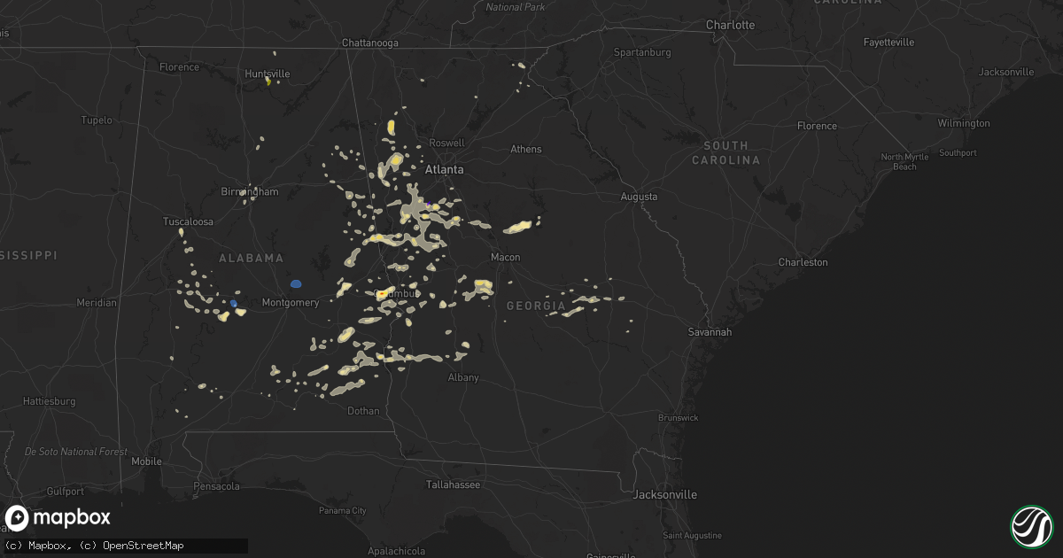
Hail Map in Georgia on June 15, 2022
Get this storm
June 15 map
$229
one time, instant access
Download today. No call, no setup
Keep the $229
Bought the map and want the full workflow? Apply the entire $229 to a subscription within 7 days. None of it is wasted.
Every map, not just this one
This buys you this map. Subscription and you get every map we run, in the markets you choose from a few cities to whole states to nationwide. Plus real-time alerts the moment a storm fires.
Contact data
Name, contact info, occupancy, even credit band for addresses in the footprint. You go from where it hit to who to call.
Become the source they trust
Unlimited branding weather history reports on demand. You already have the documented answer ready for the property owner, and you are the one who showed up with it.
Property data and RoofTrace estimates
Pull up any address you have got, its value and the exact code rules for that jurisdiction, straight from One Click Code. Then RoofTrace estimates the squares, pitch, and roof value, priced the way you price.
Storm reports in Georgia
Georgia
| Date | Description |
|---|---|
| 06/15/20226:55 PM CDT | Tree across the newnan road |
| 06/15/20226:52 PM CDT | Trees snapped in northern clay county. |
| 06/15/20226:52 PM CDT | Quarter-sized hail reported near willow ln. |
| 06/15/20226:51 PM CDT | Tree down across cheatham road |
| 06/15/20226:50 PM CDT | Multiple trees down |
| 06/15/20226:45 PM CDT | Multiple trees down |
| 06/15/20226:43 PM CDT | Structural roof damage to a business along broad st |
| 06/15/20226:43 PM CDT | Tree down across east maddox road |
| 06/15/20226:43 PM CDT | 20+ reports of trees and powerlines downed across roads in the city of griffin. North cherokee avenue to terrace street on the south side to spalding street on the east |
| 06/15/20226:42 PM CDT | Tree down on a house on maddox road |
| 06/15/20226:42 PM CDT | Tree on a house on day street |
| 06/15/20226:42 PM CDT | Tree down on a house along south 6th st |
| 06/15/20226:41 PM CDT | Tree on a house on daniel street |
| 06/15/20226:41 PM CDT | Tree down on a house on 6th street. Powerlines also downed. |
| 06/15/20226:40 PM CDT | Tree on a house along south mcdonough road |
| 06/15/20226:35 PM CDT | Trees down across swint road |
| 06/15/20226:35 PM CDT | Several trees reported down in the city of greenville |
| 06/15/20226:35 PM CDT | Numerous trees downed along bucksnort road along and up to the butts and spalding county line |
| 06/15/20226:34 PM CDT | Tree and powerlines down across high falls park rd near bell rd. |
| 06/15/20226:33 PM CDT | Tree down on a house along lakeshore drive |
| 06/15/20226:25 PM CDT | Roof blown off of a home on dromedary st. |
| 06/15/20226:22 PM CDT | 2 trees down |
| 06/15/20226:22 PM CDT | Tree down at the intersection of hwy 103 and goose creek rd. |
| 06/15/20226:22 PM CDT | Reports of 2 traffic lights blown off the pole at the intersection of 74 and 85. |
| 06/15/20226:22 PM CDT | Roof off a building in woodbury near cedar st. |
| 06/15/20226:20 PM CDT | Ema reporting over 300+ trees downed in and around jones mill road and flat shoals road. Radar confirms presence of downburst signature in the area. |
| 06/15/20226:20 PM CDT | 2 houses with trees on them along riggins ferry rd southeast of woodbury |
| 06/15/20226:20 PM CDT | Several trees reported down at the intersection of hwy 85 and main st. Traffic light blown off pole. |
| 06/15/20226:18 PM CDT | Multiple trees down along mt vernon church rd near intersection of mountain view rd |
| 06/15/20226:15 PM CDT | Multiple trees down |
| 06/15/20226:12 PM CDT | Roof off a structure along river cove road |
| 06/15/20226:12 PM CDT | Multiple trees down on 2 separate house along homestead cir |
| 06/15/20226:10 PM CDT | 2 trees down |
| 06/15/20226:05 PM CDT | Quarter-sized hail reported near maple dr and s 6th st in griffin. |
| 06/15/20225:57 PM CDT | Tree reported down at the intersection of hwy 116 and rd brown rd. |
| 06/15/20225:55 PM CDT | Tree down at the intersection of nelson rd and pleasant grove rd. |
| 06/15/20225:51 PM CDT | Tree reported down at the intersection of hwy 315 and old warm springs rd. |
| 06/15/20225:50 PM CDT | Quarter-sized hail reported near intersection of bo bo banks rd and allen rd. |
| 06/15/20225:49 PM CDT | Tree down at the intersection of ginn lake and ginn dr. |
| 06/15/20225:48 PM CDT | Multiple trees down near the intersection of harris rd and ginn dr |
| 06/15/20225:46 PM CDT | Tree reported down at the intersection of hwy 315 and old warm springs rd. |
| 06/15/20225:44 PM CDT | Tree reported down at the intersection of hwy 27 and lake lorraine dr. |
| 06/15/20225:41 PM CDT | Tree down near the intersection harris rd and ga-208 |
| 06/15/20225:40 PM CDT | Tree down at the intersection of ginn lake and ginn dr. |
| 06/15/20225:40 PM CDT | Multiple trees down near the intersection of harris rd and ginn dr |
| 06/15/20225:35 PM CDT | Quarter size hail reported in utapoi |
| 06/15/20225:33 PM CDT | Tree and powerline reported down at the intersection of s hwy 29 and oaklawn rd. |
| 06/15/20225:24 PM CDT | Approximately 650f homes in fort valley were without power per em. |
| 06/15/20225:23 PM CDT | Tree down on home with structural damage near the intersection of tower rd and wynnmeade pkwy |
| 06/15/20225:22 PM CDT | Tree reported down across the road on hwy 54 near intersection with sunset dr. |
| 06/15/20225:16 PM CDT | 1 inch hail observed on macintosh estates ct. |
| 06/15/20225:16 PM CDT | Multiple trees down near intersection of joel cowan pkwy and kelly dr |
| 06/15/20225:16 PM CDT | Half dollar size hail reported near intersection of driftwood ct and fishers luck. |
| 06/15/20225:16 PM CDT | Tree reported down in a yard on macintosh estates ct. |
| 06/15/20225:12 PM CDT | Quarter-sized hail reported near intersection of hwy 126 and johnny martin rd. |
| 06/15/20225:10 PM CDT | 1 inch hail observed at balmoral village near s peachtree pkwy. |
| 06/15/20225:10 PM CDT | 1 tree down |
| 06/15/20225:04 PM CDT | Quarter to ping pong ball-sized hail reported near intersection of southshore rd and twin bridges rd. |
| 06/15/20225:00 PM CDT | A tree fell on a house |
| 06/15/20225:00 PM CDT | Multiple trees down |
| 06/15/20223:56 PM CDT | Quarter-sized hail reported near intersection of county line rd and ethridge mill rd. |
| 06/15/20224:45 AM CDT | At 945 PM EDT, a severe thunderstorm was located over Buchanan, moving northwest at 20 mph. HAZARD...60 mph wind gusts and penny size hail. SOURCE...Radar indicated. IMPACT...Expect damage to roofs, siding, and trees. Locations impacted include... Buchanan, Bremen, Rockmart, Tallapoosa, Waco, Yorkville, Draketown, Eubank Lake and Van Wert. |
| 06/15/20224:07 AM CDT | At 907 PM EDT, a severe thunderstorm was located near Blackjack Mountain, or 12 miles southwest of Carrollton, moving northwest at 15 mph. HAZARD...60 mph wind gusts and quarter size hail. SOURCE...Radar indicated. IMPACT...Hail damage to vehicles is expected. Expect wind damage to roofs, siding, and trees. Locations impacted include... Bowdon, Ephesus, Tyus and Blackjack Mountain. |
| 06/15/20224:01 AM CDT | At 901 PM EDT, severe thunderstorms were located along a line extending from near Braswell to John Tanner State Park, moving northwest at 10 mph. HAZARD...60 mph wind gusts and quarter size hail. SOURCE...Radar indicated. IMPACT...Hail damage to vehicles is expected. Expect wind damage to roofs, siding, and trees. Locations impacted include... Carrollton, Dallas, Buchanan, Villa Rica, Bremen, Temple, Rockmart, Tallapoosa, Mount Zion, Waco, Braswell, Yorkville, Eubank Lake, Bowdon Junction, Van Wert, Abilene, Draketown, John Tanner State Park and New Georgia. |
| 06/15/20223:38 AM CDT | At 838 PM CDT, a severe thunderstorm was located over Georgetown, moving west at 15 mph. HAZARD...60 mph wind gusts. SOURCE...Radar indicated. IMPACT...Expect damage to roofs, siding, and trees. Locations impacted include... Eufaula, Clio, Clayton, Louisville, Hawkinsville, Gaino, Osco, Richards Crossroads, White Oak, Lakepoint Resort State Park, Boot Hill, Millers Ford, Clayton Municipal Airport, Twin Springs, Lugo and Baker Hill. |
| 06/15/20223:32 AM CDT | At 832 PM EDT, a severe thunderstorm was located near Clayton, or near Tiger, moving northwest at 15 mph. HAZARD...Quarter size hail. SOURCE...Radar indicated. IMPACT...Minor damage to vehicles is expected. Locations impacted include... Clayton, Mountain City, Tiger, Lake Rabun, Lake Burton, Lakemont, Black Rock Mountain State Park, Seed Lake and Tallulah Falls. |
| 06/15/20223:25 AM CDT | At 825 PM EDT, a severe thunderstorm was located near Kingston, or 9 miles east of Rome, moving north at 10 mph. HAZARD...60 mph wind gusts and quarter size hail. SOURCE...Radar indicated. IMPACT...Hail damage to vehicles is expected. Expect wind damage to roofs, siding, and trees. Locations impacted include... Rome, Euharlee, Kingston and Shannon. |
| 06/15/20223:04 AM CDT | At 804 PM EDT, a severe thunderstorm was located near Lone Oak, or 8 miles north of Greenville, moving west at 35 mph. HAZARD...60 mph wind gusts and quarter size hail. SOURCE...Radar indicated. IMPACT...Hail damage to vehicles is expected. Expect wind damage to roofs, siding, and trees. Locations impacted include... Newnan, LaGrange, Hogansville, Grantville, Luthersville, Moreland, Sharpsburg, Turin, Lone Oak, East Newnan, Corinth, Rocky Mount, Saint Marks, Louise, Powers Crossroads, Handy, Harrisonville, Hillcrest, Thomas Crossroads and Wooster. |
| 06/15/20222:41 AM CDT | At 741 PM EDT, a severe thunderstorm was located over Murrays Crossroads, or 7 miles north of Ellaville, moving southwest at 30 mph. HAZARD...60 mph wind gusts and quarter size hail. SOURCE...Radar indicated. IMPACT...Hail damage to vehicles is expected. Expect wind damage to roofs, siding, and trees. Locations impacted include... Buena Vista, Ellaville, Putnam, Brantley, Murrays Crossroads, Tazewell, Doyle, Fountainville, Rupert, Charing, Draneville and Walls Crossing. |
| 06/15/20222:39 AM CDT | At 739 PM EDT/639 PM CDT/, a severe thunderstorm was located 9 miles north of Fort Gaines, moving west at 10 mph. HAZARD...60 mph wind gusts and nickel size hail. SOURCE...Radar indicated. IMPACT...Expect damage to roofs, siding, and trees. Locations impacted include... Fort Gaines, Days Crossroads, Wire Bridge, Walter F George Lake, Bonapartes Retreat, Standleys Store, Otho, Watson Crossroads, Scottsboro Crossroads, Double Bridges, Moores Crossroads, Crossroads, Ricks Place, Garnersville, Screamer, Coates, Bagby State Park, Thomas Mill Creek, Hatcher and Morris. |
| 06/15/20222:33 AM CDT | At 733 PM EDT, a severe thunderstorm was located over Chappel Mill, or 8 miles east of Griffin, moving west at 35 mph. HAZARD...60 mph wind gusts and quarter size hail. SOURCE...Radar indicated. IMPACT...Hail damage to vehicles is expected. Expect wind damage to roofs, siding, and trees. Locations impacted include... Griffin, Zebulon, Peachtree City, Senoia, Milner, Brooks, Williamson, Sharpsburg, Turin, Orchard Hill, Haralson, Woolsey, Sunny Side, East Griffin, Starrs Mill, Walker Mill, Hollonville, Inman, Rover and Liberty Hill. |
| 06/15/20222:30 AM CDT | At 730 PM EDT, a severe thunderstorm was located near Leesburg, moving west at 10 mph. HAZARD...60 mph wind gusts and quarter size hail. SOURCE...Radar indicated. IMPACT...Hail damage to vehicles is expected. Expect wind damage to roofs, siding, and trees. Locations impacted include... Dawson, Leesburg, Smithville, Sasser, Bronwood, Parrott, Bridges Crossroad, Herod, Jordan Place, Yeomans, Clarks Mill, Dawson Municipal A/P, Starksville, Byne Crossroads, Graves, Scrutchins, Armena, Oakville, Chambliss and Olivers Mill. |
| 06/15/20222:30 AM CDT | At 730 PM EDT, a severe thunderstorm was located over Odessadale, or near Greenville, moving west at 25 mph. HAZARD...60 mph wind gusts and quarter size hail. SOURCE...Radar indicated. IMPACT...Hail damage to vehicles is expected. Expect wind damage to roofs, siding, and trees. Locations impacted include... LaGrange, Greenville, Manchester, Warm Springs, Raleigh, Mountville, Louise, Odessadale, Stovall, Big Springs, Durand, Baughs Crossroads, Harris City, Smiths Crossroad and Jones Crossroads. |
| 06/15/20222:22 AM CDT | At 722 PM EDT, a severe thunderstorm was located over Butler, moving southwest at 15 mph. HAZARD...60 mph wind gusts and quarter size hail. SOURCE...Radar indicated. IMPACT...Hail damage to vehicles is expected. Expect wind damage to roofs, siding, and trees. Locations impacted include... Butler, Howard, Wesley Church and Fickling Mill. |
| 06/15/20222:21 AM CDT | At 721 PM EDT, a severe thunderstorm was located over Handy, or 9 miles west of Newnan, moving west at 10 mph. HAZARD...60 mph wind gusts and quarter size hail. SOURCE...Radar indicated. IMPACT...Hail damage to vehicles is expected. Expect wind damage to roofs, siding, and trees. Locations impacted include... Franklin, Whitesburg, Centralhatchee, Roopville, Plant Yates, Lowell, Plant Wansley, Powers Crossroads and Handy. |
| 06/15/20222:11 AM CDT | At 711 PM EDT, a severe thunderstorm was located over Berner, or 9 miles southeast of Jackson, moving west at 10 mph. HAZARD...60 mph wind gusts and quarter size hail. SOURCE...Radar indicated. IMPACT...Hail damage to vehicles is expected. Expect wind damage to roofs, siding, and trees. Locations impacted include... Jackson, Flovilla, McElheneys Crossroads, Indian Springs State Park and Blount. |
| 06/15/20222:09 AM CDT | At 709 PM CDT, severe thunderstorms were located along a line extending from near Ephesus to Amity Park, moving west at 20 mph. HAZARD...60 mph wind gusts and quarter size hail. SOURCE...Radar indicated. IMPACT...Hail damage to vehicles is expected. Expect wind damage to roofs, siding, and trees. Locations impacted include... Valley, Lanett, Roanoke, Wedowee, Lafayette, Stroud, La Fayette, Wadley, Woodland, Waverly, Lakeview, Five Points, Cusseta, Malone, Post Oak Forks, Denson, River View, Amity Park, Sturkie and Abanda. |
| 06/15/20222:07 AM CDT | At 707 PM EDT, a severe thunderstorm was located over Crest, or 8 miles northwest of Thomaston, moving west at 10 mph. HAZARD...60 mph wind gusts and quarter size hail. SOURCE...Radar indicated. IMPACT...Hail damage to vehicles is expected. Expect wind damage to roofs, siding, and trees. Locations impacted include... Thomaston, Manchester, Woodbury, Molena, Sunset Village, Sprewell Bluff State Park, Crest, Sunnyside, Atwater, Lifsey Springs, Hannahs Mill and Imlac. |
| 06/15/20222:05 AM CDT | At 704 PM EDT, a severe thunderstorm was located over Hogansville, or 12 miles south of Newnan, moving southwest at 10 mph. HAZARD...60 mph wind gusts and quarter size hail. SOURCE...Radar indicated. IMPACT...Hail damage to vehicles is expected. Expect wind damage to roofs, siding, and trees. Locations impacted include... Hogansville, Grantville, Corinth, Louise and Harrisonville. |
| 06/15/20221:53 AM CDT | At 653 PM EDT, a severe thunderstorm was located over Marshallville, or 8 miles southwest of Fort Valley, moving southwest at 15 mph. HAZARD...60 mph wind gusts and quarter size hail. SOURCE...Radar indicated. IMPACT...Hail damage to vehicles is expected. Expect wind damage to roofs, siding, and trees. Locations impacted include... Fort Valley, Oglethorpe, Montezuma, Marshallville, Reynolds, Ideal, Saint Louis, Whitewater State Park, Nakomis, Meadowdale, Garden Valley, Hicks, Potterville, Clearview, Lee Pope, Winchester and Bartlett. |
| 06/15/20221:52 AM CDT | At 651 PM EDT, a severe thunderstorm was located over Chattahoochee Hills, or 12 miles north of Newnan, moving west at 5 mph. HAZARD...60 mph wind gusts and quarter size hail. SOURCE...Radar indicated. IMPACT...Hail damage to vehicles is expected. Expect wind damage to roofs, siding, and trees. Locations impacted include... Palmetto, Whitesburg, Chattahoochee Hills, Dunaway Gardens, Plant Yates, Byers Crossroads, Hannah, Roscoe, Fairplay and Bill Arp. |
| 06/15/20221:51 AM CDT | At 651 PM EDT, a severe thunderstorm was located over Walker Mill, or near Griffin, moving west at 15 mph. HAZARD...60 mph wind gusts and quarter size hail. SOURCE...Radar indicated. IMPACT...Hail damage to vehicles is expected. Expect wind damage to roofs, siding, and trees. Locations impacted include... Griffin, Orchard Hill, Sunny Side, East Griffin, Highland Mills, Rover, Towalaga, Experiment and Walker Mill. |
| 06/15/20221:45 AM CDT | At 645 PM EDT, a severe thunderstorm was located over Round Oak, or 9 miles northwest of Gray, moving west at 25 mph. HAZARD...60 mph wind gusts and quarter size hail. SOURCE...Radar indicated. IMPACT...Hail damage to vehicles is expected. Expect wind damage to roofs, siding, and trees. Locations impacted include... Forsyth, Bradley, Bolingbroke, Wayside, Hillsboro, Dames Ferry, Berner, Round Oak, Juliette, Plant Scherer and Jarrell Plantation. |
| 06/15/20221:41 AM CDT | At 641 PM EDT, a severe thunderstorm was located over East Newnan, or near Newnan, moving west at 5 mph. HAZARD...60 mph wind gusts and quarter size hail. SOURCE...Radar indicated. IMPACT...Hail damage to vehicles is expected. Expect wind damage to roofs, siding, and trees. Locations impacted include... Newnan, Grantville, Moreland and East Newnan. |
| 06/15/20221:18 AM CDT | At 618 PM CDT, severe thunderstorms were located along a line extending from River View to Columbus, moving west at 20 mph. HAZARD...60 mph wind gusts. SOURCE...Radar indicated. IMPACT...Expect damage to roofs, siding, and trees. Locations impacted include... Auburn, Phenix City, Opelika, Valley, Smiths, Smiths Station, Cusseta, Beulah, Beans Mill, River View, Beauregard, Sturkie, Bleecker, Chambers County Lake, Fairfax, Ladonia, Oak Bowery, Griffen Mill, Huguley and Bibb City. |
| 06/15/20221:17 AM CDT | At 617 PM EDT, a severe thunderstorm was located over Miami Valley, or near Fort Valley, moving northwest at 25 mph. HAZARD...60 mph wind gusts and quarter size hail. SOURCE...Radar indicated. IMPACT...Hail damage to vehicles is expected. Expect wind damage to roofs, siding, and trees. Locations impacted include... Fort Valley, Roberta, Byron, Reynolds, Knoxville, Nakomis, Powerville, Lee Pope, Horns, Miami Valley and Lakewood. |
| 06/15/20221:04 AM CDT | At 604 PM EDT, a severe thunderstorm was located over Peachtree City, or 8 miles southwest of Fayetteville, moving southwest at 10 mph. HAZARD...60 mph wind gusts and quarter size hail. SOURCE...Radar indicated. IMPACT...Hail damage to vehicles is expected. Expect wind damage to roofs, siding, and trees. Locations impacted include... Newnan, Peachtree City, Tyrone, Senoia, Brooks, Sharpsburg, Turin, Haralson, East Newnan, Starrs Mill and Thomas Crossroads. |
| 06/15/20221:01 AM CDT | At 601 PM EDT, a severe thunderstorm was located over Ethridge, or 11 miles south of Eatonton, moving southwest at 20 mph. HAZARD...60 mph wind gusts and quarter size hail. SOURCE...Radar indicated. IMPACT...Hail damage to vehicles is expected. Expect wind damage to roofs, siding, and trees. Locations impacted include... Milledgeville, Gray, Meriwether, Ethridge, Bradley, Wayside, Haddock, Resseaus Crossroads, Round Oak, Clinton, Plant Harlee Branch, Browns Crossing, Stanfordville and Blountsville. |
| 06/15/202212:47 AM CDT | At 546 PM EDT, a severe thunderstorm was located over Woodland, or 7 miles north of Talbotton, moving west at 15 mph. HAZARD...60 mph wind gusts and quarter size hail. SOURCE...Radar indicated. IMPACT...Hail damage to vehicles is expected. Expect wind damage to roofs, siding, and trees. Locations impacted include... Talbotton, Waverly Hall, Woodland, Pleasant Hill and Olive Branch. |
| 06/15/202212:43 AM CDT | At 543 PM CDT, a severe thunderstorm was located near Richards Crossroads, or 7 miles south of Eufaula, moving southwest at 10 mph. HAZARD...60 mph wind gusts and penny size hail. SOURCE...Radar indicated. IMPACT...Expect damage to roofs, siding, and trees. Locations impacted include... Richards Crossroads. |
| 06/15/202212:31 AM CDT | At 531 PM EDT, a severe thunderstorm was located over Soperton, moving west at 15 mph. HAZARD...60 mph wind gusts and quarter size hail. SOURCE...Radar indicated. IMPACT...Hail damage to vehicles is expected. Expect wind damage to roofs, siding, and trees. Locations impacted include... Soperton, Tarrytown, Lothair, Orland, Rockledge, Orianna, Barnhill, Kibbee, Minter, Lowery, Blackville, Zaidee and Gillis Springs. |
| 06/15/202212:19 AM CDT | At 519 PM EDT, a severe thunderstorm was located over Charles, or near Lumpkin, moving southwest at 10 mph. HAZARD...60 mph wind gusts and quarter size hail. SOURCE...Radar indicated. IMPACT...Hail damage to vehicles is expected. Expect wind damage to roofs, siding, and trees. Locations impacted include... Lumpkin, Charles, Louvale and Providence Canyon State Park. |
| 06/14/202211:27 PM CDT | At 427 PM EDT, a severe thunderstorm was located 12 miles southeast of Franklin, or near Highlands, moving southwest at 10 mph. HAZARD...60 mph wind gusts and quarter size hail. SOURCE...Radar indicated. IMPACT...Minor hail damage to vehicles is expected. Expect wind damage to trees and power lines. Locations impacted include... Highlands, Scaly Mountain, Whiteside Mountain, Lake Glenville, Otto and Pine Mountain. |
| 06/14/20228:50 PM CDT | Several trees downed in the city of buchanan |
| 06/14/20228:45 PM CDT | Tree down across old hwy 100 at walkers creek |
| 06/14/20228:45 PM CDT | 3 trees reported downed in the city of bremen |
| 06/14/20228:32 PM CDT | Tree down on steadham road |
| 06/14/20228:30 PM CDT | Delayed report of numerous trees down countywide. Time estimated by radar. |
| 06/14/20228:30 PM CDT | Several trees downed in the city of tallapoosa |
| 06/14/20228:20 PM CDT | Numerous trees down |
| 06/14/20228:15 PM CDT | A tree fell on a house |
| 06/14/20228:12 PM CDT | 1 tree fell on a mobile home |
| 06/14/20228:12 PM CDT | 1 tree fell on a house |
| 06/14/20228:10 PM CDT | Quarter size hail reported near intersection of pleasant ridge ch rd and ga-113 |
| 06/14/20227:50 PM CDT | Observed along east wolf creek road... Relayed through rabun co wx facebook page. |
| 06/14/20227:35 PM CDT | Pine mountain asos |
| 06/14/20227:30 PM CDT | Damage to multiple farm buildings including a shredded hay barn and roofs torn off barns. Partial roof damage to home. Multiple trees and powerlines down on/around prop |
| 06/14/20227:11 PM CDT | Trees reported down in the town of gay |
| 06/14/20227:10 PM CDT | Damage to multiple farm buildings including a shredded hay barn and roofs torn off barns. Partial roof damage to home. Multiple trees and powerlines down on/around prop |
All States Impacted by Hail Map on June 15, 2022
Cities Impacted by Hail Map on June 15, 2022
- Harmony, MN
- Scipio Center, NY
- Rib Lake, WI
- Medford, WI
- Wautoma, WI
- Neshkoro, WI
- Montello, WI
- Westfield, WI
- Oxford, WI
- Grand Marsh, WI
- Cottage Grove, WI
- Stoughton, WI
- Ishpeming, MI
- Champion, MI
- Theresa, WI
- Viroqua, WI
- Mayville, WI
- Lomira, WI
- Traverse City, MI
- Manchester, IA
- Greeley, IA
- La Valle, WI
- Nunda, NY
- Mount Morris, NY
- Piedmont, AL
- Birmingham, AL
- Tampico, IL
- Prophetstown, IL
- Rock Falls, IL
- Merrill, WI
- Brokaw, WI
- Wausau, WI
- Cascade, WI
- Plymouth, WI
- Sheboygan Falls, WI
- Waldo, WI
- Lanesboro, MN
- Preston, MN
- Chatham, MI
- Trenary, MI
- Twin Lake, MI
- Muskegon, MI
- Eckerman, MI
- Fayette, IA
- Mcfarland, WI
- Bristol, WI
- Kenosha, WI
- Heflin, AL
- Wedowee, AL
- Gowen, MI
- Trufant, MI
- Readstown, WI
- Viola, WI
- Dodgeville, WI
- Blue Mounds, WI
- Mount Horeb, WI
- Salem, IA
- Merrimac, WI
- Lodi, WI
- Portage, WI
- Pardeeville, WI
- North Freedom, WI
- Plain, WI
- Prairie Du Sac, WI
- Baraboo, WI
- Sauk City, WI
- Delta, AL
- Morrison, IL
- Fenton, IL
- Deerbrook, WI
- Two Rivers, WI
- Manitowoc, WI
- Eureka, IL
- Lima, NY
- Bellevue, IA
- Geneva, NY
- Romulus, NY
- Pearl City, IL
- Tiger, GA
- Cedartown, GA
- Rockmart, GA
- Aragon, GA
- Sumner, IA
- Antigo, WI
- Newberry, MI
- Paradise, MI
- Grawn, MI
- Wonewoc, WI
- Wisconsin Dells, WI
- Mauston, WI
- Hillsboro, WI
- Lyndon Station, WI
- Friendship, WI
- Adams, WI
- Kendall, WI
- Elroy, WI
- La Farge, WI
- Hermansville, MI
- Spalding, MI
- Escanaba, MI
- Wilson, MI
- Wells, MI
- Manistique, MI
- Bark River, MI
- Daggett, MI
- Wausaukee, WI
- Stephenson, MI
- Amberg, WI
- Wetmore, MI
- Cornell, MI
- Powers, MI
- Rapid River, MI
- Nahma, MI
- Carney, MI
- Gladstone, MI
- Nadeau, MI
- Vulcan, MI
- Weyauwega, WI
- Waupaca, WI
- Wild Rose, WI
- Pine River, WI
- Watertown, WI
- Blue River, WI
- Fennimore, WI
- Stitzer, WI
- Muscoda, WI
- Montfort, WI
- Avoca, WI
- Highland, WI
- Richland Center, WI
- Lone Rock, WI
- Mount Hope, WI
- Woodman, WI
- Boscobel, WI
- Lancaster, WI
- Bruce, WI
- Holcombe, WI
- Wilton, WI
- Tomah, WI
- Garnavillo, IA
- Patch Grove, WI
- Glen Haven, WI
- Guttenberg, IA
- Bloomington, WI
- Prairie Du Chien, WI
- Bagley, WI
- Gurley, AL
- Owens Cross Roads, AL
- Gays Mills, WI
- Anamosa, IA
- Monticello, IA
- Sterling, IL
- Novinger, MO
- Green Castle, MO
- Milan, MO
- Green City, MO
- Anniston, AL
- Disputanta, VA
- Petersburg, VA
- Mouth Of Wilson, VA
- Highlands, NC
- Maquoketa, IA
- Kent, IL
- Blountsville, AL
- Leaf River, IL
- Winnebago, IL
- Shannon, IL
- Lanark, IL
- Mount Carroll, IL
- Hudson, IN
- Wolcottville, IN
- Angola, IN
- Lagrange, IN
- Alexandria, AL
- Jacksonville, AL
- Wellington, AL
- Franklin, GA
- Marion, NC
- Hollister, NC
- Littleton, NC
- Lake Como, PA
- Starlight, PA
- Hankins, NY
- Callicoon, NY
- Long Eddy, NY
- Preston Park, PA
- Starrucca, PA
- Hancock, NY
- Lakewood, PA
- Damascus, PA
- Equinunk, PA
- Unionville, MO
- Worthington, MO
- Polo, MO
- Lathrop, MO
- Turney, MO
- Freeport, IL
- Ridott, IL
- Reidsville, GA
- Elba, AL
- Gainestown, AL
- Toccoa, GA
- Adrian, GA
- Swainsboro, GA
- Troy, AL
- Hamilton, GA
- Pine Mountain, GA
- Shiloh, GA
- Pine Mountain Valley, GA
- Lowell, WI
- Waterloo, WI
- Juneau, WI
- Marshall, WI
- Rio, WI
- Madison, WI
- Columbus, WI
- Waunakee, WI
- Deforest, WI
- Windsor, WI
- Reeseville, WI
- Beaver Dam, WI
- Sun Prairie, WI
- West Liberty, IA
- West Branch, IA
- Atalissa, IA
- Riverside, IA
- Hampton, GA
- Ozark, AL
- Midland City, AL
- Fort Rucker, AL
- Skipperville, AL
- Newville, AL
- Taylorsville, GA
- Kingston, GA
- Rome, GA
- Silver Creek, GA
- Faunsdale, AL
- Thomaston, GA
- Pittsview, AL
- Eufaula, AL
- Hurtsboro, AL
- Hatchechubbee, AL
- Dexter, GA
- Safford, AL
- Orrville, AL
- Brownsville, MN
- Box Springs, GA
- Glenwood, GA
- Red Level, AL
- Sparta, GA
- Milledgeville, GA
- West Point, GA
- Cataula, GA
- Dawson, GA
- Bronwood, GA
- Phenix City, AL
- Alma, MI
- Elwell, MI
- Saint Louis, MI
- Shepherd, MI
- Eastman, GA
- Tyler, AL
- Selma, AL
- Abbeville, AL
- Clopton, AL
- Clayton, AL
- Louisville, AL
- Notasulga, AL
- Auburn, AL
- La Crescent, MN
- Tipton, IA
- Concord, GA
- East Dublin, GA
- Waco, GA
- Bremen, GA
- Carrollton, GA
- Hartford, KS
- Olpe, KS
- Fort Valley, GA
- Downing, MO
- Lancaster, MO
- Cantril, IA
- Donnellson, IA
- Pulaski, IA
- Bloomfield, IA
- Farmington, IA
- Milton, IA
- Bonaparte, IA
- Memphis, MO
- Mount Sterling, IA
- Keosauqua, IA
- Cuthbert, GA
- Morris, GA
- Brantley, AL
- Luverne, AL
- Grantville, GA
- Brundidge, AL
- Washington, IA
- Ainsworth, IA
- Elma, IA
- Five Points, AL
- Lagrange, GA
- Ideal, GA
- Marshallville, GA
- Perry, GA
- Oglethorpe, GA
- Reynolds, GA
- Leslie, GA
- Smithville, GA
- Cascade, IA
- Worthington, IA
- Farley, IA
- Wapello, IA
- Mount Pleasant, IA
- Winfield, IA
- Morning Sun, IA
- Wayland, IA
- Oakville, IA
- Mediapolis, IA
- Olds, IA
- Yarmouth, IA
- Mount Union, IA
- Queen City, MO
- Roanoke Rapids, NC
- Bowdon, GA
- Dozier, AL
- Griffin, GA
- Fayetteville, GA
- Brooks, GA
- Mossville, IL
- Benson, IL
- Roanoke, IL
- Metamora, IL
- Peoria, IL
- Lowpoint, IL
- Princeville, IL
- Dunlap, IL
- Washburn, IL
- Flanagan, IL
- Minonk, IL
- Peoria Heights, IL
- El Paso, IL
- Edwards, IL
- Washington, IL
- Brimfield, IL
- East Peoria, IL
- Chillicothe, IL
- Poynette, WI
- Randolph, WI
- Arlington, WI
- Doylestown, WI
- Fall River, WI
- Morrisonville, WI
- Adairsville, GA
- Eatonton, GA
- Huntsville, AL
- Smiths Station, AL
- Camp Douglas, WI
- Warrens, WI
- Banks, AL
- Warm Springs, GA
- Lumpkin, GA
- Omaha, GA
- Cadwell, GA
- Shellman, GA
- Georgetown, GA
- Fort Gaines, GA
- Dublin, GA
- Luthersville, GA
- Clio, AL
- Hazleton, IA
- Dundee, IA
- Edgewood, IA
- Lamont, IA
- Winthrop, IA
- Independence, IA
- Strawberry Point, IA
- Aurora, IA
- Stanley, IA
- Lakemont, GA
- Buena Vista, GA
- Ellaville, GA
- Newnan, GA
- Woodland, AL
- Madison, KS
- Springville, IA
- Central City, IA
- Muscatine, IA
- Elizabeth, IL
- Kingston, MO
- Ariton, AL
- Stockbridge, GA
- Jonesboro, GA
- Monroeville, AL
- Pinckney, MI
- Gregory, MI
- Jackson, MI
- Munith, MI
- Grass Lake, MI
- Whitmore Lake, MI
- Chelsea, MI
- Stockbridge, MI
- Dexter, MI
- Rives Junction, MI
- Pleasant Lake, MI
- Richmond, MO
- Marion, AL
- Repton, AL
- Port Charlotte, FL
- Johnson Creek, WI
- Lake Mills, WI
- Jefferson, WI
- Davenport, IA
- Blue Grass, IA
- Bettendorf, IA
- Woodbury, GA
- Molena, GA
- Leesburg, GA
- Orland, IN
- Fremont, IN
- Lawrence, KS
- Salem, AL
- Seale, AL
- Sperry, IA
- Hogansville, GA
- Palmetto, GA
- Lanett, AL
- Douglasville, GA
- Moreland, GA
- Zebulon, GA
- Lafayette, AL
- Williamson, GA
- Manchester, GA
- Senoia, GA
- Whitesburg, GA
- Milner, GA
- Greenville, GA
- Peachtree City, GA
- Fairburn, GA
- Sharpsburg, GA
- Gay, GA
- Meansville, GA
- Buchanan, GA
- Dallas, GA
- Temple, GA
- Villa Rica, GA
- Osage City, KS
- Durant, IA
- Crawfordsville, IA
- Donahue, IA
- Wilton, IA
- Columbus Junction, IA
- Dixon, IA
- Letts, IA
- Nichols, IA
- Eldridge, IA
- Walcott, IA
- Long Grove, IA
- Columbus City, IA
- Conesville, IA
- Stockton, IA
- Opelika, AL
- Gallion, AL
- Greensboro, AL
- Atmore, AL
- Columbus, GA
- Midland, GA
- Upatoi, GA
- Woodland, GA
- Fort Benning, GA
- Midway, AL
- Frisco City, AL
- Murphy, NC
- Marble, NC
- Charles City, IA
- Talbotton, GA
- Alamo, GA
- Sardis, AL
- Ithaca, NY
- Brooktondale, NY
- Tuskegee, AL
- Lost Nation, IA
- Grand Mound, IA
- Spragueville, IA
- Miles, IA
- Delmar, IA
- Charlotte, IA
- Wheatland, IA
- Preston, IA
- Congerville, IL
- Secor, IL
- Gridley, IL
- Haddock, GA
- Brighton, IA
- Lone Tree, IA
- Iowa City, IA
- Mcdonough, GA
- Hanover, IL
- Powder Springs, GA
- Minter, AL
- Iowa Falls, IA
- Warren, IL
- Apple River, IL
- Stockton, IL
- Fruithurst, AL
- East Bethany, NY
- Pavilion, NY
- Wyoming, NY
- Canton, MN
- Plattsburg, MO
- Marshall, MI
- Bellevue, MI
- Battle Creek, MI
- Smithville, MO
- Catawissa, PA
- Danville, PA
- Glenwood, AL
- Marion Junction, AL
- Coleman, GA
- Roanoke, AL
- Flovilla, GA
- Jackson, GA
- Forsyth, GA
- Livonia, NY
- Hemlock, NY
- Hayesville, NC
- Clarkdale, GA
- Austell, GA
- Kansas City, MO
- Platte City, MO
- Owego, NY
- Newark Valley, NY
- Endicott, NY
- Caledonia, MN
- Mechanicsville, VA
- Woodstock, IL
- Mount Airy, GA
- Pecatonica, IL
- Opp, AL
- Soperton, GA
- Tarrytown, GA
- Rockledge, GA
- Newbern, AL
- Fort Mitchell, AL
- Vidalia, GA
- Ellerslie, GA
- Thomasville, AL
- Grove Hill, AL
- Dickinson, AL
- Moundville, AL
- Wadley, AL
- Union Springs, AL
- King William, VA
- Savanna, IL
- Sabula, IA
- Warsaw, NY
- Humphreys, MO
- Galt, MO
- Laredo, MO
- Forreston, IL
- Chadwick, IL
- Milledgeville, IL
- Polo, IL
- Tuscaloosa, AL
- Fosters, AL
- Warner Robins, GA
- Cowgill, MO
- Braymer, MO
- Hamilton, MO
- Kahoka, MO
- Wyaconda, MO
- Rutledge, MO
- Greentop, MO
- Luray, MO
- Arbela, MO
- Saint Patrick, MO
- Gorin, MO
- Lyons, GA
- Hiram, GA
- Greenville, AL
- Acworth, GA
- Marietta, GA
- Kennesaw, GA
- Oxford, AL
- Magnolia, AL
- Pine Hill, AL
- Little River, AL
- Colwell, IA
- Cresco, IA
- Ridgeway, IA
- Lime Springs, IA
- Alta Vista, IA
- Orchard, IA
- New Hampton, IA
- Riceville, IA
- Elko, GA
- De Soto, WI
- Genoa, WI
- Spring Grove, MN
- Mabel, MN
- Decorah, IA
- Muscadine, AL
- Neosho, WI
- Ladysmith, WI
- Vestaburg, MI
- Lakeview, MI
- Riverdale, MI
- Stanton, MI
- Breckenridge, MI
- Edmore, MI
- New Market, AL
- Silver Springs, NY
- Helenville, WI
- Fort Atkinson, WI
- Cambridge, WI
- Camanche, IA
- Cordova, IL
- Collins, GA
- Tuskegee Institute, AL
- Goose Lake, IA
- Clinton, IA
- De Witt, IA
- Cayuta, NY
- Horseheads, NY
- Millport, NY
- Montour Falls, NY
- Newfield, NY
- Odessa, NY
- Alpine, NY
- Palmetto, FL
- Parrish, FL
- Wimauma, FL
- Ruskin, FL
- Bennett, IA
- Myakka City, FL
- Thomaston, AL
- Catherine, AL
- Uniontown, AL
- Butler, GA
- Metter, GA
- Ackley, IA
- Hampton, IA
- Coon Valley, WI
- Mauk, GA
- Ferryville, WI
- Winston, GA
- Emporia, KS
- Neosho Rapids, KS
- Leicester, NY
- Perry, NY
- Ontario, WI
- Dahlonega, GA
- Graham, AL
- Hanover, VA
- Manquin, VA
- Nebo, NC
- Kearney, MO
- Liberty, MO
- Jack, AL
- Cusseta, GA
- Sarasota, FL
- Union Springs, NY
- Aurora, NY
- Ovid, NY
- Norwalk, WI
- Harvard, IL
- Hebron, IL
- Erie, IL
- Albany, IL
- Tallapoosa, GA
- Stockport, IA
- Ionia, IA
- West Salem, WI
- Sparta, WI
- Little Cedar, IA
- Osage, IA
- Spring Valley, MN
- McIntire, IA
- Stoddard, WI
- Rockwell, IA
- Sheffield, IA
- Thornton, IA
- Le Roy, MN
- Wykoff, MN
- Rudd, IA
- Nora Springs, IA
- Mason City, IA
- La Crosse, WI
- Cashton, WI
- Swaledale, IA
- Rockford, IA
- Eitzen, MN
- Rockland, WI
- Floyd, IA
- Ostrander, MN
- Chester, IA
- Hokah, MN
- Bangor, WI
- Chaseburg, WI
- Necedah, WI
- Dorchester, IA
- Peterson, MN
- Rushford, MN
- Houston, MN
- Attica, NY
- Ellijay, GA
- Chatsworth, GA
- Atlanta, GA
- Enterprise, AL
- New Brockton, AL
- Bay City, MI
- Hillsboro, IA
- Birmingham, IA
- Waverly, AL
- Camp Hill, AL
- Grady, AL
- Glenwood, MO
- Coatsville, MO
- Ixonia, WI
- Oconomowoc, WI
- Edgerton, WI
- Sullivan, WI
- Ceresco, MI
- Castalia, NC
- Nashville, NC
- Clayton, GA
- Clarkesville, GA
- Hardaway, AL
- Waupun, WI
- Fox Lake, WI
- Burnett, WI
- Cambria, WI
- Dane, WI
- Clyman, WI
- Deerfield, WI
- Middleton, WI
- Verona, WI
- Horicon, WI
- Iron Ridge, WI
- Hustisford, WI
- Dansville, NY
- Bradenton, FL
- Monticello, GA
- Unadilla, GA
- Hawkinsville, GA
- Jesup, IA
- Hayden, AL
- Walton, NY
- Chillicothe, MO
- Fairfield, AL
- Saint Paul, IA
- West Point, IA
- Pollock, MO
- Livonia, MO
- Bostic, NC
- Chester, VA
- Chesterfield, VA
- Shullsburg, WI
- Darlington, WI
- Mineral Point, WI
- Berkshire, NY
- Wauzeka, WI
- New London, IA
- Hillsboro, GA
- Gray, GA
- Virgil, KS
- Hamilton, KS
- Eureka, KS
- Jones, AL
- Arlington, IA
- Fulton, IL
- Plains, GA
- Bradford, IA
- Lawler, IA
- Westby, WI
- Dakota, MN
- Elmore, AL
- Wetumpka, AL
- Manawa, WI
- Shiocton, WI
- Bonduel, WI
- Pulaski, WI
- Fremont, WI
- New London, WI
- Black Creek, WI
- Seymour, WI
- Wittenberg, WI
- Bowler, WI
- Tigerton, WI
- Crivitz, WI
- Oneida, WI
- New Lisbon, WI
- Redgranite, WI
- Appleton, WI
- Suamico, WI
- Brussels, WI
- Winneconne, WI
- Green Bay, WI
- Berlin, WI
- Sturgeon Bay, WI
- Hancock, WI
- Poy Sippi, WI
- Hortonville, WI
- Neenah, WI
- New Franken, WI
- Princeton, WI
- Greenville, WI
- Luxemburg, WI
- Kaukauna, WI
- De Pere, WI
- Coloma, WI
- Larsen, WI
- Stevens Point, WI
- Rudolph, WI
- Eland, WI
- Wisconsin Rapids, WI
- Hatley, WI
- Custer, WI
- Rosholt, WI
- Iola, WI
- Friesland, WI
- Wyocena, WI
- Amherst, WI
- Almond, WI
- Clintonville, WI
- Scandinavia, WI
- Oconto, WI
- Little Suamico, WI
- Krakow, WI
- Oconto Falls, WI
- Marinette, WI
- Sobieski, WI
- Abrams, WI
- Lena, WI
- Ogdensburg, WI
- Peshtigo, WI
- Bear Creek, WI
- Nichols, WI
- Fountain, MN
- Elkport, IA


