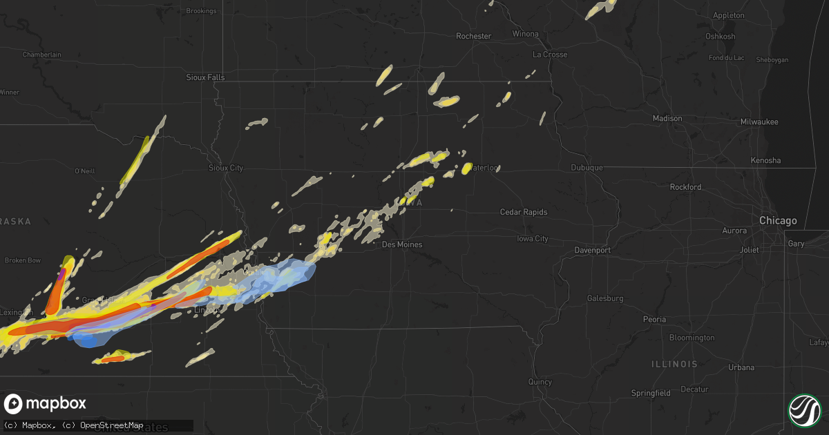
Hail Map in Iowa on June 14, 2022
Get this storm
June 14 map
$229
one time, instant access
Download today. No call, no setup
Keep the $229
Bought the map and want the full workflow? Apply the entire $229 to a subscription within 7 days. None of it is wasted.
Every map, not just this one
This buys you this map. Subscription and you get every map we run, in the markets you choose from a few cities to whole states to nationwide. Plus real-time alerts the moment a storm fires.
Contact data
Name, contact info, occupancy, even credit band for addresses in the footprint. You go from where it hit to who to call.
Become the source they trust
Unlimited branding weather history reports on demand. You already have the documented answer ready for the property owner, and you are the one who showed up with it.
Property data and RoofTrace estimates
Pull up any address you have got, its value and the exact code rules for that jurisdiction, straight from One Click Code. Then RoofTrace estimates the squares, pitch, and roof value, priced the way you price.
Storm reports in Iowa
Iowa
| Date | Description |
|---|---|
| 06/14/20226:39 AM CDT | At 1139 PM CDT, a severe thunderstorm was located over Louisville, or 9 miles south of Gretna, moving east at 30 mph. HAZARD...60 mph wind gusts and quarter size hail. SOURCE...Radar indicated. IMPACT...Hail damage to vehicles is expected. Expect wind damage to roofs, siding, and trees. This severe thunderstorm will be near... Springfield around 1145 PM CDT. Cedar Creek around 1150 PM CDT.Other locations in the path of this severe thunderstorm includeBellevue, Offutt AFB, Murray, Beaver Lake, Plattsmouth, PacificJunction and Glenwood.This includes the following highways... Interstate 29 between mile markers 12 and 54. Interstate 80 in Iowa between mile markers 1 and 8. Interstate 80 in Nebraska between mile markers 415 and 454. |
| 06/14/20226:21 AM CDT | At 1121 PM CDT, a severe thunderstorm was located near Gilbert, or near Ames, moving northeast at 35 mph. HAZARD...60 mph wind gusts and quarter size hail. SOURCE...Radar indicated. IMPACT...Hail damage to vehicles is expected. Expect wind damage to roofs, siding, and trees. This severe thunderstorm will be near... Roland around 1130 PM CDT. McCallsburg around 1135 PM CDT.Other locations in the path of this severe thunderstorm includeZearing, Radcliffe, Garden City, Drake Airport, Hubbard and NewProvidence.This includes Interstate 35 between mile markers 111 and 128. |
| 06/14/20225:38 AM CDT | At 1037 PM CDT, a severe thunderstorm was located 7 miles northeast of Iowa Falls, moving northeast at 35 mph. HAZARD...60 mph wind gusts and half dollar size hail. SOURCE...Radar indicated. IMPACT...Hail damage to vehicles is expected. Expect wind damage to roofs, siding, and trees. This severe thunderstorm will be near... Ackley, Geneva and Ackley Municipal Airport around 1045 PM CDT. Hansell around 1050 PM CDT.Other locations in the path of this severe thunderstorm includeAplington, Dumont, Bristow, Allison and Allison Municipal Airport. |
| 06/14/20225:29 AM CDT | At 1029 PM CDT, a severe thunderstorm was located 14 miles northeast of Atlantic, moving northeast at 35 mph. HAZARD...60 mph wind gusts and quarter size hail. SOURCE...Radar indicated. IMPACT...Hail damage to vehicles is expected. Expect wind damage to roofs, siding, and trees. This severe thunderstorm will be near... Adair around 1040 PM CDT.Other locations in the path of this severe thunderstorm includeGuthrie Center, Panora, Lake Panorama and Springbrook State Park.This includes Interstate 80 between mile markers 62 and 79. |
| 06/14/20225:10 AM CDT | At 1010 PM CDT, a severe thunderstorm was located over Oakland, or 20 miles northwest of Red Oak, moving northeast at 35 mph. HAZARD...60 mph wind gusts and quarter size hail. SOURCE...Radar indicated. IMPACT...Hail damage to vehicles is expected. Expect wind damage to roofs, siding, and trees. This severe thunderstorm will remain over mainly rural areas of southeastern Pottawattamie County. |
| 06/14/20224:58 AM CDT | At 958 PM CDT, a severe thunderstorm was located 10 miles west of Iowa Falls, moving northeast at 35 mph. HAZARD...60 mph wind gusts and half dollar size hail. SOURCE...Radar indicated. IMPACT...Hail damage to vehicles is expected. Expect wind damage to roofs, siding, and trees. This severe thunderstorm will be near... Iowa Falls around 1015 PM CDT.Other locations in the path of this severe thunderstorm includeBradford, Hampton Municipal Airport, Hampton, Geneva and Hansell.This includes Interstate 35 between mile markers 138 and 162. |
| 06/14/20224:42 AM CDT | At 942 PM CDT, a severe thunderstorm was located near Elliott, or 17 miles southwest of Atlantic, moving northeast at 45 mph. HAZARD...70 mph wind gusts and half dollar size hail. SOURCE...Radar indicated. IMPACT...Hail damage to vehicles is expected. Expect considerable tree damage. Wind damage is also likely to mobile homes, roofs, and outbuildings. This severe thunderstorm will be near... Griswold and Griswold Park around 950 PM CDT. Lewis and Cold Springs State Park around 955 PM CDT.Other locations in the path of this severe thunderstorm includeAtlantic, Cumberland, Atlantic Municipal Airport, Wiota, Anita, LakeAnita State Park and Anita Municipal Airport.This includes Interstate 80 between mile markers 59 and 71. |
| 06/14/20224:39 AM CDT | At 939 PM CDT, a severe thunderstorm was located 6 miles east of Carson, or 13 miles north of Red Oak, moving northeast at 30 mph. HAZARD...70 mph wind gusts and half dollar size hail. SOURCE...Radar indicated. IMPACT...Hail damage to vehicles is expected. Expect considerable tree damage. Wind damage is also likely to mobile homes, roofs, and outbuildings. This severe thunderstorm will be near... Elliott around 950 PM CDT. |
| 06/14/20224:07 AM CDT | At 907 PM CDT, a severe thunderstorm was located 4 miles northwest of Hastings, or 17 miles west of Red Oak, moving northeast at 30 mph. HAZARD...Golf ball size hail and 60 mph wind gusts. SOURCE...Radar indicated. IMPACT...People and animals outdoors will be injured. Expect hail damage to roofs, siding, windows, and vehicles. Expect wind damage to roofs, siding, and trees. This severe thunderstorm will be near... Henderson around 925 PM CDT.Other locations in the path of this severe thunderstorm includeCarson, Macedonia and Elliott. |
| 06/14/20223:00 AM CDT | Strong winds also reported. Relayed by kwwl tv. |
| 06/14/20222:40 AM CDT | Measured at the marshalltown airport. |
| 06/14/20222:28 AM CDT | Trees down. |
| 06/14/20222:19 AM CDT | Multiple trees down... Roof damage with strong winds. Time estimated via radar. |
| 06/14/202212:54 AM CDT | Report of large tree on vehicle. Time estimate via radar. |
| 06/14/202212:46 AM CDT | A local report indicates 70 MPH wind near ELLIOTT |
| 06/14/202212:40 AM CDT | Power lines down. Power out in town. Structural damage to one business. Debris in streets. |
| 06/14/202212:40 AM CDT | A local report indicates 70 MPH wind near 6 W ELLIOTT |
| 06/14/202212:35 AM CDT | From facebook. |
| 06/14/202212:35 AM CDT | Large trees down in the wheeler grove township. |
| 06/14/202212:30 AM CDT | 1 inch trees snapped. |
| 06/14/202212:27 AM CDT | Substantial damage to a farmstead. Grain bins destroyed. Other buildings blown off foundation. |
| 06/14/202212:25 AM CDT | 6 inch tree limb blown down... Blocking road. |
| 06/14/202212:25 AM CDT | 8 to 10 large trees snapped. Significant damage to a home and outbuilding. Time estimated based on radar. |
| 06/14/202212:20 AM CDT | Report from mping: 1-inch tree limbs broken; shingles blown off. |
| 06/14/202212:20 AM CDT | A local report indicates 60 MPH wind near TREYNOR |
| 06/14/202212:18 AM CDT | A local report indicates 90 MPH wind near SILVER CITY |
| 06/14/202212:16 AM CDT | A local report indicates 75 MPH wind near 5 ENE COUNCIL BLUFFS |
| 06/14/202212:12 AM CDT | Power lines down. Power out in glenwood. |
| 06/14/202212:10 AM CDT | A local report indicates 65 MPH wind near 4 NW SILVER CITY |
| 06/13/202211:23 PM CDT | Report via social media. I-35 rest area south bound. Time estimated by radar. |
| 06/13/202211:08 PM CDT | A local report indicates 1.00 inch wind near 5 NW APLINGTON |
| 06/13/20229:29 PM CDT | At 229 AM CDT, a severe thunderstorm was located over Vermillion, moving northeast at 50 mph. HAZARD...60 mph wind gusts. SOURCE...Radar indicated. IMPACT...Expect damage to roofs, siding, and trees. This severe thunderstorm will be near... Union Grove State Park around 245 AM CDT.Other locations in the path of this severe thunderstorm includeBeresford, Hawarden and Alcester. |
| 06/13/20229:20 PM CDT | Relayed via broadcast media. Picture of hail larger than a quarter. Time estimated from radar. |
All States Impacted by Hail Map on June 14, 2022
Cities Impacted by Hail Map on June 14, 2022
- Waskish, MN
- Big Falls, MN
- Minocqua, WI
- Granville, IA
- Orange City, IA
- Alton, IA
- Archer, IA
- Hospers, IA
- Ewing, NE
- Kabetogama, MN
- Littlefork, MN
- French Creek, WV
- Ames, IA
- Nevada, IA
- Kelley, IA
- Tallmansville, WV
- Thief River Falls, MN
- Orr, MN
- Lumber City, GA
- Camilla, GA
- Sale City, GA
- Frost, MN
- Buffalo Center, IA
- Bricelyn, MN
- Elmore, MN
- Wells, MN
- Wausau, WI
- Spring Grove, MN
- Dow City, IA
- Caledonia, MN
- Nashua, IA
- Charles City, IA
- Woodward, IA
- Boone, IA
- Adel, IA
- Minburn, IA
- Madrid, IA
- Redfield, IA
- Story City, IA
- Rippey, IA
- Gilbert, IA
- Panora, IA
- Perry, IA
- Ogden, IA
- Dallas Center, IA
- Yale, IA
- Luther, IA
- Linden, IA
- Dawson, IA
- Bouton, IA
- Millville, MN
- Grygla, MN
- Reinbeck, IA
- Cedar Falls, IA
- Dike, IA
- North Loup, NE
- Vienna, MD
- Mardela Springs, MD
- Coon Rapids, IA
- Durand, WI
- Menomonie, WI
- Cusseta, AL
- Valley, AL
- Lanett, AL
- Wolbach, NE
- Scotia, NE
- Greeley, NE
- Plummer, MN
- Oklee, MN
- Erskine, MN
- Mcintosh, MN
- Yuma, CO
- Venango, NE
- Ogallala, NE
- Grant, NE
- East Grand Forks, MN
- Warren, MN
- Parkersburg, IA
- Webster City, IA
- Marshall, NC
- Andrews, SC
- Nesmith, SC
- Hogansville, GA
- Decorah, IA
- Osage, IA
- Rudd, IA
- Plymouth, IA
- Mason City, IA
- Orchard, IA
- Nora Springs, IA
- Lac Du Flambeau, WI
- Thompson, ND
- Fisher, MN
- Thompson, IA
- Lake Mills, IA
- Scarville, IA
- Elcho, WI
- Pittsville, WI
- Black River Falls, WI
- Marshfield, WI
- Arpin, WI
- Warrens, WI
- Casey, IA
- Adair, IA
- Arcadia, NE
- Loup City, NE
- Lincoln, NE
- Walton, NE
- Greenville, GA
- Lagrange, GA
- Wellsburg, IA
- Holland, IA
- Grundy Center, IA
- Scribner, NE
- West Point, NE
- Rockwell City, IA
- Kelliher, MN
- Iowa Falls, IA
- Kesley, IA
- Allison, IA
- Williams, IA
- Hampton, IA
- Dumont, IA
- Dows, IA
- Popejoy, IA
- Aplington, IA
- Alden, IA
- Ackley, IA
- Bradford, IA
- Geneva, IA
- International Falls, MN
- Crookston, MN
- Beltrami, MN
- Ute, IA
- Charter Oak, IA
- Junction City, WI
- Auburndale, WI
- Milladore, WI
- Vesper, WI
- Mosinee, WI
- Merrill, WI
- North, SC
- Newport News, VA
- Tryon, NE
- Colfax, WI
- Elk Mound, WI
- Bovey, MN
- Deerbrook, WI
- Gleason, WI
- Blairsburg, IA
- Cambridge, MD
- Trail, MN
- Gully, MN
- Gonvick, MN
- Goodridge, MN
- Clearbrook, MN
- Neligh, NE
- Clearwater, NE
- Plainview, NE
- Mission Hill, SD
- Utica, SD
- Brunswick, NE
- Center, NE
- Creighton, NE
- Bloomfield, NE
- Crofton, NE
- Yankton, SD
- Royal, NE
- Irene, SD
- Ridgeway, IA
- Lake City, MN
- Wabasha, MN
- Wray, CO
- Holyoke, CO
- Oakwood, GA
- Gainesville, GA
- Waucoma, IA
- Fort Atkinson, IA
- Protivin, IA
- Calmar, IA
- Newfolden, MN
- Dupree, SD
- Champion, NE
- Dahlonega, GA
- Crawfordville, GA
- Denton, NE
- De Witt, NE
- Mabie, WV
- Pickens, WV
- Huttonsville, WV
- Mill Creek, WV
- Pacific Junction, IA
- Cleveland, GA
- Monterville, WV
- Slatyfork, WV
- Valley Head, WV
- Webster Springs, WV
- Marlinton, WV
- Brooklet, GA
- Red Lake Falls, MN
- Monona, IA
- Sac City, IA
- Lake View, IA
- Wall Lake, IA
- Odebolt, IA
- Kiron, IA
- Lytton, IA
- Marshalltown, IA
- Harlan, IA
- Kirkman, IA
- Manilla, IA
- Earling, IA
- Irwin, IA
- Defiance, IA
- New Providence, IA
- Moorefield, NE
- Shell Rock, IA
- New Hampton, IA
- Ionia, IA
- Hallam, NE
- Warrenton, GA
- Hooper, NE
- Uehling, NE
- Oakland, NE
- Talbotton, GA
- Woodland, GA
- Leary, GA
- Morgan, GA
- Edison, GA
- Lyle, MN
- Saint Ansgar, IA
- Northwood, IA
- Kensett, IA
- Grafton, IA
- Austin, MN
- Norman Park, GA
- Sylvania, GA
- Elko, GA
- Eastman, GA
- Cochran, GA
- Kathleen, GA
- Dry Branch, GA
- Hawkinsville, GA
- Perry, GA
- Jeffersonville, GA
- Blackduck, MN
- Blue Hill, NE
- Carleton, NE
- Red Cloud, NE
- Guide Rock, NE
- Deweese, NE
- Edgar, NE
- Davenport, NE
- Bladen, NE
- Oak, NE
- Nelson, NE
- Lawrence, NE
- Bruning, NE
- Tallahassee, FL
- Lyons, GA
- Letohatchee, AL
- Fort Deposit, AL
- Hayneville, AL
- Kermit, TX
- Albany, GA
- Sylvester, GA
- Doerun, GA
- Pleasant Dale, NE
- Milford, NE
- Malvern, IA
- Glenwood, IA
- Snow Hill, MD
- Alapaha, GA
- Fountain, FL
- Flowery Branch, GA
- Waynesboro, GA
- Cartersville, GA
- Williston, SC
- Millen, GA
- Smithfield, WV
- Windsor, SC
- Blackville, SC
- Oakland, IA
- Henderson, IA
- Carson, IA
- Macedonia, IA
- Silver City, IA
- Treynor, IA
- Baxley, GA
- Omega, GA
- Columbia, AL
- Headland, AL
- Ashford, AL
- Butler, GA
- Chula, GA
- Tifton, GA
- Council Bluffs, IA
- Junction City, GA
- Wink, TX
- Fremont, NE
- Bruno, NE
- Hampton, NE
- Bradshaw, NE
- Polk, NE
- Aurora, NE
- Bellwood, NE
- North Bend, NE
- Abie, NE
- Herman, NE
- David City, NE
- Benedict, NE
- Osceola, NE
- Rising City, NE
- Arlington, NE
- Ames, NE
- Winslow, NE
- Stromsburg, NE
- Morse Bluff, NE
- Linwood, NE
- Nickerson, NE
- Shelby, NE
- Liebenthal, KS
- Ness City, KS
- McCracken, KS
- Bazine, KS
- La Crosse, KS
- Alexander, KS
- Bison, KS
- Grand Island, NE
- Lexington, NE
- Overton, NE
- Eldora, IA
- Hubbard, IA
- Bertrand, NE
- Plattsmouth, NE
- Louisville, NE
- Weeping Water, NE
- Griswold, IA
- Emerson, IA
- Garland, NE
- Seward, NE
- Beatrice, NE
- Wood River, NE
- Valparaiso, NE
- Raymond, NE
- Malcolm, NE
- Weston, NE
- Prague, NE
- Mason City, NE
- Pleasanton, NE
- Doniphan, NE
- Trumbull, NE
- Heartwell, NE
- Kenesaw, NE
- Henderson, NE
- Gretna, NE
- Eustis, NE
- Bee, NE
- Fort Calhoun, NE
- Missouri Valley, IA
- Omaha, NE
- Bennet, NE
- Neeses, SC
- Banks, AL
- McRae Helena, GA
- Alamo, GA
- Hardaway, AL
- Ambrose, GA
- Douglas, GA
- Maywood, NE
- Curtis, NE
- Brayton, IA
- Anita, IA
- Atlantic, IA
- Elwood, NE
- Arapahoe, NE
- Smithfield, NE
- Moorland, IA
- Somers, IA
- Phillips, NE
- Saint Hilaire, MN
- Sumner, NE
- Aiken, SC
- Beaver Crossing, NE
- Dorchester, NE
- Friend, NE
- Quantico, MD
- Delmar, MD
- Linkwood, MD
- Hebron, MD
- Fruitland, MD
- East New Market, MD
- Rhodesdale, MD
- Salisbury, MD
- Delmar, DE
- Parsonsburg, MD
- Dillard, GA
- Statesboro, GA
- Troy, AL
- Vidalia, GA
- Woodbury, GA
- Warm Springs, GA
- Manchester, GA
- Moultrie, GA
- Sumner, GA
- Pine Grove, WV
- Kearney, NE
- Minden, NE
- Axtell, NE
- Sutton, NE
- York, NE
- Bethesda, OH
- Barnesville, OH
- Quaker City, OH
- Ravenna, NE
- Kennard, NE
- Hastings, NE
- Lebanon, NE
- Blair, NE
- McClelland, IA
- Litchfield, NE
- Funk, NE
- Oxford, NE
- Brainard, NE
- Holdrege, NE
- Bellevue, NE
- Mead, NE
- Edison, NE
- Elmwood, NE
- Washington, NE
- Ceresco, NE
- Crescent, IA
- Danbury, NE
- Grand Junction, IA
- Waverly, NE
- Bennington, NE
- Hazard, NE
- Holbrook, NE
- Alvo, NE
- Ashton, NE
- Papillion, NE
- Inland, NE
- Marquette, NE
- Fairmont, NE
- Ulysses, NE
- Mineola, IA
- Atlanta, NE
- Jefferson, IA
- Dwight, NE
- Manley, NE
- South Bend, NE
- Waco, NE
- Eagle, NE
- Saronville, NE
- Craig, NE
- Bayard, IA
- Waterloo, NE
- Loomis, NE
- Holstein, NE
- Harvard, NE
- Riverdale, NE
- Clay Center, NE
- Hamlin, IA
- Malmo, NE
- Bagley, IA
- Murray, NE
- Elliott, IA
- Cedar Bluffs, NE
- Stockville, NE
- Juniata, NE
- Cambridge, NE
- Colon, NE
- Guthrie Center, IA
- McCool Junction, NE
- Carter Lake, IA
- Offutt Afb, NE
- Greenwood, NE
- Davey, NE
- Shelton, NE
- Glenvil, NE
- Chapman, NE
- Elba, NE
- Giltner, NE
- Memphis, NE
- Tekamah, NE
- Avoca, NE
- Roseland, NE
- McCook, NE
- Cedar Creek, NE
- La Vista, NE
- Valley, NE
- Hordville, NE
- Staplehurst, NE
- Elkhorn, NE
- Springfield, NE
- Gibbon, NE
- Ashland, NE
- Hancock, IA
- Murdock, NE
- Wahoo, NE
- Red Oak, IA
- Elm Creek, NE
- Bartley, NE
- Walnut, IA
- Lewis, IA
- Exira, IA
- Rockville, NE
- Yutan, NE
- Alda, NE
- Ithaca, NE
- Grafton, NE
- Jamaica, IA
- Utica, NE
- Marne, IA
- Boys Town, NE
- Audubon, IA
- Gresham, NE
- Amherst, NE
- Odessa, NE
- Hamilton, GA
- Opelika, AL
- Leesburg, GA
- Ariton, AL
- Savannah, GA
- Miller, NE
- Georgetown, SC
- Neola, IA
- Underwood, IA
- Trappe, MD
- Fort Stockton, TX
- Shorterville, AL
- Abbeville, AL
- Sardis, GA
- Ozark, AL
- New Brockton, AL
- Jack, AL
- Enterprise, AL
- Minter, AL
- Hartford, AL
- Enigma, GA
- Knoxville, GA
- Roberta, GA
- Wrightsville, GA
- Cass, WV
- Dunmore, WV
- Colquitt, GA
- Newton, GA
- Box Springs, GA
- Ashburn, GA
- Georgiana, AL
- Midville, GA
- Lee, FL
- Live Oak, FL
- Dothan, AL
- Ellerslie, GA
- Cataula, GA
- Midland, GA
- Columbus, GA
- Upatoi, GA
- Ty Ty, GA
- McKenzie, AL
- Wray, GA
- Shiloh, GA
- Damascus, GA
- Arlington, GA
- Blakely, GA
- Lost Creek, WV
- Jane Lew, WV
- Buckhannon, WV
- Bartlett, NE
- Roland, IA
- McCallsburg, IA
- Radcliffe, IA
- New Hartford, IA
- Lu Verne, IA
- Bode, IA
- Hurlock, MD
- Martell, NE
- Firth, NE
- Hickman, NE
- Palmyra, NE
- Pyote, TX
- Montezuma, GA
- Coolidge, GA
- Musella, GA
- Richland, GA
- Hazlehurst, GA
- Pike Road, AL
- Mathews, AL
- Montgomery, AL
- Ramer, AL
- Greenville, AL
- Naples, FL
- Brewton, AL
- Flomaton, AL
- Clopton, AL
- Brundidge, AL
- Evergreen, AL
- Monticello, FL
- Chancellor, AL
- Proctor, WV
- Littleton, WV
- Salem, WV
- Lumberport, WV
- Clarksburg, WV
- New Martinsville, WV
- Center Point, WV
- Jacksonburg, WV
- Folsom, WV
- Burton, WV
- Wallace, WV
- Reader, WV
- Goldsmith, TX
- Notrees, TX
- Andrews, TX
- Rhine, GA
- Milan, GA
- Pine Mountain, GA
- Mershon, GA
- Alma, GA
- Jansen, NE
- Diller, NE
- Jesup, IA
- Elgin, NE
- West Point, GA
- Poquoson, VA
- Yorktown, VA
- Brunswick, GA
- Otis, KS
- Wesley, IA
- Corwith, IA
- Palatka, FL
- Green Cove Springs, FL
- Preston, GA
- Stratford, IA
- Princess Anne, MD
- New Ellenton, SC
- Minden, IA
- Samson, AL
- Ocilla, GA
- Logan, IA
- Hurtsboro, AL
- Surrency, GA
- Avoca, IA
- Barstow, TX
- Waverly Hall, GA
- Greensboro, AL
- Sycamore, GA
- Powhatan Point, OH
- Jacobsburg, OH
- Clarington, OH
- Reynolds, GA
- Willacoochee, GA
- Billingsley, AL
- Pecos, TX
- Byromville, GA
- Jones, AL
- Nicholls, GA
- Pansey, AL
- Mount Clare, WV
- Horner, WV
- Volga, WV
- Filley, NE
- Fairbury, NE
- Durbin, WV
- Green Bank, WV
- Arbovale, WV
- Warwick, GA
- Hawthorne, FL
- Citra, FL
- Metter, GA
- Cobbtown, GA
- Perkins, GA
- Scotland, SD
- Greenbush, MN
- Blue Earth, MN
- Brownell, KS
- Superior, NE
- Goehner, NE
- Viborg, SD
- Hurley, SD
- Ord, NE
- Hastings, IA
- Nehawka, NE
- Ayr, NE
- Campbell, NE
- Crystal Falls, MI
- Amasa, MI
- Iron River, MI
- Long Lake, WI
- Rhinelander, WI
- Argonne, WI
- Concord, NC
- Allendale, SC
- Ulmer, SC
- Olar, SC
- Barnwell, SC
- Fairfax, SC


