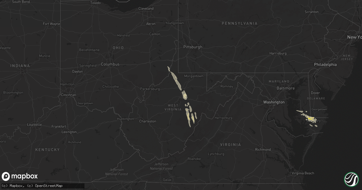
Hail Map in West Virginia on June 14, 2022
Get this storm
June 14 map
$229
one time, instant access
Download today. No call, no setup
Keep the $229
Bought the map and want the full workflow? Apply the entire $229 to a subscription within 7 days. None of it is wasted.
Every map, not just this one
This buys you this map. Subscription and you get every map we run, in the markets you choose from a few cities to whole states to nationwide. Plus real-time alerts the moment a storm fires.
Contact data
Name, contact info, occupancy, even credit band for addresses in the footprint. You go from where it hit to who to call.
Become the source they trust
Unlimited branding weather history reports on demand. You already have the documented answer ready for the property owner, and you are the one who showed up with it.
Property data and RoofTrace estimates
Pull up any address you have got, its value and the exact code rules for that jurisdiction, straight from One Click Code. Then RoofTrace estimates the squares, pitch, and roof value, priced the way you price.
Storm reports in West Virginia
West Virginia
| Date | Description |
|---|---|
| 06/14/202210:30 AM CDT | Multiple trees were blown down along hackers creek road. |
| 06/14/202210:03 AM CDT | Several trees down along alexander road. |
| 06/14/20229:45 AM CDT | A few trees were blown down along teter road. |
| 06/14/20229:22 AM CDT | Multiple trees were blown down around clarksburg. A few streets along which trees fell were sand hill road... Wilsonburg road... South chestnut street... And upper lamb |
| 06/14/20229:20 AM CDT | Multiple trees were blown down around bridgeport along johnson avenue... Anmoore road... And west main street. |
| 06/14/20229:18 AM CDT | Corrects previous non-tstm wnd dmg report from 2 wnw salem. A few trees were blown down along the northwestern turnpike. |
| 06/14/20227:58 AM CDT | At 1258 PM EDT, a severe thunderstorm was located near Marlinton, moving south at 45 mph. HAZARD...60 mph wind gusts and quarter size hail. SOURCE...Radar indicated. IMPACT...Hail damage to vehicles is expected. Expect wind damage to roofs, siding, and trees. Locations impacted include... Warm Springs... Millboro... Neola... Hot Springs... Lake Moomaw... Douthat State Park... and Natural Well. |
| 06/14/20227:58 AM CDT | At 1258 PM EDT, severe thunderstorms were located along a line extending from 8 miles north of Mountain Grove to Marlinton, moving south at 50 mph. HAZARD...60 mph wind gusts and penny size hail. SOURCE...Radar indicated. IMPACT...Expect damage to roofs, siding, and trees. Locations impacted include... Marlinton, Buckeye, Minnehaha Springs and Frost. |
| 06/14/20226:58 AM CDT | At 1158 AM EDT, severe thunderstorms were located along a line extending from near Burnsville to 9 miles northeast of Mountain Grove to near Marlinton, moving southeast at 50 mph. HAZARD...60 mph wind gusts. SOURCE...Radar indicated. IMPACT...Expect damage to roofs, siding, and trees. Locations impacted include... Marlinton, Edray, Buckeye, Minnehaha Springs and Frost. |
| 06/14/20226:53 AM CDT | At 1152 AM EDT, severe thunderstorms were located along a line extending from 9 miles northwest of Burnsville to 9 miles east of Marlinton to 12 miles southeast of Addison (Webster Springs), moving southeast at 45 mph. HAZARD...60 mph wind gusts. SOURCE...Radar indicated. IMPACT...Expect damage to roofs, siding, and trees. Locations impacted include... Clifton Forge... Warm Springs... Millboro... Hot Springs... Lake Moomaw... Douthat State Park... and Natural Well. |
| 06/14/20226:27 AM CDT | At 1125 AM EDT, a severe thunderstorm was located 7 miles south of Stonewood, or 10 miles south of Clarksburg, moving southeast at 40 mph. HAZARD...60 mph wind gusts and nickel size hail. SOURCE...Radar indicated. IMPACT...Expect damage to roofs, siding, and trees. Locations impacted include... Buckhannon, Audra State Park, Bridgeport, Stonewood, Nutter Fort, Anmoore, West Milford, Lost Creek, Jane Lew, Womelsdorf (Coalton), Alexander, Volga, Lorentz, Century, Alton, Ellamore, Tallmansville, Overhill, Hodgesville and French Creek.This includes the following highways... Interstate 79 between mile markers 104 and 118. Route 33 between mile markers 5 and 17. |
| 06/14/20226:01 AM CDT | At 1101 AM EDT, a severe thunderstorm was located 8 miles east of Rock Cave, or 11 miles south of Buckhannon, moving southeast at 50 mph. HAZARD...60 mph wind gusts and nickel size hail. SOURCE...Radar indicated. IMPACT...Expect damage to roofs, siding, and trees. Locations impacted include... Mill Creek, Rock Cave, Mingo, Huttonsville, Alexander, Monterville, Cheat Bridge, Helvetia, Pickens, Alton, Tallmansville, Valley Head and French Creek. |
| 06/14/20225:28 AM CDT | At 1028 AM EDT, a severe thunderstorm was located near Nutter Fort, or near Clarksburg, moving south at 35 mph. HAZARD...60 mph wind gusts and quarter size hail. SOURCE...Radar indicated. IMPACT...Hail damage to vehicles is expected. Expect wind damage to roofs, siding, and trees. Locations impacted include... Clarksburg, Buckhannon, Bridgeport, Stonewood, Nutter Fort, Anmoore, Rock Cave, West Milford, Lost Creek, Jane Lew, Lorentz, Century, Wolf Summit, Tallmansville, Overhill, Hodgesville, Meadowbrook, Horner, French Creek and Despard.This includes the following highways... Interstate 79 between mile markers 98 and 120. Route 50 in West Virginia between mile markers 68 and 82. Route 33 between mile markers 1 and 17. |
| 06/14/20225:01 AM CDT | At 959 AM EDT, a severe thunderstorm was located near Jacksonburg, or 10 miles west of Mannington, moving southeast at 40 mph. This was a second thunderstorm that formed behind the original one, which had weakened. HAZARD...60 mph wind gusts and nickel size hail. SOURCE...Radar indicated. IMPACT...Expect damage to roofs, siding, and trees. Locations impacted include... Clarksburg, Bridgeport, Shinnston, Stonewood, Nutter Fort, Salem, Lumberport, Anmoore, Enterprise, West Milford, Wolf Summit, Wallace, Sedalia, Meadowbrook and Despard.This includes the following highways... Interstate 79 between mile markers 114 and 128. Route 50 in West Virginia between mile markers 68 and 82. |
| 06/14/20224:37 AM CDT | At 937 AM EDT, a severe thunderstorm was located near Jacksonburg, or 11 miles west of Mannington, moving southeast at 40 mph. HAZARD...60 mph wind gusts and nickel size hail. SOURCE...Radar indicated. IMPACT...Expect damage to roofs, siding, and trees. Locations impacted include... Shinnston, Salem, Lumberport, Enterprise, Wallace, Center Point and Sedalia.This includes Route 50 in West Virginia between mile markers 64 and69. |
| 06/14/20224:27 AM CDT | At 926 AM EDT, a severe thunderstorm was located near Pine Grove, or 13 miles east of New Martinsville, moving southeast at 55 mph. HAZARD...60 mph wind gusts and quarter size hail. SOURCE...Radar indicated. IMPACT...Minor hail damage to vehicles is possible. Expect wind damage to trees and power lines, resulting in some power outages. Locations impacted include... Fairmont, Mannington, Pleasant Valley, Barrackville, Monongah, Pine Grove, Jacksonburg, Farmington, Worthington, Smithfield, Reader, and Folsom. |
| 06/13/20228:33 PM CDT | At 133 PM EDT, a severe thunderstorm was located 9 miles south of Cass Scenic Railroad, moving south at 40 mph. HAZARD...60 mph wind gusts and quarter size hail. SOURCE...Radar indicated. IMPACT...Hail damage to vehicles is expected. Expect wind damage to roofs, siding, and trees. Locations impacted include... Frost. |
| 06/13/20228:13 PM CDT | At 112 AM EDT, a severe thunderstorm was located near Coolville, moving southeast at 45 mph. HAZARD...60 mph wind gusts and nickel size hail. SOURCE...Radar indicated. IMPACT...Expect damage to roofs, siding, and trees. Locations impacted include... Athens, Pomeroy, Racine, Coolville, Forked Run State Park, Ravenswood, New Haven, Washington, Tuppers Plains, Lubeck, Chester, Syracuse, Hartford City, Portland, Reedsville, Little Hocking, Cottageville, Darwin, Mount Alto and Belleville.This includes Interstate 77 in West Virginia between mile markers 143and 167. |
| 06/13/20228:02 PM CDT | At 101 AM EDT, severe thunderstorms were located along a line extending from 9 miles southeast of Carrollton to 6 miles southwest of Wintersville to St. Clairsville, moving east at 70 mph. HAZARD...70 mph wind gusts and quarter size hail. SOURCE...Radar indicated. IMPACT...Minor hail damage to vehicles is possible. Trees snapped and uprooted. Power outages can be expected. Locations impacted include... Wheeling, Weirton, Steubenville, East Liverpool, Moundsville, Martins Ferry, St. Clairsville, Bellaire, Wellsville, Warwood, Wellsburg, and Bethlehem. |
All States Impacted by Hail Map on June 14, 2022
Cities Impacted by Hail Map on June 14, 2022
- Waskish, MN
- Big Falls, MN
- Minocqua, WI
- Granville, IA
- Orange City, IA
- Alton, IA
- Archer, IA
- Hospers, IA
- Ewing, NE
- Kabetogama, MN
- Littlefork, MN
- French Creek, WV
- Ames, IA
- Nevada, IA
- Kelley, IA
- Tallmansville, WV
- Thief River Falls, MN
- Orr, MN
- Lumber City, GA
- Camilla, GA
- Sale City, GA
- Frost, MN
- Buffalo Center, IA
- Bricelyn, MN
- Elmore, MN
- Wells, MN
- Wausau, WI
- Spring Grove, MN
- Dow City, IA
- Caledonia, MN
- Nashua, IA
- Charles City, IA
- Woodward, IA
- Boone, IA
- Adel, IA
- Minburn, IA
- Madrid, IA
- Redfield, IA
- Story City, IA
- Rippey, IA
- Gilbert, IA
- Panora, IA
- Perry, IA
- Ogden, IA
- Dallas Center, IA
- Yale, IA
- Luther, IA
- Linden, IA
- Dawson, IA
- Bouton, IA
- Millville, MN
- Grygla, MN
- Reinbeck, IA
- Cedar Falls, IA
- Dike, IA
- North Loup, NE
- Vienna, MD
- Mardela Springs, MD
- Coon Rapids, IA
- Durand, WI
- Menomonie, WI
- Cusseta, AL
- Valley, AL
- Lanett, AL
- Wolbach, NE
- Scotia, NE
- Greeley, NE
- Plummer, MN
- Oklee, MN
- Erskine, MN
- Mcintosh, MN
- Yuma, CO
- Venango, NE
- Ogallala, NE
- Grant, NE
- East Grand Forks, MN
- Warren, MN
- Parkersburg, IA
- Webster City, IA
- Marshall, NC
- Andrews, SC
- Nesmith, SC
- Hogansville, GA
- Decorah, IA
- Osage, IA
- Rudd, IA
- Plymouth, IA
- Mason City, IA
- Orchard, IA
- Nora Springs, IA
- Lac Du Flambeau, WI
- Thompson, ND
- Fisher, MN
- Thompson, IA
- Lake Mills, IA
- Scarville, IA
- Elcho, WI
- Pittsville, WI
- Black River Falls, WI
- Marshfield, WI
- Arpin, WI
- Warrens, WI
- Casey, IA
- Adair, IA
- Arcadia, NE
- Loup City, NE
- Lincoln, NE
- Walton, NE
- Greenville, GA
- Lagrange, GA
- Wellsburg, IA
- Holland, IA
- Grundy Center, IA
- Scribner, NE
- West Point, NE
- Rockwell City, IA
- Kelliher, MN
- Iowa Falls, IA
- Kesley, IA
- Allison, IA
- Williams, IA
- Hampton, IA
- Dumont, IA
- Dows, IA
- Popejoy, IA
- Aplington, IA
- Alden, IA
- Ackley, IA
- Bradford, IA
- Geneva, IA
- International Falls, MN
- Crookston, MN
- Beltrami, MN
- Ute, IA
- Charter Oak, IA
- Junction City, WI
- Auburndale, WI
- Milladore, WI
- Vesper, WI
- Mosinee, WI
- Merrill, WI
- North, SC
- Newport News, VA
- Tryon, NE
- Colfax, WI
- Elk Mound, WI
- Bovey, MN
- Deerbrook, WI
- Gleason, WI
- Blairsburg, IA
- Cambridge, MD
- Trail, MN
- Gully, MN
- Gonvick, MN
- Goodridge, MN
- Clearbrook, MN
- Neligh, NE
- Clearwater, NE
- Plainview, NE
- Mission Hill, SD
- Utica, SD
- Brunswick, NE
- Center, NE
- Creighton, NE
- Bloomfield, NE
- Crofton, NE
- Yankton, SD
- Royal, NE
- Irene, SD
- Ridgeway, IA
- Lake City, MN
- Wabasha, MN
- Wray, CO
- Holyoke, CO
- Oakwood, GA
- Gainesville, GA
- Waucoma, IA
- Fort Atkinson, IA
- Protivin, IA
- Calmar, IA
- Newfolden, MN
- Dupree, SD
- Champion, NE
- Dahlonega, GA
- Crawfordville, GA
- Denton, NE
- De Witt, NE
- Mabie, WV
- Pickens, WV
- Huttonsville, WV
- Mill Creek, WV
- Pacific Junction, IA
- Cleveland, GA
- Monterville, WV
- Slatyfork, WV
- Valley Head, WV
- Webster Springs, WV
- Marlinton, WV
- Brooklet, GA
- Red Lake Falls, MN
- Monona, IA
- Sac City, IA
- Lake View, IA
- Wall Lake, IA
- Odebolt, IA
- Kiron, IA
- Lytton, IA
- Marshalltown, IA
- Harlan, IA
- Kirkman, IA
- Manilla, IA
- Earling, IA
- Irwin, IA
- Defiance, IA
- New Providence, IA
- Moorefield, NE
- Shell Rock, IA
- New Hampton, IA
- Ionia, IA
- Hallam, NE
- Warrenton, GA
- Hooper, NE
- Uehling, NE
- Oakland, NE
- Talbotton, GA
- Woodland, GA
- Leary, GA
- Morgan, GA
- Edison, GA
- Lyle, MN
- Saint Ansgar, IA
- Northwood, IA
- Kensett, IA
- Grafton, IA
- Austin, MN
- Norman Park, GA
- Sylvania, GA
- Elko, GA
- Eastman, GA
- Cochran, GA
- Kathleen, GA
- Dry Branch, GA
- Hawkinsville, GA
- Perry, GA
- Jeffersonville, GA
- Blackduck, MN
- Blue Hill, NE
- Carleton, NE
- Red Cloud, NE
- Guide Rock, NE
- Deweese, NE
- Edgar, NE
- Davenport, NE
- Bladen, NE
- Oak, NE
- Nelson, NE
- Lawrence, NE
- Bruning, NE
- Tallahassee, FL
- Lyons, GA
- Letohatchee, AL
- Fort Deposit, AL
- Hayneville, AL
- Kermit, TX
- Albany, GA
- Sylvester, GA
- Doerun, GA
- Pleasant Dale, NE
- Milford, NE
- Malvern, IA
- Glenwood, IA
- Snow Hill, MD
- Alapaha, GA
- Fountain, FL
- Flowery Branch, GA
- Waynesboro, GA
- Cartersville, GA
- Williston, SC
- Millen, GA
- Smithfield, WV
- Windsor, SC
- Blackville, SC
- Oakland, IA
- Henderson, IA
- Carson, IA
- Macedonia, IA
- Silver City, IA
- Treynor, IA
- Baxley, GA
- Omega, GA
- Columbia, AL
- Headland, AL
- Ashford, AL
- Butler, GA
- Chula, GA
- Tifton, GA
- Council Bluffs, IA
- Junction City, GA
- Wink, TX
- Fremont, NE
- Bruno, NE
- Hampton, NE
- Bradshaw, NE
- Polk, NE
- Aurora, NE
- Bellwood, NE
- North Bend, NE
- Abie, NE
- Herman, NE
- David City, NE
- Benedict, NE
- Osceola, NE
- Rising City, NE
- Arlington, NE
- Ames, NE
- Winslow, NE
- Stromsburg, NE
- Morse Bluff, NE
- Linwood, NE
- Nickerson, NE
- Shelby, NE
- Liebenthal, KS
- Ness City, KS
- McCracken, KS
- Bazine, KS
- La Crosse, KS
- Alexander, KS
- Bison, KS
- Grand Island, NE
- Lexington, NE
- Overton, NE
- Eldora, IA
- Hubbard, IA
- Bertrand, NE
- Plattsmouth, NE
- Louisville, NE
- Weeping Water, NE
- Griswold, IA
- Emerson, IA
- Garland, NE
- Seward, NE
- Beatrice, NE
- Wood River, NE
- Valparaiso, NE
- Raymond, NE
- Malcolm, NE
- Weston, NE
- Prague, NE
- Mason City, NE
- Pleasanton, NE
- Doniphan, NE
- Trumbull, NE
- Heartwell, NE
- Kenesaw, NE
- Henderson, NE
- Gretna, NE
- Eustis, NE
- Bee, NE
- Fort Calhoun, NE
- Missouri Valley, IA
- Omaha, NE
- Bennet, NE
- Neeses, SC
- Banks, AL
- McRae Helena, GA
- Alamo, GA
- Hardaway, AL
- Ambrose, GA
- Douglas, GA
- Maywood, NE
- Curtis, NE
- Brayton, IA
- Anita, IA
- Atlantic, IA
- Elwood, NE
- Arapahoe, NE
- Smithfield, NE
- Moorland, IA
- Somers, IA
- Phillips, NE
- Saint Hilaire, MN
- Sumner, NE
- Aiken, SC
- Beaver Crossing, NE
- Dorchester, NE
- Friend, NE
- Quantico, MD
- Delmar, MD
- Linkwood, MD
- Hebron, MD
- Fruitland, MD
- East New Market, MD
- Rhodesdale, MD
- Salisbury, MD
- Delmar, DE
- Parsonsburg, MD
- Dillard, GA
- Statesboro, GA
- Troy, AL
- Vidalia, GA
- Woodbury, GA
- Warm Springs, GA
- Manchester, GA
- Moultrie, GA
- Sumner, GA
- Pine Grove, WV
- Kearney, NE
- Minden, NE
- Axtell, NE
- Sutton, NE
- York, NE
- Bethesda, OH
- Barnesville, OH
- Quaker City, OH
- Ravenna, NE
- Kennard, NE
- Hastings, NE
- Lebanon, NE
- Blair, NE
- McClelland, IA
- Litchfield, NE
- Funk, NE
- Oxford, NE
- Brainard, NE
- Holdrege, NE
- Bellevue, NE
- Mead, NE
- Edison, NE
- Elmwood, NE
- Washington, NE
- Ceresco, NE
- Crescent, IA
- Danbury, NE
- Grand Junction, IA
- Waverly, NE
- Bennington, NE
- Hazard, NE
- Holbrook, NE
- Alvo, NE
- Ashton, NE
- Papillion, NE
- Inland, NE
- Marquette, NE
- Fairmont, NE
- Ulysses, NE
- Mineola, IA
- Atlanta, NE
- Jefferson, IA
- Dwight, NE
- Manley, NE
- South Bend, NE
- Waco, NE
- Eagle, NE
- Saronville, NE
- Craig, NE
- Bayard, IA
- Waterloo, NE
- Loomis, NE
- Holstein, NE
- Harvard, NE
- Riverdale, NE
- Clay Center, NE
- Hamlin, IA
- Malmo, NE
- Bagley, IA
- Murray, NE
- Elliott, IA
- Cedar Bluffs, NE
- Stockville, NE
- Juniata, NE
- Cambridge, NE
- Colon, NE
- Guthrie Center, IA
- McCool Junction, NE
- Carter Lake, IA
- Offutt Afb, NE
- Greenwood, NE
- Davey, NE
- Shelton, NE
- Glenvil, NE
- Chapman, NE
- Elba, NE
- Giltner, NE
- Memphis, NE
- Tekamah, NE
- Avoca, NE
- Roseland, NE
- McCook, NE
- Cedar Creek, NE
- La Vista, NE
- Valley, NE
- Hordville, NE
- Staplehurst, NE
- Elkhorn, NE
- Springfield, NE
- Gibbon, NE
- Ashland, NE
- Hancock, IA
- Murdock, NE
- Wahoo, NE
- Red Oak, IA
- Elm Creek, NE
- Bartley, NE
- Walnut, IA
- Lewis, IA
- Exira, IA
- Rockville, NE
- Yutan, NE
- Alda, NE
- Ithaca, NE
- Grafton, NE
- Jamaica, IA
- Utica, NE
- Marne, IA
- Boys Town, NE
- Audubon, IA
- Gresham, NE
- Amherst, NE
- Odessa, NE
- Hamilton, GA
- Opelika, AL
- Leesburg, GA
- Ariton, AL
- Savannah, GA
- Miller, NE
- Georgetown, SC
- Neola, IA
- Underwood, IA
- Trappe, MD
- Fort Stockton, TX
- Shorterville, AL
- Abbeville, AL
- Sardis, GA
- Ozark, AL
- New Brockton, AL
- Jack, AL
- Enterprise, AL
- Minter, AL
- Hartford, AL
- Enigma, GA
- Knoxville, GA
- Roberta, GA
- Wrightsville, GA
- Cass, WV
- Dunmore, WV
- Colquitt, GA
- Newton, GA
- Box Springs, GA
- Ashburn, GA
- Georgiana, AL
- Midville, GA
- Lee, FL
- Live Oak, FL
- Dothan, AL
- Ellerslie, GA
- Cataula, GA
- Midland, GA
- Columbus, GA
- Upatoi, GA
- Ty Ty, GA
- McKenzie, AL
- Wray, GA
- Shiloh, GA
- Damascus, GA
- Arlington, GA
- Blakely, GA
- Lost Creek, WV
- Jane Lew, WV
- Buckhannon, WV
- Bartlett, NE
- Roland, IA
- McCallsburg, IA
- Radcliffe, IA
- New Hartford, IA
- Lu Verne, IA
- Bode, IA
- Hurlock, MD
- Martell, NE
- Firth, NE
- Hickman, NE
- Palmyra, NE
- Pyote, TX
- Montezuma, GA
- Coolidge, GA
- Musella, GA
- Richland, GA
- Hazlehurst, GA
- Pike Road, AL
- Mathews, AL
- Montgomery, AL
- Ramer, AL
- Greenville, AL
- Naples, FL
- Brewton, AL
- Flomaton, AL
- Clopton, AL
- Brundidge, AL
- Evergreen, AL
- Monticello, FL
- Chancellor, AL
- Proctor, WV
- Littleton, WV
- Salem, WV
- Lumberport, WV
- Clarksburg, WV
- New Martinsville, WV
- Center Point, WV
- Jacksonburg, WV
- Folsom, WV
- Burton, WV
- Wallace, WV
- Reader, WV
- Goldsmith, TX
- Notrees, TX
- Andrews, TX
- Rhine, GA
- Milan, GA
- Pine Mountain, GA
- Mershon, GA
- Alma, GA
- Jansen, NE
- Diller, NE
- Jesup, IA
- Elgin, NE
- West Point, GA
- Poquoson, VA
- Yorktown, VA
- Brunswick, GA
- Otis, KS
- Wesley, IA
- Corwith, IA
- Palatka, FL
- Green Cove Springs, FL
- Preston, GA
- Stratford, IA
- Princess Anne, MD
- New Ellenton, SC
- Minden, IA
- Samson, AL
- Ocilla, GA
- Logan, IA
- Hurtsboro, AL
- Surrency, GA
- Avoca, IA
- Barstow, TX
- Waverly Hall, GA
- Greensboro, AL
- Sycamore, GA
- Powhatan Point, OH
- Jacobsburg, OH
- Clarington, OH
- Reynolds, GA
- Willacoochee, GA
- Billingsley, AL
- Pecos, TX
- Byromville, GA
- Jones, AL
- Nicholls, GA
- Pansey, AL
- Mount Clare, WV
- Horner, WV
- Volga, WV
- Filley, NE
- Fairbury, NE
- Durbin, WV
- Green Bank, WV
- Arbovale, WV
- Warwick, GA
- Hawthorne, FL
- Citra, FL
- Metter, GA
- Cobbtown, GA
- Perkins, GA
- Scotland, SD
- Greenbush, MN
- Blue Earth, MN
- Brownell, KS
- Superior, NE
- Goehner, NE
- Viborg, SD
- Hurley, SD
- Ord, NE
- Hastings, IA
- Nehawka, NE
- Ayr, NE
- Campbell, NE
- Crystal Falls, MI
- Amasa, MI
- Iron River, MI
- Long Lake, WI
- Rhinelander, WI
- Argonne, WI
- Concord, NC
- Allendale, SC
- Ulmer, SC
- Olar, SC
- Barnwell, SC
- Fairfax, SC


