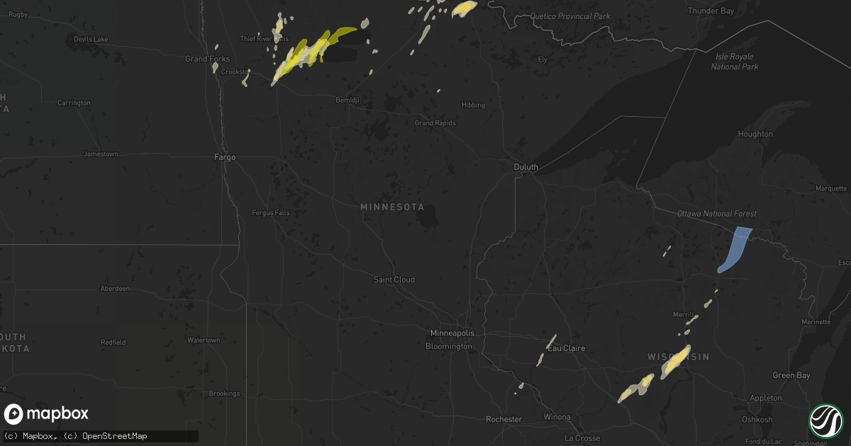
Hail Map in Minnesota on June 14, 2022
Get this storm
June 14 map
$229
one time, instant access
Download today. No call, no setup
Keep the $229
Bought the map and want the full workflow? Apply the entire $229 to a subscription within 7 days. None of it is wasted.
Every map, not just this one
This buys you this map. Subscription and you get every map we run, in the markets you choose from a few cities to whole states to nationwide. Plus real-time alerts the moment a storm fires.
Contact data
Name, contact info, occupancy, even credit band for addresses in the footprint. You go from where it hit to who to call.
Become the source they trust
Unlimited branding weather history reports on demand. You already have the documented answer ready for the property owner, and you are the one who showed up with it.
Property data and RoofTrace estimates
Pull up any address you have got, its value and the exact code rules for that jurisdiction, straight from One Click Code. Then RoofTrace estimates the squares, pitch, and roof value, priced the way you price.
Storm reports in Minnesota
Minnesota
| Date | Description |
|---|---|
| 06/14/20225:17 PM CDT | Several trees blown across highway 72 near mile marker 42 and shoreline drive north of waskish. Trees large enough to block the highway. Mndot called out to clear trees |
| 06/14/20227:48 AM CDT | Public reports 63 mph wind gust on their personal weather station. Time estimated via radar. |
| 06/14/20223:19 AM CDT | At 818 AM CDT, a severe thunderstorm was located 8 miles southwest of Gatzke, or 19 miles northeast of Thief River Falls, moving north at 65 mph. HAZARD...60 mph wind gusts and quarter size hail. SOURCE...Radar indicated. IMPACT...Hail damage to vehicles is expected. Expect wind damage to roofs, siding, and trees. This severe thunderstorm will be near... Gatzke around 825 AM CDT. Casperson and Skime around 835 AM CDT.Other locations in the path of this severe thunderstorm includeTorfin, Wannaska, Hayes Lake State Park, Pencer and Malung. |
| 06/14/20222:43 AM CDT | At 742 PM CDT, a severe thunderstorm was located near Kabetogama, or 16 miles southeast of International Falls, moving northeast at 30 mph. HAZARD...60 mph wind gusts and quarter size hail. SOURCE...Radar indicated. IMPACT...Hail damage to vehicles is expected. Expect wind damage to roofs, siding, and trees. This severe thunderstorm will be near... Kabetogama around 755 PM CDT.Other locations in the path of this severe thunderstorm includeKabetogama Lake, Rainy Lake East, Rainy Lake West and VoyageursNational Park. |
| 06/14/202212:05 AM CDT | At 505 AM CDT, a severe thunderstorm was located near Worthington, moving northeast at 50 mph. HAZARD...60 mph wind gusts and quarter size hail. SOURCE...Radar indicated. IMPACT...Hail damage to vehicles is expected. Expect wind damage to roofs, siding, and trees. This severe thunderstorm will be near... Worthington around 515 AM CDT. Brewster around 525 AM CDT.Other locations in the path of this severe thunderstorm include HeronLake and Windom. |
| 06/13/202211:33 PM CDT | At 433 PM CDT, a severe thunderstorm was located near Badger, or 13 miles southwest of Roseau, moving northeast at 40 mph. HAZARD...60 mph wind gusts and quarter size hail. SOURCE...Radar indicated. IMPACT...Hail damage to vehicles is expected. Expect wind damage to roofs, siding, and trees. This severe thunderstorm will be near... Badger around 435 PM CDT. Fox around 445 PM CDT.Other locations in the path of this severe thunderstorm include Ross,Roseau and Pinecreek. |
| 06/13/202211:27 PM CDT | At 426 PM CDT, a severe thunderstorm was located over northern Red Lake Nation, or 45 miles east of Thief River Falls, moving northeast at 50 mph. HAZARD...Golf ball size hail and 70 mph wind gusts. SOURCE...Radar indicated. IMPACT...People and animals outdoors will be injured. Expect hail damage to roofs, siding, windows, and vehicles. Expect considerable tree damage. Wind damage is also likely to mobile homes, roofs, and outbuildings. This severe thunderstorm will be near... Northwestern Upper Red Lake around 435 PM CDT.Other locations in the path of this severe thunderstorm include Carp. |
| 06/13/202210:38 PM CDT | At 338 PM CDT, a severe thunderstorm was located near Oklee, or 29 miles southeast of Thief River Falls, moving northeast at 35 mph. HAZARD...Golf ball size hail and 70 mph wind gusts. SOURCE...Radar indicated. IMPACT...People and animals outdoors will be injured. Expect hail damage to roofs, siding, windows, and vehicles. Expect considerable tree damage. Wind damage is also likely to mobile homes, roofs, and outbuildings. This severe thunderstorm will be near... Oklee around 340 PM CDT. Trail and Gully around 345 PM CDT. Roland around 350 PM CDT.Other locations in the path of this severe thunderstorm includewestern Red Lake Nation, Thorhult and Fourtown. |
| 06/13/202210:00 PM CDT | At 259 PM CDT, a severe thunderstorm was located near Winger, or 36 miles south of Thief River Falls, moving northeast at 30 mph. HAZARD...60 mph wind gusts and half dollar size hail. SOURCE...Radar indicated. IMPACT...Hail damage to vehicles is expected. Expect wind damage to roofs, siding, and trees. This severe thunderstorm will be near... Mentor around 310 PM CDT. Erskine and McIntosh around 315 PM CDT.Other locations in the path of this severe thunderstorm includeBrooks, Oklee, Trail and Roland. |
All States Impacted by Hail Map on June 14, 2022
Cities Impacted by Hail Map on June 14, 2022
- Waskish, MN
- Big Falls, MN
- Minocqua, WI
- Granville, IA
- Orange City, IA
- Alton, IA
- Archer, IA
- Hospers, IA
- Ewing, NE
- Kabetogama, MN
- Littlefork, MN
- French Creek, WV
- Ames, IA
- Nevada, IA
- Kelley, IA
- Tallmansville, WV
- Thief River Falls, MN
- Orr, MN
- Lumber City, GA
- Camilla, GA
- Sale City, GA
- Frost, MN
- Buffalo Center, IA
- Bricelyn, MN
- Elmore, MN
- Wells, MN
- Wausau, WI
- Spring Grove, MN
- Dow City, IA
- Caledonia, MN
- Nashua, IA
- Charles City, IA
- Woodward, IA
- Boone, IA
- Adel, IA
- Minburn, IA
- Madrid, IA
- Redfield, IA
- Story City, IA
- Rippey, IA
- Gilbert, IA
- Panora, IA
- Perry, IA
- Ogden, IA
- Dallas Center, IA
- Yale, IA
- Luther, IA
- Linden, IA
- Dawson, IA
- Bouton, IA
- Millville, MN
- Grygla, MN
- Reinbeck, IA
- Cedar Falls, IA
- Dike, IA
- North Loup, NE
- Vienna, MD
- Mardela Springs, MD
- Coon Rapids, IA
- Durand, WI
- Menomonie, WI
- Cusseta, AL
- Valley, AL
- Lanett, AL
- Wolbach, NE
- Scotia, NE
- Greeley, NE
- Plummer, MN
- Oklee, MN
- Erskine, MN
- Mcintosh, MN
- Yuma, CO
- Venango, NE
- Ogallala, NE
- Grant, NE
- East Grand Forks, MN
- Warren, MN
- Parkersburg, IA
- Webster City, IA
- Marshall, NC
- Andrews, SC
- Nesmith, SC
- Hogansville, GA
- Decorah, IA
- Osage, IA
- Rudd, IA
- Plymouth, IA
- Mason City, IA
- Orchard, IA
- Nora Springs, IA
- Lac Du Flambeau, WI
- Thompson, ND
- Fisher, MN
- Thompson, IA
- Lake Mills, IA
- Scarville, IA
- Elcho, WI
- Pittsville, WI
- Black River Falls, WI
- Marshfield, WI
- Arpin, WI
- Warrens, WI
- Casey, IA
- Adair, IA
- Arcadia, NE
- Loup City, NE
- Lincoln, NE
- Walton, NE
- Greenville, GA
- Lagrange, GA
- Wellsburg, IA
- Holland, IA
- Grundy Center, IA
- Scribner, NE
- West Point, NE
- Rockwell City, IA
- Kelliher, MN
- Iowa Falls, IA
- Kesley, IA
- Allison, IA
- Williams, IA
- Hampton, IA
- Dumont, IA
- Dows, IA
- Popejoy, IA
- Aplington, IA
- Alden, IA
- Ackley, IA
- Bradford, IA
- Geneva, IA
- International Falls, MN
- Crookston, MN
- Beltrami, MN
- Ute, IA
- Charter Oak, IA
- Junction City, WI
- Auburndale, WI
- Milladore, WI
- Vesper, WI
- Mosinee, WI
- Merrill, WI
- North, SC
- Newport News, VA
- Tryon, NE
- Colfax, WI
- Elk Mound, WI
- Bovey, MN
- Deerbrook, WI
- Gleason, WI
- Blairsburg, IA
- Cambridge, MD
- Trail, MN
- Gully, MN
- Gonvick, MN
- Goodridge, MN
- Clearbrook, MN
- Neligh, NE
- Clearwater, NE
- Plainview, NE
- Mission Hill, SD
- Utica, SD
- Brunswick, NE
- Center, NE
- Creighton, NE
- Bloomfield, NE
- Crofton, NE
- Yankton, SD
- Royal, NE
- Irene, SD
- Ridgeway, IA
- Lake City, MN
- Wabasha, MN
- Wray, CO
- Holyoke, CO
- Oakwood, GA
- Gainesville, GA
- Waucoma, IA
- Fort Atkinson, IA
- Protivin, IA
- Calmar, IA
- Newfolden, MN
- Dupree, SD
- Champion, NE
- Dahlonega, GA
- Crawfordville, GA
- Denton, NE
- De Witt, NE
- Mabie, WV
- Pickens, WV
- Huttonsville, WV
- Mill Creek, WV
- Pacific Junction, IA
- Cleveland, GA
- Monterville, WV
- Slatyfork, WV
- Valley Head, WV
- Webster Springs, WV
- Marlinton, WV
- Brooklet, GA
- Red Lake Falls, MN
- Monona, IA
- Sac City, IA
- Lake View, IA
- Wall Lake, IA
- Odebolt, IA
- Kiron, IA
- Lytton, IA
- Marshalltown, IA
- Harlan, IA
- Kirkman, IA
- Manilla, IA
- Earling, IA
- Irwin, IA
- Defiance, IA
- New Providence, IA
- Moorefield, NE
- Shell Rock, IA
- New Hampton, IA
- Ionia, IA
- Hallam, NE
- Warrenton, GA
- Hooper, NE
- Uehling, NE
- Oakland, NE
- Talbotton, GA
- Woodland, GA
- Leary, GA
- Morgan, GA
- Edison, GA
- Lyle, MN
- Saint Ansgar, IA
- Northwood, IA
- Kensett, IA
- Grafton, IA
- Austin, MN
- Norman Park, GA
- Sylvania, GA
- Elko, GA
- Eastman, GA
- Cochran, GA
- Kathleen, GA
- Dry Branch, GA
- Hawkinsville, GA
- Perry, GA
- Jeffersonville, GA
- Blackduck, MN
- Blue Hill, NE
- Carleton, NE
- Red Cloud, NE
- Guide Rock, NE
- Deweese, NE
- Edgar, NE
- Davenport, NE
- Bladen, NE
- Oak, NE
- Nelson, NE
- Lawrence, NE
- Bruning, NE
- Tallahassee, FL
- Lyons, GA
- Letohatchee, AL
- Fort Deposit, AL
- Hayneville, AL
- Kermit, TX
- Albany, GA
- Sylvester, GA
- Doerun, GA
- Pleasant Dale, NE
- Milford, NE
- Malvern, IA
- Glenwood, IA
- Snow Hill, MD
- Alapaha, GA
- Fountain, FL
- Flowery Branch, GA
- Waynesboro, GA
- Cartersville, GA
- Williston, SC
- Millen, GA
- Smithfield, WV
- Windsor, SC
- Blackville, SC
- Oakland, IA
- Henderson, IA
- Carson, IA
- Macedonia, IA
- Silver City, IA
- Treynor, IA
- Baxley, GA
- Omega, GA
- Columbia, AL
- Headland, AL
- Ashford, AL
- Butler, GA
- Chula, GA
- Tifton, GA
- Council Bluffs, IA
- Junction City, GA
- Wink, TX
- Fremont, NE
- Bruno, NE
- Hampton, NE
- Bradshaw, NE
- Polk, NE
- Aurora, NE
- Bellwood, NE
- North Bend, NE
- Abie, NE
- Herman, NE
- David City, NE
- Benedict, NE
- Osceola, NE
- Rising City, NE
- Arlington, NE
- Ames, NE
- Winslow, NE
- Stromsburg, NE
- Morse Bluff, NE
- Linwood, NE
- Nickerson, NE
- Shelby, NE
- Liebenthal, KS
- Ness City, KS
- McCracken, KS
- Bazine, KS
- La Crosse, KS
- Alexander, KS
- Bison, KS
- Grand Island, NE
- Lexington, NE
- Overton, NE
- Eldora, IA
- Hubbard, IA
- Bertrand, NE
- Plattsmouth, NE
- Louisville, NE
- Weeping Water, NE
- Griswold, IA
- Emerson, IA
- Garland, NE
- Seward, NE
- Beatrice, NE
- Wood River, NE
- Valparaiso, NE
- Raymond, NE
- Malcolm, NE
- Weston, NE
- Prague, NE
- Mason City, NE
- Pleasanton, NE
- Doniphan, NE
- Trumbull, NE
- Heartwell, NE
- Kenesaw, NE
- Henderson, NE
- Gretna, NE
- Eustis, NE
- Bee, NE
- Fort Calhoun, NE
- Missouri Valley, IA
- Omaha, NE
- Bennet, NE
- Neeses, SC
- Banks, AL
- McRae Helena, GA
- Alamo, GA
- Hardaway, AL
- Ambrose, GA
- Douglas, GA
- Maywood, NE
- Curtis, NE
- Brayton, IA
- Anita, IA
- Atlantic, IA
- Elwood, NE
- Arapahoe, NE
- Smithfield, NE
- Moorland, IA
- Somers, IA
- Phillips, NE
- Saint Hilaire, MN
- Sumner, NE
- Aiken, SC
- Beaver Crossing, NE
- Dorchester, NE
- Friend, NE
- Quantico, MD
- Delmar, MD
- Linkwood, MD
- Hebron, MD
- Fruitland, MD
- East New Market, MD
- Rhodesdale, MD
- Salisbury, MD
- Delmar, DE
- Parsonsburg, MD
- Dillard, GA
- Statesboro, GA
- Troy, AL
- Vidalia, GA
- Woodbury, GA
- Warm Springs, GA
- Manchester, GA
- Moultrie, GA
- Sumner, GA
- Pine Grove, WV
- Kearney, NE
- Minden, NE
- Axtell, NE
- Sutton, NE
- York, NE
- Bethesda, OH
- Barnesville, OH
- Quaker City, OH
- Ravenna, NE
- Kennard, NE
- Hastings, NE
- Lebanon, NE
- Blair, NE
- McClelland, IA
- Litchfield, NE
- Funk, NE
- Oxford, NE
- Brainard, NE
- Holdrege, NE
- Bellevue, NE
- Mead, NE
- Edison, NE
- Elmwood, NE
- Washington, NE
- Ceresco, NE
- Crescent, IA
- Danbury, NE
- Grand Junction, IA
- Waverly, NE
- Bennington, NE
- Hazard, NE
- Holbrook, NE
- Alvo, NE
- Ashton, NE
- Papillion, NE
- Inland, NE
- Marquette, NE
- Fairmont, NE
- Ulysses, NE
- Mineola, IA
- Atlanta, NE
- Jefferson, IA
- Dwight, NE
- Manley, NE
- South Bend, NE
- Waco, NE
- Eagle, NE
- Saronville, NE
- Craig, NE
- Bayard, IA
- Waterloo, NE
- Loomis, NE
- Holstein, NE
- Harvard, NE
- Riverdale, NE
- Clay Center, NE
- Hamlin, IA
- Malmo, NE
- Bagley, IA
- Murray, NE
- Elliott, IA
- Cedar Bluffs, NE
- Stockville, NE
- Juniata, NE
- Cambridge, NE
- Colon, NE
- Guthrie Center, IA
- McCool Junction, NE
- Carter Lake, IA
- Offutt Afb, NE
- Greenwood, NE
- Davey, NE
- Shelton, NE
- Glenvil, NE
- Chapman, NE
- Elba, NE
- Giltner, NE
- Memphis, NE
- Tekamah, NE
- Avoca, NE
- Roseland, NE
- McCook, NE
- Cedar Creek, NE
- La Vista, NE
- Valley, NE
- Hordville, NE
- Staplehurst, NE
- Elkhorn, NE
- Springfield, NE
- Gibbon, NE
- Ashland, NE
- Hancock, IA
- Murdock, NE
- Wahoo, NE
- Red Oak, IA
- Elm Creek, NE
- Bartley, NE
- Walnut, IA
- Lewis, IA
- Exira, IA
- Rockville, NE
- Yutan, NE
- Alda, NE
- Ithaca, NE
- Grafton, NE
- Jamaica, IA
- Utica, NE
- Marne, IA
- Boys Town, NE
- Audubon, IA
- Gresham, NE
- Amherst, NE
- Odessa, NE
- Hamilton, GA
- Opelika, AL
- Leesburg, GA
- Ariton, AL
- Savannah, GA
- Miller, NE
- Georgetown, SC
- Neola, IA
- Underwood, IA
- Trappe, MD
- Fort Stockton, TX
- Shorterville, AL
- Abbeville, AL
- Sardis, GA
- Ozark, AL
- New Brockton, AL
- Jack, AL
- Enterprise, AL
- Minter, AL
- Hartford, AL
- Enigma, GA
- Knoxville, GA
- Roberta, GA
- Wrightsville, GA
- Cass, WV
- Dunmore, WV
- Colquitt, GA
- Newton, GA
- Box Springs, GA
- Ashburn, GA
- Georgiana, AL
- Midville, GA
- Lee, FL
- Live Oak, FL
- Dothan, AL
- Ellerslie, GA
- Cataula, GA
- Midland, GA
- Columbus, GA
- Upatoi, GA
- Ty Ty, GA
- McKenzie, AL
- Wray, GA
- Shiloh, GA
- Damascus, GA
- Arlington, GA
- Blakely, GA
- Lost Creek, WV
- Jane Lew, WV
- Buckhannon, WV
- Bartlett, NE
- Roland, IA
- McCallsburg, IA
- Radcliffe, IA
- New Hartford, IA
- Lu Verne, IA
- Bode, IA
- Hurlock, MD
- Martell, NE
- Firth, NE
- Hickman, NE
- Palmyra, NE
- Pyote, TX
- Montezuma, GA
- Coolidge, GA
- Musella, GA
- Richland, GA
- Hazlehurst, GA
- Pike Road, AL
- Mathews, AL
- Montgomery, AL
- Ramer, AL
- Greenville, AL
- Naples, FL
- Brewton, AL
- Flomaton, AL
- Clopton, AL
- Brundidge, AL
- Evergreen, AL
- Monticello, FL
- Chancellor, AL
- Proctor, WV
- Littleton, WV
- Salem, WV
- Lumberport, WV
- Clarksburg, WV
- New Martinsville, WV
- Center Point, WV
- Jacksonburg, WV
- Folsom, WV
- Burton, WV
- Wallace, WV
- Reader, WV
- Goldsmith, TX
- Notrees, TX
- Andrews, TX
- Rhine, GA
- Milan, GA
- Pine Mountain, GA
- Mershon, GA
- Alma, GA
- Jansen, NE
- Diller, NE
- Jesup, IA
- Elgin, NE
- West Point, GA
- Poquoson, VA
- Yorktown, VA
- Brunswick, GA
- Otis, KS
- Wesley, IA
- Corwith, IA
- Palatka, FL
- Green Cove Springs, FL
- Preston, GA
- Stratford, IA
- Princess Anne, MD
- New Ellenton, SC
- Minden, IA
- Samson, AL
- Ocilla, GA
- Logan, IA
- Hurtsboro, AL
- Surrency, GA
- Avoca, IA
- Barstow, TX
- Waverly Hall, GA
- Greensboro, AL
- Sycamore, GA
- Powhatan Point, OH
- Jacobsburg, OH
- Clarington, OH
- Reynolds, GA
- Willacoochee, GA
- Billingsley, AL
- Pecos, TX
- Byromville, GA
- Jones, AL
- Nicholls, GA
- Pansey, AL
- Mount Clare, WV
- Horner, WV
- Volga, WV
- Filley, NE
- Fairbury, NE
- Durbin, WV
- Green Bank, WV
- Arbovale, WV
- Warwick, GA
- Hawthorne, FL
- Citra, FL
- Metter, GA
- Cobbtown, GA
- Perkins, GA
- Scotland, SD
- Greenbush, MN
- Blue Earth, MN
- Brownell, KS
- Superior, NE
- Goehner, NE
- Viborg, SD
- Hurley, SD
- Ord, NE
- Hastings, IA
- Nehawka, NE
- Ayr, NE
- Campbell, NE
- Crystal Falls, MI
- Amasa, MI
- Iron River, MI
- Long Lake, WI
- Rhinelander, WI
- Argonne, WI
- Concord, NC
- Allendale, SC
- Ulmer, SC
- Olar, SC
- Barnwell, SC
- Fairfax, SC


