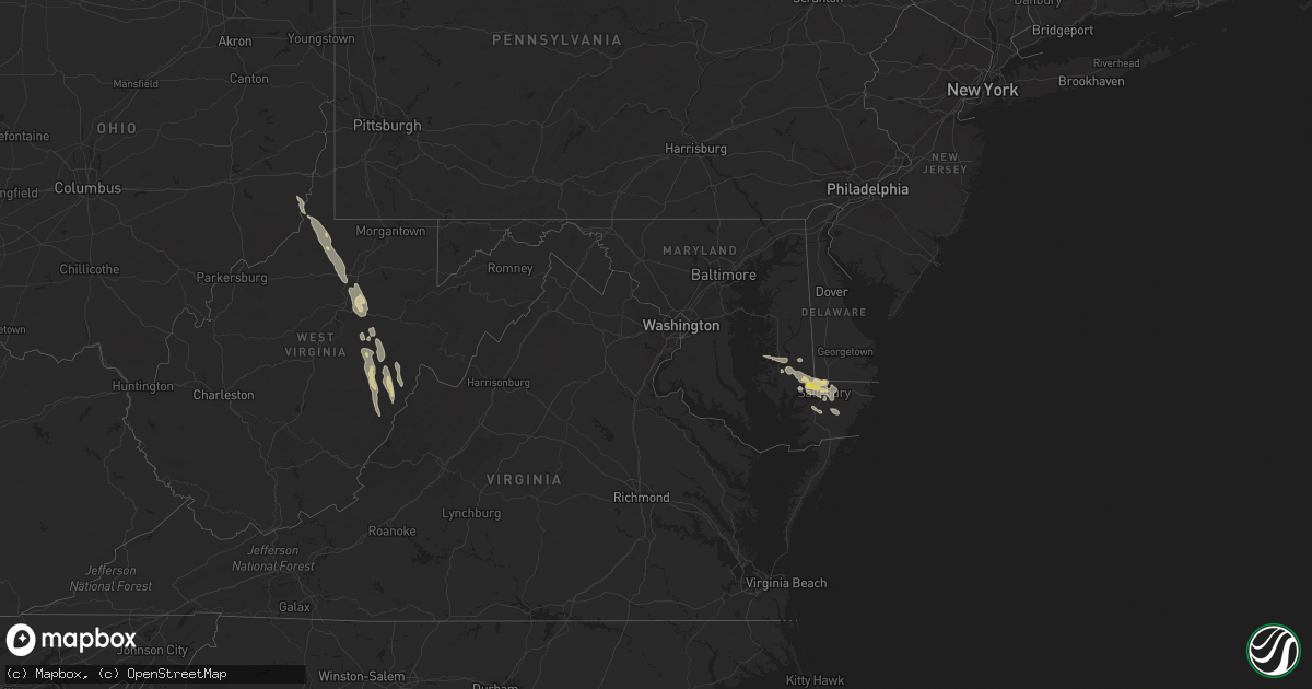
Hail Map in Maryland on June 14, 2022
Get this storm
June 14 map
$229
one time, instant access
Download today. No call, no setup
Keep the $229
Bought the map and want the full workflow? Apply the entire $229 to a subscription within 7 days. None of it is wasted.
Every map, not just this one
This buys you this map. Subscription and you get every map we run, in the markets you choose from a few cities to whole states to nationwide. Plus real-time alerts the moment a storm fires.
Contact data
Name, contact info, occupancy, even credit band for addresses in the footprint. You go from where it hit to who to call.
Become the source they trust
Unlimited branding weather history reports on demand. You already have the documented answer ready for the property owner, and you are the one who showed up with it.
Property data and RoofTrace estimates
Pull up any address you have got, its value and the exact code rules for that jurisdiction, straight from One Click Code. Then RoofTrace estimates the squares, pitch, and roof value, priced the way you price.
Storm reports in Maryland
Maryland
| Date | Description |
|---|---|
| 06/14/202210:55 AM CDT | Powerlines down. Time estimated. |
| 06/14/202210:40 AM CDT | Powerlines down in ocean pines. Time estimated. |
| 06/14/202210:15 AM CDT | Trees down in parsonsburg. |
| 06/14/202210:10 AM CDT | Trees down across salisbury. |
| 06/14/202210:06 AM CDT | Power lines down along weldon and division st. |
| 06/14/20229:42 AM CDT | A local report indicates 1.00 inch wind near HEBRON |
| 06/14/20229:20 AM CDT | Trees down causing delays on williamsburg rd. |
| 06/14/20224:52 AM CDT | At 951 AM EDT, a severe thunderstorm was located over Oxford, or 7 miles northwest of Cambridge, moving east at 25 mph. HAZARD...60 mph wind gusts and quarter size hail. SOURCE...Radar indicated. IMPACT...Minor damage to vehicles is possible. Wind damage to roofs, siding, trees, and power lines is possible. Locations impacted include... Easton, Federalsburg, Trappe, Preston, Oxford, Agner, Choptank, Tanyard, Harmony, Hambleton and Windyhill. |
| 06/14/20222:27 AM CDT | At 726 AM EDT, a severe thunderstorm was located over Severn River, moving northeast at 30 mph. HAZARD...60 mph wind gusts and penny size hail. SOURCE...Radar indicated. IMPACT...Damage to roofs, siding, trees, and power lines is possible. Locations impacted include... Centerville, Chestertown, Centreville, Romancoke, Rock Hall, Church Hill, Old Town, Grasonville, Starr, Stevensville, Langford, Chester, Overton, Starkey Corner, Carville, Hope, Queenstown, Stevensville South and Kingstown. |
| 06/13/202211:07 PM CDT | At 406 AM EDT, a severe thunderstorm was located over Big Cove Tannery, moving east at 25 mph. HAZARD...60 mph wind gusts and quarter size hail. SOURCE...Radar indicated. IMPACT...Hail damage to vehicles is expected. Expect wind damage to roofs, siding, and trees. This severe thunderstorm will be near... Big Cove Tannery around 410 AM EDT. Mercersburg and Claylick around 430 AM EDT. Greencastle, Marion and St. Thomas around 440 AM EDT.Other locations impacted by this severe thunderstorm includeWilliamson, Upton, State Line, Quincy and Whitetail Ski Area.This includes Interstate 81 from mile markers 0 to 17. |
All States Impacted by Hail Map on June 14, 2022
Cities Impacted by Hail Map on June 14, 2022
- Waskish, MN
- Big Falls, MN
- Minocqua, WI
- Granville, IA
- Orange City, IA
- Alton, IA
- Archer, IA
- Hospers, IA
- Ewing, NE
- Kabetogama, MN
- Littlefork, MN
- French Creek, WV
- Ames, IA
- Nevada, IA
- Kelley, IA
- Tallmansville, WV
- Thief River Falls, MN
- Orr, MN
- Lumber City, GA
- Camilla, GA
- Sale City, GA
- Frost, MN
- Buffalo Center, IA
- Bricelyn, MN
- Elmore, MN
- Wells, MN
- Wausau, WI
- Spring Grove, MN
- Dow City, IA
- Caledonia, MN
- Nashua, IA
- Charles City, IA
- Woodward, IA
- Boone, IA
- Adel, IA
- Minburn, IA
- Madrid, IA
- Redfield, IA
- Story City, IA
- Rippey, IA
- Gilbert, IA
- Panora, IA
- Perry, IA
- Ogden, IA
- Dallas Center, IA
- Yale, IA
- Luther, IA
- Linden, IA
- Dawson, IA
- Bouton, IA
- Millville, MN
- Grygla, MN
- Reinbeck, IA
- Cedar Falls, IA
- Dike, IA
- North Loup, NE
- Vienna, MD
- Mardela Springs, MD
- Coon Rapids, IA
- Durand, WI
- Menomonie, WI
- Cusseta, AL
- Valley, AL
- Lanett, AL
- Wolbach, NE
- Scotia, NE
- Greeley, NE
- Plummer, MN
- Oklee, MN
- Erskine, MN
- Mcintosh, MN
- Yuma, CO
- Venango, NE
- Ogallala, NE
- Grant, NE
- East Grand Forks, MN
- Warren, MN
- Parkersburg, IA
- Webster City, IA
- Marshall, NC
- Andrews, SC
- Nesmith, SC
- Hogansville, GA
- Decorah, IA
- Osage, IA
- Rudd, IA
- Plymouth, IA
- Mason City, IA
- Orchard, IA
- Nora Springs, IA
- Lac Du Flambeau, WI
- Thompson, ND
- Fisher, MN
- Thompson, IA
- Lake Mills, IA
- Scarville, IA
- Elcho, WI
- Pittsville, WI
- Black River Falls, WI
- Marshfield, WI
- Arpin, WI
- Warrens, WI
- Casey, IA
- Adair, IA
- Arcadia, NE
- Loup City, NE
- Lincoln, NE
- Walton, NE
- Greenville, GA
- Lagrange, GA
- Wellsburg, IA
- Holland, IA
- Grundy Center, IA
- Scribner, NE
- West Point, NE
- Rockwell City, IA
- Kelliher, MN
- Iowa Falls, IA
- Kesley, IA
- Allison, IA
- Williams, IA
- Hampton, IA
- Dumont, IA
- Dows, IA
- Popejoy, IA
- Aplington, IA
- Alden, IA
- Ackley, IA
- Bradford, IA
- Geneva, IA
- International Falls, MN
- Crookston, MN
- Beltrami, MN
- Ute, IA
- Charter Oak, IA
- Junction City, WI
- Auburndale, WI
- Milladore, WI
- Vesper, WI
- Mosinee, WI
- Merrill, WI
- North, SC
- Newport News, VA
- Tryon, NE
- Colfax, WI
- Elk Mound, WI
- Bovey, MN
- Deerbrook, WI
- Gleason, WI
- Blairsburg, IA
- Cambridge, MD
- Trail, MN
- Gully, MN
- Gonvick, MN
- Goodridge, MN
- Clearbrook, MN
- Neligh, NE
- Clearwater, NE
- Plainview, NE
- Mission Hill, SD
- Utica, SD
- Brunswick, NE
- Center, NE
- Creighton, NE
- Bloomfield, NE
- Crofton, NE
- Yankton, SD
- Royal, NE
- Irene, SD
- Ridgeway, IA
- Lake City, MN
- Wabasha, MN
- Wray, CO
- Holyoke, CO
- Oakwood, GA
- Gainesville, GA
- Waucoma, IA
- Fort Atkinson, IA
- Protivin, IA
- Calmar, IA
- Newfolden, MN
- Dupree, SD
- Champion, NE
- Dahlonega, GA
- Crawfordville, GA
- Denton, NE
- De Witt, NE
- Mabie, WV
- Pickens, WV
- Huttonsville, WV
- Mill Creek, WV
- Pacific Junction, IA
- Cleveland, GA
- Monterville, WV
- Slatyfork, WV
- Valley Head, WV
- Webster Springs, WV
- Marlinton, WV
- Brooklet, GA
- Red Lake Falls, MN
- Monona, IA
- Sac City, IA
- Lake View, IA
- Wall Lake, IA
- Odebolt, IA
- Kiron, IA
- Lytton, IA
- Marshalltown, IA
- Harlan, IA
- Kirkman, IA
- Manilla, IA
- Earling, IA
- Irwin, IA
- Defiance, IA
- New Providence, IA
- Moorefield, NE
- Shell Rock, IA
- New Hampton, IA
- Ionia, IA
- Hallam, NE
- Warrenton, GA
- Hooper, NE
- Uehling, NE
- Oakland, NE
- Talbotton, GA
- Woodland, GA
- Leary, GA
- Morgan, GA
- Edison, GA
- Lyle, MN
- Saint Ansgar, IA
- Northwood, IA
- Kensett, IA
- Grafton, IA
- Austin, MN
- Norman Park, GA
- Sylvania, GA
- Elko, GA
- Eastman, GA
- Cochran, GA
- Kathleen, GA
- Dry Branch, GA
- Hawkinsville, GA
- Perry, GA
- Jeffersonville, GA
- Blackduck, MN
- Blue Hill, NE
- Carleton, NE
- Red Cloud, NE
- Guide Rock, NE
- Deweese, NE
- Edgar, NE
- Davenport, NE
- Bladen, NE
- Oak, NE
- Nelson, NE
- Lawrence, NE
- Bruning, NE
- Tallahassee, FL
- Lyons, GA
- Letohatchee, AL
- Fort Deposit, AL
- Hayneville, AL
- Kermit, TX
- Albany, GA
- Sylvester, GA
- Doerun, GA
- Pleasant Dale, NE
- Milford, NE
- Malvern, IA
- Glenwood, IA
- Snow Hill, MD
- Alapaha, GA
- Fountain, FL
- Flowery Branch, GA
- Waynesboro, GA
- Cartersville, GA
- Williston, SC
- Millen, GA
- Smithfield, WV
- Windsor, SC
- Blackville, SC
- Oakland, IA
- Henderson, IA
- Carson, IA
- Macedonia, IA
- Silver City, IA
- Treynor, IA
- Baxley, GA
- Omega, GA
- Columbia, AL
- Headland, AL
- Ashford, AL
- Butler, GA
- Chula, GA
- Tifton, GA
- Council Bluffs, IA
- Junction City, GA
- Wink, TX
- Fremont, NE
- Bruno, NE
- Hampton, NE
- Bradshaw, NE
- Polk, NE
- Aurora, NE
- Bellwood, NE
- North Bend, NE
- Abie, NE
- Herman, NE
- David City, NE
- Benedict, NE
- Osceola, NE
- Rising City, NE
- Arlington, NE
- Ames, NE
- Winslow, NE
- Stromsburg, NE
- Morse Bluff, NE
- Linwood, NE
- Nickerson, NE
- Shelby, NE
- Liebenthal, KS
- Ness City, KS
- McCracken, KS
- Bazine, KS
- La Crosse, KS
- Alexander, KS
- Bison, KS
- Grand Island, NE
- Lexington, NE
- Overton, NE
- Eldora, IA
- Hubbard, IA
- Bertrand, NE
- Plattsmouth, NE
- Louisville, NE
- Weeping Water, NE
- Griswold, IA
- Emerson, IA
- Garland, NE
- Seward, NE
- Beatrice, NE
- Wood River, NE
- Valparaiso, NE
- Raymond, NE
- Malcolm, NE
- Weston, NE
- Prague, NE
- Mason City, NE
- Pleasanton, NE
- Doniphan, NE
- Trumbull, NE
- Heartwell, NE
- Kenesaw, NE
- Henderson, NE
- Gretna, NE
- Eustis, NE
- Bee, NE
- Fort Calhoun, NE
- Missouri Valley, IA
- Omaha, NE
- Bennet, NE
- Neeses, SC
- Banks, AL
- McRae Helena, GA
- Alamo, GA
- Hardaway, AL
- Ambrose, GA
- Douglas, GA
- Maywood, NE
- Curtis, NE
- Brayton, IA
- Anita, IA
- Atlantic, IA
- Elwood, NE
- Arapahoe, NE
- Smithfield, NE
- Moorland, IA
- Somers, IA
- Phillips, NE
- Saint Hilaire, MN
- Sumner, NE
- Aiken, SC
- Beaver Crossing, NE
- Dorchester, NE
- Friend, NE
- Quantico, MD
- Delmar, MD
- Linkwood, MD
- Hebron, MD
- Fruitland, MD
- East New Market, MD
- Rhodesdale, MD
- Salisbury, MD
- Delmar, DE
- Parsonsburg, MD
- Dillard, GA
- Statesboro, GA
- Troy, AL
- Vidalia, GA
- Woodbury, GA
- Warm Springs, GA
- Manchester, GA
- Moultrie, GA
- Sumner, GA
- Pine Grove, WV
- Kearney, NE
- Minden, NE
- Axtell, NE
- Sutton, NE
- York, NE
- Bethesda, OH
- Barnesville, OH
- Quaker City, OH
- Ravenna, NE
- Kennard, NE
- Hastings, NE
- Lebanon, NE
- Blair, NE
- McClelland, IA
- Litchfield, NE
- Funk, NE
- Oxford, NE
- Brainard, NE
- Holdrege, NE
- Bellevue, NE
- Mead, NE
- Edison, NE
- Elmwood, NE
- Washington, NE
- Ceresco, NE
- Crescent, IA
- Danbury, NE
- Grand Junction, IA
- Waverly, NE
- Bennington, NE
- Hazard, NE
- Holbrook, NE
- Alvo, NE
- Ashton, NE
- Papillion, NE
- Inland, NE
- Marquette, NE
- Fairmont, NE
- Ulysses, NE
- Mineola, IA
- Atlanta, NE
- Jefferson, IA
- Dwight, NE
- Manley, NE
- South Bend, NE
- Waco, NE
- Eagle, NE
- Saronville, NE
- Craig, NE
- Bayard, IA
- Waterloo, NE
- Loomis, NE
- Holstein, NE
- Harvard, NE
- Riverdale, NE
- Clay Center, NE
- Hamlin, IA
- Malmo, NE
- Bagley, IA
- Murray, NE
- Elliott, IA
- Cedar Bluffs, NE
- Stockville, NE
- Juniata, NE
- Cambridge, NE
- Colon, NE
- Guthrie Center, IA
- McCool Junction, NE
- Carter Lake, IA
- Offutt Afb, NE
- Greenwood, NE
- Davey, NE
- Shelton, NE
- Glenvil, NE
- Chapman, NE
- Elba, NE
- Giltner, NE
- Memphis, NE
- Tekamah, NE
- Avoca, NE
- Roseland, NE
- McCook, NE
- Cedar Creek, NE
- La Vista, NE
- Valley, NE
- Hordville, NE
- Staplehurst, NE
- Elkhorn, NE
- Springfield, NE
- Gibbon, NE
- Ashland, NE
- Hancock, IA
- Murdock, NE
- Wahoo, NE
- Red Oak, IA
- Elm Creek, NE
- Bartley, NE
- Walnut, IA
- Lewis, IA
- Exira, IA
- Rockville, NE
- Yutan, NE
- Alda, NE
- Ithaca, NE
- Grafton, NE
- Jamaica, IA
- Utica, NE
- Marne, IA
- Boys Town, NE
- Audubon, IA
- Gresham, NE
- Amherst, NE
- Odessa, NE
- Hamilton, GA
- Opelika, AL
- Leesburg, GA
- Ariton, AL
- Savannah, GA
- Miller, NE
- Georgetown, SC
- Neola, IA
- Underwood, IA
- Trappe, MD
- Fort Stockton, TX
- Shorterville, AL
- Abbeville, AL
- Sardis, GA
- Ozark, AL
- New Brockton, AL
- Jack, AL
- Enterprise, AL
- Minter, AL
- Hartford, AL
- Enigma, GA
- Knoxville, GA
- Roberta, GA
- Wrightsville, GA
- Cass, WV
- Dunmore, WV
- Colquitt, GA
- Newton, GA
- Box Springs, GA
- Ashburn, GA
- Georgiana, AL
- Midville, GA
- Lee, FL
- Live Oak, FL
- Dothan, AL
- Ellerslie, GA
- Cataula, GA
- Midland, GA
- Columbus, GA
- Upatoi, GA
- Ty Ty, GA
- McKenzie, AL
- Wray, GA
- Shiloh, GA
- Damascus, GA
- Arlington, GA
- Blakely, GA
- Lost Creek, WV
- Jane Lew, WV
- Buckhannon, WV
- Bartlett, NE
- Roland, IA
- McCallsburg, IA
- Radcliffe, IA
- New Hartford, IA
- Lu Verne, IA
- Bode, IA
- Hurlock, MD
- Martell, NE
- Firth, NE
- Hickman, NE
- Palmyra, NE
- Pyote, TX
- Montezuma, GA
- Coolidge, GA
- Musella, GA
- Richland, GA
- Hazlehurst, GA
- Pike Road, AL
- Mathews, AL
- Montgomery, AL
- Ramer, AL
- Greenville, AL
- Naples, FL
- Brewton, AL
- Flomaton, AL
- Clopton, AL
- Brundidge, AL
- Evergreen, AL
- Monticello, FL
- Chancellor, AL
- Proctor, WV
- Littleton, WV
- Salem, WV
- Lumberport, WV
- Clarksburg, WV
- New Martinsville, WV
- Center Point, WV
- Jacksonburg, WV
- Folsom, WV
- Burton, WV
- Wallace, WV
- Reader, WV
- Goldsmith, TX
- Notrees, TX
- Andrews, TX
- Rhine, GA
- Milan, GA
- Pine Mountain, GA
- Mershon, GA
- Alma, GA
- Jansen, NE
- Diller, NE
- Jesup, IA
- Elgin, NE
- West Point, GA
- Poquoson, VA
- Yorktown, VA
- Brunswick, GA
- Otis, KS
- Wesley, IA
- Corwith, IA
- Palatka, FL
- Green Cove Springs, FL
- Preston, GA
- Stratford, IA
- Princess Anne, MD
- New Ellenton, SC
- Minden, IA
- Samson, AL
- Ocilla, GA
- Logan, IA
- Hurtsboro, AL
- Surrency, GA
- Avoca, IA
- Barstow, TX
- Waverly Hall, GA
- Greensboro, AL
- Sycamore, GA
- Powhatan Point, OH
- Jacobsburg, OH
- Clarington, OH
- Reynolds, GA
- Willacoochee, GA
- Billingsley, AL
- Pecos, TX
- Byromville, GA
- Jones, AL
- Nicholls, GA
- Pansey, AL
- Mount Clare, WV
- Horner, WV
- Volga, WV
- Filley, NE
- Fairbury, NE
- Durbin, WV
- Green Bank, WV
- Arbovale, WV
- Warwick, GA
- Hawthorne, FL
- Citra, FL
- Metter, GA
- Cobbtown, GA
- Perkins, GA
- Scotland, SD
- Greenbush, MN
- Blue Earth, MN
- Brownell, KS
- Superior, NE
- Goehner, NE
- Viborg, SD
- Hurley, SD
- Ord, NE
- Hastings, IA
- Nehawka, NE
- Ayr, NE
- Campbell, NE
- Crystal Falls, MI
- Amasa, MI
- Iron River, MI
- Long Lake, WI
- Rhinelander, WI
- Argonne, WI
- Concord, NC
- Allendale, SC
- Ulmer, SC
- Olar, SC
- Barnwell, SC
- Fairfax, SC


