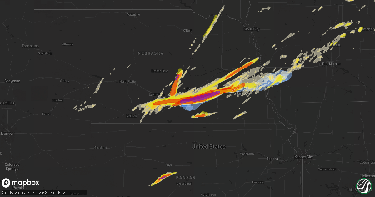
Hail Map on June 14, 2022
Get this storm
June 14 map
$229
one time, instant access
Download today. No call, no setup
Keep the $229
Bought the map and want the full workflow? Apply the entire $229 to a subscription within 7 days. None of it is wasted.
Every map, not just this one
This buys you this map. Subscription and you get every map we run, in the markets you choose from a few cities to whole states to nationwide. Plus real-time alerts the moment a storm fires.
Contact data
Name, contact info, occupancy, even credit band for addresses in the footprint. You go from where it hit to who to call.
Become the source they trust
Unlimited branding weather history reports on demand. You already have the documented answer ready for the property owner, and you are the one who showed up with it.
Property data and RoofTrace estimates
Pull up any address you have got, its value and the exact code rules for that jurisdiction, straight from One Click Code. Then RoofTrace estimates the squares, pitch, and roof value, priced the way you price.
States Impacted by Hail Map on June 14, 2022
Storm reports
New Jersey
| Date | Description |
|---|---|
| 06/14/20222:14 AM CDT | At 714 AM EDT, a severe thunderstorm was located over Hockessin, or 7 miles west of Wilmington, moving east at 45 mph. HAZARD...60 mph wind gusts and penny size hail. SOURCE...Radar indicated. IMPACT...Damage to roofs, siding, trees, and power lines is possible. Locations impacted include... Wilmington, Newark, Chester, Deptford, West Deptford, Glassboro, Pennsville, Bellmawr, Woodbury, Pitman, Carneys Point, Folcroft, Elsmere, Paulsboro, Kennett Square, New Castle, Penns Grove, Westville, Woodbury Heights and National Park.This includes the following highways... New Jersey Turnpike near exit 2. Interstate 95 in Pennsylvania between mile markers 0 and 12. Interstate 95 in Delaware between mile markers 8 and 23. Interstate 295 in New Jersey near mile marker 0, and between milemarkers 2 and 26. Interstate 476 in Pennsylvania near mile marker 0. |
Iowa
| Date | Description |
|---|---|
| 06/14/20226:39 AM CDT | At 1139 PM CDT, a severe thunderstorm was located over Louisville, or 9 miles south of Gretna, moving east at 30 mph. HAZARD...60 mph wind gusts and quarter size hail. SOURCE...Radar indicated. IMPACT...Hail damage to vehicles is expected. Expect wind damage to roofs, siding, and trees. This severe thunderstorm will be near... Springfield around 1145 PM CDT. Cedar Creek around 1150 PM CDT.Other locations in the path of this severe thunderstorm includeBellevue, Offutt AFB, Murray, Beaver Lake, Plattsmouth, PacificJunction and Glenwood.This includes the following highways... Interstate 29 between mile markers 12 and 54. Interstate 80 in Iowa between mile markers 1 and 8. Interstate 80 in Nebraska between mile markers 415 and 454. |
| 06/14/20226:21 AM CDT | At 1121 PM CDT, a severe thunderstorm was located near Gilbert, or near Ames, moving northeast at 35 mph. HAZARD...60 mph wind gusts and quarter size hail. SOURCE...Radar indicated. IMPACT...Hail damage to vehicles is expected. Expect wind damage to roofs, siding, and trees. This severe thunderstorm will be near... Roland around 1130 PM CDT. McCallsburg around 1135 PM CDT.Other locations in the path of this severe thunderstorm includeZearing, Radcliffe, Garden City, Drake Airport, Hubbard and NewProvidence.This includes Interstate 35 between mile markers 111 and 128. |
| 06/14/20225:38 AM CDT | At 1037 PM CDT, a severe thunderstorm was located 7 miles northeast of Iowa Falls, moving northeast at 35 mph. HAZARD...60 mph wind gusts and half dollar size hail. SOURCE...Radar indicated. IMPACT...Hail damage to vehicles is expected. Expect wind damage to roofs, siding, and trees. This severe thunderstorm will be near... Ackley, Geneva and Ackley Municipal Airport around 1045 PM CDT. Hansell around 1050 PM CDT.Other locations in the path of this severe thunderstorm includeAplington, Dumont, Bristow, Allison and Allison Municipal Airport. |
| 06/14/20225:29 AM CDT | At 1029 PM CDT, a severe thunderstorm was located 14 miles northeast of Atlantic, moving northeast at 35 mph. HAZARD...60 mph wind gusts and quarter size hail. SOURCE...Radar indicated. IMPACT...Hail damage to vehicles is expected. Expect wind damage to roofs, siding, and trees. This severe thunderstorm will be near... Adair around 1040 PM CDT.Other locations in the path of this severe thunderstorm includeGuthrie Center, Panora, Lake Panorama and Springbrook State Park.This includes Interstate 80 between mile markers 62 and 79. |
| 06/14/20225:10 AM CDT | At 1010 PM CDT, a severe thunderstorm was located over Oakland, or 20 miles northwest of Red Oak, moving northeast at 35 mph. HAZARD...60 mph wind gusts and quarter size hail. SOURCE...Radar indicated. IMPACT...Hail damage to vehicles is expected. Expect wind damage to roofs, siding, and trees. This severe thunderstorm will remain over mainly rural areas of southeastern Pottawattamie County. |
| 06/14/20224:58 AM CDT | At 958 PM CDT, a severe thunderstorm was located 10 miles west of Iowa Falls, moving northeast at 35 mph. HAZARD...60 mph wind gusts and half dollar size hail. SOURCE...Radar indicated. IMPACT...Hail damage to vehicles is expected. Expect wind damage to roofs, siding, and trees. This severe thunderstorm will be near... Iowa Falls around 1015 PM CDT.Other locations in the path of this severe thunderstorm includeBradford, Hampton Municipal Airport, Hampton, Geneva and Hansell.This includes Interstate 35 between mile markers 138 and 162. |
| 06/14/20224:42 AM CDT | At 942 PM CDT, a severe thunderstorm was located near Elliott, or 17 miles southwest of Atlantic, moving northeast at 45 mph. HAZARD...70 mph wind gusts and half dollar size hail. SOURCE...Radar indicated. IMPACT...Hail damage to vehicles is expected. Expect considerable tree damage. Wind damage is also likely to mobile homes, roofs, and outbuildings. This severe thunderstorm will be near... Griswold and Griswold Park around 950 PM CDT. Lewis and Cold Springs State Park around 955 PM CDT.Other locations in the path of this severe thunderstorm includeAtlantic, Cumberland, Atlantic Municipal Airport, Wiota, Anita, LakeAnita State Park and Anita Municipal Airport.This includes Interstate 80 between mile markers 59 and 71. |
| 06/14/20224:39 AM CDT | At 939 PM CDT, a severe thunderstorm was located 6 miles east of Carson, or 13 miles north of Red Oak, moving northeast at 30 mph. HAZARD...70 mph wind gusts and half dollar size hail. SOURCE...Radar indicated. IMPACT...Hail damage to vehicles is expected. Expect considerable tree damage. Wind damage is also likely to mobile homes, roofs, and outbuildings. This severe thunderstorm will be near... Elliott around 950 PM CDT. |
| 06/14/20224:07 AM CDT | At 907 PM CDT, a severe thunderstorm was located 4 miles northwest of Hastings, or 17 miles west of Red Oak, moving northeast at 30 mph. HAZARD...Golf ball size hail and 60 mph wind gusts. SOURCE...Radar indicated. IMPACT...People and animals outdoors will be injured. Expect hail damage to roofs, siding, windows, and vehicles. Expect wind damage to roofs, siding, and trees. This severe thunderstorm will be near... Henderson around 925 PM CDT.Other locations in the path of this severe thunderstorm includeCarson, Macedonia and Elliott. |
| 06/14/20223:00 AM CDT | Strong winds also reported. Relayed by kwwl tv. |
| 06/14/20222:40 AM CDT | Measured at the marshalltown airport. |
| 06/14/20222:28 AM CDT | Trees down. |
| 06/14/20222:19 AM CDT | Multiple trees down... Roof damage with strong winds. Time estimated via radar. |
| 06/14/202212:54 AM CDT | Report of large tree on vehicle. Time estimate via radar. |
| 06/14/202212:46 AM CDT | A local report indicates 70 MPH wind near ELLIOTT |
| 06/14/202212:40 AM CDT | Power lines down. Power out in town. Structural damage to one business. Debris in streets. |
| 06/14/202212:40 AM CDT | A local report indicates 70 MPH wind near 6 W ELLIOTT |
| 06/14/202212:35 AM CDT | From facebook. |
| 06/14/202212:35 AM CDT | Large trees down in the wheeler grove township. |
| 06/14/202212:30 AM CDT | 1 inch trees snapped. |
| 06/14/202212:27 AM CDT | Substantial damage to a farmstead. Grain bins destroyed. Other buildings blown off foundation. |
| 06/14/202212:25 AM CDT | 6 inch tree limb blown down... Blocking road. |
| 06/14/202212:25 AM CDT | 8 to 10 large trees snapped. Significant damage to a home and outbuilding. Time estimated based on radar. |
| 06/14/202212:20 AM CDT | A local report indicates 60 MPH wind near TREYNOR |
| 06/14/202212:20 AM CDT | Report from mping: 1-inch tree limbs broken; shingles blown off. |
| 06/14/202212:18 AM CDT | A local report indicates 90 MPH wind near SILVER CITY |
| 06/14/202212:16 AM CDT | A local report indicates 75 MPH wind near 5 ENE COUNCIL BLUFFS |
| 06/14/202212:12 AM CDT | Power lines down. Power out in glenwood. |
| 06/14/202212:10 AM CDT | A local report indicates 65 MPH wind near 4 NW SILVER CITY |
| 06/13/202211:23 PM CDT | Report via social media. I-35 rest area south bound. Time estimated by radar. |
| 06/13/202211:08 PM CDT | A local report indicates 1.00 inch wind near 5 NW APLINGTON |
| 06/13/20229:29 PM CDT | At 229 AM CDT, a severe thunderstorm was located over Vermillion, moving northeast at 50 mph. HAZARD...60 mph wind gusts. SOURCE...Radar indicated. IMPACT...Expect damage to roofs, siding, and trees. This severe thunderstorm will be near... Union Grove State Park around 245 AM CDT.Other locations in the path of this severe thunderstorm includeBeresford, Hawarden and Alcester. |
| 06/13/20229:20 PM CDT | Relayed via broadcast media. Picture of hail larger than a quarter. Time estimated from radar. |
North Carolina
| Date | Description |
|---|---|
| 06/14/20227:52 AM CDT | At 1252 AM EDT, a severe thunderstorm was located near Woolwine, moving southeast at 15 mph. HAZARD...60 mph wind gusts. SOURCE...Radar indicated. IMPACT...Expect damage to roofs, siding, and trees. Locations impacted include... Stuart... Floyd... Bassett... Woolwine... Ferrum... Endicott... and Critz. |
| 06/14/20227:13 AM CDT | Trees and power lines down on forsythe st near virginia rd. |
| 06/14/20226:29 AM CDT | At 1128 AM EDT, a severe thunderstorm was located 10 miles northeast of Clayton, or near Sky Valley, moving west at 10 mph. HAZARD...60 mph wind gusts and quarter size hail. SOURCE...Radar indicated. IMPACT...Minor hail damage to vehicles is expected. Expect wind damage to trees and power lines. Locations impacted include... Highlands, Mountain City, Dillard, Sky Valley, Scaly Mountain, Otto and Black Rock Mountain State Park. |
| 06/14/20222:46 AM CDT | At 746 AM EDT, severe thunderstorms were located along a line extending from 7 miles west of Morganton to 9 miles southwest of Spruce Pine, moving southwest at 15 mph. HAZARD...60 mph wind gusts and nickel size hail. SOURCE...Radar indicated. IMPACT...Expect damage to trees and power lines. Locations impacted include... Marion, Black Mountain, Swannanoa, Glen Alpine, Old Fort, Lake James State Park, Mount Mitchell State Park, Lake James, Montreat, and a portion of the Blue Ridge Parkway from Craggy To Little Switzerland. |
| 06/14/20221:09 AM CDT | At 608 AM EDT, severe thunderstorms were located along a line extending from 3 miles southeast of Traphill to 9 miles southeast of Deep Gap to 3 miles southwest of Beech Mountain to 4 miles north of Elizabethton, moving south at 35 mph. HAZARD...60 mph wind gusts. SOURCE...Radar indicated. IMPACT...Expect damage to trees and power lines. Locations impacted include... Hickory, Lenoir, Morganton, Spruce Pine, Taylorsville, Burnsville, Newland, St. Stephens, Longview and Sawmills. |
| 06/13/202211:49 PM CDT | At 449 AM EDT, a severe thunderstorm was located over Nebo, or 7 miles southwest of Ceres, moving southeast at 55 mph. HAZARD...60 mph wind gusts and quarter size hail. SOURCE...Radar indicated. IMPACT...Hail damage to vehicles is expected. Expect wind damage to roofs, siding, and trees. Locations impacted include... Wytheville... Galax... Marion... Tazewell... Hillsville... Saltville... and Chilhowie. |
| 06/13/20229:07 PM CDT | At 207 AM EDT, a severe thunderstorm was located over Pine Hall, or near Walnut Cove, moving southeast at 30 mph. HAZARD...60 mph wind gusts. SOURCE...Radar indicated. IMPACT...Expect damage to roofs, siding, and trees. Locations impacted include... Reidsville... Wentworth... Mayodan... Madison... Walnut Cove... King... and Pine Hall. |
| 06/13/20229:05 PM CDT | At 204 AM EDT, severe thunderstorms were located along a line extending from Walnut Cove to near Enon, moving southeast at 25 mph. HAZARD...60 mph wind gusts. SOURCE...Radar indicated. IMPACT...Expect damage to roofs, siding, and trees. Locations impacted include... Greensboro, Winston-Salem, High Point, Lexington, Thomasville, Kernersville, Clemmons, Bermuda Run, Huntsville and McLeansville. |
| 06/13/20228:52 PM CDT | At 151 PM EDT, severe thunderstorms were located along a line extending from Cody to near Java to near Pittsville, moving south at 50 mph. HAZARD...60 mph wind gusts. SOURCE...Radar indicated. IMPACT...Expect damage to roofs, siding, and trees. Locations impacted include... South Boston... Halifax... Chatham... Gretna... Prospect Hill... Turbeville... and Ingram. |
Virginia
| Date | Description |
|---|---|
| 06/14/20221:07 PM CDT | One tree was blown down on river road. Time estimated by radar. |
| 06/14/20221:05 PM CDT | Tree down. Time estimated from radar. |
| 06/14/202212:45 PM CDT | 60 year old tractor shed blown down by thunderstorm winds in gretna va. Report from wdbj7. |
| 06/14/202212:31 PM CDT | One tree was blown down on clover road near hurt. Time estimated by radar. |
| 06/14/202212:28 PM CDT | Corrects previous tstm wnd dmg report from 1 wnw altavista. Multiple trees down on lynch rd. Time estimated from radar. Report by kd country radio. |
| 06/14/202212:28 PM CDT | Trees down on lynch mill rd. Time estimated from radar. Report by kd country radio. |
| 06/14/202212:14 PM CDT | Tree down on pinecrest ave. Time estimated from radar. |
| 06/14/202212:09 PM CDT | Tree down near intersection of centerville rd and benchmark lane. Time estimated from radar. |
| 06/14/202212:05 PM CDT | Tree down on hurricane reef drive. Time estimated by radar. |
| 06/14/202211:31 AM CDT | Thunderstorm winds blew five trees down around property. |
| 06/14/202211:00 AM CDT | Tree limbs blew down onto the driveway of a residence near mustoe. |
| 06/14/20229:11 AM CDT | Tree down on oriana rd. |
| 06/14/20227:31 AM CDT | At 1230 PM EDT, severe thunderstorms were located along a line extending from 6 miles north of Snowshoe to 10 miles northwest of Cass Scenic Railroad to 11 miles east of Addison (Webster Springs), moving south at 40 mph. HAZARD...60 mph wind gusts and penny size hail. SOURCE...Radar indicated. IMPACT...Expect damage to roofs, siding, and trees. Locations impacted include... Marlinton, Cass Scenic Railroad, Greenbank, Snowshoe, Mingo, Dunmore, Slaty Fork, Minnehaha Springs, Frost, Waneta, Edray, Buckeye and Valley Head. |
| 06/14/20227:22 AM CDT | At 1222 PM EDT, a severe thunderstorm was located over Millboro, moving southeast at 45 mph. HAZARD...60 mph wind gusts. SOURCE...Radar indicated. IMPACT...Expect damage to roofs, siding, and trees. Locations impacted include... Lexington... Buena Vista... Glasgow... Goshen... Millboro... Collierstown... and Rockbridge Baths.This includes The following Location VMI. |
| 06/14/20227:03 AM CDT | At 1202 PM EDT, severe thunderstorms were located along a line extending from near Mill Creek to 12 miles west of Dailey to near Rock Cave, moving south at 45 mph. HAZARD...60 mph wind gusts and nickel size hail. SOURCE...Radar indicated. IMPACT...Expect damage to roofs, siding, and trees. Locations impacted include... Cass Scenic Railroad, Greenbank, Mill Creek, Snowshoe, Holly River State Park, Rock Cave, Mingo, Durbin, Huttonsville, Alexander, Arbovale, Cheat Bridge, Eden, Helvetia, Pickens, Waneta, Boyer, Kanawha Head, Bergoo and Dunmore. |
| 06/14/20226:59 AM CDT | At 1159 AM EDT, a severe thunderstorm was located near Burnsville, or 13 miles southwest of Monterey, moving south at 40 mph. Another thunderstorm was just west of Elkins, also moving southeast. HAZARD...60 mph wind gusts. SOURCE...Radar indicated. IMPACT...Damaging winds will cause some trees and large branches to fall. This could injure those outdoors, as well as damage homes and vehicles. Roadways may become blocked by downed trees. Localized power outages are possible. Unsecured light objects may become projectiles. Locations impacted include... Williamsville, Clover Creek, Mustoe, Vanderpool, Bolar and Mill Gap. |
| 06/14/20226:54 AM CDT | At 1153 AM EDT, a severe thunderstorm was located near University Of Maryland Eastern Shore, moving southeast at 30 mph. Another severe storm was located just west of Snow Hill moving southeast at 30 mph. HAZARD...60 mph wind gusts and quarter size hail. SOURCE...Radar indicated. IMPACT...Minor damage to vehicles is possible. Expect wind damage to trees and powerlines. Locations impacted include... Fruitland, Pocomoke City, Princess Anne, University Of Maryland Eastern Shore, Snow Hill, West Pocomoke, Boxiron, Cokesbury, Goodwill, Public Landing, Eden, Longridge, Cedartown, Mount Wesley, Girdletree, Stockton and Whitesburg. |
| 06/14/20226:30 AM CDT | At 1130 AM EDT, severe thunderstorms were located along a line extending from 8 miles north of Greenbank to 6 miles northeast of Snowshoe to 7 miles south of Holly River State Park, moving southeast at 55 mph. HAZARD...60 mph wind gusts and penny size hail. SOURCE...Radar indicated. IMPACT...Expect damage to roofs, siding, and trees. Locations impacted include... Marlinton, Cass Scenic Railroad, Greenbank, Snowshoe, Mingo, Durbin, Dunmore, Monterville, Arbovale, Bartow, Slaty Fork, Minnehaha Springs, Frost, Waneta, Boyer, Edray, Buckeye, Valley Head and Bergoo. |
| 06/14/20225:06 AM CDT | At 1006 AM EDT, severe thunderstorms were located along a line extending from Lee Hall to near Langley AFB, moving east at 45 mph. HAZARD...60 mph wind gusts and nickel size hail. SOURCE...Radar indicated. IMPACT...Expect damage to trees and powerlines. Severe thunderstorms will be near... Langley AFB around 1010 AM EDT. Grand View and Buckroe Beach around 1015 AM EDT. Seaford around 1020 AM EDT. Hampton around 1025 AM EDT.Other locations impacted by these severe thunderstorms include Dare,Newport News Golf Course, Fox Hill, Langley View, Oyster Point,Oriana, Messick, Hornsbyville, Harris Grove and Plum Tree IslandRefuge. |
| 06/14/202212:49 AM CDT | At 548 AM EDT, a severe thunderstorm was located over Jefferson, moving southeast at 55 mph. This storm has a history of causing damage to trees. HAZARD...60 mph wind gusts. SOURCE...Radar indicated. IMPACT...Expect damage to roofs, siding, and trees. Locations impacted include... Boone... North Wilkesboro... Wilkesboro... Sparta... Jefferson... West Jefferson... and Blowing Rock.This includes The following Location Appalachian State University. |
| 06/13/20228:26 PM CDT | At 126 PM EDT, severe thunderstorms were located along a line extending from near Rustburg to near Altavista to near Moneta, moving south at 40 mph. HAZARD...60 mph wind gusts. SOURCE...Radar indicated. IMPACT...Expect damage to roofs, siding, and trees. Locations impacted include... Altavista... Hurt... Chatham... Gretna... Brookneal... Huddleston... and Moneta. |
| 06/13/20228:02 PM CDT | At 102 PM EDT, severe thunderstorms were located along a line extending from 7 miles northeast of Snowshoe to 10 miles north of Cass Scenic Railroad to 9 miles southwest of Mill Creek, moving south at 35 mph. HAZARD...60 mph wind gusts and quarter size hail. SOURCE...Radar indicated. IMPACT...Hail damage to vehicles is expected. Expect wind damage to roofs, siding, and trees. Locations impacted include... Cass Scenic Railroad, Snowshoe, Mingo, Dunmore, Valley Head and Frost. |
| 06/13/20228:02 PM CDT | At 102 PM EDT, severe thunderstorms were located along a line extending from Buchanan to near Peaks Of Otter Summit to near Naola, moving south at 45 mph. HAZARD...60 mph wind gusts. SOURCE...Radar indicated. IMPACT...Expect damage to roofs, siding, and trees. Locations impacted include... Lynchburg... Bedford... Altavista... Buchanan... Huddleston... Big Island... and Moneta.This includes The following Locations Liberty University, TheNational D-Day Memorial, and Lynchburg Airport. |
Florida
| Date | Description |
|---|---|
| 06/14/20226:30 PM CDT | Tree down on power lines along circle n lane. |
| 06/14/20225:40 PM CDT | Tree down across county road 275 in calhoun county florida. |
| 06/14/20225:30 PM CDT | Trees and power lines down across the county. |
| 06/14/20225:25 PM CDT | Tree down on house on ada ct. No injuries. |
| 06/14/20225:20 PM CDT | Florida highway patrol reports tree down near union mill road and carter road. |
| 06/14/20225:20 PM CDT | Tree down across highway 71 in jackson county florida. |
| 06/14/20225:05 PM CDT | A user via twitter posted a picture of a tree limb on powerlines on laura st. User also reported that the power was out at their location. Time and location estimated. |
| 06/14/20225:00 PM CDT | Tree down on a house on morgan road. |
| 06/14/20225:00 PM CDT | Tree down on house on mclaughlin dr. No injuries. |
| 06/14/20224:54 PM CDT | Trees down on interstate 10 blocking both eastbound lanes near mile marker 164. |
| 06/14/20224:52 PM CDT | Tree down in roadway at intersection of old bainbridge road and capital circle nw. |
| 06/14/20224:52 PM CDT | Tree down on shady rest road in the 5300 block. Road blocked. |
| 06/14/20224:52 PM CDT | Several trees down along us-90 near mckeown road. |
| 06/14/20224:50 PM CDT | Tree down in roadway at intersection of meridian road and bannerman road. |
| 06/14/20224:45 PM CDT | Tree down on us-90 at cr-142 blocking the roadway. |
| 06/14/20224:45 PM CDT | Picture of tree down via social media near capital circle ne and hermitage blvd. |
| 06/14/20224:43 PM CDT | Tree down along highway 19 near aucilla road. |
| 06/14/20224:41 PM CDT | Couple larger tree limbs down along timberlane road. Report via social media. |
| 06/14/20224:40 PM CDT | Tree down at the railroad crossing at curtis mill. |
| 06/14/20224:35 PM CDT | Tree down along thompson valley road and curtis mill. |
| 06/14/20224:31 PM CDT | Tree down on interstate 10 westbound at mile marker 253. |
| 06/14/20224:30 PM CDT | Tree down near crooked road near monticello. |
| 06/14/20224:30 PM CDT | Tree down along brock road near ashville hwy. |
| 06/14/20224:12 PM CDT | A few trees down in the mandarin area. |
| 06/14/20221:24 AM CDT | At 624 PM EDT, a severe thunderstorm was located near Orange Springs, or 9 miles northeast of Citra, moving south at 5 mph. HAZARD...60 mph wind gusts and penny size hail. SOURCE...Radar indicated. IMPACT...Expect damage to roofs, siding, and trees. Locations impacted include... Hawthorne and Johnson. |
| 06/14/20221:07 AM CDT | At 607 PM EDT/507 PM CDT/, severe thunderstorms were located along a line extending from 8 miles north of Blountstown to 11 miles south of Greensboro to 6 miles southwest of Tallahassee Comm College, moving southwest at 30 mph. HAZARD...60 mph wind gusts and penny size hail. SOURCE...Radar indicated. IMPACT...Expect damage to roofs, siding, and trees. Locations impacted include... Woodville, Blountstown, Crawfordville, St. Marks, Orange, Wakulla, Bristol, Altha, Sopchoppy, Rock Bluff, Jewel Fire Tower, Shadeville, Clarksville, Ocheesee, Selman, Abe Springs, Wakulla Springs, Vilas, Central City and Chipola. |
| 06/14/202212:44 AM CDT | At 544 PM EDT, severe thunderstorms were located along a line extending from 11 miles west of Monticello to near Dowling Park, moving south at 30 mph. HAZARD...60 mph wind gusts. SOURCE...Radar indicated. IMPACT...Expect damage to roofs, siding, and trees. Locations impacted include... Monticello, Mayo, Perry, Pinland, Cody, Drifton, Scanlon, Foley, Perry-Foley Airport, San Pedro Junction, Hampton Springs, Iddo, Moseley Hall, Secotan, Boyd, Smith, Hopewell, Aucilla, Lois and Carbur. |
| 06/14/202212:41 AM CDT | At 541 PM EDT, a severe thunderstorm was located 9 miles north of Tallahassee, moving southwest at 30 mph. HAZARD...60 mph wind gusts. SOURCE...Radar indicated. IMPACT...Expect damage to roofs, siding, and trees. Locations impacted include... Midway, Tallahassee, Havana, Woodville, Quincy, Florida State University, Florida A And M, Tallahassee Comm College, Doak Campbell Stadium, Lake Bradford, Leon Sinks, Gaither Community Center, Tallahassee Memorial Hosp, Florence, Jamieson, Miccosukee, Iamonia, Eight Mile Pond, Tallahassee Mall and Tallahassee Regional A/P. |
| 06/14/202212:39 AM CDT | At 538 PM EDT/438 PM CDT/, severe thunderstorms were located along a line extending from near Columbia to 8 miles south of Bainbridge, moving west at 50 mph. HAZARD...60 mph wind gusts. SOURCE...Radar indicated. IMPACT...Expect damage to roofs, siding, and trees. Locations impacted include... Cottonwood, Marianna, Headland, Dothan, Donalsonville, Ozark, Taylor, Midland City, Kinsey, Ashford, Cowarts, Newton, Webb, Columbia, Pinckard, Chattahoochee, Greensboro, Malone, Sneads and Gretna. |
| 06/14/202212:17 AM CDT | At 516 PM EDT, severe thunderstorms were located along a line extending from 9 miles northwest of Monticello to Blue Springs, moving southeast at 30 mph. HAZARD...60 mph wind gusts. SOURCE...Radar indicated. IMPACT...Expect damage to roofs, siding, and trees. Locations impacted include... Monticello, Madison, Greenville, Lee, Alma, Dills, Cody, Ebb, Lamont, Hamburg, Pinetta, Eridu, Nash, Thomas City, Drifton, Lovett, Casa Blanco, Waukeenah, Wacissa and Hanson. |
| 06/14/202212:16 AM CDT | At 516 PM CDT, severe thunderstorms were located along a line extending from near Dothan to near Blountstown, moving southwest at 20 mph. HAZARD...60 mph wind gusts. SOURCE...Radar indicated. IMPACT...Expect damage to roofs, siding, and trees. Locations impacted include... Lynn Haven, Daleville, Elba, Vernon, Bonifay, Geneva, Enterprise, Chipley, Graceville, Fort Rucker, Ozark, Dothan, Hartford, Taylor, Midland City, Level Plains, Slocomb, Newton, New Brockton and Pinckard. |
| 06/13/202211:53 PM CDT | At 453 PM EDT, severe thunderstorms were located along a line extending from near Arlington to near Pelham, moving southwest at 15 mph. HAZARD...60 mph wind gusts. SOURCE...Radar indicated. IMPACT...Expect damage to roofs, siding, and trees. Locations impacted include... Colquitt, Donalsonville, Blakely, Pelham, Arlington, Columbia, Douglasville, Centerville, Gordon, Iron City, Damascus, Jakin, Iveys Mill, Rock Hill, Donaldsonville A/P, Bellview, Rowena, Vada, Hopeful and Howards Mill. |
| 06/13/202211:24 PM CDT | At 423 PM EDT, a severe thunderstorm was located over Camilla, moving southwest at 30 mph. HAZARD...60 mph wind gusts. SOURCE...Radar indicated. IMPACT...Expect damage to roofs, siding, and trees. Locations impacted include... Bainbridge, Cairo, Whigham, West Bainbridge, Chattahoochee, Attapulgus, Climax, Brinson, Hanover, Ausmac, Capel, Rocky Hill, Recovery, Decatur Co A/P, Harrells Still, Laingkat, Calvary, Jinks, Princes Still and Peoples Still. |
Michigan
| Date | Description |
|---|---|
| 06/14/20227:52 AM CDT | At 1252 AM EDT, severe thunderstorms were located along a line extending from 5 miles north of Stockbridge to near Jackson to near Albion, moving southeast at 55 mph. HAZARD...60 mph wind gusts. SOURCE...Radar indicated. IMPACT...Expect damage to roofs, siding, and trees. Locations impacted include... Jackson... Stockbridge... Brooklyn... Grass Lake... Vandercook Lake... Leoni... Spring Arbor... Napoleon... Sandstone... Norvell... Bunker Hill... Pulaski... Concord... Horton... Parma... Hanover... Rives Junction... Sunset Beach... Michigan Center... Fitchburg... |
| 06/14/20227:21 AM CDT | At 1221 AM EDT, severe thunderstorms were located along a line extending from near Bellevue to near Galesburg to near Van Buren SP, moving southeast at 35 mph. HAZARD...60 mph wind gusts and quarter size hail. SOURCE...Radar indicated. IMPACT...Hail damage to vehicles is expected. Expect wind damage to roofs, siding, and trees. Locations impacted include... Kalamazoo... Portage... Albion... Marshall... Battle Creek... South Haven... Paw Paw... Otsego... Plainwell... Vicksburg... Hartford... Galesburg... Mattawan... Lawton... Bangor... Decatur... Homer... Union City... Schoolcraft... Climax... |
| 06/14/20227:09 AM CDT | At 1208 AM EDT, a severe thunderstorm was located 6 miles southeast of Lake Odessa, or 11 miles east of Hastings, moving southeast at 50 mph. HAZARD...Ping pong ball size hail. SOURCE...Radar indicated. IMPACT...People and animals outdoors will be injured. Expect damage to roofs, siding, windows, and vehicles. Locations impacted include... Lansing... Charlotte... Eaton Rapids... Potterville... Nashville... Kalamo... Olivet... Brookfield... Dimondale... Vermontville... Sunfield... Mulliken... Woodland... Gresham... Woodbury... |
| 06/14/20226:00 AM CDT | Reported tree down over youngs avenue early this morning. Tree was quickly removed by city officials. Delayed report via social media. |
| 06/13/20228:41 PM CDT | At 141 AM EDT, a severe thunderstorm was located over Morenci, moving southeast at 55 mph. HAZARD...60 mph wind gusts and quarter size hail. SOURCE...Radar indicated. IMPACT...Hail damage to vehicles is expected. Expect wind damage to roofs, siding, and trees. This severe thunderstorm will remain over mainly rural areas of southern Lenawee County, including the following locations... Seneca, Lime Creek, Munson, Ogden Center, Canandaigua, Sand Creek, Jasper, Medina, Weston and Riga. |
Texas
| Date | Description |
|---|---|
| 06/14/20223:07 AM CDT | At 806 PM CDT, a severe thunderstorm was located 7 miles southwest of Goldsmith, or 21 miles east of Kermit, moving northeast at 15 mph. HAZARD...60 mph wind gusts and half dollar size hail. SOURCE...Radar indicated. IMPACT...Hail damage to vehicles is expected. Expect wind damage to roofs, siding, and trees. Locations impacted include... Odessa, Goldsmith, West Odessa, Odessa Schlemeyer Field and Notrees.This includes Interstate 20 between mile markers 116 and 119. |
| 06/14/20222:54 AM CDT | At 753 PM CDT, a severe thunderstorm was located 18 miles east of Jal Airport, or 19 miles west of Andrews, moving northeast at 10 mph. HAZARD...70 mph wind gusts and half dollar size hail. SOURCE...Radar indicated. IMPACT...Hail damage to vehicles is expected. Expect considerable tree damage. Wind damage is also likely to mobile homes, roofs, and outbuildings. Locations impacted include... Andrews, Frankel City and Andrews County Airport. |
| 06/14/20222:14 AM CDT | At 714 PM CDT, a severe thunderstorm was located near Wink, moving northeast at 10 mph. HAZARD...60 mph wind gusts and half dollar size hail. SOURCE...Radar indicated. IMPACT...Hail damage to vehicles is expected. Expect wind damage to roofs, siding, and trees. Locations impacted include... Kermit, Wink, Winkler County Airport and Monahans Sandhills State Park. |
| 06/14/20221:38 AM CDT | At 638 PM CDT, a severe thunderstorm was located 16 miles south of Pyote, or 20 miles east of Pecos, moving east at 10 mph. HAZARD...Ping pong ball size hail and 60 mph wind gusts. SOURCE...Radar indicated. IMPACT...People and animals outdoors will be injured. Expect hail damage to roofs, siding, windows, and vehicles. Expect wind damage to roofs, siding, and trees. Locations impacted include... Monahans, Thorntonville, Grandfalls, Barstow, Pyote, Wickett, Royalty, Coyanosa, B F Goodrich Testing Track, Imperial Reservoir, Roy Hurd Memorial Airport and Monahans Sandhills State Park.This includes Interstate 20 between mile markers 49 and 85. |
| 06/13/20228:24 PM CDT | A local report indicates 59 MPH wind near PERSIMMON GAP |
| 06/13/20227:32 PM CDT | Power lines and power poles down along highway 302 east of kermit. Some power lines also down in the city of kermit. Time estimated from radar. |
| 06/13/20227:23 PM CDT | Corrects previous tstm wnd dmg report from 4 ene wink. Time of damage is estimated from radar. Damage was on highway 18 five miles south of kermit. Powerlines down. |
| 06/13/20227:23 PM CDT | Time of damage is estimated from radar. Damage was on highway 18 five miles south of kermit. |
| 06/13/20227:14 PM CDT | Asos station kink wink. |
| 06/13/20227:04 PM CDT | Asos station kink wink. |
Minnesota
| Date | Description |
|---|---|
| 06/14/20225:17 PM CDT | Several trees blown across highway 72 near mile marker 42 and shoreline drive north of waskish. Trees large enough to block the highway. Mndot called out to clear trees |
| 06/14/20227:48 AM CDT | Public reports 63 mph wind gust on their personal weather station. Time estimated via radar. |
| 06/14/20223:19 AM CDT | At 818 AM CDT, a severe thunderstorm was located 8 miles southwest of Gatzke, or 19 miles northeast of Thief River Falls, moving north at 65 mph. HAZARD...60 mph wind gusts and quarter size hail. SOURCE...Radar indicated. IMPACT...Hail damage to vehicles is expected. Expect wind damage to roofs, siding, and trees. This severe thunderstorm will be near... Gatzke around 825 AM CDT. Casperson and Skime around 835 AM CDT.Other locations in the path of this severe thunderstorm includeTorfin, Wannaska, Hayes Lake State Park, Pencer and Malung. |
| 06/14/20222:43 AM CDT | At 742 PM CDT, a severe thunderstorm was located near Kabetogama, or 16 miles southeast of International Falls, moving northeast at 30 mph. HAZARD...60 mph wind gusts and quarter size hail. SOURCE...Radar indicated. IMPACT...Hail damage to vehicles is expected. Expect wind damage to roofs, siding, and trees. This severe thunderstorm will be near... Kabetogama around 755 PM CDT.Other locations in the path of this severe thunderstorm includeKabetogama Lake, Rainy Lake East, Rainy Lake West and VoyageursNational Park. |
| 06/14/202212:05 AM CDT | At 505 AM CDT, a severe thunderstorm was located near Worthington, moving northeast at 50 mph. HAZARD...60 mph wind gusts and quarter size hail. SOURCE...Radar indicated. IMPACT...Hail damage to vehicles is expected. Expect wind damage to roofs, siding, and trees. This severe thunderstorm will be near... Worthington around 515 AM CDT. Brewster around 525 AM CDT.Other locations in the path of this severe thunderstorm include HeronLake and Windom. |
| 06/13/202211:33 PM CDT | At 433 PM CDT, a severe thunderstorm was located near Badger, or 13 miles southwest of Roseau, moving northeast at 40 mph. HAZARD...60 mph wind gusts and quarter size hail. SOURCE...Radar indicated. IMPACT...Hail damage to vehicles is expected. Expect wind damage to roofs, siding, and trees. This severe thunderstorm will be near... Badger around 435 PM CDT. Fox around 445 PM CDT.Other locations in the path of this severe thunderstorm include Ross,Roseau and Pinecreek. |
| 06/13/202211:27 PM CDT | At 426 PM CDT, a severe thunderstorm was located over northern Red Lake Nation, or 45 miles east of Thief River Falls, moving northeast at 50 mph. HAZARD...Golf ball size hail and 70 mph wind gusts. SOURCE...Radar indicated. IMPACT...People and animals outdoors will be injured. Expect hail damage to roofs, siding, windows, and vehicles. Expect considerable tree damage. Wind damage is also likely to mobile homes, roofs, and outbuildings. This severe thunderstorm will be near... Northwestern Upper Red Lake around 435 PM CDT.Other locations in the path of this severe thunderstorm include Carp. |
| 06/13/202210:38 PM CDT | At 338 PM CDT, a severe thunderstorm was located near Oklee, or 29 miles southeast of Thief River Falls, moving northeast at 35 mph. HAZARD...Golf ball size hail and 70 mph wind gusts. SOURCE...Radar indicated. IMPACT...People and animals outdoors will be injured. Expect hail damage to roofs, siding, windows, and vehicles. Expect considerable tree damage. Wind damage is also likely to mobile homes, roofs, and outbuildings. This severe thunderstorm will be near... Oklee around 340 PM CDT. Trail and Gully around 345 PM CDT. Roland around 350 PM CDT.Other locations in the path of this severe thunderstorm includewestern Red Lake Nation, Thorhult and Fourtown. |
| 06/13/202210:00 PM CDT | At 259 PM CDT, a severe thunderstorm was located near Winger, or 36 miles south of Thief River Falls, moving northeast at 30 mph. HAZARD...60 mph wind gusts and half dollar size hail. SOURCE...Radar indicated. IMPACT...Hail damage to vehicles is expected. Expect wind damage to roofs, siding, and trees. This severe thunderstorm will be near... Mentor around 310 PM CDT. Erskine and McIntosh around 315 PM CDT.Other locations in the path of this severe thunderstorm includeBrooks, Oklee, Trail and Roland. |
Delaware
| Date | Description |
|---|---|
| 06/14/20229:55 AM CDT | Report of wires down in bridgeville. Time estimated via radar. |
| 06/14/20226:14 AM CDT | At 1113 AM EDT, a severe thunderstorm was located near Salisbury, moving east at 30 mph. HAZARD...60 mph wind gusts and quarter size hail. SOURCE...Radar indicated. IMPACT...Minor damage to vehicles is possible. Expect wind damage to trees and powerlines. This severe thunderstorm will be near... Newark around 1145 AM EDT. Berlin around 1150 AM EDT. Ocean City and Cape Isle Of Wight around 1200 PM EDT.Other locations impacted by this severe thunderstorm include Bishop,Boxiron, Ocean City Municipality, Salisbury-Wicomico, Bishopville,Public Landing, Eden, Ironshire, Allen and Willards. |
| 06/14/20225:35 AM CDT | At 1035 AM EDT, a severe thunderstorm was located near Hebron, or 9 miles west of Salisbury, moving east at 30 mph. HAZARD...60 mph wind gusts and quarter size hail. SOURCE...Radar indicated. IMPACT...Minor damage to vehicles is possible. Expect wind damage to trees and powerlines. This severe thunderstorm will be near... Hebron around 1040 AM EDT. Fruitland, Salisbury University and Delmar around 1050 AM EDT. Salisbury around 1055 AM EDT. Parsonsburg around 1105 AM EDT.Other locations impacted by this severe thunderstorm include GreenHill, Catchpenny, Salisbury-Wicomico, Royal Oak, Willards, Lakewood,Mardela Springs, Chesapeake Heights, Pittsville and Powellville. |
| 06/14/20225:30 AM CDT | At 1030 AM EDT, severe thunderstorms were located along a line extending from near Preston to near Vienna, moving southeast at 25 mph. HAZARD...60 mph wind gusts and quarter size hail. SOURCE...Radar indicated. IMPACT...Minor damage to vehicles is possible. Wind damage to roofs, siding, trees, and power lines is possible. Locations impacted include... Seaford, Laurel, Federalsburg, Delmar, Preston, Blades and Bethel. |
| 06/14/20225:08 AM CDT | At 1008 AM EDT, a severe thunderstorm was located near Secretary, or 7 miles southwest of Hurlock, moving east at 30 mph. HAZARD...60 mph wind gusts and quarter size hail. SOURCE...Radar indicated. IMPACT...Minor damage to vehicles is possible. Expect wind damage to trees and powerlines. This severe thunderstorm will be near... Hurlock and Vienna around 1020 AM EDT. Sharptown around 1030 AM EDT. Delmar and Delmar around 1045 AM EDT.Other locations impacted by this severe thunderstorm includeGalestown, Mardela Springs, Brookview, Eldorado, East New Market,Bucktown and Linkwood. |
South Dakota
| Date | Description |
|---|---|
| 06/14/20227:14 AM CDT | At 1213 AM MDT, a severe thunderstorm was located near Kirley, or 31 miles south of Eagle Butte, moving northeast at 40 mph. HAZARD...Golf ball size hail and 60 mph wind gusts. SOURCE...Radar indicated. IMPACT...People and animals outdoors will be injured. Expect hail damage to roofs, siding, windows, and vehicles. Expect wind damage to roofs, siding, and trees. This severe thunderstorm will be near... Sansarc around 1220 AM MDT.Other locations in the path of this severe thunderstorm includeMission Ridge. |
| 06/14/20227:08 AM CDT | At 1208 AM MDT, a severe thunderstorm was located 6 miles west of Kadoka, moving northeast at 55 mph. HAZARD...Tennis ball size hail and 70 mph wind gusts. SOURCE...Radar indicated. IMPACT...People and animals outdoors will be injured. Expect hail damage to roofs, siding, windows, and vehicles. Expect considerable tree damage. Wind damage is also likely to mobile homes, roofs, and outbuildings. Locations impacted include... Nowlin, Midland and Ottumwa.This includes Interstate 90 in South Dakota between Mile Markers 147and 173. |
| 06/14/20221:19 AM CDT | Report from mping: quarter |
| 06/13/202211:43 PM CDT | At 443 AM CDT, a severe thunderstorm was located over Aberdeen, moving northeast at 55 mph. HAZARD...60 mph wind gusts and quarter size hail. SOURCE...Radar indicated. IMPACT...Hail damage to vehicles is expected. Expect wind damage to roofs, siding, and trees. This severe thunderstorm will be near... Bath around 450 AM CDT. Columbia and Tacoma Park around 500 AM CDT.Other locations in the path of this severe thunderstorm includePutney and Claremont. |
| 06/13/202211:06 PM CDT | At 406 AM CDT, severe thunderstorms were located along a line extending from Loyalton to near Miranda, moving northeast at 40 mph. HAZARD...70 mph wind gusts and nickel size hail. SOURCE...Radar indicated. IMPACT...Expect considerable tree damage. Damage is likely to mobile homes, roofs, and outbuildings. Locations impacted include... Pembrook Colony, Mina and Mina Lake Rec Area. |
| 06/13/202210:21 PM CDT | At 320 AM CDT, severe thunderstorms were located along a line extending from near Gorman to near Highmore, moving northeast at 40 mph. HAZARD...70 mph wind gusts and ping pong ball size hail. SOURCE...Trained weather spotters. IMPACT...People and animals outdoors will be injured. Expect hail damage to roofs, siding, windows, and vehicles. Expect considerable tree damage. Wind damage is also likely to mobile homes, roofs, and outbuildings. Severe thunderstorms will be near... Highmore around 325 AM CDT. Gettysburg around 330 AM CDT. Ree Heights around 335 AM CDT.Other locations in the path of these severe thunderstorms includePolo, Tolstoy, Burdette and Rockham. |
| 06/13/202210:14 PM CDT | At 313 AM CDT, a severe thunderstorm was located 10 miles south of Lowry, or 12 miles north of Gettysburg, moving northeast at 40 mph. HAZARD...60 mph wind gusts and half dollar size hail. SOURCE...Radar indicated. IMPACT...Hail damage to vehicles is expected. Expect wind damage to roofs, siding, and trees. This severe thunderstorm will be near... Lowry around 325 AM CDT.Other locations in the path of this severe thunderstorm includeHoven, Bowdle, Roscoe and Hosmer. |
| 06/13/20229:43 PM CDT | At 243 AM CDT, a severe thunderstorm was located over Wakonda, or 16 miles west of Beresford, moving north at 45 mph. HAZARD...60 mph wind gusts. SOURCE...Radar indicated. IMPACT...Expect damage to roofs, siding, and trees. This severe thunderstorm will be near... Centerville around 255 AM CDT. Beresford and Viborg around 300 AM CDT.Other locations in the path of this severe thunderstorm includeHurley, Davis, Parker, Lennox, Worthing and Chancellor. |
| 06/13/20229:43 PM CDT | At 243 AM CDT, a severe thunderstorm was located near Canning, or 19 miles east of Pierre, moving northeast at 40 mph. HAZARD...60 mph wind gusts and quarter size hail. SOURCE...Radar indicated. IMPACT...Hail damage to vehicles is expected. Expect wind damage to roofs, siding, and trees. Locations impacted include... Harrold, Holabird and Highmore. |
| 06/13/20229:36 PM CDT | At 236 AM CDT/136 AM MDT/, a severe thunderstorm was located over southeastern Lake Oahe, or 22 miles west of Gettysburg, moving northeast at 40 mph. HAZARD...Two inch hail and 70 mph wind gusts. SOURCE...Radar indicated. IMPACT...People and animals outdoors will be injured. Expect hail damage to roofs, siding, windows, and vehicles. Expect considerable tree damage. Wind damage is also likely to mobile homes, roofs, and outbuildings. This severe thunderstorm will be near... Swiftbird and Swiftbird Day School around 145 AM MDT. Whitlocks Bay Rec Area around 250 AM CDT. |
| 06/13/20229:15 PM CDT | At 215 AM CDT, a severe thunderstorm was located near Wynot, or 10 miles southeast of Yankton, moving northeast at 50 mph. HAZARD...60 mph wind gusts. SOURCE...Radar indicated. IMPACT...Expect damage to roofs, siding, and trees. This severe thunderstorm will be near... Meckling and Volin around 225 AM CDT. Irene and Wakonda around 235 AM CDT.Other locations in the path of this severe thunderstorm includeBeresford and Centerville. |
| 06/13/20228:59 PM CDT | At 158 AM CDT/1258 AM MDT/, a severe thunderstorm was located 9 miles north of Mission Ridge, or 23 miles southeast of Eagle Butte, moving northeast at 30 mph. HAZARD...Golf ball size hail and 70 mph wind gusts. SOURCE...Radar indicated. IMPACT...People and animals outdoors will be injured. Expect hail damage to roofs, siding, windows, and vehicles. Expect considerable tree damage. Wind damage is also likely to mobile homes, roofs, and outbuildings. This severe thunderstorm will remain over mainly rural areas of northwestern Sully, north central Stanley and southeastern Dewey Counties. |
| 06/13/20228:57 PM CDT | At 157 AM CDT/1257 AM MDT/, a severe thunderstorm was located 11 miles east of Wendte, or 13 miles south of Fort Pierre, moving northeast at 45 mph. HAZARD...70 mph wind gusts and ping pong ball size hail. SOURCE...Radar indicated. IMPACT...People and animals outdoors will be injured. Expect hail damage to roofs, siding, windows, and vehicles. Expect considerable tree damage. Wind damage is also likely to mobile homes, roofs, and outbuildings. This severe thunderstorm will be near... Pierre around 215 AM CDT. Fort Pierre around 115 AM MDT.Other locations in the path of this severe thunderstorm includeCanning and Blunt. |
| 06/13/20228:43 PM CDT | At 143 AM CDT/1243 AM MDT/, severe thunderstorms were located along a line extending from near Ottumwa to near Okaton, moving northeast at 55 mph. THESE ARE DESTRUCTIVE STORMS. HAZARD...80 mph wind gusts and tennis ball size hail. SOURCE...Radar indicated. IMPACT...Flying debris will be dangerous to those caught without shelter. Mobile homes will be heavily damaged. Expect considerable damage to roofs, windows, and vehicles. Extensive tree damage and power outages are likely. Severe thunderstorms will be near... Van Metre around 155 AM CDT. Brown Church around 1255 AM MDT. Hayes around 100 AM MDT.Other locations in the path of these severe thunderstorms includeSansarc, Wendte, Fort Pierre and southern Lake Oahe. |
| 06/13/20228:38 PM CDT | At 137 AM CDT, a severe thunderstorm was located 8 miles east of Westover, or 15 miles southeast of Murdo, moving northeast at 45 mph. HAZARD...Tennis ball size hail and 70 mph wind gusts. SOURCE...Radar indicated. IMPACT...People and animals outdoors will be injured. Expect hail damage to roofs, siding, windows, and vehicles. Expect considerable tree damage. Wind damage is also likely to mobile homes, roofs, and outbuildings. Locations impacted include... Vivian, 5 Mile Corner, Earling Hill, Presho and Fate Dam. |
| 06/13/20228:10 PM CDT | At 110 AM CDT, a severe thunderstorm was located 5 miles south of Cedar Butte, or 12 miles west of White River, moving northeast at 20 mph. HAZARD...60 mph wind gusts and half dollar size hail. SOURCE...Radar indicated. IMPACT...Hail damage to vehicles is expected. Expect wind damage to roofs, siding, and trees. This severe thunderstorm will be near... Cedar Butte around 115 AM CDT.Other locations in the path of this severe thunderstorm include SwiftBear, Horse Creek and White River. |
| 06/13/20228:06 PM CDT | At 105 AM CDT, a severe thunderstorm was located near Okaton, or 12 miles west of Murdo, moving north at 20 mph. HAZARD...60 mph wind gusts and quarter size hail. SOURCE...Radar indicated. IMPACT...Hail damage to vehicles is expected. Expect wind damage to roofs, siding, and trees. Locations impacted include... Capa. |
Alabama
| Date | Description |
|---|---|
| 06/14/20226:25 PM CDT | Tree down across goat hill road in geneva county alabama. |
| 06/14/20225:45 PM CDT | Tree down across county road 60 in geneva county alabama. |
| 06/14/20225:36 PM CDT | Five trees were blown down in coffee county... Mainly in the northeast part of the county in the 100-200 block. |
| 06/14/20225:25 PM CDT | Tree over rial road track in the town of hodgesville in houston county alabama. |
| 06/14/20224:55 PM CDT | Tree down in the town of skipperville in dale county alabama. |
| 06/14/20224:30 PM CDT | Tree in roadway on the 170 spur near us 231. |
| 06/14/20224:30 PM CDT | Tree down with powerlines in it. |
| 06/14/20224:30 PM CDT | Tree down along county road 63 in henry county alabama. |
| 06/14/20224:14 PM CDT | Report of a tree down near the intersection of 49s and prospect rd. |
| 06/14/20224:01 PM CDT | Tree down on central avenue. |
| 06/14/20223:54 PM CDT | Tree down near the intersection of ridgeway dr and pine dr. |
| 06/14/20223:53 PM CDT | Tree down at weldon road and cherokee trail. |
| 06/14/20223:50 PM CDT | Power lines down on red hill road. |
| 06/14/20223:46 PM CDT | Tree down at driftwood and andrews mill rd. |
| 06/14/20221:47 AM CDT | At 647 PM CDT, a severe thunderstorm was located near McKenzie, or 17 miles south of Greenville, moving southwest at 20 mph. HAZARD...60 mph wind gusts. SOURCE...Radar indicated. IMPACT...Expect damage to roofs, siding, and trees. Locations impacted include... Evergreen, Georgiana and McKenzie. |
| 06/14/202212:58 AM CDT | At 558 PM CDT, severe thunderstorms were located along a line extending from 7 miles southeast of Glenwood to 14 miles northeast of Lynn Haven, moving northwest at 20 mph. HAZARD...60 mph wind gusts. SOURCE...Radar indicated. IMPACT...Expect damage to roofs, siding, and trees. Locations impacted include... Vernon, Santa Rosa Beach, De Funiak Springs, Bonifay, Geneva, Samson, Eglin Air Force Base, Bradford, Union, Liberty, Live Oak, Freeport, Paxton, Ponce De Leon, Caryville, Wausau, Westville, Ebro, Coffee Springs and Black. |
| 06/14/202212:36 AM CDT | At 536 PM CDT, severe thunderstorms were located along a line extending from 9 miles southwest of Brundidge to Enterprise, moving west at 35 mph. HAZARD...60 mph wind gusts. SOURCE...Radar indicated. IMPACT...Expect damage to roofs, siding, and trees. Locations impacted include... Elba, Enterprise, New Brockton, Lee, Kinston, Pine Level, Mixons Crossroads, Perry Store, Curtis, Carl Folsom A/p, Lucile, Ino, Turner Crossroads, Lowry Mill, Central City, Camp Humming Hills, Clintonville, Wise Mill, Goodman and Clowers Crossroads. |
| 06/13/202211:28 PM CDT | At 428 PM CDT, Doppler radar indicated a severe thunderstorm capable of producing damaging winds in excess of 60 mph. This storm was located 9 miles west of Abbeville, and moving southwest at 5 mph. Penny size hail may also accompany the damaging winds. Locations impacted include... Ozark, Bells Crossroads, Skipperville, Echo, Roberts Crossroads, Mabson, Arguta, Snells Crossroads, Ewell, Barefield Crossroads, Beamon, Browns Crossroads, Dale County Lake, Goldberg Field, Clopton, Phillips Crossroads, Ward Bridge, Dykes Crossroads and Bertha. |
| 06/13/202210:19 PM CDT | At 319 PM CDT, severe thunderstorms were located along a line extending from near Auburn to near Auburn University to near Sturkie, moving southwest at 20 mph. HAZARD...60 mph wind gusts. SOURCE...Radar indicated. IMPACT...Expect damage to roofs, siding, and trees. Locations impacted include... Auburn, Opelika, Camp Hill, Notasulga, Waverly, Auburn University, Beauregard, Sturkie, Oak Bowery, West Chambers, Loachapoka, Robert G. Pitts Airport, Chewacla State Park and Roxana. |
Kansas
| Date | Description |
|---|---|
| 06/14/20226:46 PM CDT | Quarter size hail reported with gusty winds. |
| 06/14/20226:41 AM CDT | At 1140 PM CDT, a severe thunderstorm was located near Lebanon, or 18 miles northeast of Oberlin, moving northeast at 50 mph. HAZARD...60 mph wind gusts and quarter size hail. SOURCE...Radar indicated. IMPACT...Hail damage to vehicles is expected. Expect wind damage to roofs, siding, and trees. This severe thunderstorm will be near... Bartley around 1155 PM CDT. |
| 06/14/20222:55 AM CDT | At 755 PM CDT, a severe thunderstorm was located near Alexander, moving northeast at 25 mph. HAZARD...60 mph wind gusts and half dollar size hail. SOURCE...Radar indicated. IMPACT...Hail damage to vehicles is expected. Expect wind damage to roofs, siding, and trees. This severe thunderstorm will be near... McCracken around 805 PM CDT.Other locations in the path of this severe thunderstorm includeHargrave, La Crosse and Liebenthal. |
| 06/14/20222:25 AM CDT | At 724 PM CDT, a severe thunderstorm was located over Loretta, moving northeast at 40 mph. HAZARD...60 mph wind gusts and quarter size hail. SOURCE...Trained weather spotters. IMPACT...Hail damage to vehicles is expected. Expect wind damage to roofs, siding, and trees. Locations impacted include... Russell, Lucas, Gorham, Dorrance, Milberger, Bunker Hill, Galatia, Susank, Wilson State Park, Wilson Lake and Russell Airport.This includes Interstate 70 between Mile Markers 175 and 204. |
| 06/14/20222:12 AM CDT | At 710 PM CDT, a severe thunderstorm was located near Bazine, moving northeast at 35 mph. A second severe thunderstorm was located 5 miles north of La Crosse, moving northeast at 30 mph HAZARD...Golf ball size hail and 70 mph wind gusts with both storms. SOURCE...Radar indicated and storm spotter reported. Golfball size hail was reported 4 miles west southwest of Bazine at 708 PM. IMPACT...People and animals outdoors will be injured. Expect hail damage to roofs, siding, windows, and vehicles. Expect considerable tree damage. Wind damage is also likely to mobile homes, roofs, and outbuildings. This severe thunderstorm will be near... Alexander around 725 PM CDT. McCracken around 730 PM CDT.Other locations in the path of this severe thunderstorm includeNekoma, Hargrave, La Crosse, Rush Center, Liebenthal, Bison, Timken,Otis and Loretta.This new warning replaces the previous warnings in effect for southeastern Ness and Rush Counties. |
| 06/14/20221:34 AM CDT | At 633 PM CDT, a severe thunderstorm was located 9 miles south of Ness City, moving northeast at 25 mph. HAZARD...70 mph wind gusts and half dollar size hail. SOURCE...Radar indicated. IMPACT...Hail damage to vehicles is expected. Expect considerable tree damage. Wind damage is also likely to mobile homes, roofs, and outbuildings. Locations impacted include... Bazine. |
| 06/14/20221:29 AM CDT | At 629 PM CDT, a severe thunderstorm was located near Alexander, moving northeast at 25 mph. HAZARD...70 mph wind gusts and half dollar size hail. SOURCE...Radar indicated. IMPACT...Hail damage to vehicles is expected. Expect considerable tree damage. Wind damage is also likely to mobile homes, roofs, and outbuildings. This severe thunderstorm will be near... McCracken and Nekoma around 640 PM CDT.Other locations in the path of this severe thunderstorm includeHargrave, Liebenthal and Loretta. |
| 06/13/20227:28 PM CDT | Golf ball size hail reported. |
| 06/13/20227:08 PM CDT | Golf ball size hail reported. |
Nebraska
| Date | Description |
|---|---|
| 06/14/20226:57 AM CDT | At 1156 PM CDT, a severe thunderstorm was located near Wilsonville, or 22 miles east of McCook, moving northeast at 40 mph. HAZARD...Quarter size hail. SOURCE...Radar indicated. IMPACT...Damage to vehicles is expected. This severe thunderstorm will be near... Wilsonville around 1200 AM CDT. Cambridge and Hendley around 1210 AM CDT.Other locations in the path of this severe thunderstorm includeHolbrook, Arapahoe and Edison. |
| 06/14/20226:56 AM CDT | At 1155 PM CDT, a severe thunderstorm was located near Harvard, or 18 miles northeast of Hastings, moving east at 45 mph. HAZARD...Golf ball size hail and 60 mph wind gusts. SOURCE...Radar indicated. IMPACT...People and animals outdoors will be injured. Expect hail damage to roofs, siding, windows, and vehicles. Expect wind damage to roofs, siding, and trees. This severe thunderstorm will be near... Saronville and Stockham around 1205 AM CDT. Sutton around 1210 AM CDT. Henderson around 1215 AM CDT.Other locations in the path of this severe thunderstorm includeGrafton, Lushton, Fairmont, McCool Junction and Exeter.This includes Interstate 80 between mile markers 324 and 365. |
| 06/14/20226:44 AM CDT | At 1144 PM CDT, a severe thunderstorm was located over Elwood, or 11 miles south of Lexington, moving northeast at 45 mph. HAZARD...Quarter size hail. SOURCE...Radar indicated. IMPACT...Damage to vehicles is expected. Locations impacted include... Overton.This includes Interstate 80 between mile markers 235 and 254. |
| 06/14/20226:42 AM CDT | At 1142 PM CDT, a severe thunderstorm was located near Bertrand, or 12 miles northwest of Holdrege, moving east at 40 mph. HAZARD...Golf ball size hail. SOURCE...Radar indicated. IMPACT...People and animals outdoors will be injured. Expect damage to roofs, siding, windows, and vehicles. Locations impacted include... Odessa and Kearney.This includes Interstate 80 between mile markers 255 and 283. |
| 06/14/20226:40 AM CDT | At 1140 PM CDT, a severe thunderstorm was located 7 miles northwest of Heartwell, or 10 miles southeast of Kearney, moving east at 50 mph. HAZARD...Golf ball size hail. SOURCE...Radar indicated. IMPACT...People and animals outdoors will be injured. Expect damage to roofs, siding, windows, and vehicles. This severe thunderstorm will be near... Heartwell around 1145 PM CDT. Kenesaw around 1155 PM CDT. Prosser around 1200 AM CDT.Other locations in the path of this severe thunderstorm includeJuniata, Hastings, Doniphan and Hansen.This includes Interstate 80 between mile markers 270 and 317. |
| 06/14/20226:29 AM CDT | At 1129 PM CDT, severe thunderstorms were extending from 7 miles south of Eustis to near Stockville to 11 miles northwest of Indianola, moving northeast at 40 mph. HAZARD...Golf ball size hail and 60 mph wind gusts. SOURCE...Radar indicated. IMPACT...People and animals outdoors will be injured. Expect hail damage to roofs, siding, windows, and vehicles. Expect wind damage to roofs, siding, and trees. Locations impacted include... Curtis, Eustis, Moorefield, Stockville, Medicine Creek Reservoir State Recreation Area, Quick, Orafino, Bluegill Haven Campground, Willow View Campground, Freedom, Red Willow Reservoir State Recreation Area and Dancing Leaf Earth Lodge.This includes Highway 83 between mile markers 27 and 37. |
| 06/14/20226:23 AM CDT | At 1123 PM CDT, a severe thunderstorm was located over Juniata, or near Hastings, moving east at 45 mph. HAZARD...Golf ball size hail and 70 mph wind gusts. SOURCE...Radar indicated. IMPACT...People and animals outdoors will be injured. Expect hail damage to roofs, siding, windows, and vehicles. Expect considerable tree damage. Wind damage is also likely to mobile homes, roofs, and outbuildings. This severe thunderstorm will be near... Hastings and Hansen around 1135 PM CDT. Trumbull around 1140 PM CDT.Other locations in the path of this severe thunderstorm includeInland, Harvard, Saronville and Stockham.This includes Interstate 80 between mile markers 327 and 335. |
| 06/14/20226:12 AM CDT | At 1112 PM CDT, a severe thunderstorm was located 7 miles northwest of Funk, or 9 miles north of Holdrege, moving east at 45 mph. HAZARD...Ping pong ball size hail. SOURCE...Radar indicated. IMPACT...People and animals outdoors will be injured. Expect damage to roofs, siding, windows, and vehicles. This severe thunderstorm will be near... Axtell around 1125 PM CDT.Other locations in the path of this severe thunderstorm includeMinden.This includes Interstate 80 between mile markers 260 and 283. |
| 06/14/20226:10 AM CDT | At 1110 PM CDT, a severe thunderstorm was located near Hazard, or 27 miles north of Kearney, moving northeast at 45 mph. HAZARD...Quarter size hail. SOURCE...Radar indicated. IMPACT...Damage to vehicles is expected. This severe thunderstorm will be near... Rockville around 1120 PM CDT. Loup City around 1125 PM CDT. Ashton and Sherman Reservoir Dam around 1130 PM CDT. |
| 06/14/20226:09 AM CDT | At 1109 PM CDT, a severe thunderstorm was located 3 miles south of Greenwood, or 14 miles northeast of Lincoln, moving east at 45 mph. HAZARD...70 mph wind gusts and ping pong ball size hail. SOURCE...Radar indicated. IMPACT...People and animals outdoors will be injured. Expect hail damage to roofs, siding, windows, and vehicles. Expect considerable tree damage. Wind damage is also likely to mobile homes, roofs, and outbuildings. This severe thunderstorm will be near... Elmwood and Murdock around 1120 PM CDT.This includes Interstate 80 in Nebraska between mile markers 397 and415. |
| 06/14/20226:08 AM CDT | At 1107 PM CDT, a severe thunderstorm was located 7 miles southwest of Elwood, or 22 miles southwest of Lexington, moving northeast at 40 mph. HAZARD...Quarter size hail. SOURCE...Radar indicated. IMPACT...Damage to vehicles is expected. This severe thunderstorm will be near... Elwood around 1120 PM CDT. Smithfield around 1125 PM CDT.Other locations in the path of this severe thunderstorm includeBertrand and Overton.This includes Interstate 80 between mile markers 233 and 253. |
| 06/14/20226:01 AM CDT | At 1101 PM CDT, severe thunderstorms were located along a line extending from 8 miles southwest of Elwood to near Medicine Creek Reservoir State Recreation Area, moving northeast at 50 mph. HAZARD...Ping pong ball size hail and 60 mph wind gusts. SOURCE...Radar indicated. IMPACT...People and animals outdoors will be injured. Expect hail damage to roofs, siding, windows, and vehicles. Expect wind damage to roofs, siding, and trees. Locations impacted include... Eustis, Medicine Creek Reservoir State Recreation Area and Orafino. |
| 06/14/20226:01 AM CDT | At 1101 PM CDT, a severe thunderstorm was located near Raymond, or 11 miles north of Lincoln, moving east at 35 mph. HAZARD...Two inch hail and 60 mph wind gusts. SOURCE...Radar indicated. IMPACT...People and animals outdoors will be injured. Expect hail damage to roofs, siding, windows, and vehicles. Expect wind damage to roofs, siding, and trees. This severe thunderstorm will be near... Ceresco and Davey around 1110 PM CDT.Other locations in the path of this severe thunderstorm includeGreenwood, Ashland and Gretna.This includes Interstate 80 in Nebraska between mile markers 418 and435. |
| 06/14/20225:49 AM CDT | At 1049 PM CDT, a severe thunderstorm was located near Riverdale, or 10 miles north of Kearney, moving northeast at 50 mph. HAZARD...Quarter size hail. SOURCE...Radar indicated. IMPACT...Damage to vehicles is expected. This severe thunderstorm will be near... Pleasanton around 1100 PM CDT. Poole around 1105 PM CDT.Other locations in the path of this severe thunderstorm includeRavenna. |
| 06/14/20225:48 AM CDT | At 1048 PM CDT, a severe thunderstorm was located near Axtell, or 10 miles south of Kearney, moving east at 40 mph. HAZARD...Half dollar size hail. SOURCE...Radar indicated. IMPACT...Damage to vehicles is expected. This severe thunderstorm will be near... Minden around 1055 PM CDT.Other locations in the path of this severe thunderstorm includeHeartwell, Norman, Kenesaw, Juniata and Prosser. |
| 06/14/20225:31 AM CDT | At 1030 PM CDT, severe thunderstorms were located along a line extending from 7 miles north of Funk to 9 miles north of Arapahoe, moving northeast at 40 mph. HAZARD...Quarter size hail. SOURCE...Radar indicated. IMPACT...Damage to vehicles is expected. Severe thunderstorms will be near... Odessa around 1040 PM CDT. Bertrand around 1045 PM CDT. Kearney and Riverdale around 1050 PM CDT.Other locations in the path of these severe thunderstorms include ElmCreek.This includes Interstate 80 between mile markers 255 and 281. |
| 06/14/20225:24 AM CDT | At 1023 PM CDT, a severe thunderstorm was located over Nelson, or 31 miles southeast of Hastings, moving east at 30 mph. HAZARD...Golf ball size hail and 60 mph wind gusts. SOURCE...Radar indicated. IMPACT...People and animals outdoors will be injured. Expect hail damage to roofs, siding, windows, and vehicles. Expect wind damage to roofs, siding, and trees. This severe thunderstorm will be near... Ruskin and Oak around 1040 PM CDT.Other locations in the path of this severe thunderstorm includeDavenport, Deshler, Carleton, Hebron, Bruning and Belvidere. |
| 06/14/20224:54 AM CDT | At 954 PM CDT, severe thunderstorms were located along a line extending from 2 miles northwest of Waco to 5 miles southeast of York, moving east at 30 mph. HAZARD...Two inch hail and 70 mph wind gusts. SOURCE...Trained weather spotters. IMPACT...People and animals outdoors will be injured. Expect hail damage to roofs, siding, windows, and vehicles. Expect considerable tree damage. Wind damage is also likely to mobile homes, roofs, and outbuildings. Severe thunderstorms will be near... Utica around 1010 PM CDT.Other locations in the path of these severe thunderstorms includeBeaver Crossing, Goehner, Staplehurst, Seward, Milford, Bee, Garlandand Pleasant Dale.This includes Interstate 80 in Nebraska between mile markers 366 and388. |
| 06/14/20224:49 AM CDT | At 949 PM CDT, severe thunderstorms were located along a line extending from York to McCool Junction to near Sutton, moving east at 25 mph. HAZARD...60 mph wind gusts and quarter size hail. SOURCE...Radar indicated. IMPACT...Hail damage to vehicles is expected. Expect wind damage to roofs, siding, and trees. Severe thunderstorms will be near... York and McCool Junction around 955 PM CDT. Waco around 1000 PM CDT.Other locations in the path of these severe thunderstorms includeExeter and Fairmont.This includes Interstate 80 between mile markers 353 and 365. |
| 06/14/20224:41 AM CDT | At 940 PM CDT, a severe thunderstorm was located over Cowles, or 27 miles south of Hastings, moving east at 25 mph. HAZARD...Half dollar size hail. SOURCE...Radar indicated. IMPACT...Damage to vehicles is expected. This severe thunderstorm will be near... Nelson around 1020 PM CDT. |
| 06/14/20224:24 AM CDT | At 922 PM CDT, a severe thunderstorm was located near Bradshaw, or 10 miles west of York, moving northeast at 40 mph. HAZARD...Quarter size hail. SOURCE...Radar indicated. IMPACT...Damage to vehicles is expected. This severe thunderstorm will be near... York around 940 PM CDT.Other locations in the path of this severe thunderstorm includeBenedict, Waco and Gresham.This includes Interstate 80 between mile markers 332 and 353. |
| 06/14/20223:35 AM CDT | At 834 PM CDT, a severe thunderstorm was located 3 miles northeast of Beaver Lake, or 12 miles southeast of Offutt AFB, moving northeast at 35 mph. HAZARD...60 mph wind gusts and quarter size hail. SOURCE...Radar indicated. IMPACT...Hail damage to vehicles is expected. Expect wind damage to roofs, siding, and trees. This severe thunderstorm will be near... Pacific Junction around 840 PM CDT. Glenwood around 850 PM CDT.Other locations in the path of this severe thunderstorm includeMalvern, Silver City, Hastings and Henderson.This includes Interstate 29 between mile markers 25 and 32. |
| 06/14/20223:25 AM CDT | A local report indicates 1.75 inch wind near DAVID CITY |
| 06/14/20223:11 AM CDT | At 811 PM CDT, a severe thunderstorm was located near Filley, or 9 miles east of Beatrice, moving northeast at 30 mph. HAZARD...60 mph wind gusts and quarter size hail. SOURCE...Radar indicated. IMPACT...Hail damage to vehicles is expected. Expect wind damage to roofs, siding, and trees. This severe thunderstorm will be near... Crab Orchard around 825 PM CDT.Other locations in the path of this severe thunderstorm includeSterling and Tecumseh. |
| 06/14/20222:33 AM CDT | At 733 PM CDT, a severe thunderstorm was located 3 miles east of Harbine, or 9 miles southwest of Beatrice, moving northeast at 30 mph. HAZARD...60 mph wind gusts and half dollar size hail. SOURCE...Radar indicated. IMPACT...Hail damage to vehicles is expected. Expect wind damage to roofs, siding, and trees. Locations impacted include... Beatrice, Holmesville, Pickrell, Filley and Adams. |
| 06/14/20221:20 AM CDT | A local report indicates 1.00 inch wind near DWIGHT |
| 06/14/20221:11 AM CDT | A local report indicates 71 MPH wind near 4 ESE HASTINGS |
| 06/14/20221:00 AM CDT | Social media report of hail and 1.50 inches of rain. Time estimated by the public as 1am and verified with radar. |
| 06/14/202212:58 AM CDT | A local report indicates 60 MPH wind near 2 SSE HASTINGS |
| 06/14/202212:58 AM CDT | A local report indicates 70 MPH wind near 2 N HASTINGS |
| 06/14/202212:55 AM CDT | A local report indicates 1.25 inch wind near CREIGHTON |
| 06/14/202212:55 AM CDT | A local report indicates 65 MPH wind near HASTINGS AIRPORT |
| 06/14/202212:55 AM CDT | Power lines blown down. Power out. |
| 06/14/202212:50 AM CDT | A local report indicates 1.00 inch wind near UTICA |
| 06/14/202212:42 AM CDT | A local report indicates 2.00 inch wind near 4 SW HENDERSON |
| 06/14/202212:42 AM CDT | Corrects previous hail report from 4 sw henderson. Spotter reported hail four to six inches deep. |
| 06/14/202212:42 AM CDT | Miles of cornfields reduced to stumps due to large hail from storms moving through the region. Time estimated based on radar. |
| 06/14/202212:41 AM CDT | A local report indicates 2.50 inch wind near 1 E YORK |
| 06/14/202212:40 AM CDT | Reported near the york i-80 interchange. |
| 06/14/202212:36 AM CDT | A local report indicates 64 MPH wind near 4 NE FAIRFIELD |
| 06/14/202212:35 AM CDT | Report relayed via ntv studio. |
| 06/14/202212:30 AM CDT | Social media photo of damage to a building. |
| 06/14/202212:30 AM CDT | Report received via facebook. Time estimated from radar. |
| 06/14/202212:27 AM CDT | Delayed social media photos showing several broken power poles and an overturned pivot. Time estimated based on report and radar... As multiple storms moved through the |
| 06/14/202212:25 AM CDT | Report received via facebook of roof damage on the west side of town. Time est from radar. |
| 06/14/202212:23 AM CDT | A local report indicates 90 MPH wind near 2 ENE LUSHTON |
| 06/14/202212:22 AM CDT | Report via twitter. |
| 06/14/202212:16 AM CDT | *** 2 inj *** estimated starting location of an ef-2 tornado. The tornado had a 7.6 mile path with an approximate width of 400 at times. Two injuries were noted. Maximu |
| 06/14/202212:16 AM CDT | Report via facebook. Time est from radar. |
| 06/14/202212:16 AM CDT | Tree damage and flipped pivots reported in lushton area. Time est from radar. |
| 06/14/202212:16 AM CDT | Social media report of a 5 to 6 inch limb broken off a tree. Time estimated based on radar. |
| 06/14/202212:15 AM CDT | With dime size hail. |
| 06/14/202212:14 AM CDT | A local report indicates 1.00 inch wind near 4 SSW HANSEN |
| 06/14/202212:11 AM CDT | Emergency management reports power poles and lines downed near 14th and baltimore. Time based off peak wind gust at hsi asos. |
| 06/14/202212:11 AM CDT | A local report indicates 75 MPH wind near HASTINGS AIRPORT |
| 06/14/202212:07 AM CDT | Emergency management reports a pivot flipped onto road x approx 1.5 south of hamilton cty line. Time est from radar. |
| 06/14/202212:06 AM CDT | Emergency management reports overturned shed and large tree snapped on road y... Two miles south of the county line. Time est from radar. |
| 06/14/202212:02 AM CDT | Power pole damage approximately one-half mile north of saronville. Time est from radar. |
| 06/13/202211:57 PM CDT | A local report indicates 75 MPH wind near 1 WSW OFFUTT AFB |
| 06/13/202211:55 PM CDT | Report from mping: 1-inch tree limbs broken; shingles blown off. |
| 06/13/202211:55 PM CDT | A local report indicates 1.00 inch wind near 2 W CHALCO |
| 06/13/202211:55 PM CDT | Report from mping: 3-inch tree limbs broken; power poles broken. |
| 06/13/202211:54 PM CDT | Report from mping: 1-inch tree limbs broken; shingles blown off. |
| 06/13/202211:53 PM CDT | Quarter size hail reported south of eustis. |
| 06/13/202211:50 PM CDT | A local report indicates 59 MPH wind near 1 W HEARTWELL |
| 06/13/202211:48 PM CDT | Report from mping: quarter |
| 06/13/202211:48 PM CDT | Corrects previous hail report from 2 w chalco. Report from mping: quarter |
| 06/13/202211:45 PM CDT | Social media report from south of town. |
| 06/13/202211:45 PM CDT | Very large trees down. |
| 06/13/202211:41 PM CDT | Mostly dimes. Short lived ping pong balls. |
| 06/13/202211:41 PM CDT | A local report indicates 65 MPH wind near 4 ESE HASTINGS |
| 06/13/202211:40 PM CDT | A local report indicates 61 MPH wind near 2 NNW INLAND |
| 06/13/202211:39 PM CDT | Report and photo via facebook. |
| 06/13/202211:38 PM CDT | Substantial damage at the pine grove campground. |
| 06/13/202211:35 PM CDT | *** 1 inj *** corrects previous tstm wnd dmg report from 2 ene greenwood. Campers flipped over at campground. 1 possible injury from someone trapped in a popup camper. |
| 06/13/202211:35 PM CDT | Campers flipped over at campground. |
| 06/13/202211:35 PM CDT | 2.25 inches. |
| 06/13/202211:34 PM CDT | A local report indicates 1.00 inch wind near 1 WSW KEARNEY |
| 06/13/202211:32 PM CDT | A local report indicates 1.50 inch wind near HASTINGS |
| 06/13/202211:32 PM CDT | Report received via facebook. |
| 06/13/202211:31 PM CDT | A local report indicates 1.25 inch wind near 2 SSE HASTINGS |
| 06/13/202211:30 PM CDT | Report and photo via facebook. |
| 06/13/202211:30 PM CDT | A local report indicates 1.25 inch wind near 2 W HASTINGS |
| 06/13/202211:30 PM CDT | Social media photo of a collapsed wooden play structure with swing set. |
| 06/13/202211:30 PM CDT | Report via social media. |
| 06/13/202211:30 PM CDT | Multiple trees and power lines down. |
| 06/13/202211:29 PM CDT | Delayed report: two destroyed grain bins and house damage. Time estimated by radar. |
| 06/13/202211:28 PM CDT | A local report indicates 1.75 inch wind near 4 SSW HANSEN |
| 06/13/202211:27 PM CDT | Report via twitter. |
| 06/13/202211:25 PM CDT | Hail at least 2 inches indiameter. |
| 06/13/202211:21 PM CDT | A local report indicates 1.00 inch wind near WAVERLY |
| 06/13/202211:21 PM CDT | A local report indicates 61 MPH wind near WAVERLY |
| 06/13/202211:18 PM CDT | Report and photo via facebook from 5 n juniata. Time est from radar. |
| 06/13/202211:12 PM CDT | Tree blown down into a fence. Winds estimated at 70 mph. |
| 06/13/202211:10 PM CDT | Report via facebook. |
| 06/13/202211:10 PM CDT | Report received via facebook. Time est from radar. |
| 06/13/202211:10 PM CDT | A local report indicates 1.00 inch wind near DAVEY |
| 06/13/202211:08 PM CDT | Via facebook. |
| 06/13/202211:01 PM CDT | A local report indicates 79 MPH wind near 2 NNE NORMAN |
| 06/13/202211:00 PM CDT | Social media report. |
| 06/13/202211:00 PM CDT | A local report indicates 1.75 inch wind near 1 N RAYMOND |
| 06/13/202211:00 PM CDT | Report via facebook. |
| 06/13/202211:00 PM CDT | Report from a personal weather station relayed via social media. Time estimated based on radar. |
| 06/13/202211:00 PM CDT | Social media report. |
| 06/13/202210:58 PM CDT | Report from mping: quarter |
| 06/13/202210:57 PM CDT | Hail covered the ground. |
| 06/13/202210:57 PM CDT | Corrects previous hail report from 2 n malcolm. Ping pong ball size hail covered the ground. A few stones as big as 3.5 inches. Substantial damage to trees... Crops... |
| 06/13/202210:55 PM CDT | A local report indicates 59 MPH wind near 4 WNW LINCOLN |
| 06/13/202210:51 PM CDT | A local report indicates 1.00 inch wind near 7 S PLEASANTON |
| 06/13/202210:49 PM CDT | A local report indicates 1.00 inch wind near 4 E RIVERDALE |
| 06/13/202210:49 PM CDT | Report received via facebook. |
| 06/13/202210:48 PM CDT | A local report indicates 2.00 inch wind near 3 NNW MALCOLM |
| 06/13/202210:46 PM CDT | Photo received via facebook. |
| 06/13/202210:44 PM CDT | Reports of debris near the pleasant dale exit on i-80. |
| 06/13/202210:42 PM CDT | A local report indicates 1.50 inch wind near RIVERDALE |
| 06/13/202210:41 PM CDT | Report received via facebook. |
| 06/13/202210:40 PM CDT | Social media report of hail which resulted in a few small dents in a truck. Also received 0.85 inches of storm total rainfall. |
| 06/13/202210:35 PM CDT | Corrects time of previous hail report from odessa. Report via facebook. |
| 06/13/202210:35 PM CDT | Broken skylight and windows. |
| 06/13/202210:30 PM CDT | 2.00-2.25 inch hail at seward super carwash. |
| 06/13/202210:30 PM CDT | Hail as big as 2.25 inches. |
| 06/13/202210:30 PM CDT | A local report indicates 1.25 inch wind near 3 NNE SEWARD |
| 06/13/202210:30 PM CDT | A local report indicates 1.75 inch wind near SEWARD |
| 06/13/202210:30 PM CDT | Report via facebook. |
| 06/13/202210:30 PM CDT | Personal weather station. |
| 06/13/202210:29 PM CDT | Report from mping: quarter |
| 06/13/202210:29 PM CDT | Report from mping: hen egg |
| 06/13/202210:28 PM CDT | A local report indicates 1.25 inch wind near 1 NE SEWARD |
| 06/13/202210:27 PM CDT | Delayed report. Time estimated via radar. Widespread hail damage to home. Broken back window on automobile. |
| 06/13/202210:18 PM CDT | Quarter sized hail. |
| 06/13/202210:17 PM CDT | Via facebook. |
| 06/13/202210:14 PM CDT | Ping pong ball sized hail. |
| 06/13/202210:11 PM CDT | Delayed report. Overturned irrigation pivot. |
| 06/13/202210:08 PM CDT | Home with several windows broken. |
| 06/13/20229:55 PM CDT | Report via facebook of damage to a large outbuilding. Time est from radar. |
| 06/13/20229:54 PM CDT | Quarter to half dollar size hail reported in waco. |
| 06/13/20229:54 PM CDT | Report via facebook of hail just under 2 inches diameter. |
| 06/13/20229:50 PM CDT | Hail reported on the york college campus. Damage to trees and canopies. |
| 06/13/20229:49 PM CDT | Quarter size hail and 60 mph winds reported. |
| 06/13/20229:46 PM CDT | Picture via facebook. Comment mentioned it hailed from 946 to 958 pm. |
| 06/13/20229:45 PM CDT | Received photo via facebook of hail with a ruler. |
| 06/13/20229:40 PM CDT | Hail ranging in size from quarters to golf balls has been reported in york. |
| 06/13/20228:49 PM CDT | A local report indicates 2.00 inch wind near TRUMBULL |
Wisconsin
| Date | Description |
|---|---|
| 06/14/20226:00 AM CDT | A few trees and powerlines down. |
| 06/14/20224:47 AM CDT | Trees down on bass lake road and many other places across langlade county. |
| 06/14/20224:47 AM CDT | Trees down on bass lake road. Other reports of trees down in langlade county. |
| 06/14/20224:15 AM CDT | Reports of multiple trees down in rib mountain and wausau. |
| 06/14/20224:15 AM CDT | Large tree limb knocked down and power outage. Limb landed on backside of house. |
| 06/14/20224:13 AM CDT | A local report indicates 69 MPH wind near WAUSAU |
Pennsylvania
| Date | Description |
|---|---|
| 06/14/20223:09 AM CDT | At 809 AM EDT, a severe thunderstorm was located over Barclay-Kingston, or near Camden, moving east at 45 mph. HAZARD...60 mph wind gusts. SOURCE...Radar indicated. IMPACT...Damage to roofs, siding, trees, and power lines is possible. Locations impacted include... Camden, Cherry Hill, Evesham, Mount Laurel, Voorhees, Medford, Lindenwold, Lumberton, Bellmawr, Mount Holly, Palmyra, Tabernacle, Magnolia, Presidential Lakes Estates, Pemberton, Wrightstown, Barclay-Kingston, Cherry Hill Mall, Golden Triangle and Marlton.This includes the following highways... New Jersey Turnpike near exit 4. Interstate 295 in New Jersey between mile markers 30 and 45. |
| 06/13/202211:57 PM CDT | At 456 AM EDT, severe thunderstorms were located along a line extending from Walnut Bottom to Pine Grove Furnace to Gettysburg to Emmitsburg, moving east at 30 mph. HAZARD...60 mph wind gusts and nickel size hail. SOURCE...Radar indicated. IMPACT...Expect damage to roofs, siding, and trees. Locations impacted include... York, Hanover, Weigelstown, Gettysburg, Parkville, Shippensburg, Spry, Dallastown, Hampton, Shiloh, East York and West York.This includes the following Interstates... The Pennsylvania Turnpike from mile markers 203 to 204. Interstate 81 from mile markers 27 to 42. Interstate 83 from mile markers 6 to 24. |
| 06/13/202211:26 PM CDT | At 426 AM EDT, a severe thunderstorm was located over Chambersburg, moving east at 50 mph. HAZARD...60 mph wind gusts and quarter size hail. SOURCE...Radar indicated. IMPACT...Hail damage to vehicles is expected. Expect wind damage to roofs, siding, and trees. This severe thunderstorm will be near... Scotland, Guilford and Fayetteville around 430 AM EDT. Shippensburg and Walnut Bottom around 440 AM EDT. Pine Grove Furnace and Cashtown around 450 AM EDT. Aspers, Hampton and Lake Meade around 500 AM EDT.Other locations impacted by this severe thunderstorm includeOrrstown, Arendtsville, Heidlersburg, Biglerville and Abbottstown.This includes Interstate 81 from mile markers 12 to 32. |
| 06/13/202211:01 PM CDT | At 401 AM EDT, severe thunderstorms were located along a line extending from near Big Cove Tannery to 8 miles west of Wilson-Conococheague to Martinsburg to near Inwood, moving east at 25 mph. HAZARD...60 mph wind gusts and quarter size hail. SOURCE...Radar indicated. IMPACT...Damaging winds will cause some trees and large branches to fall. This could injure those outdoors, as well as damage homes and vehicles. Roadways may become blocked by downed trees. Localized power outages are possible. Unsecured light objects may become projectiles. Locations impacted include... Hagerstown, Martinsburg, Shepherdstown, Hancock, Municipal Stadium, Robinwood, Fountainhead-Orchard Hills, Ranson, Boonsboro, Smithsburg, Inwood, Paramount-Long Meadow, Wilson-Conococheague, Williamsport, Mount Aetna, Mount Lena, San Mar, Long Meadow, Kearneysville and Saint James. |
Georgia
| Date | Description |
|---|---|
| 06/14/20225:50 PM CDT | Ranged from pea to quarter... Lasting approximately 15 minutes. |
| 06/14/20224:48 PM CDT | Report of a tree down on paradise drive in seminole county georgia. |
| 06/14/20224:46 PM CDT | Multiple trees and power poles down across the county. |
| 06/14/20224:45 PM CDT | Downed tree on east 5th street in donaldsonville georgia. |
| 06/14/20224:45 PM CDT | Tree down across bean avenue in early county georgia. |
| 06/14/20224:30 PM CDT | Tree down on north main street in blakely georgia. |
| 06/14/20224:15 PM CDT | Corrects previous tstm wnd dmg report from 2 s bainbridge. Multiple trees and power poles down across the county. |
| 06/14/20224:00 PM CDT | Tree down on highway 37 in newton georgia. |
| 06/14/20224:00 PM CDT | Multiple trees down across baker and miller counties. |
| 06/14/20223:50 PM CDT | Tree down on southbound side of highway 45 in baker county georgia. |
| 06/14/20223:48 PM CDT | Tree blown down across highway 112. Estimated time. |
| 06/14/20223:45 PM CDT | Law enforcement reported broken tree limbs hanging over the road... Roughly 6 miles south of quitman. Location estimated. |
| 06/14/20223:40 PM CDT | Law enforcement reported tree limbs fell on powerlines within city limits of quitman. Location estimated. |
| 06/14/20223:40 PM CDT | Numerous trees and power lines down across the county. |
| 06/14/20223:33 PM CDT | Tree down across dixie highway. |
| 06/14/20223:15 PM CDT | Tree fell on house. |
| 06/14/20222:45 PM CDT | Worth county dispatch reported a down tree on york rd. |
| 06/14/20222:45 PM CDT | Worth county dispatch reported a down tree on nutt rd. |
| 06/14/20222:45 PM CDT | Several large limbs blown into the roadway. Upper portion of one tree snapped and also in roadway. Time estimated by radar. |
| 06/14/20222:40 PM CDT | Worth county law enforcement reported a down tree on sing rd. |
| 06/14/20222:32 PM CDT | Delayed report. Time estimated from radar. Tree down on powerlines on 4th street in brunswick. |
| 06/14/20222:20 PM CDT | Berrien county dispatch reported a down tree on sr-135 |
| 06/14/20222:15 PM CDT | Report of tree down in mobile home park in tift county georgia. |
| 06/14/20222:15 PM CDT | Tree down on wyclif roberts road. |
| 06/14/20221:55 PM CDT | Large tree down and blocking the road leading into the skidaway island institute of oceanography. |
| 06/14/20221:50 PM CDT | Cema reports a tree down along the 0 block of richmond drive. |
| 06/14/20221:50 PM CDT | Trees down near the intersection of pike and klondike rd |
| 06/14/20221:42 PM CDT | Trees down across ellis road |
| 06/14/20221:35 PM CDT | Long county emergency manager reported that a metal roof was blown off a home on lyndsi ln. Time of event was estimated from radar data. |
| 06/14/20221:35 PM CDT | Long county emergency manager reported a tree down on a home on whit frasier rd. Time of event was estimated from radar data. |
| 06/14/20221:35 PM CDT | Cema reports powerlines down at the intersection of waters avenue and east waldburg street. |
| 06/14/20221:30 PM CDT | Trees down blocking elko rd. |
| 06/14/20221:15 PM CDT | Trees down near intersection of scotland road and anderson road. |
| 06/14/20221:10 PM CDT | Cema reports powerlines down at the intersection of skidaway road and 43rd street. |
| 06/14/20221:08 PM CDT | Trees down near intersection of coleman register road and g r register road. |
| 06/14/20221:06 PM CDT | Cema reports a tree down on powerlines at the 600 block of windsor road. |
| 06/14/20221:06 PM CDT | Cema reports a tree down on powerlines at the 600 block of windsor road. |
| 06/14/202212:57 PM CDT | Effingham county 911 center reported a tree down near the intersection of u.s. Highway 80 and pine st. Time of event was estimated from radar data. |
| 06/14/202212:45 PM CDT | Metal roof blown off building |
| 06/14/202212:40 PM CDT | Multiple trees down |
| 06/14/202212:34 PM CDT | Bulloch county 911 call center reported 2 trees down blocking the roadway west of statesboro... On westside road as well as on pulaski hwy. |
| 06/14/202212:34 PM CDT | Bulloch county 911 call center reported a tree down... Blocking the roadway between country club road and west jones ave. |
| 06/14/202212:32 PM CDT | Large tree down along dixon lake road. Blocked one lane of traffic. |
| 06/14/202212:30 PM CDT | Large tree down near intersection of hwy 130 and james howell road. |
| 06/14/202212:25 PM CDT | Bulloch county 911 call center reported a tree down on power lines which caught on fire near the intersection of west hwy 80 and troy polk road. |
| 06/14/202212:18 PM CDT | Bulloch county 911 call center reported a tree down on power lines along ramble road. |
| 06/14/202212:07 PM CDT | Multiple trees were blown down near the intersection of highway 57 and piney grove rd. Time of event was estimated from radar data. |
| 06/14/202212:06 PM CDT | Bulloch county 911 center reported a tree down on west waters lane blocking the roadway. |
| 06/14/202212:00 PM CDT | Burke county dispatch reported a tree down and power outages in midville. Time estimated by radar. |
| 06/14/202211:33 AM CDT | Thunderstorm winds blew down a tree along buttermilk rd near the screven county line. Time of event was estimated from radar data. |
| 06/14/202211:25 AM CDT | Burke county dispatch reported a tree down in girard. Time estimated by radar. |
| 06/14/202210:59 AM CDT | Estimated 1 inch hail around cleveland. |
| 06/14/20227:29 AM CDT | At 1228 PM EDT, severe thunderstorms were located along a line extending from 7 miles northeast of Millen to 6 miles north of Herndon, moving south at 10 mph. HAZARD...60 mph wind gusts and quarter size hail. SOURCE...Radar indicated. IMPACT...Minor hail damage to vehicles is possible. Expect wind damage to trees and powerlines. Locations impacted include: Millen, Sylvania, Butts, Hiltonia, Rocky Ford, Woodcliff, Perkins, Hilltonia, Emmalane, Millhaven, Herndon and Scarboro. |
| 06/14/20227:19 AM CDT | At 1218 PM EDT, a severe thunderstorm was located near War Hill Park, or near Gainesville, moving southwest at 10 mph. HAZARD...60 mph wind gusts and quarter size hail. SOURCE...Radar indicated. IMPACT...Hail damage to vehicles is expected. Expect wind damage to roofs, siding, and trees. Locations impacted include... Gainesville, Flowery Branch, Oakwood, Aqualand Park, Chestatee, Chestnut Mountain, Oscarville and Lake Lanier Islands. |
| 06/14/20226:59 AM CDT | At 1158 AM EDT, a severe thunderstorm was located over Garland, or near Dahlonega, moving southwest at 15 mph. HAZARD...60 mph wind gusts and quarter size hail. SOURCE...Trained weather spotters. IMPACT...Hail damage to vehicles is expected. Expect wind damage to roofs, siding, and trees. Locations impacted include... Gainesville, Dahlonega, Cleveland, Lula, Clermont, Murrayville, Camp Coleman Lake, Auraria, Garland, Leaf and Mossy Creek. |
| 06/14/20226:59 AM CDT | At 1158 AM EDT, severe thunderstorms were located along a line extending from near Bamberg to near Barnwell to near Millett, moving southeast at 25 mph. HAZARD...60 mph wind gusts and penny size hail. SOURCE...Radar indicated. IMPACT...Expect damage to trees and powerlines. Locations impacted include: Allendale, Hampton, Lake Warren State Park, Colleton, Varnville, Fairfax, Brunson, Gifford, Sycamore, Luray, Smoaks, Lodge, Williams, Ulmer and Miley. |
| 06/14/20226:44 AM CDT | At 1144 AM EDT, severe thunderstorms were located along a line extending from 6 miles south of Jackson to near Denmark, moving south at 40 mph. HAZARD...60 mph wind gusts and nickel size hail. SOURCE...Radar indicated. IMPACT...Expect damage to trees and powerlines. Locations impacted include... Barnwell, Denmark, Savannah River Site, Plant Vogtle, Williston, Blackville, New Ellenton, Jackson, Barnwell State Park, Hilda, Snelling, Olar, Kline, Elko, Govan, Audubon's Silver Bluff Sanctuary, Savannah River Site Badge Office, Savannah River Site H Canyon, Savannah River Site K Complex and Shell Bluff Landing. |
| 06/14/20226:42 AM CDT | At 1142 AM EDT, a severe thunderstorm was located over Sandy Cross, or near Crawfordville, moving south at 20 mph. HAZARD...60 mph wind gusts and nickel size hail. SOURCE...Radar indicated. IMPACT...Expect damage to roofs, siding, and trees. Locations impacted include... Crawfordville, Union Point, White Plains, Siloam, Norwood, Sharon, Liberty, Springfield, Veazey, Robinson, Jewell, Mayfield, Daniel Springs, Powelton, Barnett, Lyneville, Raytown, Alexander Stephens Park, Sandy Cross and Carters Grove. |
| 06/14/20226:09 AM CDT | At 1109 AM EDT, severe thunderstorms were located along a line extending from 6 miles northeast of Williston to 6 miles northwest of Jackson, moving south at 20 mph. HAZARD...60 mph wind gusts and quarter size hail. SOURCE...Radar indicated. IMPACT...Hail damage to vehicles is expected. Expect wind damage to trees and powerlines. Locations impacted include... Aiken, North Augusta, Denmark, Aiken Mall, Clearwater, Williston, Blackville, New Ellenton, Jackson, Citizens Park, Gloverville, Barnwell State Park, Aiken State Park, Burnettown, Springfield, Salley, Elko, Windsor, Savannah River Site Badge Office and Aiken Gopher Tortoise Heritage Preserve. |
| 06/14/202212:02 AM CDT | At 502 PM EDT/402 PM CDT/, a severe thunderstorm was located near Abbeville, and is nearly stationary. HAZARD...60 mph wind gusts and penny size hail. SOURCE...Radar indicated. IMPACT...Expect damage to roofs, siding, and trees. Locations impacted include... Abbeville, Fort Gaines, Newville, Haleburg, Shorterville, Walter F. George Lock And Dam, Walter F George Lake, Edwin, Standleys Store, Hayes, Scottsboro Crossroads, Double Bridges, Graball, Dancey, Thomas Mill Creek, Fort Gaines-Clay Airport, Barnes, Hardwickburg, Capps and Otho. |
| 06/13/202211:25 PM CDT | At 424 PM EDT, a severe thunderstorm was located near Edison, or near Morgan, moving southwest at 5 mph. HAZARD...60 mph wind gusts and penny size hail. SOURCE...Radar indicated. IMPACT...Expect damage to roofs, siding, and trees. Locations impacted include... Morgan, Edison, Arlington, Douglasville, Iveys Mill, Parksville, Crestview, Cordrays Mill, Colomokee, Commissary Hill, Turman, Dickey, Rowena and Moye. |
| 06/13/202211:15 PM CDT | At 415 PM EDT, severe thunderstorms were located along a line extending from 9 miles northeast of Pelham to 8 miles northeast of Pavo to 6 miles north of Mayday, moving southwest at 20 mph. HAZARD...60 mph wind gusts and penny size hail. SOURCE...Radar indicated. IMPACT...Expect damage to roofs, siding, and trees. Locations impacted include... Valdosta, Thomasville, Lake Park, Quitman, Hahira, Boston, Ochlocknee, Pavo, Coolidge, I-75 At Exit 16, Moody Air Force Base, Remerton, Dasher, Morven, Barwick, Dillon, Everett, Merrillville, Moultrie Municipal A/P and Empress. |
| 06/13/202210:51 PM CDT | At 351 PM EDT, a severe thunderstorm was located near Albany, moving southwest at 30 mph. HAZARD...60 mph wind gusts. SOURCE...Radar indicated. IMPACT...Expect damage to roofs, siding, and trees. Locations impacted include... Colquitt, Newton, Albany, Pelham, Putney, Camilla, Baconton, Leary, East Albany, Marine Corps Logistics Base, Turner City, Walker, Sale City, Babcock, Iveys Mill, Flint, Radium Springs, Lockett Crossing, South Albany and Southwest Ga Regional A/P. |
| 06/13/202210:49 PM CDT | Multiple trees down or snapped near and along saggus rd causing power outages. |
| 06/13/202210:35 PM CDT | At 335 PM EDT, severe thunderstorms were located along a line extending from 6 miles northwest of Norman Park to 9 miles north of Lakeland, moving south at 15 mph. HAZARD...60 mph wind gusts. SOURCE...Radar indicated. IMPACT...Expect damage to roofs, siding, and trees. Locations impacted include... Nashville, Moultrie, Adel, Lakeland, Valdosta, Hahira, Sparks, Ray City, Norman Park, Lenox, Doerun, Moody Air Force Base, Riverside, Schley, Meigs, Berlin, Funston, Cecil, Ellenton and Reed Bingham State Park. |
| 06/13/202210:19 PM CDT | At 319 PM EDT, a severe thunderstorm was located near Hogansville, or 12 miles northeast of LaGrange, moving south at 15 mph. HAZARD...60 mph wind gusts and quarter size hail. SOURCE...Radar indicated. IMPACT...Hail damage to vehicles is expected. Expect wind damage to roofs, siding, and trees. Locations impacted include... LaGrange, Hogansville, Grantville, Lone Oak, Corinth, Saint Marks, Harrisonville, Louise and Mountville. |
| 06/13/202210:11 PM CDT | At 311 PM EDT, a severe thunderstorm was located near Country Club Estates, or near Dock Junction, moving south at 10 mph. HAZARD...60 mph wind gusts and penny size hail. SOURCE...Radar indicated. IMPACT...Expect damage to roofs, siding, and trees. Locations impacted include... Dock Junction, Country Club Estates and Boys Estate. |
| 06/13/202210:09 PM CDT | At 309 PM EDT, severe thunderstorms were located along a line extending from 12 miles east of Leesburg to near Alapaha, moving south at 10 mph. HAZARD...60 mph wind gusts. SOURCE...Radar indicated. IMPACT...Expect damage to roofs, siding, and trees. Locations impacted include... Tifton, Nashville, Ashburn, Sylvester, Enigma, Omega, Norman Park, Lenox, Poulan, Doerun, Ty Ty, Alapaha, Phillipsburg, Unionville, Terrell, Sycamore, Sumner, Warwick, Minton and Scooterville. |
| 06/13/20229:57 PM CDT | At 257 PM EDT, severe thunderstorms were located along a line extending from Kathleen to Tarversville to Cary, moving north at 5 mph. HAZARD...60 mph wind gusts and nickel size hail. SOURCE...Radar indicated. IMPACT...Expect damage to roofs, siding, and trees. Locations impacted include... Tarversville, District Path, Sand Bed, Goldsboro, Cary, Bonaire, Kathleen and Bullard. |
| 06/13/20229:50 PM CDT | At 250 PM EDT, severe thunderstorms were located along a line extending from 6 miles north of Willacoochee to near Dixie Union, and are moving south at 10 mph. HAZARD...60 mph wind gusts and penny size hail. SOURCE...Radar indicated. IMPACT...Expect damage to roofs, siding, and trees. Locations impacted include... Bickley. |
| 06/13/20229:45 PM CDT | At 245 PM EDT, a severe thunderstorm was located over Klondike, or 7 miles northwest of Hawkinsville, and is nearly stationary. HAZARD...60 mph wind gusts and quarter size hail. SOURCE...Radar indicated. IMPACT...Hail damage to vehicles is expected. Expect wind damage to roofs, siding, and trees. Locations impacted include... Hawkinsville, Hayneville, Browndale, Ocmulgee Public Fishing Area, Mobley Crossing, Hartford, Pulaski State Prison, Magnolia, Klondike and Clinchfield. |
| 06/13/20229:34 PM CDT | At 233 PM CDT, a severe thunderstorm was located over Fairfax, or over Valley, and is nearly stationary. HAZARD...60 mph wind gusts. SOURCE...Radar indicated. IMPACT...Expect damage to roofs, siding, and trees. Locations impacted include... Valley, Lanett, Cusseta, Huguley, Fairfax, I 85 Welcome Center At Lanett and Lanett Municipal Airport. |
| 06/13/20229:29 PM CDT | At 229 PM EDT, severe thunderstorms were located along a line extending from near McRae to near Towns to near Charlotteville, moving north at 10 mph. HAZARD...60 mph wind gusts and quarter size hail. SOURCE...Radar indicated. IMPACT...Hail damage to vehicles is expected. Expect wind damage to roofs, siding, and trees. Locations impacted include... McRae, Helena, Uvalda, Scotland, Alston, Towns, Spring Hill, Jordan and Charlotteville. |
| 06/13/20229:27 PM CDT | At 226 PM EDT, a severe thunderstorm was located near Ambrose, moving southwest at 20 mph. HAZARD...60 mph wind gusts and penny size hail. SOURCE...Radar indicated. IMPACT...Expect damage to roofs, siding, and trees. Locations impacted include... Tifton, Ocilla, Enigma, Alapaha, Mystic, Phillipsburg, Unionville, Vanceville, Gladys, Glory, Harding, Waterloo, Pinetta, Tift Airport, Fender and Brookfield. |
| 06/13/20229:22 PM CDT | At 222 PM EDT, a severe thunderstorm was located over Grovania, or near Perry, and is nearly stationary. HAZARD...60 mph wind gusts and nickel size hail. SOURCE...Radar indicated. IMPACT...Expect damage to roofs, siding, and trees. Locations impacted include... Hawkinsville, Hayneville, Browndale, Ocmulgee Public Fishing Area, Sand Bed, Grovania, Elko, Grove Park, Magnolia, Klondike and Clinchfield. |
| 06/13/20229:09 PM CDT | At 209 PM EDT, a severe thunderstorm was located 7 miles south of Surrency, moving south at 15 mph. HAZARD...60 mph wind gusts and quarter size hail. SOURCE...Radar indicated. IMPACT...Hail damage to vehicles is expected. Expect wind damage to roofs, siding, and trees. Locations impacted include... Alma, Bristol and New Lacy. |
| 06/13/20229:06 PM CDT | At 206 PM EDT, a severe thunderstorm was located near Lowery, or 10 miles south of Dublin, moving southwest at 10 mph. HAZARD...60 mph wind gusts and nickel size hail. SOURCE...Radar indicated. IMPACT...Expect damage to roofs, siding, and trees. Locations impacted include... Dublin, Dexter, Cadwell, Rentz, Lothair, Landsburg, Cedar Grove, Orland, Rockledge, Lowery, Barnhill and Minter. |
| 06/13/20228:34 PM CDT | At 134 PM EDT, a severe thunderstorm was located over Prattsburg, or 9 miles east of Talbotton, and is nearly stationary. HAZARD...60 mph wind gusts and quarter size hail. SOURCE...Radar indicated. IMPACT...Hail damage to vehicles is expected. Expect wind damage to roofs, siding, and trees. Locations impacted include... Talbotton, Woodland, Junction City, Geneva, Pleasant Hill, Howard, Baldwinville, Prattsburg, Big Lazer Creek Wma, Wesley Church, Olive Branch and Po Biddy Crossroads. |
| 06/13/20228:24 PM CDT | At 124 PM EDT, a severe thunderstorm was located over Amicalola Falls State Park, or 11 miles northeast of Jasper, moving west at 10 mph. HAZARD...60 mph wind gusts and quarter size hail. SOURCE...Radar indicated. IMPACT...Hail damage to vehicles is expected. Expect wind damage to roofs, siding, and trees. Locations impacted include... Jasper, Ellijay, Nelson, East Ellijay, Talking Rock, Amicalola Falls State Park, Sequoyah Lake, Talona, Marblehill, Juno, Fausett Lake, Len Foote Hike Inn, Cartecay, Black Gap Shelter, Lake Tamarack, Tate, Roy and Roundtop. |
| 06/13/20228:14 PM CDT | At 114 PM EDT, a severe thunderstorm was located over Vidalia, or near Lyons, moving south at 15 mph. HAZARD...60 mph wind gusts and quarter size hail. SOURCE...Radar indicated. IMPACT...Hail damage to vehicles is expected. Expect wind damage to roofs, siding, and trees. Locations impacted include... Lyons, Vidalia, Uvalda, Higgston, Santa Claus, Alston, Center, Toombs Central, Ponderosa, South Thompson, Rock Springs, Cedar Crossing and Johnson Corner. |
Ohio
| Date | Description |
|---|---|
| 06/14/20224:45 PM CDT | Measured gust from hamilton mesonet site ew6002. Corrected from iris entry. |
| 06/14/20228:57 AM CDT | Shingle damage and five big healthy trees down. Reporter not sure on what time it occurred last night. |
| 06/14/20227:53 AM CDT | At 1253 AM EDT, a severe thunderstorm was located near Carrollton, moving east at 65 mph. HAZARD...70 mph wind gusts and quarter size hail. SOURCE...Radar indicated. IMPACT...Minor hail damage to vehicles is possible. Trees snapped and uprooted. Power outages can be expected. Locations impacted include... New Philadelphia, Dover, Uhrichsville, Carrollton, Dennison, Strasburg, Sugarcreek, Salineville, Gnadenhutten, Malvern, Tuscarawas, and Bolivar. |
| 06/14/20227:42 AM CDT | At 1242 AM EDT, severe thunderstorms were located along a line extending from 6 miles southeast of Byesville to 6 miles west of McConnelsville, moving east at 50 mph. HAZARD...60 mph wind gusts and quarter size hail. SOURCE...Radar indicated. IMPACT...Minor hail damage to vehicles is possible. Expect wind damage to trees and power lines, resulting in some power outages. Locations impacted include... Woodsfield, Caldwell, Byesville, Dudley, Quaker City, Senecaville, Pleasant City, Beallsville, Cumberland, Lore City, Old Washington, and Summerfield. |
| 06/14/20227:38 AM CDT | At 1237 AM EDT, a severe thunderstorm was located over Columbus, moving southeast at 65 mph. HAZARD...70 mph wind gusts and penny size hail. SOURCE...Radar indicated. IMPACT...Expect considerable tree damage. Damage is likely to mobile homes, roofs, and outbuildings. Locations impacted include... Columbus, Newark, Lancaster, Reynoldsburg, Grove City, Gahanna, Pickerington, Bexley, Heath, Granville, Pataskala, Canal Winchester, Groveport, Johnstown, Ashville, Baltimore, Buckeye Lake, Hebron, Utica and South Bloomfield.This includes the following Interstates... I-70 in Ohio between mile markers 96 and 142. I-71 in Ohio between mile markers 90 and 109. |
| 06/14/20227:34 AM CDT | At 1233 AM EDT, severe thunderstorms were located along a line extending from near East Sparta to near Uhrichsville to near Cambridge, moving east at 60 mph. THESE ARE DESTRUCTIVE STORMS! HAZARD...80 mph wind gusts and quarter size hail. SOURCE...Radar indicated. IMPACT...Extensive tree damage and widespread power outages. Mobile homes will be heavily damaged. Expect considerable damage to roofs, windows and vehicles. Locations impacted include... New Philadelphia, Dover, Uhrichsville, St. Clairsville, Barnesville, Cadiz, Freeport, Dennison, Gnadenhutten, Bethesda, Antrim, and Tuscarawas. |
| 06/14/20227:11 AM CDT | At 1210 AM EDT, a severe thunderstorm was located near Mount Eaton, or 10 miles northeast of Millersburg, moving east at 45 mph. THIS IS A DESTRUCTIVE STORM FOR southern Wayne, northern Holmes, and western Stark Counties. HAZARD...80 mph wind gusts and quarter size hail. SOURCE...Radar indicated. IMPACT...Flying debris will be dangerous to those caught without shelter. Mobile homes will be heavily damaged. Expect considerable damage to roofs, windows, and vehicles. Extensive tree damage and power outages are likely. Locations impacted include... Wooster, Millersburg, Massillon, Berlin, Walnut Creek, Brewster, Navarre, Shreve, Waynesburg, East Sparta, Holmesville, Wilmot, Mount Eaton, Winesburg, Apple Creek, Beach City, Bolivar, Fredericksburg and Mount Hope. |
| 06/14/20227:11 AM CDT | At 1211 AM EDT, a severe thunderstorm was located near North Lewisburg, moving east at 65 mph. HAZARD...70 mph wind gusts and penny size hail. SOURCE...Radar indicated. IMPACT...Expect considerable tree damage. Damage is likely to mobile homes, roofs, and outbuildings. Locations impacted include... Columbus, Dublin, Westerville, Reynoldsburg, Delaware, Upper Arlington, Gahanna, Hilliard, Marysville, Worthington, Bexley, Powell, Sunbury, Plain City, West Jefferson, Ashley, Minerva Park, New California, Polaris and Ohio State University.This includes the following Interstates... I-70 in Ohio between mile markers 82 and 111. I-71 in Ohio between mile markers 104 and 138. |
| 06/14/20227:11 AM CDT | At 1210 AM EDT, severe thunderstorms were located along a line extending from near North Zanesville to near Pickerington, moving southeast at 55 mph. HAZARD...70 mph wind gusts and penny size hail. SOURCE...Radar indicated. IMPACT...Expect considerable tree damage. Damage is likely to mobile homes, roofs, and outbuildings. Locations impacted include... New Lexington, McConnelsville, Somerset, Shawnee, Perry State Forest, Crooksville, Thornville, Junction City, New Straitsville, Malta, Corning, Bristol, Glenford, Hemlock, Rendville, Burr Oak State Park, Hackney and Eagleport. |
| 06/14/20223:11 AM CDT | At 810 AM EDT, a severe thunderstorm was located 7 miles south of Freeport, moving southeast at 40 mph. HAZARD...60 mph wind gusts and quarter size hail. SOURCE...Radar indicated. IMPACT...Minor hail damage to vehicles is possible. Expect wind damage to trees and power lines, resulting in some power outages. Locations impacted include... Moundsville, Barnesville, Woodsfield, Shadyside, McMechen, Powhatan Point, Glen Dale, Bethesda, Quaker City, Belmont, Beallsville, and Clarington. |
| 06/14/20222:38 AM CDT | Delayed report- tree uprooted by second line of storms. Time estimated via radar. Also had downed trees in the area from the first line of storms earlier in the evening |
| 06/13/202211:31 PM CDT | At 430 AM EDT, severe thunderstorms were located along a line extending from 6 miles northwest of Woodsfield to 7 miles northeast of Beverly, moving southeast at 55 mph. HAZARD...60 mph wind gusts and nickel size hail. SOURCE...Radar indicated. IMPACT...Expect damage to trees and power lines, resulting in some power outages. Locations impacted include... New Martinsville, Woodsfield, Caldwell, Dudley, Quaker City, Sardis, Beallsville, Clarington, Summerfield, Belle Valley, Lewisville, and Sarahsville. |
| 06/13/202211:28 PM CDT | At 428 AM EDT, severe thunderstorms were located along a line extending from 6 miles southwest of New Concord to 7 miles west of South Zanesville, moving southeast at 55 mph. HAZARD...60 mph wind gusts and nickel size hail. SOURCE...Radar indicated. IMPACT...Expect damage to trees and power lines, resulting in some power outages. Locations impacted include... Philo, Fultonham, Ruraldale, Cannelville, East Fultonham, Duncan Falls, and Blue Rock State Park. |
| 06/13/202211:21 PM CDT | At 420 AM EDT, severe thunderstorms were located along a line extending from near North Zanesville to near Granville South, moving southeast at 50 mph. HAZARD...60 mph wind gusts and nickel size hail. SOURCE...Radar indicated. IMPACT...Expect damage to roofs, siding, and trees. Locations impacted include... New Lexington, McConnelsville, Somerset, Shawnee, Perry State Forest, Crooksville, Thornville, Junction City, Malta, Corning, Bristol, Glenford, Rendville and Eagleport. |
| 06/13/202211:18 PM CDT | At 417 AM EDT, severe thunderstorms were located along a line extending from near Waynesburg to 7 miles south of Newcomerstown, moving southeast at 60 mph. HAZARD...60 mph wind gusts. SOURCE...Radar indicated. IMPACT...Expect damage to trees and power lines, resulting in some power outages. Locations impacted include... Uhrichsville, St. Clairsville, Barnesville, Cadiz, Carrollton, Freeport, Dennison, Bethesda, Antrim, Hopedale, Flushing, and Scio. |
| 06/13/202211:07 PM CDT | At 407 AM EDT, severe thunderstorms were located from 6 miles northwest of Frazeysburg to near Johnstown, moving southeast at 45 mph. HAZARD...60 mph wind gusts and nickel size hail. SOURCE...Radar indicated. IMPACT...Expect damage to trees and power lines. Locations impacted include... Newark, Heath, Granville, Buckeye Lake, Hebron, Hanover, Harbor Hills, Granville South, Marne, Thornport, Alexandria, St. Louisville, Gratiot, Toboso, Fredonia, Brownsville and Interstate 70 at State Route 13.This includes I-70 in Ohio between mile markers 129 and 142, and nearmile marker 144. |
| 06/13/202211:06 PM CDT | At 406 AM EDT, a severe thunderstorm was located over New Concord, or 10 miles west of Cambridge, moving southeast at 60 mph. HAZARD...60 mph wind gusts and penny size hail. SOURCE...Radar indicated. IMPACT...Expect damage to trees and power lines, resulting in some power outages. Locations impacted include... Cambridge, Caldwell, New Concord, Byesville, Dudley, Philo, Quaker City, Senecaville, Pleasant City, Cumberland, Lore City, and Old Washington. |
| 06/13/202210:52 PM CDT | At 351 AM EDT, a severe thunderstorm was located near Dunkirk, moving southeast at 45 mph. HAZARD...60 mph wind gusts and quarter size hail. SOURCE...Radar indicated. IMPACT...Minor hail damage to vehicles is possible. Expect wind damage to trees and power lines. Locations impacted include... Delaware, Kenton, Richwood, Ashley, Dunkirk, Radnor, Blanchard, Ostrander, Mount Victory, Magnetic Springs, Dola, Grant, Delaware State Park, Bellepoint, Pfeiffer, Hepburn, Warrensburg, Mentzer, Essex and State Route 257 at US Route 36. |
| 06/13/202210:42 PM CDT | At 341 AM EDT, severe thunderstorms were located along a line extending from near Wooster to near Nashville to 9 miles southeast of Bellville to near Mount Vernon to 7 miles north of Sunbury, moving southeast at 60 mph. HAZARD...60 mph wind gusts and penny size hail. SOURCE...Radar indicated. IMPACT...Expect damage to trees and power lines, resulting in some power outages. Locations impacted include... Zanesville, New Philadelphia, Dover, Coshocton, Cambridge, Uhrichsville, Newcomerstown, Dennison, Strasburg, New Concord, West Lafayette, and Sugarcreek. |
| 06/13/202210:30 PM CDT | At 330 AM EDT, severe thunderstorms were located along a line extending from Polk to Cardington, moving southeast at 60 mph. HAZARD...60 mph wind gusts. SOURCE...Radar indicated. IMPACT...Expect damage to trees and power lines. Locations impacted include... Mansfield, Wooster, Ashland, Mount Vernon, Mount Gilead, Millersburg, Berlin, Lexington, Walnut Creek, Loudonville, Fredericktown, Gambier, Sugarcreek, Cardington, Bellville, Centerburg, Shreve, Ashley, Danville and Killbuck. |
| 06/13/20229:50 PM CDT | Large tree snapped midway up. |
| 06/13/20229:30 PM CDT | Tree down over road in vickery. |
| 06/13/20229:27 PM CDT | Tree blocking wahl road in whites landing. |
| 06/13/20229:08 PM CDT | At 207 AM EDT, a severe thunderstorm was located near Gibsonburg, or 10 miles east of Bowling Green, moving southeast at 40 mph. HAZARD...60 mph wind gusts and quarter size hail. SOURCE...Radar indicated. IMPACT...Minor damage to vehicles is possible. Expect damage to trees and power lines. Locations impacted include... Bowling Green, Tiffin, Fremont, Fostoria, Bellevue, Clyde, Oak Harbor, Gibsonburg, Genoa, Woodville, Elmore, Green Springs, New Riegel, Ballville, Pemberville, Luckey, Bradner, Wayne, Bloomdale and Bettsville. |
South Carolina
| Date | Description |
|---|---|
| 06/14/202211:40 AM CDT | Sc department of transportation reported a tree down along river rd northwest of estill. Time of event was estimated from radar data. |
| 06/14/202211:23 AM CDT | Sc department of transportation reported a tree down along terry rd. Time of event was estimated from radar data. |
| 06/14/202211:22 AM CDT | Sc department of transportation reported a tree down near the intersection of charleston ave and 4th st in fairfax. Time of event was estimated from radar data. |
| 06/14/202211:21 AM CDT | Barnwell county dispatch reports powerlines and trees down across the county causing widespread power outages. |
| 06/14/202211:15 AM CDT | Sc department of transportation reported a tree down near the intersection of u.s. Highway 301 and googe rd in allendale. Time of event was estimated from radar data. |
| 06/14/202211:00 AM CDT | Sc highway patrol reported trees down at sc 70 and woodland road |
| 06/14/202210:59 AM CDT | Sc department of transportation reported a tree down along sc route 125 near the barnwell county border. Time of event was estimated from radar data. |
| 06/14/202210:35 AM CDT | Aiken county dispatch reported downed tree at moseley road and telfair drive. Time estimated by radar. |
| 06/14/202210:30 AM CDT | Public report of multiple trees down and minor structure damage at three runs plantation. Time estimated by radar. |
| 06/14/202210:25 AM CDT | Orangeburg county emergency manager reported a tree down at sc hwy 3 and hwy 4. |
| 06/14/202210:22 AM CDT | Orangeburg county emergency management reported a tree down at sycamore drive and hwy 39. |
| 06/14/202210:15 AM CDT | Aiken county dispatch reported a tree down on rocky grove road near rocky grove church. Time estimated by radar. |
| 06/14/202210:11 AM CDT | County highway department had to remove two downed trees along ninety six road... Just east of the town of neeses. |
| 06/14/20228:48 AM CDT | Lancaster 911 dispatch reported trees down on langley rd and heyward hough rd. |
| 06/14/20228:43 AM CDT | Lancaster dispatch reports trees down on beacon rd. |
| 06/14/20228:24 AM CDT | Numerous trees down around city of chester. Tree fell on high tension power lines near chester sr high school and caused widespread outages. |
| 06/14/20227:05 AM CDT | At 1204 PM EDT, a severe thunderstorm was located over Burke County Airport, or near Waynesboro, moving east at 15 mph. HAZARD...60 mph wind gusts and penny size hail. SOURCE...Radar indicated. IMPACT...Expect damage to trees and powerlines. Locations impacted include... Waynesboro, Plant Vogtle, Sardis, Midville, Alexander, Burke County Airport, Gough, Keysville, Girard, Vidette, Di- Lane Wildlife Management Area, Magruder, Shell Bluff and Rosier. |
| 06/14/20226:28 AM CDT | At 1128 AM EDT, severe thunderstorms were located along a line extending from 10 miles northeast of Blackville to near Orangeburg, moving southeast at 15 mph. HAZARD...60 mph wind gusts and quarter size hail. SOURCE...Radar indicated. IMPACT...Hail damage to vehicles is expected. Expect wind damage to trees and powerlines. Locations impacted include... Orangeburg, Bamberg, Denmark, Brookdale, Bowman, Orangeburg County Airport, Claflin College, Edisto Gardens, South Carolina State University, North, Neeses, Norway, Rowesville, Cordova, Livingston, Cope, Wilkinson Heights, Prince of Orange Mall, Edisto and Bamberg County Airport. |
| 06/14/20225:58 AM CDT | At 1058 AM EDT, a severe thunderstorm was located 14 miles northwest of Edisto Gardens, or 14 miles northwest of Orangeburg, moving southeast at 20 mph. HAZARD...60 mph wind gusts and quarter size hail. SOURCE...Radar indicated. IMPACT...Hail damage to vehicles is expected. Expect wind damage to trees and powerlines. Locations impacted include... Orangeburg, Denmark, Brookdale, Orangeburg County Airport, Claflin College, Edisto Gardens, South Carolina State University, North, Neeses, Norway, Cordova, Livingston, Cope, Wilkinson Heights, Prince of Orange Mall and Edisto. |
| 06/14/20224:23 AM CDT | At 922 AM EDT, a severe thunderstorm was located over Buford, or near Lancaster, moving south at 10 mph. HAZARD...60 mph wind gusts. SOURCE...Radar indicated. IMPACT...Expect damage to trees and powerlines. Locations impacted include... Lancaster, Elgin, Heath Springs, Andrew Jackson State Park, USC Lancaster, Van Wyck, Irwin, Buford, Arrowood Estates, Tradesville, Camp Creek Fire Station, Antioch, Kirk Air Base, Faith Christian School, Pleasant Hill, Kershaw Correctional Institution, Unity Fire Station, Lancaster Mill, McWhirter Airfield and Bear Creek Park. |
| 06/14/20222:41 AM CDT | At 739 AM EDT, severe thunderstorms were located along a line extending from 16 miles southeast of Morganton to 4 miles southeast of Downtown Concord, moving south at 20 mph. HAZARD...60 mph wind gusts and quarter size hail. SOURCE...Radar indicated. IMPACT...Minor hail damage to vehicles is expected. Expect wind damage to trees and power lines. Locations impacted include... Charlotte, Gastonia, Huntersville, Concord, Shelby, Matthews, and Lincolnton. |
| 06/13/20229:31 PM CDT | At 231 PM EDT, severe thunderstorms were located along a line extending from Thunderbolt to near Doctortown, moving southeast at 10 mph. HAZARD...60 mph wind gusts. SOURCE...Radar indicated. IMPACT...Expect damage to trees and powerlines. Locations impacted include: Hinesville, Richmond Hill, Tybee Island, Darien, Ludowici, Tibet, Wilmington Island, Fort Pulaski National Monument, Midtown Savannah, Coffee Bluff, Hunter Army Airfield, Downtown Savannah, Jones, McIntosh and Montgomery.This warning includes I-95 in Georgia between mile markers 50 and 89. |
| 06/13/20228:56 PM CDT | At 156 PM EDT, severe thunderstorms were located along a line extending from Hardeeville to near Daisy, moving southeast at 20 mph. HAZARD...60 mph wind gusts and quarter size hail. SOURCE...Radar indicated. IMPACT...Minor hail damage to vehicles is possible. Expect wind damage to trees and powerlines. Locations impacted include: Hilton Head Island, Hinesville, Pooler, Bluffton, Richmond Hill, Pembroke, Bellinger Hill Area, Downtown Savannah, Savannah International Airport, Windsor Forest, Fort Stewart, I-16/I-95 Interchange, Hunter Army Airfield, Godley Station and Midtown Savannah.This warning includes the following interstates: I-16 between mile markers 135 and 168. I-516 between mile markers 3 and 9. I-95 in South Carolina between mile markers 2 and 14. I-95 in Georgia between mile markers 86 and 112. |
| 06/13/20228:17 PM CDT | At 117 PM EDT, a severe thunderstorm was located near Oliver, moving southeast at 20 mph. HAZARD...60 mph wind gusts and nickel size hail. SOURCE...Radar indicated. IMPACT...Expect damage to trees and powerlines. Locations impacted include: Statesboro, Springfield, Rincon, Guyton, Brooklet, Newington, Oliver, Register, Egypt, Stillwell, Pineora, Captolo, Leefield, Kildare and Ebenezer.This warning includes I-16 between mile markers 119 and 138. |
West Virginia
| Date | Description |
|---|---|
| 06/14/202210:30 AM CDT | Multiple trees were blown down along hackers creek road. |
| 06/14/202210:03 AM CDT | Several trees down along alexander road. |
| 06/14/20229:45 AM CDT | A few trees were blown down along teter road. |
| 06/14/20229:22 AM CDT | Multiple trees were blown down around clarksburg. A few streets along which trees fell were sand hill road... Wilsonburg road... South chestnut street... And upper lamb |
| 06/14/20229:20 AM CDT | Multiple trees were blown down around bridgeport along johnson avenue... Anmoore road... And west main street. |
| 06/14/20229:18 AM CDT | Corrects previous non-tstm wnd dmg report from 2 wnw salem. A few trees were blown down along the northwestern turnpike. |
| 06/14/20227:58 AM CDT | At 1258 PM EDT, a severe thunderstorm was located near Marlinton, moving south at 45 mph. HAZARD...60 mph wind gusts and quarter size hail. SOURCE...Radar indicated. IMPACT...Hail damage to vehicles is expected. Expect wind damage to roofs, siding, and trees. Locations impacted include... Warm Springs... Millboro... Neola... Hot Springs... Lake Moomaw... Douthat State Park... and Natural Well. |
| 06/14/20227:58 AM CDT | At 1258 PM EDT, severe thunderstorms were located along a line extending from 8 miles north of Mountain Grove to Marlinton, moving south at 50 mph. HAZARD...60 mph wind gusts and penny size hail. SOURCE...Radar indicated. IMPACT...Expect damage to roofs, siding, and trees. Locations impacted include... Marlinton, Buckeye, Minnehaha Springs and Frost. |
| 06/14/20226:58 AM CDT | At 1158 AM EDT, severe thunderstorms were located along a line extending from near Burnsville to 9 miles northeast of Mountain Grove to near Marlinton, moving southeast at 50 mph. HAZARD...60 mph wind gusts. SOURCE...Radar indicated. IMPACT...Expect damage to roofs, siding, and trees. Locations impacted include... Marlinton, Edray, Buckeye, Minnehaha Springs and Frost. |
| 06/14/20226:53 AM CDT | At 1152 AM EDT, severe thunderstorms were located along a line extending from 9 miles northwest of Burnsville to 9 miles east of Marlinton to 12 miles southeast of Addison (Webster Springs), moving southeast at 45 mph. HAZARD...60 mph wind gusts. SOURCE...Radar indicated. IMPACT...Expect damage to roofs, siding, and trees. Locations impacted include... Clifton Forge... Warm Springs... Millboro... Hot Springs... Lake Moomaw... Douthat State Park... and Natural Well. |
| 06/14/20226:27 AM CDT | At 1125 AM EDT, a severe thunderstorm was located 7 miles south of Stonewood, or 10 miles south of Clarksburg, moving southeast at 40 mph. HAZARD...60 mph wind gusts and nickel size hail. SOURCE...Radar indicated. IMPACT...Expect damage to roofs, siding, and trees. Locations impacted include... Buckhannon, Audra State Park, Bridgeport, Stonewood, Nutter Fort, Anmoore, West Milford, Lost Creek, Jane Lew, Womelsdorf (Coalton), Alexander, Volga, Lorentz, Century, Alton, Ellamore, Tallmansville, Overhill, Hodgesville and French Creek.This includes the following highways... Interstate 79 between mile markers 104 and 118. Route 33 between mile markers 5 and 17. |
| 06/14/20226:01 AM CDT | At 1101 AM EDT, a severe thunderstorm was located 8 miles east of Rock Cave, or 11 miles south of Buckhannon, moving southeast at 50 mph. HAZARD...60 mph wind gusts and nickel size hail. SOURCE...Radar indicated. IMPACT...Expect damage to roofs, siding, and trees. Locations impacted include... Mill Creek, Rock Cave, Mingo, Huttonsville, Alexander, Monterville, Cheat Bridge, Helvetia, Pickens, Alton, Tallmansville, Valley Head and French Creek. |
| 06/14/20225:28 AM CDT | At 1028 AM EDT, a severe thunderstorm was located near Nutter Fort, or near Clarksburg, moving south at 35 mph. HAZARD...60 mph wind gusts and quarter size hail. SOURCE...Radar indicated. IMPACT...Hail damage to vehicles is expected. Expect wind damage to roofs, siding, and trees. Locations impacted include... Clarksburg, Buckhannon, Bridgeport, Stonewood, Nutter Fort, Anmoore, Rock Cave, West Milford, Lost Creek, Jane Lew, Lorentz, Century, Wolf Summit, Tallmansville, Overhill, Hodgesville, Meadowbrook, Horner, French Creek and Despard.This includes the following highways... Interstate 79 between mile markers 98 and 120. Route 50 in West Virginia between mile markers 68 and 82. Route 33 between mile markers 1 and 17. |
| 06/14/20225:01 AM CDT | At 959 AM EDT, a severe thunderstorm was located near Jacksonburg, or 10 miles west of Mannington, moving southeast at 40 mph. This was a second thunderstorm that formed behind the original one, which had weakened. HAZARD...60 mph wind gusts and nickel size hail. SOURCE...Radar indicated. IMPACT...Expect damage to roofs, siding, and trees. Locations impacted include... Clarksburg, Bridgeport, Shinnston, Stonewood, Nutter Fort, Salem, Lumberport, Anmoore, Enterprise, West Milford, Wolf Summit, Wallace, Sedalia, Meadowbrook and Despard.This includes the following highways... Interstate 79 between mile markers 114 and 128. Route 50 in West Virginia between mile markers 68 and 82. |
| 06/14/20224:37 AM CDT | At 937 AM EDT, a severe thunderstorm was located near Jacksonburg, or 11 miles west of Mannington, moving southeast at 40 mph. HAZARD...60 mph wind gusts and nickel size hail. SOURCE...Radar indicated. IMPACT...Expect damage to roofs, siding, and trees. Locations impacted include... Shinnston, Salem, Lumberport, Enterprise, Wallace, Center Point and Sedalia.This includes Route 50 in West Virginia between mile markers 64 and69. |
| 06/14/20224:27 AM CDT | At 926 AM EDT, a severe thunderstorm was located near Pine Grove, or 13 miles east of New Martinsville, moving southeast at 55 mph. HAZARD...60 mph wind gusts and quarter size hail. SOURCE...Radar indicated. IMPACT...Minor hail damage to vehicles is possible. Expect wind damage to trees and power lines, resulting in some power outages. Locations impacted include... Fairmont, Mannington, Pleasant Valley, Barrackville, Monongah, Pine Grove, Jacksonburg, Farmington, Worthington, Smithfield, Reader, and Folsom. |
| 06/13/20228:33 PM CDT | At 133 PM EDT, a severe thunderstorm was located 9 miles south of Cass Scenic Railroad, moving south at 40 mph. HAZARD...60 mph wind gusts and quarter size hail. SOURCE...Radar indicated. IMPACT...Hail damage to vehicles is expected. Expect wind damage to roofs, siding, and trees. Locations impacted include... Frost. |
| 06/13/20228:13 PM CDT | At 112 AM EDT, a severe thunderstorm was located near Coolville, moving southeast at 45 mph. HAZARD...60 mph wind gusts and nickel size hail. SOURCE...Radar indicated. IMPACT...Expect damage to roofs, siding, and trees. Locations impacted include... Athens, Pomeroy, Racine, Coolville, Forked Run State Park, Ravenswood, New Haven, Washington, Tuppers Plains, Lubeck, Chester, Syracuse, Hartford City, Portland, Reedsville, Little Hocking, Cottageville, Darwin, Mount Alto and Belleville.This includes Interstate 77 in West Virginia between mile markers 143and 167. |
| 06/13/20228:02 PM CDT | At 101 AM EDT, severe thunderstorms were located along a line extending from 9 miles southeast of Carrollton to 6 miles southwest of Wintersville to St. Clairsville, moving east at 70 mph. HAZARD...70 mph wind gusts and quarter size hail. SOURCE...Radar indicated. IMPACT...Minor hail damage to vehicles is possible. Trees snapped and uprooted. Power outages can be expected. Locations impacted include... Wheeling, Weirton, Steubenville, East Liverpool, Moundsville, Martins Ferry, St. Clairsville, Bellaire, Wellsville, Warwood, Wellsburg, and Bethlehem. |
Maryland
| Date | Description |
|---|---|
| 06/14/202210:55 AM CDT | Powerlines down. Time estimated. |
| 06/14/202210:40 AM CDT | Powerlines down in ocean pines. Time estimated. |
| 06/14/202210:15 AM CDT | Trees down in parsonsburg. |
| 06/14/202210:10 AM CDT | Trees down across salisbury. |
| 06/14/202210:06 AM CDT | Power lines down along weldon and division st. |
| 06/14/20229:42 AM CDT | A local report indicates 1.00 inch wind near HEBRON |
| 06/14/20229:20 AM CDT | Trees down causing delays on williamsburg rd. |
| 06/14/20224:52 AM CDT | At 951 AM EDT, a severe thunderstorm was located over Oxford, or 7 miles northwest of Cambridge, moving east at 25 mph. HAZARD...60 mph wind gusts and quarter size hail. SOURCE...Radar indicated. IMPACT...Minor damage to vehicles is possible. Wind damage to roofs, siding, trees, and power lines is possible. Locations impacted include... Easton, Federalsburg, Trappe, Preston, Oxford, Agner, Choptank, Tanyard, Harmony, Hambleton and Windyhill. |
| 06/14/20222:27 AM CDT | At 726 AM EDT, a severe thunderstorm was located over Severn River, moving northeast at 30 mph. HAZARD...60 mph wind gusts and penny size hail. SOURCE...Radar indicated. IMPACT...Damage to roofs, siding, trees, and power lines is possible. Locations impacted include... Centerville, Chestertown, Centreville, Romancoke, Rock Hall, Church Hill, Old Town, Grasonville, Starr, Stevensville, Langford, Chester, Overton, Starkey Corner, Carville, Hope, Queenstown, Stevensville South and Kingstown. |
| 06/13/202211:07 PM CDT | At 406 AM EDT, a severe thunderstorm was located over Big Cove Tannery, moving east at 25 mph. HAZARD...60 mph wind gusts and quarter size hail. SOURCE...Radar indicated. IMPACT...Hail damage to vehicles is expected. Expect wind damage to roofs, siding, and trees. This severe thunderstorm will be near... Big Cove Tannery around 410 AM EDT. Mercersburg and Claylick around 430 AM EDT. Greencastle, Marion and St. Thomas around 440 AM EDT.Other locations impacted by this severe thunderstorm includeWilliamson, Upton, State Line, Quincy and Whitetail Ski Area.This includes Interstate 81 from mile markers 0 to 17. |
North Dakota
| Date | Description |
|---|---|
| 06/14/20229:22 AM CDT | Semi trailer truck flipped on highway 2 due to strong thunderstorm winds. |
| 06/14/20228:09 AM CDT | Numerous trees damaged and uprooted in mcville as a result of thunderstorm wind gusts. |
| 06/14/20227:15 AM CDT | Tree uprooted. Pic via social media. |
| 06/14/20227:01 AM CDT | At 1201 AM CDT, a severe thunderstorm was located 7 miles north of Hamar, or 16 miles southeast of Devils Lake, moving east at 30 mph. HAZARD...70 mph wind gusts and quarter size hail. SOURCE...Radar indicated. IMPACT...Hail damage to vehicles is expected. Expect considerable tree damage. Wind damage is also likely to mobile homes, roofs, and outbuildings. Locations impacted include... Devils Lake, Camp Grafton, Lakota, Lakewood Park, McVille, Michigan and Petersburg. |
| 06/14/20223:07 AM CDT | At 806 AM CDT, severe thunderstorms were located along a line extending from Glasston to near Donaldson to near Old Mill State Park, moving northeast at 70 mph. HAZARD...60 mph wind gusts. SOURCE...Radar indicated. IMPACT...Expect damage to roofs, siding, and trees. Severe thunderstorms will be near... Newfolden around 810 AM CDT. Lake Bronson, Halma and Strandquist around 815 AM CDT. Middle River around 820 AM CDT. Strathcona, Humboldt and Noyes around 825 AM CDT.Other locations in the path of these severe thunderstorms includeGreenbush and Caribou.This includes Interstate 29 between mile markers 127 and 217. |
| 06/14/20222:31 AM CDT | At 730 AM CDT, severe thunderstorms were located along a line extending from near Mapes to near Kempton to near Portland, moving northeast at 65 mph. HAZARD...60 mph wind gusts. SOURCE...Radar indicated. IMPACT...Expect damage to roofs, siding, and trees. Severe thunderstorms will be near... Larimore around 735 AM CDT. Arvilla and Holmes around 740 AM CDT. Thompson, Whitman and Mekinock around 745 AM CDT. Merrifield, Grand Forks and Bygland around 750 AM CDT.Other locations in the path of these severe thunderstorms includeLankin, East Grand Forks and Mallory.This includes Interstate 29 between mile markers 127 and 207. |
| 06/14/20222:15 AM CDT | At 715 AM CDT, severe thunderstorms were located along a line extending from near Tolna to 6 miles northwest of Logan Center to near Holmes, moving north at 55 mph. HAZARD...60 mph wind gusts and penny size hail. SOURCE...Radar indicated. IMPACT...Expect damage to roofs, siding, and trees. Severe thunderstorms will be near... Niagara, Petersburg and McCanna around 725 AM CDT. Emerado and Arvilla around 730 AM CDT. Bartlett, Grand Forks AFB and Lakota around 735 AM CDT.Other locations in the path of these severe thunderstorms includeMekinock, Fordville, Honeyford, Brocket, Johnstown and Conway.This includes Interstate 29 between mile markers 154 and 157. |
| 06/14/20221:32 AM CDT | At 631 AM CDT, severe thunderstorms were located along a line extending from Revere to 7 miles southeast of Cooperstown to near Colgate, moving north at 65 mph. HAZARD...70 mph wind gusts and nickel size hail. SOURCE...Radar indicated. IMPACT...Expect considerable tree damage. Damage is likely to mobile homes, roofs, and outbuildings. Severe thunderstorms will be near... Cooperstown around 635 AM CDT. Sherbrooke and Finley around 640 AM CDT. Binford, Sharon and Golden Lake around 645 AM CDT. Aneta, Red Willow Lake and Hatton around 650 AM CDT.Other locations in the path of these severe thunderstorms includePekin, Logan Center and McVille. |
| 06/14/20221:00 AM CDT | At 600 AM CDT, severe thunderstorms were located along a line extending from 9 miles north of Marion to near Hastings to Nome, moving north at 65 mph. HAZARD...70 mph wind gusts and quarter size hail. SOURCE...Radar indicated. IMPACT...Hail damage to vehicles is expected. Expect considerable tree damage. Wind damage is also likely to mobile homes, roofs, and outbuildings. Severe thunderstorms will be near... Fingal around 605 AM CDT. Eckelson, Valley City and Tower City around 615 AM CDT. Bald Hill Dam around 620 AM CDT.Other locations in the path of these severe thunderstorms includeLeal, Rogers, Sibley and Dazey.This includes Interstate 94 in North Dakota between mile markers 271and 311. |
| 06/14/202212:30 AM CDT | At 530 AM CDT, a severe thunderstorm was located 7 miles south of Lamoure, or 48 miles south of Valley City, moving northeast at 65 mph. HAZARD...70 mph wind gusts and quarter size hail. SOURCE...Radar indicated. IMPACT...Hail damage to vehicles is expected. Expect considerable tree damage. Wind damage is also likely to mobile homes, roofs, and outbuildings. Locations impacted include... Fort Ransom, Little Yellowstone, Kathryn, Nome, Lucca, Fingal and Oriska.This includes Interstate 94 in North Dakota between mile markers 299and 304. |
| 06/14/202212:20 AM CDT | At 519 AM CDT, severe thunderstorms were located along a line extending from 8 miles south of Edgeley to 7 miles east of Fullerton to 7 miles east of Ludden, moving north at 50 mph. HAZARD...Golf ball size hail and 70 mph wind gusts. SOURCE...Radar indicated. IMPACT...People and animals outdoors will be injured. Expect hail damage to roofs, siding, windows, and vehicles. Expect considerable tree damage. Wind damage is also likely to mobile homes, roofs, and outbuildings. Severe thunderstorms will be near... Lamoure around 530 AM CDT. Verona around 535 AM CDT. Dickey around 545 AM CDT. Adrian around 550 AM CDT. Marion around 555 AM CDT.Other locations impacted by these severe thunderstorms include Berlinand Grand Rapids. |
| 06/13/202211:43 PM CDT | At 442 AM CDT, severe thunderstorms were located along a line extending from near Forbes to 6 miles west of Barnard to near Richmond Lake Rec Area, moving northeast at 55 mph. HAZARD...70 mph wind gusts and ping pong ball size hail. SOURCE...Trained weather spotters. IMPACT...People and animals outdoors will be injured. Expect hail damage to roofs, siding, windows, and vehicles. Expect considerable tree damage. Wind damage is also likely to mobile homes, roofs, and outbuildings. Severe thunderstorms will be near... Ellendale around 500 AM CDT.Other locations in the path of these severe thunderstorms includeFullerton, Ludden and Oakes. |
| 06/13/202211:41 PM CDT | At 439 AM CDT, a severe thunderstorm was located over Grassland Colony, or 20 miles northeast of Ipswich, moving northeast at 55 mph. THIS IS A POTENTIALLY DESTRUCTIVE STORM FOR eastern McPherson and northern Brown counties. HAZARD...80 mph wind gusts and quarter size hail. SOURCE...Radar indicated. IMPACT...Flying debris will be dangerous to those caught without shelter. Mobile homes will be heavily damaged. Expect considerable damage to roofs, windows, and vehicles. Extensive tree damage and power outages are likely. This severe thunderstorm will be near... Elm Lake around 450 AM CDT. Barnard around 455 AM CDT.Other locations in the path of this severe thunderstorm includeFrederick, Sand Lake Wildlife Refuge and Hecla. |
| 06/13/202210:54 PM CDT | At 353 AM CDT, a severe thunderstorm was located near Roscoe, or 16 miles west of Ipswich, moving northeast at 55 mph. THIS IS A DESTRUCTIVE STORM. HAZARD...80 mph wind gusts and ping pong ball size hail. SOURCE...Radar indicated. IMPACT...Flying debris will be dangerous to those caught without shelter. Mobile homes will be heavily damaged. Expect considerable damage to roofs, windows, and vehicles. Extensive tree damage and power outages are likely. This severe thunderstorm will be near... Ipswich around 410 AM CDT.Other locations in the path of this severe thunderstorm includePlainview Colony, Cravens Corner, Deerfield Colony, Wetonka, LongLake Colony and Grassland Colony. |
Cities Impacted by Hail Map on June 14, 2022
- Waskish, MN
- Big Falls, MN
- Minocqua, WI
- Granville, IA
- Orange City, IA
- Alton, IA
- Archer, IA
- Hospers, IA
- Ewing, NE
- Kabetogama, MN
- Littlefork, MN
- French Creek, WV
- Ames, IA
- Nevada, IA
- Kelley, IA
- Tallmansville, WV
- Thief River Falls, MN
- Orr, MN
- Lumber City, GA
- Camilla, GA
- Sale City, GA
- Frost, MN
- Buffalo Center, IA
- Bricelyn, MN
- Elmore, MN
- Wells, MN
- Wausau, WI
- Spring Grove, MN
- Dow City, IA
- Caledonia, MN
- Nashua, IA
- Charles City, IA
- Woodward, IA
- Boone, IA
- Adel, IA
- Minburn, IA
- Madrid, IA
- Redfield, IA
- Story City, IA
- Rippey, IA
- Gilbert, IA
- Panora, IA
- Perry, IA
- Ogden, IA
- Dallas Center, IA
- Yale, IA
- Luther, IA
- Linden, IA
- Dawson, IA
- Bouton, IA
- Millville, MN
- Grygla, MN
- Reinbeck, IA
- Cedar Falls, IA
- Dike, IA
- North Loup, NE
- Vienna, MD
- Mardela Springs, MD
- Coon Rapids, IA
- Durand, WI
- Menomonie, WI
- Cusseta, AL
- Valley, AL
- Lanett, AL
- Wolbach, NE
- Scotia, NE
- Greeley, NE
- Plummer, MN
- Oklee, MN
- Erskine, MN
- Mcintosh, MN
- Yuma, CO
- Venango, NE
- Ogallala, NE
- Grant, NE
- East Grand Forks, MN
- Warren, MN
- Parkersburg, IA
- Webster City, IA
- Marshall, NC
- Andrews, SC
- Nesmith, SC
- Hogansville, GA
- Decorah, IA
- Osage, IA
- Rudd, IA
- Plymouth, IA
- Mason City, IA
- Orchard, IA
- Nora Springs, IA
- Lac Du Flambeau, WI
- Thompson, ND
- Fisher, MN
- Thompson, IA
- Lake Mills, IA
- Scarville, IA
- Elcho, WI
- Pittsville, WI
- Black River Falls, WI
- Marshfield, WI
- Arpin, WI
- Warrens, WI
- Casey, IA
- Adair, IA
- Arcadia, NE
- Loup City, NE
- Lincoln, NE
- Walton, NE
- Greenville, GA
- Lagrange, GA
- Wellsburg, IA
- Holland, IA
- Grundy Center, IA
- Scribner, NE
- West Point, NE
- Rockwell City, IA
- Kelliher, MN
- Iowa Falls, IA
- Kesley, IA
- Allison, IA
- Williams, IA
- Hampton, IA
- Dumont, IA
- Dows, IA
- Popejoy, IA
- Aplington, IA
- Alden, IA
- Ackley, IA
- Bradford, IA
- Geneva, IA
- International Falls, MN
- Crookston, MN
- Beltrami, MN
- Ute, IA
- Charter Oak, IA
- Junction City, WI
- Auburndale, WI
- Milladore, WI
- Vesper, WI
- Mosinee, WI
- Merrill, WI
- North, SC
- Newport News, VA
- Tryon, NE
- Colfax, WI
- Elk Mound, WI
- Bovey, MN
- Deerbrook, WI
- Gleason, WI
- Blairsburg, IA
- Cambridge, MD
- Trail, MN
- Gully, MN
- Gonvick, MN
- Goodridge, MN
- Clearbrook, MN
- Neligh, NE
- Clearwater, NE
- Plainview, NE
- Mission Hill, SD
- Utica, SD
- Brunswick, NE
- Center, NE
- Creighton, NE
- Bloomfield, NE
- Crofton, NE
- Yankton, SD
- Royal, NE
- Irene, SD
- Ridgeway, IA
- Lake City, MN
- Wabasha, MN
- Wray, CO
- Holyoke, CO
- Oakwood, GA
- Gainesville, GA
- Waucoma, IA
- Fort Atkinson, IA
- Protivin, IA
- Calmar, IA
- Newfolden, MN
- Dupree, SD
- Champion, NE
- Dahlonega, GA
- Crawfordville, GA
- Denton, NE
- De Witt, NE
- Mabie, WV
- Pickens, WV
- Huttonsville, WV
- Mill Creek, WV
- Pacific Junction, IA
- Cleveland, GA
- Monterville, WV
- Slatyfork, WV
- Valley Head, WV
- Webster Springs, WV
- Marlinton, WV
- Brooklet, GA
- Red Lake Falls, MN
- Monona, IA
- Sac City, IA
- Lake View, IA
- Wall Lake, IA
- Odebolt, IA
- Kiron, IA
- Lytton, IA
- Marshalltown, IA
- Harlan, IA
- Kirkman, IA
- Manilla, IA
- Earling, IA
- Irwin, IA
- Defiance, IA
- New Providence, IA
- Moorefield, NE
- Shell Rock, IA
- New Hampton, IA
- Ionia, IA
- Hallam, NE
- Warrenton, GA
- Hooper, NE
- Uehling, NE
- Oakland, NE
- Talbotton, GA
- Woodland, GA
- Leary, GA
- Morgan, GA
- Edison, GA
- Lyle, MN
- Saint Ansgar, IA
- Northwood, IA
- Kensett, IA
- Grafton, IA
- Austin, MN
- Norman Park, GA
- Sylvania, GA
- Elko, GA
- Eastman, GA
- Cochran, GA
- Kathleen, GA
- Dry Branch, GA
- Hawkinsville, GA
- Perry, GA
- Jeffersonville, GA
- Blackduck, MN
- Blue Hill, NE
- Carleton, NE
- Red Cloud, NE
- Guide Rock, NE
- Deweese, NE
- Edgar, NE
- Davenport, NE
- Bladen, NE
- Oak, NE
- Nelson, NE
- Lawrence, NE
- Bruning, NE
- Tallahassee, FL
- Lyons, GA
- Letohatchee, AL
- Fort Deposit, AL
- Hayneville, AL
- Kermit, TX
- Albany, GA
- Sylvester, GA
- Doerun, GA
- Pleasant Dale, NE
- Milford, NE
- Malvern, IA
- Glenwood, IA
- Snow Hill, MD
- Alapaha, GA
- Fountain, FL
- Flowery Branch, GA
- Waynesboro, GA
- Cartersville, GA
- Williston, SC
- Millen, GA
- Smithfield, WV
- Windsor, SC
- Blackville, SC
- Oakland, IA
- Henderson, IA
- Carson, IA
- Macedonia, IA
- Silver City, IA
- Treynor, IA
- Baxley, GA
- Omega, GA
- Columbia, AL
- Headland, AL
- Ashford, AL
- Butler, GA
- Chula, GA
- Tifton, GA
- Council Bluffs, IA
- Junction City, GA
- Wink, TX
- Fremont, NE
- Bruno, NE
- Hampton, NE
- Bradshaw, NE
- Polk, NE
- Aurora, NE
- Bellwood, NE
- North Bend, NE
- Abie, NE
- Herman, NE
- David City, NE
- Benedict, NE
- Osceola, NE
- Rising City, NE
- Arlington, NE
- Ames, NE
- Winslow, NE
- Stromsburg, NE
- Morse Bluff, NE
- Linwood, NE
- Nickerson, NE
- Shelby, NE
- Liebenthal, KS
- Ness City, KS
- McCracken, KS
- Bazine, KS
- La Crosse, KS
- Alexander, KS
- Bison, KS
- Grand Island, NE
- Lexington, NE
- Overton, NE
- Eldora, IA
- Hubbard, IA
- Bertrand, NE
- Plattsmouth, NE
- Louisville, NE
- Weeping Water, NE
- Griswold, IA
- Emerson, IA
- Garland, NE
- Seward, NE
- Beatrice, NE
- Wood River, NE
- Valparaiso, NE
- Raymond, NE
- Malcolm, NE
- Weston, NE
- Prague, NE
- Mason City, NE
- Pleasanton, NE
- Doniphan, NE
- Trumbull, NE
- Heartwell, NE
- Kenesaw, NE
- Henderson, NE
- Gretna, NE
- Eustis, NE
- Bee, NE
- Fort Calhoun, NE
- Missouri Valley, IA
- Omaha, NE
- Bennet, NE
- Neeses, SC
- Banks, AL
- McRae Helena, GA
- Alamo, GA
- Hardaway, AL
- Ambrose, GA
- Douglas, GA
- Maywood, NE
- Curtis, NE
- Brayton, IA
- Anita, IA
- Atlantic, IA
- Elwood, NE
- Arapahoe, NE
- Smithfield, NE
- Moorland, IA
- Somers, IA
- Phillips, NE
- Saint Hilaire, MN
- Sumner, NE
- Aiken, SC
- Beaver Crossing, NE
- Dorchester, NE
- Friend, NE
- Quantico, MD
- Delmar, MD
- Linkwood, MD
- Hebron, MD
- Fruitland, MD
- East New Market, MD
- Rhodesdale, MD
- Salisbury, MD
- Delmar, DE
- Parsonsburg, MD
- Dillard, GA
- Statesboro, GA
- Troy, AL
- Vidalia, GA
- Woodbury, GA
- Warm Springs, GA
- Manchester, GA
- Moultrie, GA
- Sumner, GA
- Pine Grove, WV
- Kearney, NE
- Minden, NE
- Axtell, NE
- Sutton, NE
- York, NE
- Bethesda, OH
- Barnesville, OH
- Quaker City, OH
- Ravenna, NE
- Kennard, NE
- Hastings, NE
- Lebanon, NE
- Blair, NE
- McClelland, IA
- Litchfield, NE
- Funk, NE
- Oxford, NE
- Brainard, NE
- Holdrege, NE
- Bellevue, NE
- Mead, NE
- Edison, NE
- Elmwood, NE
- Washington, NE
- Ceresco, NE
- Crescent, IA
- Danbury, NE
- Grand Junction, IA
- Waverly, NE
- Bennington, NE
- Hazard, NE
- Holbrook, NE
- Alvo, NE
- Ashton, NE
- Papillion, NE
- Inland, NE
- Marquette, NE
- Fairmont, NE
- Ulysses, NE
- Mineola, IA
- Atlanta, NE
- Jefferson, IA
- Dwight, NE
- Manley, NE
- South Bend, NE
- Waco, NE
- Eagle, NE
- Saronville, NE
- Craig, NE
- Bayard, IA
- Waterloo, NE
- Loomis, NE
- Holstein, NE
- Harvard, NE
- Riverdale, NE
- Clay Center, NE
- Hamlin, IA
- Malmo, NE
- Bagley, IA
- Murray, NE
- Elliott, IA
- Cedar Bluffs, NE
- Stockville, NE
- Juniata, NE
- Cambridge, NE
- Colon, NE
- Guthrie Center, IA
- McCool Junction, NE
- Carter Lake, IA
- Offutt Afb, NE
- Greenwood, NE
- Davey, NE
- Shelton, NE
- Glenvil, NE
- Chapman, NE
- Elba, NE
- Giltner, NE
- Memphis, NE
- Tekamah, NE
- Avoca, NE
- Roseland, NE
- McCook, NE
- Cedar Creek, NE
- La Vista, NE
- Valley, NE
- Hordville, NE
- Staplehurst, NE
- Elkhorn, NE
- Springfield, NE
- Gibbon, NE
- Ashland, NE
- Hancock, IA
- Murdock, NE
- Wahoo, NE
- Red Oak, IA
- Elm Creek, NE
- Bartley, NE
- Walnut, IA
- Lewis, IA
- Exira, IA
- Rockville, NE
- Yutan, NE
- Alda, NE
- Ithaca, NE
- Grafton, NE
- Jamaica, IA
- Utica, NE
- Marne, IA
- Boys Town, NE
- Audubon, IA
- Gresham, NE
- Amherst, NE
- Odessa, NE
- Hamilton, GA
- Opelika, AL
- Leesburg, GA
- Ariton, AL
- Savannah, GA
- Miller, NE
- Georgetown, SC
- Neola, IA
- Underwood, IA
- Trappe, MD
- Fort Stockton, TX
- Shorterville, AL
- Abbeville, AL
- Sardis, GA
- Ozark, AL
- New Brockton, AL
- Jack, AL
- Enterprise, AL
- Minter, AL
- Hartford, AL
- Enigma, GA
- Knoxville, GA
- Roberta, GA
- Wrightsville, GA
- Cass, WV
- Dunmore, WV
- Colquitt, GA
- Newton, GA
- Box Springs, GA
- Ashburn, GA
- Georgiana, AL
- Midville, GA
- Lee, FL
- Live Oak, FL
- Dothan, AL
- Ellerslie, GA
- Cataula, GA
- Midland, GA
- Columbus, GA
- Upatoi, GA
- Ty Ty, GA
- McKenzie, AL
- Wray, GA
- Shiloh, GA
- Damascus, GA
- Arlington, GA
- Blakely, GA
- Lost Creek, WV
- Jane Lew, WV
- Buckhannon, WV
- Bartlett, NE
- Roland, IA
- McCallsburg, IA
- Radcliffe, IA
- New Hartford, IA
- Lu Verne, IA
- Bode, IA
- Hurlock, MD
- Martell, NE
- Firth, NE
- Hickman, NE
- Palmyra, NE
- Pyote, TX
- Montezuma, GA
- Coolidge, GA
- Musella, GA
- Richland, GA
- Hazlehurst, GA
- Pike Road, AL
- Mathews, AL
- Montgomery, AL
- Ramer, AL
- Greenville, AL
- Naples, FL
- Brewton, AL
- Flomaton, AL
- Clopton, AL
- Brundidge, AL
- Evergreen, AL
- Monticello, FL
- Chancellor, AL
- Proctor, WV
- Littleton, WV
- Salem, WV
- Lumberport, WV
- Clarksburg, WV
- New Martinsville, WV
- Center Point, WV
- Jacksonburg, WV
- Folsom, WV
- Burton, WV
- Wallace, WV
- Reader, WV
- Goldsmith, TX
- Notrees, TX
- Andrews, TX
- Rhine, GA
- Milan, GA
- Pine Mountain, GA
- Mershon, GA
- Alma, GA
- Jansen, NE
- Diller, NE
- Jesup, IA
- Elgin, NE
- West Point, GA
- Poquoson, VA
- Yorktown, VA
- Brunswick, GA
- Otis, KS
- Wesley, IA
- Corwith, IA
- Palatka, FL
- Green Cove Springs, FL
- Preston, GA
- Stratford, IA
- Princess Anne, MD
- New Ellenton, SC
- Minden, IA
- Samson, AL
- Ocilla, GA
- Logan, IA
- Hurtsboro, AL
- Surrency, GA
- Avoca, IA
- Barstow, TX
- Waverly Hall, GA
- Greensboro, AL
- Sycamore, GA
- Powhatan Point, OH
- Jacobsburg, OH
- Clarington, OH
- Reynolds, GA
- Willacoochee, GA
- Billingsley, AL
- Pecos, TX
- Byromville, GA
- Jones, AL
- Nicholls, GA
- Pansey, AL
- Mount Clare, WV
- Horner, WV
- Volga, WV
- Filley, NE
- Fairbury, NE
- Durbin, WV
- Green Bank, WV
- Arbovale, WV
- Warwick, GA
- Hawthorne, FL
- Citra, FL
- Metter, GA
- Cobbtown, GA
- Perkins, GA
- Scotland, SD
- Greenbush, MN
- Blue Earth, MN
- Brownell, KS
- Superior, NE
- Goehner, NE
- Viborg, SD
- Hurley, SD
- Ord, NE
- Hastings, IA
- Nehawka, NE
- Ayr, NE
- Campbell, NE
- Crystal Falls, MI
- Amasa, MI
- Iron River, MI
- Long Lake, WI
- Rhinelander, WI
- Argonne, WI
- Concord, NC
- Allendale, SC
- Ulmer, SC
- Olar, SC
- Barnwell, SC
- Fairfax, SC