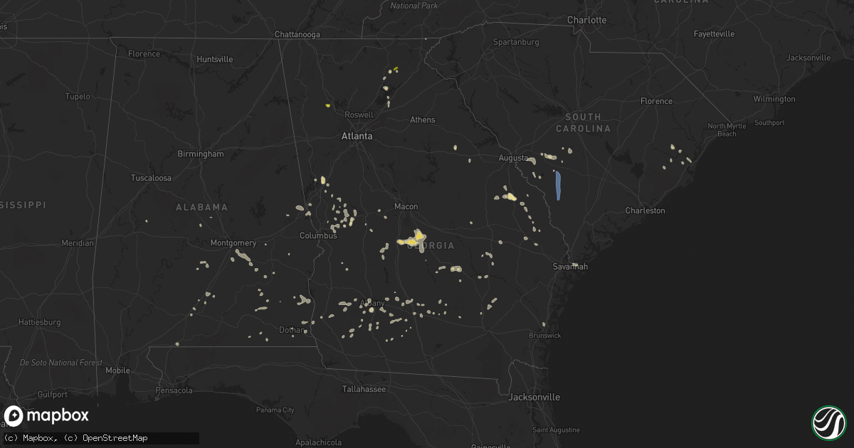
Hail Map in Georgia on June 14, 2022
Get this storm
June 14 map
$229
one time, instant access
Download today. No call, no setup
Keep the $229
Bought the map and want the full workflow? Apply the entire $229 to a subscription within 7 days. None of it is wasted.
Every map, not just this one
This buys you this map. Subscription and you get every map we run, in the markets you choose from a few cities to whole states to nationwide. Plus real-time alerts the moment a storm fires.
Contact data
Name, contact info, occupancy, even credit band for addresses in the footprint. You go from where it hit to who to call.
Become the source they trust
Unlimited branding weather history reports on demand. You already have the documented answer ready for the property owner, and you are the one who showed up with it.
Property data and RoofTrace estimates
Pull up any address you have got, its value and the exact code rules for that jurisdiction, straight from One Click Code. Then RoofTrace estimates the squares, pitch, and roof value, priced the way you price.
Storm reports in Georgia
Georgia
| Date | Description |
|---|---|
| 06/14/20225:50 PM CDT | Ranged from pea to quarter... Lasting approximately 15 minutes. |
| 06/14/20224:48 PM CDT | Report of a tree down on paradise drive in seminole county georgia. |
| 06/14/20224:46 PM CDT | Multiple trees and power poles down across the county. |
| 06/14/20224:45 PM CDT | Tree down across bean avenue in early county georgia. |
| 06/14/20224:45 PM CDT | Downed tree on east 5th street in donaldsonville georgia. |
| 06/14/20224:30 PM CDT | Tree down on north main street in blakely georgia. |
| 06/14/20224:15 PM CDT | Corrects previous tstm wnd dmg report from 2 s bainbridge. Multiple trees and power poles down across the county. |
| 06/14/20224:00 PM CDT | Multiple trees down across baker and miller counties. |
| 06/14/20224:00 PM CDT | Tree down on highway 37 in newton georgia. |
| 06/14/20223:50 PM CDT | Tree down on southbound side of highway 45 in baker county georgia. |
| 06/14/20223:48 PM CDT | Tree blown down across highway 112. Estimated time. |
| 06/14/20223:45 PM CDT | Law enforcement reported broken tree limbs hanging over the road... Roughly 6 miles south of quitman. Location estimated. |
| 06/14/20223:40 PM CDT | Law enforcement reported tree limbs fell on powerlines within city limits of quitman. Location estimated. |
| 06/14/20223:40 PM CDT | Numerous trees and power lines down across the county. |
| 06/14/20223:33 PM CDT | Tree down across dixie highway. |
| 06/14/20223:15 PM CDT | Tree fell on house. |
| 06/14/20222:45 PM CDT | Several large limbs blown into the roadway. Upper portion of one tree snapped and also in roadway. Time estimated by radar. |
| 06/14/20222:45 PM CDT | Worth county dispatch reported a down tree on york rd. |
| 06/14/20222:45 PM CDT | Worth county dispatch reported a down tree on nutt rd. |
| 06/14/20222:40 PM CDT | Worth county law enforcement reported a down tree on sing rd. |
| 06/14/20222:32 PM CDT | Delayed report. Time estimated from radar. Tree down on powerlines on 4th street in brunswick. |
| 06/14/20222:20 PM CDT | Berrien county dispatch reported a down tree on sr-135 |
| 06/14/20222:15 PM CDT | Report of tree down in mobile home park in tift county georgia. |
| 06/14/20222:15 PM CDT | Tree down on wyclif roberts road. |
| 06/14/20221:55 PM CDT | Large tree down and blocking the road leading into the skidaway island institute of oceanography. |
| 06/14/20221:50 PM CDT | Trees down near the intersection of pike and klondike rd |
| 06/14/20221:50 PM CDT | Cema reports a tree down along the 0 block of richmond drive. |
| 06/14/20221:42 PM CDT | Trees down across ellis road |
| 06/14/20221:35 PM CDT | Long county emergency manager reported a tree down on a home on whit frasier rd. Time of event was estimated from radar data. |
| 06/14/20221:35 PM CDT | Cema reports powerlines down at the intersection of waters avenue and east waldburg street. |
| 06/14/20221:35 PM CDT | Long county emergency manager reported that a metal roof was blown off a home on lyndsi ln. Time of event was estimated from radar data. |
| 06/14/20221:30 PM CDT | Trees down blocking elko rd. |
| 06/14/20221:15 PM CDT | Trees down near intersection of scotland road and anderson road. |
| 06/14/20221:10 PM CDT | Cema reports powerlines down at the intersection of skidaway road and 43rd street. |
| 06/14/20221:08 PM CDT | Trees down near intersection of coleman register road and g r register road. |
| 06/14/20221:06 PM CDT | Cema reports a tree down on powerlines at the 600 block of windsor road. |
| 06/14/20221:06 PM CDT | Cema reports a tree down on powerlines at the 600 block of windsor road. |
| 06/14/202212:57 PM CDT | Effingham county 911 center reported a tree down near the intersection of u.s. Highway 80 and pine st. Time of event was estimated from radar data. |
| 06/14/202212:45 PM CDT | Metal roof blown off building |
| 06/14/202212:40 PM CDT | Multiple trees down |
| 06/14/202212:34 PM CDT | Bulloch county 911 call center reported 2 trees down blocking the roadway west of statesboro... On westside road as well as on pulaski hwy. |
| 06/14/202212:34 PM CDT | Bulloch county 911 call center reported a tree down... Blocking the roadway between country club road and west jones ave. |
| 06/14/202212:32 PM CDT | Large tree down along dixon lake road. Blocked one lane of traffic. |
| 06/14/202212:30 PM CDT | Large tree down near intersection of hwy 130 and james howell road. |
| 06/14/202212:25 PM CDT | Bulloch county 911 call center reported a tree down on power lines which caught on fire near the intersection of west hwy 80 and troy polk road. |
| 06/14/202212:18 PM CDT | Bulloch county 911 call center reported a tree down on power lines along ramble road. |
| 06/14/202212:07 PM CDT | Multiple trees were blown down near the intersection of highway 57 and piney grove rd. Time of event was estimated from radar data. |
| 06/14/202212:06 PM CDT | Bulloch county 911 center reported a tree down on west waters lane blocking the roadway. |
| 06/14/202212:00 PM CDT | Burke county dispatch reported a tree down and power outages in midville. Time estimated by radar. |
| 06/14/202211:33 AM CDT | Thunderstorm winds blew down a tree along buttermilk rd near the screven county line. Time of event was estimated from radar data. |
| 06/14/202211:25 AM CDT | Burke county dispatch reported a tree down in girard. Time estimated by radar. |
| 06/14/202210:59 AM CDT | Estimated 1 inch hail around cleveland. |
| 06/14/20227:29 AM CDT | At 1228 PM EDT, severe thunderstorms were located along a line extending from 7 miles northeast of Millen to 6 miles north of Herndon, moving south at 10 mph. HAZARD...60 mph wind gusts and quarter size hail. SOURCE...Radar indicated. IMPACT...Minor hail damage to vehicles is possible. Expect wind damage to trees and powerlines. Locations impacted include: Millen, Sylvania, Butts, Hiltonia, Rocky Ford, Woodcliff, Perkins, Hilltonia, Emmalane, Millhaven, Herndon and Scarboro. |
| 06/14/20227:19 AM CDT | At 1218 PM EDT, a severe thunderstorm was located near War Hill Park, or near Gainesville, moving southwest at 10 mph. HAZARD...60 mph wind gusts and quarter size hail. SOURCE...Radar indicated. IMPACT...Hail damage to vehicles is expected. Expect wind damage to roofs, siding, and trees. Locations impacted include... Gainesville, Flowery Branch, Oakwood, Aqualand Park, Chestatee, Chestnut Mountain, Oscarville and Lake Lanier Islands. |
| 06/14/20226:59 AM CDT | At 1158 AM EDT, severe thunderstorms were located along a line extending from near Bamberg to near Barnwell to near Millett, moving southeast at 25 mph. HAZARD...60 mph wind gusts and penny size hail. SOURCE...Radar indicated. IMPACT...Expect damage to trees and powerlines. Locations impacted include: Allendale, Hampton, Lake Warren State Park, Colleton, Varnville, Fairfax, Brunson, Gifford, Sycamore, Luray, Smoaks, Lodge, Williams, Ulmer and Miley. |
| 06/14/20226:59 AM CDT | At 1158 AM EDT, a severe thunderstorm was located over Garland, or near Dahlonega, moving southwest at 15 mph. HAZARD...60 mph wind gusts and quarter size hail. SOURCE...Trained weather spotters. IMPACT...Hail damage to vehicles is expected. Expect wind damage to roofs, siding, and trees. Locations impacted include... Gainesville, Dahlonega, Cleveland, Lula, Clermont, Murrayville, Camp Coleman Lake, Auraria, Garland, Leaf and Mossy Creek. |
| 06/14/20226:44 AM CDT | At 1144 AM EDT, severe thunderstorms were located along a line extending from 6 miles south of Jackson to near Denmark, moving south at 40 mph. HAZARD...60 mph wind gusts and nickel size hail. SOURCE...Radar indicated. IMPACT...Expect damage to trees and powerlines. Locations impacted include... Barnwell, Denmark, Savannah River Site, Plant Vogtle, Williston, Blackville, New Ellenton, Jackson, Barnwell State Park, Hilda, Snelling, Olar, Kline, Elko, Govan, Audubon's Silver Bluff Sanctuary, Savannah River Site Badge Office, Savannah River Site H Canyon, Savannah River Site K Complex and Shell Bluff Landing. |
| 06/14/20226:42 AM CDT | At 1142 AM EDT, a severe thunderstorm was located over Sandy Cross, or near Crawfordville, moving south at 20 mph. HAZARD...60 mph wind gusts and nickel size hail. SOURCE...Radar indicated. IMPACT...Expect damage to roofs, siding, and trees. Locations impacted include... Crawfordville, Union Point, White Plains, Siloam, Norwood, Sharon, Liberty, Springfield, Veazey, Robinson, Jewell, Mayfield, Daniel Springs, Powelton, Barnett, Lyneville, Raytown, Alexander Stephens Park, Sandy Cross and Carters Grove. |
| 06/14/20226:09 AM CDT | At 1109 AM EDT, severe thunderstorms were located along a line extending from 6 miles northeast of Williston to 6 miles northwest of Jackson, moving south at 20 mph. HAZARD...60 mph wind gusts and quarter size hail. SOURCE...Radar indicated. IMPACT...Hail damage to vehicles is expected. Expect wind damage to trees and powerlines. Locations impacted include... Aiken, North Augusta, Denmark, Aiken Mall, Clearwater, Williston, Blackville, New Ellenton, Jackson, Citizens Park, Gloverville, Barnwell State Park, Aiken State Park, Burnettown, Springfield, Salley, Elko, Windsor, Savannah River Site Badge Office and Aiken Gopher Tortoise Heritage Preserve. |
| 06/14/202212:02 AM CDT | At 502 PM EDT/402 PM CDT/, a severe thunderstorm was located near Abbeville, and is nearly stationary. HAZARD...60 mph wind gusts and penny size hail. SOURCE...Radar indicated. IMPACT...Expect damage to roofs, siding, and trees. Locations impacted include... Abbeville, Fort Gaines, Newville, Haleburg, Shorterville, Walter F. George Lock And Dam, Walter F George Lake, Edwin, Standleys Store, Hayes, Scottsboro Crossroads, Double Bridges, Graball, Dancey, Thomas Mill Creek, Fort Gaines-Clay Airport, Barnes, Hardwickburg, Capps and Otho. |
| 06/13/202211:25 PM CDT | At 424 PM EDT, a severe thunderstorm was located near Edison, or near Morgan, moving southwest at 5 mph. HAZARD...60 mph wind gusts and penny size hail. SOURCE...Radar indicated. IMPACT...Expect damage to roofs, siding, and trees. Locations impacted include... Morgan, Edison, Arlington, Douglasville, Iveys Mill, Parksville, Crestview, Cordrays Mill, Colomokee, Commissary Hill, Turman, Dickey, Rowena and Moye. |
| 06/13/202211:15 PM CDT | At 415 PM EDT, severe thunderstorms were located along a line extending from 9 miles northeast of Pelham to 8 miles northeast of Pavo to 6 miles north of Mayday, moving southwest at 20 mph. HAZARD...60 mph wind gusts and penny size hail. SOURCE...Radar indicated. IMPACT...Expect damage to roofs, siding, and trees. Locations impacted include... Valdosta, Thomasville, Lake Park, Quitman, Hahira, Boston, Ochlocknee, Pavo, Coolidge, I-75 At Exit 16, Moody Air Force Base, Remerton, Dasher, Morven, Barwick, Dillon, Everett, Merrillville, Moultrie Municipal A/P and Empress. |
| 06/13/202210:51 PM CDT | At 351 PM EDT, a severe thunderstorm was located near Albany, moving southwest at 30 mph. HAZARD...60 mph wind gusts. SOURCE...Radar indicated. IMPACT...Expect damage to roofs, siding, and trees. Locations impacted include... Colquitt, Newton, Albany, Pelham, Putney, Camilla, Baconton, Leary, East Albany, Marine Corps Logistics Base, Turner City, Walker, Sale City, Babcock, Iveys Mill, Flint, Radium Springs, Lockett Crossing, South Albany and Southwest Ga Regional A/P. |
| 06/13/202210:49 PM CDT | Multiple trees down or snapped near and along saggus rd causing power outages. |
| 06/13/202210:35 PM CDT | At 335 PM EDT, severe thunderstorms were located along a line extending from 6 miles northwest of Norman Park to 9 miles north of Lakeland, moving south at 15 mph. HAZARD...60 mph wind gusts. SOURCE...Radar indicated. IMPACT...Expect damage to roofs, siding, and trees. Locations impacted include... Nashville, Moultrie, Adel, Lakeland, Valdosta, Hahira, Sparks, Ray City, Norman Park, Lenox, Doerun, Moody Air Force Base, Riverside, Schley, Meigs, Berlin, Funston, Cecil, Ellenton and Reed Bingham State Park. |
| 06/13/202210:19 PM CDT | At 319 PM EDT, a severe thunderstorm was located near Hogansville, or 12 miles northeast of LaGrange, moving south at 15 mph. HAZARD...60 mph wind gusts and quarter size hail. SOURCE...Radar indicated. IMPACT...Hail damage to vehicles is expected. Expect wind damage to roofs, siding, and trees. Locations impacted include... LaGrange, Hogansville, Grantville, Lone Oak, Corinth, Saint Marks, Harrisonville, Louise and Mountville. |
| 06/13/202210:11 PM CDT | At 311 PM EDT, a severe thunderstorm was located near Country Club Estates, or near Dock Junction, moving south at 10 mph. HAZARD...60 mph wind gusts and penny size hail. SOURCE...Radar indicated. IMPACT...Expect damage to roofs, siding, and trees. Locations impacted include... Dock Junction, Country Club Estates and Boys Estate. |
| 06/13/202210:09 PM CDT | At 309 PM EDT, severe thunderstorms were located along a line extending from 12 miles east of Leesburg to near Alapaha, moving south at 10 mph. HAZARD...60 mph wind gusts. SOURCE...Radar indicated. IMPACT...Expect damage to roofs, siding, and trees. Locations impacted include... Tifton, Nashville, Ashburn, Sylvester, Enigma, Omega, Norman Park, Lenox, Poulan, Doerun, Ty Ty, Alapaha, Phillipsburg, Unionville, Terrell, Sycamore, Sumner, Warwick, Minton and Scooterville. |
| 06/13/20229:57 PM CDT | At 257 PM EDT, severe thunderstorms were located along a line extending from Kathleen to Tarversville to Cary, moving north at 5 mph. HAZARD...60 mph wind gusts and nickel size hail. SOURCE...Radar indicated. IMPACT...Expect damage to roofs, siding, and trees. Locations impacted include... Tarversville, District Path, Sand Bed, Goldsboro, Cary, Bonaire, Kathleen and Bullard. |
| 06/13/20229:50 PM CDT | At 250 PM EDT, severe thunderstorms were located along a line extending from 6 miles north of Willacoochee to near Dixie Union, and are moving south at 10 mph. HAZARD...60 mph wind gusts and penny size hail. SOURCE...Radar indicated. IMPACT...Expect damage to roofs, siding, and trees. Locations impacted include... Bickley. |
| 06/13/20229:45 PM CDT | At 245 PM EDT, a severe thunderstorm was located over Klondike, or 7 miles northwest of Hawkinsville, and is nearly stationary. HAZARD...60 mph wind gusts and quarter size hail. SOURCE...Radar indicated. IMPACT...Hail damage to vehicles is expected. Expect wind damage to roofs, siding, and trees. Locations impacted include... Hawkinsville, Hayneville, Browndale, Ocmulgee Public Fishing Area, Mobley Crossing, Hartford, Pulaski State Prison, Magnolia, Klondike and Clinchfield. |
| 06/13/20229:34 PM CDT | At 233 PM CDT, a severe thunderstorm was located over Fairfax, or over Valley, and is nearly stationary. HAZARD...60 mph wind gusts. SOURCE...Radar indicated. IMPACT...Expect damage to roofs, siding, and trees. Locations impacted include... Valley, Lanett, Cusseta, Huguley, Fairfax, I 85 Welcome Center At Lanett and Lanett Municipal Airport. |
| 06/13/20229:29 PM CDT | At 229 PM EDT, severe thunderstorms were located along a line extending from near McRae to near Towns to near Charlotteville, moving north at 10 mph. HAZARD...60 mph wind gusts and quarter size hail. SOURCE...Radar indicated. IMPACT...Hail damage to vehicles is expected. Expect wind damage to roofs, siding, and trees. Locations impacted include... McRae, Helena, Uvalda, Scotland, Alston, Towns, Spring Hill, Jordan and Charlotteville. |
| 06/13/20229:27 PM CDT | At 226 PM EDT, a severe thunderstorm was located near Ambrose, moving southwest at 20 mph. HAZARD...60 mph wind gusts and penny size hail. SOURCE...Radar indicated. IMPACT...Expect damage to roofs, siding, and trees. Locations impacted include... Tifton, Ocilla, Enigma, Alapaha, Mystic, Phillipsburg, Unionville, Vanceville, Gladys, Glory, Harding, Waterloo, Pinetta, Tift Airport, Fender and Brookfield. |
| 06/13/20229:22 PM CDT | At 222 PM EDT, a severe thunderstorm was located over Grovania, or near Perry, and is nearly stationary. HAZARD...60 mph wind gusts and nickel size hail. SOURCE...Radar indicated. IMPACT...Expect damage to roofs, siding, and trees. Locations impacted include... Hawkinsville, Hayneville, Browndale, Ocmulgee Public Fishing Area, Sand Bed, Grovania, Elko, Grove Park, Magnolia, Klondike and Clinchfield. |
| 06/13/20229:09 PM CDT | At 209 PM EDT, a severe thunderstorm was located 7 miles south of Surrency, moving south at 15 mph. HAZARD...60 mph wind gusts and quarter size hail. SOURCE...Radar indicated. IMPACT...Hail damage to vehicles is expected. Expect wind damage to roofs, siding, and trees. Locations impacted include... Alma, Bristol and New Lacy. |
| 06/13/20229:06 PM CDT | At 206 PM EDT, a severe thunderstorm was located near Lowery, or 10 miles south of Dublin, moving southwest at 10 mph. HAZARD...60 mph wind gusts and nickel size hail. SOURCE...Radar indicated. IMPACT...Expect damage to roofs, siding, and trees. Locations impacted include... Dublin, Dexter, Cadwell, Rentz, Lothair, Landsburg, Cedar Grove, Orland, Rockledge, Lowery, Barnhill and Minter. |
| 06/13/20228:34 PM CDT | At 134 PM EDT, a severe thunderstorm was located over Prattsburg, or 9 miles east of Talbotton, and is nearly stationary. HAZARD...60 mph wind gusts and quarter size hail. SOURCE...Radar indicated. IMPACT...Hail damage to vehicles is expected. Expect wind damage to roofs, siding, and trees. Locations impacted include... Talbotton, Woodland, Junction City, Geneva, Pleasant Hill, Howard, Baldwinville, Prattsburg, Big Lazer Creek Wma, Wesley Church, Olive Branch and Po Biddy Crossroads. |
| 06/13/20228:24 PM CDT | At 124 PM EDT, a severe thunderstorm was located over Amicalola Falls State Park, or 11 miles northeast of Jasper, moving west at 10 mph. HAZARD...60 mph wind gusts and quarter size hail. SOURCE...Radar indicated. IMPACT...Hail damage to vehicles is expected. Expect wind damage to roofs, siding, and trees. Locations impacted include... Jasper, Ellijay, Nelson, East Ellijay, Talking Rock, Amicalola Falls State Park, Sequoyah Lake, Talona, Marblehill, Juno, Fausett Lake, Len Foote Hike Inn, Cartecay, Black Gap Shelter, Lake Tamarack, Tate, Roy and Roundtop. |
| 06/13/20228:14 PM CDT | At 114 PM EDT, a severe thunderstorm was located over Vidalia, or near Lyons, moving south at 15 mph. HAZARD...60 mph wind gusts and quarter size hail. SOURCE...Radar indicated. IMPACT...Hail damage to vehicles is expected. Expect wind damage to roofs, siding, and trees. Locations impacted include... Lyons, Vidalia, Uvalda, Higgston, Santa Claus, Alston, Center, Toombs Central, Ponderosa, South Thompson, Rock Springs, Cedar Crossing and Johnson Corner. |
All States Impacted by Hail Map on June 14, 2022
Cities Impacted by Hail Map on June 14, 2022
- Waskish, MN
- Big Falls, MN
- Minocqua, WI
- Granville, IA
- Orange City, IA
- Alton, IA
- Archer, IA
- Hospers, IA
- Ewing, NE
- Kabetogama, MN
- Littlefork, MN
- French Creek, WV
- Ames, IA
- Nevada, IA
- Kelley, IA
- Tallmansville, WV
- Thief River Falls, MN
- Orr, MN
- Lumber City, GA
- Camilla, GA
- Sale City, GA
- Frost, MN
- Buffalo Center, IA
- Bricelyn, MN
- Elmore, MN
- Wells, MN
- Wausau, WI
- Spring Grove, MN
- Dow City, IA
- Caledonia, MN
- Nashua, IA
- Charles City, IA
- Woodward, IA
- Boone, IA
- Adel, IA
- Minburn, IA
- Madrid, IA
- Redfield, IA
- Story City, IA
- Rippey, IA
- Gilbert, IA
- Panora, IA
- Perry, IA
- Ogden, IA
- Dallas Center, IA
- Yale, IA
- Luther, IA
- Linden, IA
- Dawson, IA
- Bouton, IA
- Millville, MN
- Grygla, MN
- Reinbeck, IA
- Cedar Falls, IA
- Dike, IA
- North Loup, NE
- Vienna, MD
- Mardela Springs, MD
- Coon Rapids, IA
- Durand, WI
- Menomonie, WI
- Cusseta, AL
- Valley, AL
- Lanett, AL
- Wolbach, NE
- Scotia, NE
- Greeley, NE
- Plummer, MN
- Oklee, MN
- Erskine, MN
- Mcintosh, MN
- Yuma, CO
- Venango, NE
- Ogallala, NE
- Grant, NE
- East Grand Forks, MN
- Warren, MN
- Parkersburg, IA
- Webster City, IA
- Marshall, NC
- Andrews, SC
- Nesmith, SC
- Hogansville, GA
- Decorah, IA
- Osage, IA
- Rudd, IA
- Plymouth, IA
- Mason City, IA
- Orchard, IA
- Nora Springs, IA
- Lac Du Flambeau, WI
- Thompson, ND
- Fisher, MN
- Thompson, IA
- Lake Mills, IA
- Scarville, IA
- Elcho, WI
- Pittsville, WI
- Black River Falls, WI
- Marshfield, WI
- Arpin, WI
- Warrens, WI
- Casey, IA
- Adair, IA
- Arcadia, NE
- Loup City, NE
- Lincoln, NE
- Walton, NE
- Greenville, GA
- Lagrange, GA
- Wellsburg, IA
- Holland, IA
- Grundy Center, IA
- Scribner, NE
- West Point, NE
- Rockwell City, IA
- Kelliher, MN
- Iowa Falls, IA
- Kesley, IA
- Allison, IA
- Williams, IA
- Hampton, IA
- Dumont, IA
- Dows, IA
- Popejoy, IA
- Aplington, IA
- Alden, IA
- Ackley, IA
- Bradford, IA
- Geneva, IA
- International Falls, MN
- Crookston, MN
- Beltrami, MN
- Ute, IA
- Charter Oak, IA
- Junction City, WI
- Auburndale, WI
- Milladore, WI
- Vesper, WI
- Mosinee, WI
- Merrill, WI
- North, SC
- Newport News, VA
- Tryon, NE
- Colfax, WI
- Elk Mound, WI
- Bovey, MN
- Deerbrook, WI
- Gleason, WI
- Blairsburg, IA
- Cambridge, MD
- Trail, MN
- Gully, MN
- Gonvick, MN
- Goodridge, MN
- Clearbrook, MN
- Neligh, NE
- Clearwater, NE
- Plainview, NE
- Mission Hill, SD
- Utica, SD
- Brunswick, NE
- Center, NE
- Creighton, NE
- Bloomfield, NE
- Crofton, NE
- Yankton, SD
- Royal, NE
- Irene, SD
- Ridgeway, IA
- Lake City, MN
- Wabasha, MN
- Wray, CO
- Holyoke, CO
- Oakwood, GA
- Gainesville, GA
- Waucoma, IA
- Fort Atkinson, IA
- Protivin, IA
- Calmar, IA
- Newfolden, MN
- Dupree, SD
- Champion, NE
- Dahlonega, GA
- Crawfordville, GA
- Denton, NE
- De Witt, NE
- Mabie, WV
- Pickens, WV
- Huttonsville, WV
- Mill Creek, WV
- Pacific Junction, IA
- Cleveland, GA
- Monterville, WV
- Slatyfork, WV
- Valley Head, WV
- Webster Springs, WV
- Marlinton, WV
- Brooklet, GA
- Red Lake Falls, MN
- Monona, IA
- Sac City, IA
- Lake View, IA
- Wall Lake, IA
- Odebolt, IA
- Kiron, IA
- Lytton, IA
- Marshalltown, IA
- Harlan, IA
- Kirkman, IA
- Manilla, IA
- Earling, IA
- Irwin, IA
- Defiance, IA
- New Providence, IA
- Moorefield, NE
- Shell Rock, IA
- New Hampton, IA
- Ionia, IA
- Hallam, NE
- Warrenton, GA
- Hooper, NE
- Uehling, NE
- Oakland, NE
- Talbotton, GA
- Woodland, GA
- Leary, GA
- Morgan, GA
- Edison, GA
- Lyle, MN
- Saint Ansgar, IA
- Northwood, IA
- Kensett, IA
- Grafton, IA
- Austin, MN
- Norman Park, GA
- Sylvania, GA
- Elko, GA
- Eastman, GA
- Cochran, GA
- Kathleen, GA
- Dry Branch, GA
- Hawkinsville, GA
- Perry, GA
- Jeffersonville, GA
- Blackduck, MN
- Blue Hill, NE
- Carleton, NE
- Red Cloud, NE
- Guide Rock, NE
- Deweese, NE
- Edgar, NE
- Davenport, NE
- Bladen, NE
- Oak, NE
- Nelson, NE
- Lawrence, NE
- Bruning, NE
- Tallahassee, FL
- Lyons, GA
- Letohatchee, AL
- Fort Deposit, AL
- Hayneville, AL
- Kermit, TX
- Albany, GA
- Sylvester, GA
- Doerun, GA
- Pleasant Dale, NE
- Milford, NE
- Malvern, IA
- Glenwood, IA
- Snow Hill, MD
- Alapaha, GA
- Fountain, FL
- Flowery Branch, GA
- Waynesboro, GA
- Cartersville, GA
- Williston, SC
- Millen, GA
- Smithfield, WV
- Windsor, SC
- Blackville, SC
- Oakland, IA
- Henderson, IA
- Carson, IA
- Macedonia, IA
- Silver City, IA
- Treynor, IA
- Baxley, GA
- Omega, GA
- Columbia, AL
- Headland, AL
- Ashford, AL
- Butler, GA
- Chula, GA
- Tifton, GA
- Council Bluffs, IA
- Junction City, GA
- Wink, TX
- Fremont, NE
- Bruno, NE
- Hampton, NE
- Bradshaw, NE
- Polk, NE
- Aurora, NE
- Bellwood, NE
- North Bend, NE
- Abie, NE
- Herman, NE
- David City, NE
- Benedict, NE
- Osceola, NE
- Rising City, NE
- Arlington, NE
- Ames, NE
- Winslow, NE
- Stromsburg, NE
- Morse Bluff, NE
- Linwood, NE
- Nickerson, NE
- Shelby, NE
- Liebenthal, KS
- Ness City, KS
- McCracken, KS
- Bazine, KS
- La Crosse, KS
- Alexander, KS
- Bison, KS
- Grand Island, NE
- Lexington, NE
- Overton, NE
- Eldora, IA
- Hubbard, IA
- Bertrand, NE
- Plattsmouth, NE
- Louisville, NE
- Weeping Water, NE
- Griswold, IA
- Emerson, IA
- Garland, NE
- Seward, NE
- Beatrice, NE
- Wood River, NE
- Valparaiso, NE
- Raymond, NE
- Malcolm, NE
- Weston, NE
- Prague, NE
- Mason City, NE
- Pleasanton, NE
- Doniphan, NE
- Trumbull, NE
- Heartwell, NE
- Kenesaw, NE
- Henderson, NE
- Gretna, NE
- Eustis, NE
- Bee, NE
- Fort Calhoun, NE
- Missouri Valley, IA
- Omaha, NE
- Bennet, NE
- Neeses, SC
- Banks, AL
- McRae Helena, GA
- Alamo, GA
- Hardaway, AL
- Ambrose, GA
- Douglas, GA
- Maywood, NE
- Curtis, NE
- Brayton, IA
- Anita, IA
- Atlantic, IA
- Elwood, NE
- Arapahoe, NE
- Smithfield, NE
- Moorland, IA
- Somers, IA
- Phillips, NE
- Saint Hilaire, MN
- Sumner, NE
- Aiken, SC
- Beaver Crossing, NE
- Dorchester, NE
- Friend, NE
- Quantico, MD
- Delmar, MD
- Linkwood, MD
- Hebron, MD
- Fruitland, MD
- East New Market, MD
- Rhodesdale, MD
- Salisbury, MD
- Delmar, DE
- Parsonsburg, MD
- Dillard, GA
- Statesboro, GA
- Troy, AL
- Vidalia, GA
- Woodbury, GA
- Warm Springs, GA
- Manchester, GA
- Moultrie, GA
- Sumner, GA
- Pine Grove, WV
- Kearney, NE
- Minden, NE
- Axtell, NE
- Sutton, NE
- York, NE
- Bethesda, OH
- Barnesville, OH
- Quaker City, OH
- Ravenna, NE
- Kennard, NE
- Hastings, NE
- Lebanon, NE
- Blair, NE
- McClelland, IA
- Litchfield, NE
- Funk, NE
- Oxford, NE
- Brainard, NE
- Holdrege, NE
- Bellevue, NE
- Mead, NE
- Edison, NE
- Elmwood, NE
- Washington, NE
- Ceresco, NE
- Crescent, IA
- Danbury, NE
- Grand Junction, IA
- Waverly, NE
- Bennington, NE
- Hazard, NE
- Holbrook, NE
- Alvo, NE
- Ashton, NE
- Papillion, NE
- Inland, NE
- Marquette, NE
- Fairmont, NE
- Ulysses, NE
- Mineola, IA
- Atlanta, NE
- Jefferson, IA
- Dwight, NE
- Manley, NE
- South Bend, NE
- Waco, NE
- Eagle, NE
- Saronville, NE
- Craig, NE
- Bayard, IA
- Waterloo, NE
- Loomis, NE
- Holstein, NE
- Harvard, NE
- Riverdale, NE
- Clay Center, NE
- Hamlin, IA
- Malmo, NE
- Bagley, IA
- Murray, NE
- Elliott, IA
- Cedar Bluffs, NE
- Stockville, NE
- Juniata, NE
- Cambridge, NE
- Colon, NE
- Guthrie Center, IA
- McCool Junction, NE
- Carter Lake, IA
- Offutt Afb, NE
- Greenwood, NE
- Davey, NE
- Shelton, NE
- Glenvil, NE
- Chapman, NE
- Elba, NE
- Giltner, NE
- Memphis, NE
- Tekamah, NE
- Avoca, NE
- Roseland, NE
- McCook, NE
- Cedar Creek, NE
- La Vista, NE
- Valley, NE
- Hordville, NE
- Staplehurst, NE
- Elkhorn, NE
- Springfield, NE
- Gibbon, NE
- Ashland, NE
- Hancock, IA
- Murdock, NE
- Wahoo, NE
- Red Oak, IA
- Elm Creek, NE
- Bartley, NE
- Walnut, IA
- Lewis, IA
- Exira, IA
- Rockville, NE
- Yutan, NE
- Alda, NE
- Ithaca, NE
- Grafton, NE
- Jamaica, IA
- Utica, NE
- Marne, IA
- Boys Town, NE
- Audubon, IA
- Gresham, NE
- Amherst, NE
- Odessa, NE
- Hamilton, GA
- Opelika, AL
- Leesburg, GA
- Ariton, AL
- Savannah, GA
- Miller, NE
- Georgetown, SC
- Neola, IA
- Underwood, IA
- Trappe, MD
- Fort Stockton, TX
- Shorterville, AL
- Abbeville, AL
- Sardis, GA
- Ozark, AL
- New Brockton, AL
- Jack, AL
- Enterprise, AL
- Minter, AL
- Hartford, AL
- Enigma, GA
- Knoxville, GA
- Roberta, GA
- Wrightsville, GA
- Cass, WV
- Dunmore, WV
- Colquitt, GA
- Newton, GA
- Box Springs, GA
- Ashburn, GA
- Georgiana, AL
- Midville, GA
- Lee, FL
- Live Oak, FL
- Dothan, AL
- Ellerslie, GA
- Cataula, GA
- Midland, GA
- Columbus, GA
- Upatoi, GA
- Ty Ty, GA
- McKenzie, AL
- Wray, GA
- Shiloh, GA
- Damascus, GA
- Arlington, GA
- Blakely, GA
- Lost Creek, WV
- Jane Lew, WV
- Buckhannon, WV
- Bartlett, NE
- Roland, IA
- McCallsburg, IA
- Radcliffe, IA
- New Hartford, IA
- Lu Verne, IA
- Bode, IA
- Hurlock, MD
- Martell, NE
- Firth, NE
- Hickman, NE
- Palmyra, NE
- Pyote, TX
- Montezuma, GA
- Coolidge, GA
- Musella, GA
- Richland, GA
- Hazlehurst, GA
- Pike Road, AL
- Mathews, AL
- Montgomery, AL
- Ramer, AL
- Greenville, AL
- Naples, FL
- Brewton, AL
- Flomaton, AL
- Clopton, AL
- Brundidge, AL
- Evergreen, AL
- Monticello, FL
- Chancellor, AL
- Proctor, WV
- Littleton, WV
- Salem, WV
- Lumberport, WV
- Clarksburg, WV
- New Martinsville, WV
- Center Point, WV
- Jacksonburg, WV
- Folsom, WV
- Burton, WV
- Wallace, WV
- Reader, WV
- Goldsmith, TX
- Notrees, TX
- Andrews, TX
- Rhine, GA
- Milan, GA
- Pine Mountain, GA
- Mershon, GA
- Alma, GA
- Jansen, NE
- Diller, NE
- Jesup, IA
- Elgin, NE
- West Point, GA
- Poquoson, VA
- Yorktown, VA
- Brunswick, GA
- Otis, KS
- Wesley, IA
- Corwith, IA
- Palatka, FL
- Green Cove Springs, FL
- Preston, GA
- Stratford, IA
- Princess Anne, MD
- New Ellenton, SC
- Minden, IA
- Samson, AL
- Ocilla, GA
- Logan, IA
- Hurtsboro, AL
- Surrency, GA
- Avoca, IA
- Barstow, TX
- Waverly Hall, GA
- Greensboro, AL
- Sycamore, GA
- Powhatan Point, OH
- Jacobsburg, OH
- Clarington, OH
- Reynolds, GA
- Willacoochee, GA
- Billingsley, AL
- Pecos, TX
- Byromville, GA
- Jones, AL
- Nicholls, GA
- Pansey, AL
- Mount Clare, WV
- Horner, WV
- Volga, WV
- Filley, NE
- Fairbury, NE
- Durbin, WV
- Green Bank, WV
- Arbovale, WV
- Warwick, GA
- Hawthorne, FL
- Citra, FL
- Metter, GA
- Cobbtown, GA
- Perkins, GA
- Scotland, SD
- Greenbush, MN
- Blue Earth, MN
- Brownell, KS
- Superior, NE
- Goehner, NE
- Viborg, SD
- Hurley, SD
- Ord, NE
- Hastings, IA
- Nehawka, NE
- Ayr, NE
- Campbell, NE
- Crystal Falls, MI
- Amasa, MI
- Iron River, MI
- Long Lake, WI
- Rhinelander, WI
- Argonne, WI
- Concord, NC
- Allendale, SC
- Ulmer, SC
- Olar, SC
- Barnwell, SC
- Fairfax, SC


