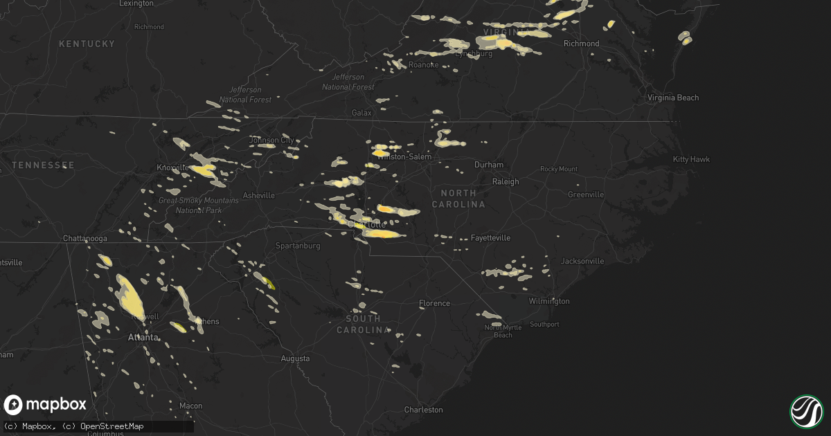
Hail Map in North Carolina on June 13, 2013
Get this storm
June 13 map
$229
one time, instant access
Download today. No call, no setup
Keep the $229
Bought the map and want the full workflow? Apply the entire $229 to a subscription within 7 days. None of it is wasted.
Every map, not just this one
This buys you this map. Subscription and you get every map we run, in the markets you choose from a few cities to whole states to nationwide. Plus real-time alerts the moment a storm fires.
Contact data
Name, contact info, occupancy, even credit band for addresses in the footprint. You go from where it hit to who to call.
Become the source they trust
Unlimited branding weather history reports on demand. You already have the documented answer ready for the property owner, and you are the one who showed up with it.
Property data and RoofTrace estimates
Pull up any address you have got, its value and the exact code rules for that jurisdiction, straight from One Click Code. Then RoofTrace estimates the squares, pitch, and roof value, priced the way you price.
Storm reports in North Carolina
North Carolina
| Date | Description |
|---|---|
| 06/13/20136:45 PM CDT | Bladen co e.m. Reported tree down 2 mi nw of ammon - time estimated based on radar |
| 06/13/20136:45 PM CDT | Tideland electric coop reported a tree down on railroad bed road. Time based on radar. |
| 06/13/20136:33 PM CDT | A local report indicates 62 MPH wind near ELIZABETH CITY BEACH |
| 06/13/20136:31 PM CDT | Bladen co. 911 reported tree down on fl mcdaniel road - time estimated based on radar |
| 06/13/20136:30 PM CDT | Numerous trees down county-wide. Hardest hit area was clinton. |
| 06/13/20136:24 PM CDT | A local report indicates 65 MPH wind near ELIZABETH CITY |
| 06/13/20136:19 PM CDT | Greens cross raws...time estimated from radar. |
| 06/13/20136:11 PM CDT | Tree down on kelly rd and fallen creek rd |
| 06/13/20136:11 PM CDT | Powerlines down on green haynes rd |
| 06/13/20136:05 PM CDT | Tree down btw pine bush rd and sutton rd |
| 06/13/20136:03 PM CDT | Minor structural damage to farm...multiple trees snapped and uprooted |
| 06/13/20136:00 PM CDT | Trees blown down across camden road |
| 06/13/20135:58 PM CDT | Peak wind 61 mph at kfbg. |
| 06/13/20135:51 PM CDT | A local report indicates 61 MPH wind near FT BRAGG SIMMONS AAF |
| 06/13/20135:49 PM CDT | Power lines down at mcintosh and mclaughlin roads. |
| 06/13/20135:49 PM CDT | A local report indicates 60 MPH wind near 1 ENE MOUNT OLIVE |
| 06/13/20135:49 PM CDT | Tree down along aberdeen road |
| 06/13/20135:45 PM CDT | Numerous trees and power lines blown down...especially across the north half of the county |
| 06/13/20135:45 PM CDT | Large pecan tree 2ft diameter down with minor structural damage to residence. |
| 06/13/20135:40 PM CDT | Roof damage and chimney blown off of a home |
| 06/13/20135:40 PM CDT | Multiple trees snapped |
| 06/13/20135:40 PM CDT | Multiple trees snapped between wahlstonburg and stantonsburg |
| 06/13/20135:36 PM CDT | Several trees blown down in raeford |
| 06/13/20135:35 PM CDT | Numerous trees and power lines blown down...especially across the north half of the county |
| 06/13/20135:35 PM CDT | Trees down near goldsboro |
| 06/13/20135:30 PM CDT | Numerous trees downed in colerain along elm grove rd. |
| 06/13/20135:26 PM CDT | Trees down near fremont |
| 06/13/20135:25 PM CDT | Numerous trees blown down especially over the south half of the county |
| 06/13/20135:23 PM CDT | 4 power poles down on railroad tracks |
| 06/13/20135:23 PM CDT | A local report indicates 1.00 inch wind near STALLINGS |
| 06/13/20135:21 PM CDT | Peak wind of 59 mph at krwi |
| 06/13/20135:21 PM CDT | Along ryals street |
| 06/13/20135:20 PM CDT | Numerous trees and power lines were reported down across the county. |
| 06/13/20135:20 PM CDT | Tree blown down across rains crossroads road near princeton-kenly road |
| 06/13/20135:20 PM CDT | Exterior metal door frame damaged at nash community college in rocky mount |
| 06/13/20135:16 PM CDT | Trees down near ranch road |
| 06/13/20135:15 PM CDT | A local report indicates 1.75 inch wind near 4 N MONROE |
| 06/13/20135:15 PM CDT | Numerous trees down in laurinburg and wagram. |
| 06/13/20135:15 PM CDT | Widespread area of trees down and trees on houses in unionville. |
| 06/13/20135:15 PM CDT | Multiple trees blown down near highway 210 and old fairgrounds road |
| 06/13/20135:14 PM CDT | A local report indicates 1.00 inch wind near 13 N MONROE |
| 06/13/20135:14 PM CDT | Estimated 50 mph wind. |
| 06/13/20135:13 PM CDT | A local report indicates 1.25 inch wind near INDIAN TRAIL |
| 06/13/20135:10 PM CDT | Tin roof blown off smithfield pre own car dealership |
| 06/13/20135:10 PM CDT | Trees down across crantock road in clayton |
| 06/13/20135:10 PM CDT | Telephone pole blocking roadway with large tree limb knocking down a powerline |
| 06/13/20135:08 PM CDT | 10 inch diameter tree has pulled down powerline partially blocking hwy 39. |
| 06/13/20135:07 PM CDT | 35-foot tall tree partially uprooted and on a house...plus a 20-foot branch blown down. Another tree landed on and severely damaged a mobile home. |
| 06/13/20135:06 PM CDT | Several trees and tree limbs down on 100 lynn hils drive near richardson road and hwy 231 |
| 06/13/20135:06 PM CDT | Observed along lawyers road. |
| 06/13/20135:05 PM CDT | Tree down in a yard |
| 06/13/20135:05 PM CDT | Several trees blown down |
| 06/13/20135:05 PM CDT | Tree down at mccormick drive and buffalo road |
| 06/13/20135:02 PM CDT | Tree down on power lines |
| 06/13/20135:00 PM CDT | Large tree limbs blown down along indian creek trail |
| 06/13/20135:00 PM CDT | Tree uprooted |
| 06/13/20135:00 PM CDT | Tree down |
| 06/13/20135:00 PM CDT | Oak tree blown down and power lines blown down along cross street. Time estimated. |
| 06/13/20135:00 PM CDT | Power lines down on road |
| 06/13/20135:00 PM CDT | Tree down on finch avenue |
| 06/13/20135:00 PM CDT | Several trees down and blocking roadway. |
| 06/13/20135:00 PM CDT | Forty-foot tree blown down on second street |
| 06/13/20135:00 PM CDT | Powerlines blown down across the road |
| 06/13/20135:00 PM CDT | Railraod traffic signal arms have broken at hwy 42 east and business 70. |
| 06/13/20134:58 PM CDT | Pine tree and large limbs blown down along air park drive near highway 401 |
| 06/13/20134:58 PM CDT | Two hardwood trees blown down |
| 06/13/20134:57 PM CDT | Downed trees and power lines with trees on houses across troy |
| 06/13/20134:56 PM CDT | Trees down on guy road and route 42 west |
| 06/13/20134:56 PM CDT | Trees down on powerlines at business 70 and town center blvd in clayton |
| 06/13/20134:55 PM CDT | Tree down near wendell |
| 06/13/20134:55 PM CDT | Trees down on powerlines at business 70 and town center blvd in clayton |
| 06/13/20134:55 PM CDT | Scattered trees blown down |
| 06/13/20134:51 PM CDT | Two trees blown down at buffaloe road and william and mary drive |
| 06/13/20134:51 PM CDT | Trees down on rocky fort road |
| 06/13/20134:51 PM CDT | Numerous trees down across the road at rawls church road and kennebeck road |
| 06/13/20134:50 PM CDT | Tree blown down along gregory drive |
| 06/13/20134:50 PM CDT | Tree blown down and blocking road at mitchell mill and watkins roads |
| 06/13/20134:50 PM CDT | Twenty-foot tall tree blown down. Time estimated. |
| 06/13/20134:50 PM CDT | Trees down on guy road and route 42 west |
| 06/13/20134:50 PM CDT | Trees blown down around lake tillery. |
| 06/13/20134:50 PM CDT | Power lines and large tree blown down on glenwood road near five points |
| 06/13/20134:50 PM CDT | Large oak tree blown down on bluebird court and jones franklin road |
| 06/13/20134:49 PM CDT | 2 trees sheared off and a half dozen down around the neighborhood near 165 bayberry woods drive |
| 06/13/20134:49 PM CDT | Pine tree blown down and blocking highway 55 eastbound near carpenter fire station road |
| 06/13/20134:49 PM CDT | Tree down at 4800 shoshoni court in garner |
| 06/13/20134:47 PM CDT | Tree down |
| 06/13/20134:47 PM CDT | Tree down on a house on old stage road |
| 06/13/20134:47 PM CDT | Trees down and on powerlines in lee county on hickory avenue near sanford |
| 06/13/20134:47 PM CDT | Roof of industrial carport collapsed at pruitt lumber co. Trees and power lines down across the area. |
| 06/13/20134:45 PM CDT | Tree and large limbs blown down |
| 06/13/20134:45 PM CDT | Trees uprooted |
| 06/13/20134:45 PM CDT | Large maple tree blown down on home |
| 06/13/20134:45 PM CDT | Multiple trees down near lake tillery |
| 06/13/20134:45 PM CDT | Quarter size hail on woodlawn road. |
| 06/13/20134:45 PM CDT | Snapped tree on power lines at fayetteville and manor ridge road. |
| 06/13/20134:45 PM CDT | 30-foot tall tree blown down along jones franklin road |
| 06/13/20134:43 PM CDT | Multiple trees down on lake wheeler road |
| 06/13/20134:43 PM CDT | Five 20-24 inch diameter trees down at ten-ten road and deer meadow drive |
| 06/13/20134:42 PM CDT | Multiple trees down in the franklinton area |
| 06/13/20134:42 PM CDT | 8 to 12 inch diameter tree down. |
| 06/13/20134:42 PM CDT | Scattered trees blown down and power outages |
| 06/13/20134:41 PM CDT | A local report indicates 1.75 inch wind near 1 S CONCORD |
| 06/13/20134:40 PM CDT | Dispatch reported 2 trees downed across the county. |
| 06/13/20134:40 PM CDT | Tree blown down on a power line near lumley road and interstate 540 |
| 06/13/20134:40 PM CDT | A local report indicates 63 MPH wind near 5 SSW ROLESVILLE |
| 06/13/20134:40 PM CDT | Trees down on deberry mill rd |
| 06/13/20134:40 PM CDT | *** 3 inj *** county emergency manager reports numerous trees down county-wide. Albemarle hardest hit. Numerous trees blown down on homes...several of which went throug |
| 06/13/20134:38 PM CDT | Tree down |
| 06/13/20134:38 PM CDT | Tree across greystone road in henderson |
| 06/13/20134:38 PM CDT | Tree split in half across the intersection of rex way and lake boone trail |
| 06/13/20134:38 PM CDT | Trees down on rocky fort road |
| 06/13/20134:36 PM CDT | Tree down and roof blown off a mobile home |
| 06/13/20134:35 PM CDT | Four-foot diameter tree...60 feet high...blown down |
| 06/13/20134:33 PM CDT | Multiple trees down in the centerville area |
| 06/13/20134:32 PM CDT | At least one tree blown down at apex community park |
| 06/13/20134:32 PM CDT | Powerlines across twin creek road in apex. |
| 06/13/20134:32 PM CDT | Trees down and on powerlines in lee county on hickory avenue near sanford |
| 06/13/20134:32 PM CDT | Trees blown down along cameron pond drive |
| 06/13/20134:32 PM CDT | Several large limbs blown down |
| 06/13/20134:32 PM CDT | Multiple trees blown down at carpenter fire station road and highway 55 |
| 06/13/20134:32 PM CDT | Tree blown down along ymca drive. Time estimated based on earlier reports. |
| 06/13/20134:30 PM CDT | Powerline down near davis and caviston in morrisville |
| 06/13/20134:30 PM CDT | 18 in. Diameter... 30 ft tall maple sheared off 5 ft from ground on walcott way in cary |
| 06/13/20134:26 PM CDT | Several large branches blown down and pwr outages. |
| 06/13/20134:25 PM CDT | Many trees down countywide |
| 06/13/20134:25 PM CDT | 8 trees down at central regional hospital in butner |
| 06/13/20134:22 PM CDT | Tree through a house along morningside dr. |
| 06/13/20134:20 PM CDT | Large poplar tree snapped and fell on fence in autumn acres. |
| 06/13/20134:20 PM CDT | Multiple trees reported down in the northeastern portion of chatham county |
| 06/13/20134:20 PM CDT | *** 1 inj *** tree blown down on franklin street. |
| 06/13/20134:20 PM CDT | Numerous trees down near the preserve |
| 06/13/20134:20 PM CDT | Multiple reports of trees and utility lines down...some on cars and houses...across concord. |
| 06/13/20134:18 PM CDT | Multiple trees down around the pittsboro area |
| 06/13/20134:18 PM CDT | Trees down along durham lane. |
| 06/13/20134:17 PM CDT | Pine tree blown down on highway 98 and olive branch road |
| 06/13/20134:15 PM CDT | *** 1 fatal *** a large tree was blown down on the 300 block of east franklin street killing a 20 year old female. |
| 06/13/20134:11 PM CDT | A local report indicates 70 MPH wind near ROUGEMONT |
| 06/13/20134:11 PM CDT | Numerous trees and power lines blown down along red mountain road |
| 06/13/20134:10 PM CDT | Large tree and power lines blown down along hampton road |
| 06/13/20134:10 PM CDT | Concord airport |
| 06/13/20134:05 PM CDT | Numerous trees and power lines down across northern vance county |
| 06/13/20134:05 PM CDT | Scattered trees blown down along hurdle mills road |
| 06/13/20134:00 PM CDT | Large limbs blown down at carr elementary school and at trade and walnut streets. |
| 06/13/20134:00 PM CDT | Multiple trees reported down in and around siler city |
| 06/13/20133:59 PM CDT | Observed along hwy 321 and radio st |
| 06/13/20133:58 PM CDT | Several large trees down |
| 06/13/20133:58 PM CDT | A roof and a porch were blown off of a home near prospect hill. Caswell warning point also reported 100s of trees down across the county between 430 and 500 pm...the ex |
| 06/13/20133:58 PM CDT | 2 power poles down |
| 06/13/20133:55 PM CDT | Five 12 to 14 inch diameter trees down |
| 06/13/20133:54 PM CDT | Tree down |
| 06/13/20133:54 PM CDT | Trees down on homes... Front porch steps ripped off |
| 06/13/20133:52 PM CDT | Trees down along lorey farm road. |
| 06/13/20133:50 PM CDT | Many trees down around the roxboro area |
| 06/13/20133:50 PM CDT | Trees down |
| 06/13/20133:50 PM CDT | Tree on house on parkview circle |
| 06/13/20133:48 PM CDT | Scattered trees blown down |
| 06/13/20133:46 PM CDT | Trees down. |
| 06/13/20133:46 PM CDT | Trees down. |
| 06/13/20133:45 PM CDT | Large tree downed onto a home on nutcracker lane |
| 06/13/20133:45 PM CDT | Numerous reports of trees down across the county. |
| 06/13/20133:45 PM CDT | A couple trees down in rockwell. |
| 06/13/20133:42 PM CDT | Tree down across bear poplar road. |
| 06/13/20133:40 PM CDT | Widespread trees down across the entire county |
| 06/13/20133:36 PM CDT | Multiple trees down |
| 06/13/20133:35 PM CDT | Trees down. |
| 06/13/20133:30 PM CDT | Numerous trees down across the northern part of the county. Highway 29 and highway 86 were blocked in several places by fallen trees. Motorists were stranded in their v |
| 06/13/20133:27 PM CDT | Trees snapped and uprooted. |
| 06/13/20133:26 PM CDT | 3 trees down near browns summit |
| 06/13/20133:25 PM CDT | Tree on house. |
| 06/13/20133:21 PM CDT | Tree down... Time estimated by radar |
| 06/13/20133:20 PM CDT | Lxfn7 raws reported wind gust to 64 mph. |
| 06/13/20133:20 PM CDT | Multiple trees down... Including one on a transformer |
| 06/13/20133:20 PM CDT | Scattered trees down across the county...especially north-central part. |
| 06/13/20133:15 PM CDT | Trees down along hunter pond lane. |
| 06/13/20133:15 PM CDT | Forsyth co reports damage county wide... Many trees and power lines down... Worst is in the northwest. |
| 06/13/20133:15 PM CDT | Newspaper reported numerous trees blown down in the big creek area of the great smoky mountains. Several trails have been closed due to being impassable. Possible torna |
| 06/13/20133:15 PM CDT | Trees down on i-40...traffic was stopped. |
| 06/13/20133:15 PM CDT | Widespread wind damage countywide. 83 reports of downed trees and powerlines. 7400 customers without power across the county. Wind reports began around 350 pm in the no |
| 06/13/20133:12 PM CDT | Several large limbs blown down in statesville. |
| 06/13/20133:12 PM CDT | 2 trees down at weather ridge road and weather ridge ct |
| 06/13/20133:11 PM CDT | Trees down. |
| 06/13/20133:10 PM CDT | Numerous trees reported down on west side of statesville. |
| 06/13/20133:10 PM CDT | Nws storm survey found part of an ef1 tornado track in the big creek area of the great smoky mountains national park. See caepnsgsp for details. |
| 06/13/20133:10 PM CDT | Multiple trees down off hwy 70.awnings and siding torn off houses. |
| 06/13/20133:07 PM CDT | Tree down on a house... People trapped inside |
| 06/13/20133:07 PM CDT | Trees downed and snapped along taylorsville rd. |
| 06/13/20133:06 PM CDT | Numerous trees were blown down in the lecho park sub-division near thornburg dr and rock barn rd. One home was destroyed and others were damaged by fallen trees. |
| 06/13/20133:05 PM CDT | Up to 1 inch hail in sheffield. |
| 06/13/20133:04 PM CDT | Tree down on sixth street |
| 06/13/20133:03 PM CDT | Reports of golf ball sized hail along county home road on the north side of conover. |
| 06/13/20133:02 PM CDT | Trees down on route 700. |
| 06/13/20133:02 PM CDT | Dozen trees down. One fell on a house. |
| 06/13/20133:02 PM CDT | County home road was declared a catastrophy area by an insurance company due to numerous trees down with some trees on houses. A brick chimney was blown over onto a hou |
| 06/13/20133:00 PM CDT | Damage to a shed... Hurricane straps were snapped. Time estimated by radar. |
| 06/13/20132:58 PM CDT | 1 inch hail and strong wind gusts. |
| 06/13/20132:56 PM CDT | 50 knot wind gust recorded at int |
| 06/13/20132:55 PM CDT | Trees down in boone. |
| 06/13/20132:48 PM CDT | Numerous reports of trees down at 1610 bright leaf road in pfafftown. |
| 06/13/20132:46 PM CDT | A local report indicates 59 MPH wind near LONGVIEW |
| 06/13/20132:46 PM CDT | Trees down along cape hickory rd |
| 06/13/20132:45 PM CDT | Also trees down on gap lane |
| 06/13/20132:41 PM CDT | Several trees blown down. |
| 06/13/20132:39 PM CDT | Power lines down along drexel rd. |
| 06/13/20132:39 PM CDT | 1 inch hail and strong wind gusts reported in drexel. |
| 06/13/20132:38 PM CDT | A local report indicates 1.00 inch wind near YADKINVILLE |
| 06/13/20132:38 PM CDT | Trees down on four houses. |
| 06/13/20132:35 PM CDT | A local report indicates 1.00 inch wind near N YADKINVILLE |
| 06/13/20132:35 PM CDT | Some damage to cars |
| 06/13/20132:30 PM CDT | Trees down off st marys church rd and hwy 181. |
| 06/13/20132:30 PM CDT | Several reports of trees and utility lines down...some on houses...countywide. |
| 06/13/20132:22 PM CDT | 50-100 trees down along pleasant hill drive and blue ridge avenue in pleasant hill. Winds estimated 60 mph for 2-3 minutes. |
| 06/13/20132:20 PM CDT | Trees down off packs hill road north of morganton. |
| 06/13/20132:19 PM CDT | *** 1 fatal *** firefighter electrocuted by a downed powerline. |
| 06/13/20132:18 PM CDT | Numerous trees and powerlines down in elkin area |
| 06/13/20132:15 PM CDT | 2 trees down |
| 06/13/20132:15 PM CDT | At 1124 bethany ford rd large trees and limbs down |
| 06/13/20132:07 PM CDT | *** 1 fatal *** tree fell on an elderly man as he walked across his yard. |
| 06/13/20131:56 PM CDT | One tree reported down off hwy 80 east of bakersville. |
| 06/13/20131:50 PM CDT | 2 trees down on deep ford rd |
| 06/13/20131:50 PM CDT | Tree down |
| 06/13/20131:50 PM CDT | Tree down at rec center |
| 06/13/20131:48 PM CDT | Two trees down near laurel. |
| 06/13/20131:41 PM CDT | One tree reported down in maggie valley. |
| 06/13/20131:35 PM CDT | Tree down on cutshall road |
| 06/12/201311:45 PM CDT | Intersection of longwood rd and etheridge rd |
| 06/12/201310:00 PM CDT | Large tree across road near long creek fire dept - time estimated based on radar |
| 06/12/20139:40 PM CDT | Boykin bridge road briefly closed due to downed trees across the road |
| 06/12/20139:34 PM CDT | Report of half dollar sized hail on harrelson rd. |
| 06/12/20138:30 PM CDT | Tree down at us hwy 301 and w green springs rd - time estimated based on radar |
| 06/12/20137:48 PM CDT | One large tree was reported down across strother road... Near ashemont road. |
| 06/12/20137:45 PM CDT | Tree blown down on a house. Time based on radar. |
| 06/12/20137:22 PM CDT | Tree down on power line reported at hwy 11 and red tip ln - time estimated based on radar |
| 06/12/20137:10 PM CDT | Half dollar size hail reported at gibson dairy rd and mercer mill rd - time estimated based on radar |
| 06/12/20137:05 PM CDT | Quarter to half dollar size hail reported at us hwy 701 and harrelson rd - time estimated based on radar |
All States Impacted by Hail Map on June 13, 2013
Cities Impacted by Hail Map on June 13, 2013
- Big Timber, MT
- Wilsall, MT
- Ridgeway, SC
- Maryville, TN
- Tallassee, TN
- Townsend, TN
- Suches, GA
- Lehigh Acres, FL
- Big Springs, NE
- Brundidge, AL
- Manning, SC
- Sumter, SC
- Knoxville, TN
- Bessemer City, NC
- Haxtun, CO
- Reed Point, MT
- Rapelje, MT
- Zapata, TX
- Roma, TX
- Mineral, VA
- Orange, VA
- Crook, CO
- Sedgwick, CO
- Chadds Ford, PA
- Harrodsburg, KY
- Danville, KY
- Junction City, KY
- Perryville, KY
- Idalia, CO
- Stratton, CO
- Kirk, CO
- Walkerton, VA
- Saint Stephens Church, VA
- Bruington, VA
- Dunnsville, VA
- Morganton, GA
- Callaway, MD
- Lusby, MD
- Leonardtown, MD
- Great Mills, MD
- California, MD
- Valley Lee, MD
- Hollywood, MD
- Lexington Park, MD
- Patuxent River, MD
- Dowell, MD
- Solomons, MD
- Owenton, KY
- Axton, VA
- Broadview, MT
- Lavina, MT
- Ryegate, MT
- Tarboro, NC
- Greenville, NC
- Albemarle, NC
- New London, NC
- Gunlock, KY
- Snow Camp, NC
- Graham, NC
- Fleming, CO
- Saint Albans, WV
- Scott Depot, WV
- Hurricane, WV
- Preston, GA
- Buena Vista, GA
- Newark, DE
- Lincoln University, PA
- West Grove, PA
- Wilmington, DE
- Hockessin, DE
- Avondale, PA
- Landenberg, PA
- Kennett Square, PA
- Toughkenamon, PA
- Conowingo, MD
- Whiteford, MD
- Darlington, MD
- Anderson, SC
- Honea Path, SC
- Belton, SC
- Williamston, SC
- Midway, TN
- Bulls Gap, TN
- Mosheim, TN
- Mohawk, TN
- Acton, MT
- Shawmut, MT
- Melville, MT
- Musselshell, MT
- Shepherd, MT
- Worden, MT
- Colby, KS
- Levant, KS
- Atwood, KS
- Herndon, KS
- Oberlin, KS
- Brewster, KS
- Coolville, OH
- Pomeroy, OH
- Flint Hill, VA
- Washington, VA
- Painter, VA
- Cartersville, GA
- Marietta, GA
- Kennesaw, GA
- Roswell, GA
- Ranger, GA
- White, GA
- Woodstock, GA
- Waleska, GA
- Acworth, GA
- Ball Ground, GA
- Fairmount, GA
- Canton, GA
- Clearmont, WY
- Decker, MT
- Sheridan, WY
- Conyers, GA
- Charlotte, NC
- Mount Holly, NC
- Stanley, NC
- Harrisburg, NC
- Gastonia, NC
- Belmont, NC
- Huntersville, NC
- Walker, WV
- Buckingham, VA
- Gladstone, VA
- Wingina, VA
- Stanford, KY
- Fishing Creek, MD
- Vesuvius, VA
- Roseland, VA
- Andalusia, AL
- Holstein, NE
- Roseland, NE
- Ayr, NE
- Manchester, MD
- Colstrip, MT
- Forsyth, MT
- Cave Spring, GA
- Cedartown, GA
- Pinnacle, NC
- Billings, MT
- Sevierville, TN
- Cosby, TN
- Dandridge, TN
- Kodak, TN
- Newport, TN
- Byers, CO
- Roundup, MT
- Harmony, NC
- Hamptonville, NC
- Birmingham, AL
- Chillicothe, OH
- Seymour, TN
- Rutledge, GA
- Rocky Ford, CO
- Winnsboro, SC
- New Windsor, MD
- Finksburg, MD
- Reisterstown, MD
- Union Bridge, MD
- Westminster, MD
- Hickory, NC
- Conover, NC
- Five Points, AL
- Fort Davis, TX
- Rock, WV
- Lashmeet, WV
- Spanishburg, WV
- Beeson, WV
- Hardin, MT
- Crow Agency, MT
- Rosebud, MT
- Busby, MT
- Volborg, MT
- Marietta, PA
- Mount Joy, PA
- Columbia, PA
- Newland, NC
- Big Creek, KY
- Oneida, KY
- Manchester, KY
- Appomattox, VA
- Dillwyn, VA
- Spotsylvania, VA
- Partlow, VA
- Bumpass, VA
- Tyler, MN
- Ruthton, MN
- Bowdon, GA
- Fort Smith, MT
- Saint Xavier, MT
- Lodge Grass, MT
- Garryowen, MT
- Glyndon, MD
- Keymar, MD
- Farmville, VA
- Cumberland, VA
- Madison Heights, VA
- Concord, VA
- Amherst, VA
- Blue Ridge, VA
- Montvale, VA
- Coleman Falls, VA
- Big Island, VA
- Natural Bridge Station, VA
- Bedford, VA
- Ranchester, WY
- Bybee, TN
- Meridian, MS
- Greycliff, MT
- Pendleton, SC
- Liberty, SC
- Elizabethtown, NC
- Bladenboro, NC
- Clarkton, NC
- Vinton, OH
- Fork Union, VA
- Bremo Bluff, VA
- Gilmore City, IA
- Campton, KY
- Millville, NJ
- Bridgeton, NJ
- Ruther Glen, VA
- Beaverdam, VA
- Montpelier, VA
- Wild Horse, CO
- Kit Carson, CO
- Old Fort, TN
- Cleveland, TN
- Hamilton, OH
- Oak Vale, MS
- Alpine, TX
- Timberlake, NC
- Sabina, OH
- Wray, CO
- Campbell, NE
- Juniata, NE
- Kenesaw, NE
- Bladen, NE
- Minden, NE
- Heartwell, NE
- Hastings, NE
- Miles City, MT
- Moon, VA
- Basin, WY
- Otto, WY
- Burlington, WY
- Madisonville, TN
- Tellico Plains, TN
- Custer, MT
- Burlington, CO
- Bethune, CO
- Felton, PA
- Wrightsville, PA
- York, PA
- Red Lion, PA
- Windsor, PA
- Dawsonville, GA
- Rockville, VA
- Manakin Sabot, VA
- Moorefield, NE
- Stockville, NE
- Due West, SC
- Greenwood, SC
- Abbeville, SC
- Browns Summit, NC
- Gibsonville, NC
- Elon, NC
- Burlington, NC
- Reidsville, NC
- Troy, AL
- Narrows, VA
- Parkman, WY
- Timmonsville, SC
- Marathon, TX
- Monticello, GA
- Covington, GA
- Greenwich, NJ
- Vineland, NJ
- Indianola, NE
- Bartley, NE
- Quarryville, PA
- Kirkwood, PA
- Christiana, PA
- Odenville, AL
- Springville, AL
- Tallassee, AL
- Notasulga, AL
- Dadeville, AL
- Camp Hill, AL
- Roberts, MT
- Blountsville, AL
- Blacksburg, VA
- Moneta, VA
- Paris, KY
- Elizabethton, TN
- Cody, WY
- Dahlonega, GA
- Arvonia, VA
- Akron, CO
- Sterling, CO
- Otis, CO
- Guysville, OH
- Shade, OH
- Albany, OH
- Athens, OH
- Wayside, WV
- Thomaston, GA
- Meansville, GA
- Molena, GA
- Hoffman, NC
- Garland, NC
- Woodrow, CO
- Forsyth, GA
- Jonesville, VA
- Seneca, SC
- Central, SC
- Fort Valley, GA
- Cochranville, PA
- Bostic, NC
- Adairsville, GA
- Dacula, GA
- Lawrenceville, GA
- Grayson, GA
- Loganville, GA
- Monroe, GA
- Huntley, MT
- Gillsville, GA
- Gainesville, GA
- Talmo, GA
- Laurel, MT
- Joliet, MT
- Greybull, WY
- Shell, WY
- Manderson, WY
- Julesburg, CO
- Clay Center, NE
- Rydal, GA
- Jasper, GA
- Talking Rock, GA
- Resaca, GA
- Calhoun, GA
- Atlanta, GA
- Rockmart, GA
- Pfafftown, NC
- Eden, NC
- Martinsville, VA
- Tuckasegee, NC
- Gray, GA
- McArthur, OH
- Ray, OH
- Philadelphia, TN
- Sweetwater, TN
- Marion, AL
- Haigler, NE
- Surgoinsville, TN
- Eidson, TN
- Jonesborough, TN
- Limestone, TN
- Telford, TN
- Unicoi, TN
- Saint Francis, KS
- Ridgeway, VA
- Statesville, NC
- Hysham, MT
- Ingomar, MT
- Red Lodge, MT
- Kannapolis, NC
- Mount Pleasant, NC
- Concord, NC
- Dallas, GA
- Buchanan, GA
- Temple, GA
- Aragon, GA
- Parkersburg, WV
- Washington, WV
- Little Hocking, OH
- Maxwelton, WV
- White Sulphur Springs, WV
- Lewisburg, WV
- Renick, WV
- Williamsburg, WV
- Frankford, WV
- Holly Hill, SC
- Eutawville, SC
- Centreville, AL
- Yadkinville, NC
- East Bend, NC
- Boonville, NC
- Lutherville Timonium, MD
- Owings Mills, MD
- Cockeysville, MD
- Hamilton, GA
- Pigeon Forge, TN
- Covington, VA
- Hot Springs, VA
- Rockingham, NC
- Marston, NC
- Lynchburg, VA
- Monroe, VA
- Drayden, MD
- Tall Timbers, MD
- Park Hall, MD
- Marshall, NC
- Bloomfield, KY
- Delta, PA
- Franklin, GA
- Hogansville, GA
- Pendergrass, GA
- Woodford, VA
- Port Royal, VA
- Fredericksburg, VA
- Rappahannock Academy, VA
- Hillsville, VA
- Laurel Fork, VA
- Columbus, MT
- Livingston, MT
- Villa Rica, GA
- Rocky Face, GA
- Tunnel Hill, GA
- Chatsworth, GA
- Ringgold, GA
- Dalton, GA
- Radford, VA
- Jarrettsville, MD
- Street, MD
- Forest Hill, MD
- Wagram, NC
- Laurinburg, NC
- Whipple, OH
- Cherokee, NC
- Church Hill, MD
- Sudlersville, MD
- Peebles, OH
- Delmont, NJ
- Raeford, NC
- Exmore, VA
- Quinby, VA
- Belle Haven, VA
- Melfa, VA
- Middlebourne, WV
- Molt, MT
- Stinnett, KY
- Hyden, KY
- Macon, GA
- Hampton, GA
- Stockbridge, GA
- Mcdonough, GA
- Le Roy, WV
- Roan Mountain, TN
- Bakersville, NC
- Midland, NC
- Montgomery, AL
- Louisa, VA
- Bogart, GA
- Athens, GA
- Dorchester, NE
- Crete, NE
- Watkinsville, GA
- Statham, GA
- Punta Gorda, FL
- Monroe, NC
- Crouse, NC
- Dallas, NC
- Matthews, NC
- Kings Mountain, NC
- Peachland, NC
- Casar, NC
- Lincolnton, NC
- Wingate, NC
- Indian Trail, NC
- Cherryville, NC
- Lawndale, NC
- Pineville, NC
- Marshville, NC
- Cramerton, NC
- Shelby, NC
- Camden, SC
- New Park, PA
- Airville, PA
- Stewartstown, PA
- Omaha, GA
- Lumpkin, GA
- Nixon, TX
- Claremont, NC
- Laurel, MS
- Shubuta, MS
- Marshall, VA
- Rileyville, VA
- Hume, VA
- Huntly, VA
- Luray, VA
- Bentonville, VA
- Friendsville, TN
- Greenback, TN
- Philadelphia, PA
- Willard, NC
- Peachtree Corners, GA
- Louisville, MS
- Newnan, GA
- Christiansburg, VA
- Altoona, AL
- Oneonta, AL
- Germanton, NC
- Walnut Cove, NC
- Belews Creek, NC
- Dugspur, VA
- Willis, VA
- Belpre, OH
- Reedsville, OH
- Belleville, WV
- Mineral Wells, WV
- Booneville, KY
- Huddleston, VA
- Lynch Station, VA
- Edgar, MT
- Bridger, MT
- Moravian Falls, NC
- Taylorsville, NC
- Lenoir, NC
- Boomer, NC
- Mount Vernon, KY
- Ballantine, MT
- Fall Branch, TN
- Union Springs, AL
- Foster, WV
- Peytona, WV
- Powder Springs, TN
- Washburn, TN
- Luttrell, TN
- Maynardville, TN
- Talladega, AL
- Chickamauga, GA
- Pipestem, WV
- Jumping Branch, WV
- King, NC
- Tobaccoville, NC
- Gresham, NE
- Waco, NE
- Armuchee, GA
- Summerville, GA
- Morrow, GA
- Jonesboro, GA
- Stromsburg, NE
- Blacksburg, SC
- Smyrna, SC
- Reliance, TN
- Fackler, AL
- Woodland, AL
- Heflin, AL
- Graham, AL
- Ranburne, AL
- Ellisville, MS
- Bishop, GA
- Unadilla, NE
- Butler, AL
- Toxey, AL
- Holbrook, NE
- Arapahoe, NE
- Lawrenceburg, KY
- Chaplin, KY
- Edgewater, MD
- Annapolis, MD
- Riva, MD
- Davidsonville, MD
- Knoxville, GA
- Frederick, MD
- Quitman, MS
- Vossburg, MS
- Willisburg, KY
- Ellerbe, NC
- Elba, AL
- Unionville, VA
- Centre, AL
- Jackson, KY
- Atglen, PA
- Parkesburg, PA
- Plainview, NE
- Neligh, NE
- Newport, VA
- Donalds, SC
- London, KY
- Beach Haven, NJ
- McCormick, SC
- Warner Robins, GA
- The Rock, GA
- Nancy, KY
- Irvine, KY
- Ravenna, KY
- New Canton, VA
- Columbia, VA
- Chuckey, TN
- Bearcreek, MT
- Belfry, MT
- Culbertson, NE
- Maywood, NE
- McCook, NE
- Elk Park, NC
- Banner Elk, NC
- Bandy, VA
- North Tazewell, VA
- Arcadia, FL
- Cuba, AL
- Ward, AL
- Westhoff, TX
- Cincinnati, OH
- Loveland, OH
- Coffeeville, AL
- Thomasville, AL
- Oak Hill, WV
- Fayetteville, WV
- Vale, NC
- Buchanan, VA
- Summersville, WV
- Great Falls, SC
- Talmage, NE
- Fitzgerald, GA
- Gordonsville, VA
- King George, VA
- Colonial Beach, VA
- Ordway, CO
- Coatesville, PA
- Downingtown, PA
- West Chester, PA
- Thorndale, PA
- Eastover, SC
- Lugoff, SC
- Columbia, SC
- Port Elizabeth, NJ
- Richmond, KY
- Kinzers, PA
- Gap, PA
- Egg Harbor Township, NJ
- Longport, NJ
- Linwood, NJ
- Margate City, NJ
- Somers Point, NJ
- Ocean City, NJ
- Ivanhoe, NC
- Council, NC
- Atkinson, NC
- Kelly, NC
- Gulston, KY
- Cawood, KY
- Harlan, KY
- Mary Alice, KY
- Woodbine, NJ
- Olin, NC
- Fort Peck, MT
- Brodhead, KY
- Yuma, CO
- Eclectic, AL
- New Marshfield, OH
- Richfield, NC
- Concord, GA
- Gay, GA
- Cartersville, VA
- Powhatan, VA
- Oceana, WV
- Fawn Grove, PA
- Pylesville, MD
- Lovell, WY
- Onancock, VA
- Hacksneck, VA
- Carson, MS
- Columbia, MS
- Burnsville, NC
- Princeton, WV
- Athens, WV
- Lerona, WV
- Winston Salem, NC
- Lovingston, VA
- Schuyler, VA
- Shipman, VA
- Sandy Hook, VA
- Howardsville, VA
- Goochland, VA
- Palmyra, VA
- Gum Spring, VA
- Maidens, VA
- Scottsville, VA
- Esmont, VA
- Hoschton, GA
- Jefferson, GA
- Winder, GA
- Cambridge, NE
- Roscoe, MT
- Fromberg, MT
- Wiggins, CO
- Mackville, KY
- Springfield, KY
- Rock Hall, MD
- Chestertown, MD
- Centreville, MD
- Morganton, NC
- Beaverton, AL
- Silver Creek, GA
- Lindale, GA
- Maiden, NC
- Newton, NC
- Lebanon, OH
- Franklin, OH
- Holland, MN
- Lake Benton, MN
- Church Creek, MD
- Cambridge, MD
- Brogue, PA
- Claymont, DE
- Somerset, KY
- Meeteetse, WY
- Bidwell, OH
- Benkelman, NE
- Jordan, MT
- Cohagen, MT
- Fonda, IA
- Mebane, NC
- Orlando, KY
- Maryville, MO
- Skidmore, MO
- Saint Matthews, SC
- Stony Point, NC
- Kokomo, MS
- Foxworth, MS
- Londonderry, OH
- Macfarlan, WV
- Petroleum, WV
- Harrisville, WV
- Hillsboro, OH
- Blue Hill, NE
- Glenvil, NE
- Fairfield, NE
- Livingston, AL
- Epes, AL
- Holdrege, NE
- Summerfield, NC
- Annville, KY
- Clarkesville, GA
- Mount Sterling, KY
- Otter, MT
- Amelia Court House, VA
- Ruffin, NC
- La Follette, TN
- Williamson, GA
- Cranks, KY
- Grays Knob, KY
- Lanett, AL
- Medford, NJ
- Cherry Hill, NJ
- Voorhees, NJ
- Marlton, NJ
- Gonzales, TX
- Pierce, NE
- Ellijay, GA
- Yoakum, TX
- Cuero, TX
- Crestwood, KY
- Auburn, WV
- Hampstead, MD
- Upperco, MD
- Pendleton, KY
- Lumberton, NC
- Hamden, OH
- Bryson City, NC
- Trenton, NE
- Beattyville, KY
- Ocoee, TN
- Taneytown, MD
- White Hall, MD
- Parkton, MD
- Glenville, PA
- Glen Rock, PA
- Hanover, PA
- Seven Valleys, PA
- Sparks Glencoe, MD
- Spring Grove, PA
- Bainbridge, OH
- Middletown, OH
- Benton, TN
- Delano, TN
- Iron Station, NC
- Alexis, NC
- Waverly, OH
- Sandyville, WV
- Ripley, WV
- Mocksville, NC
- Brierfield, AL
- Mount Airy, MD
- Monrovia, MD
- New Market, MD
- Polkton, NC
- Cleveland, AL
- Bremen, GA
- Eustis, NE
- Camden, OH
- Carlton, GA
- Milligan, NE
- Friend, NE
- Atlanta, NE
- Iva, SC
- Goodwater, AL
- Millerville, AL
- White Pine, TN
- New Milton, WV
- Nicholasville, KY
- Sumrall, MS
- Mooresville, NC
- Linwood, NC
- Lexington, NC
- Woodbury Heights, NJ
- Clarksboro, NJ
- Paulsboro, NJ
- Swedesboro, NJ
- Rockland, DE
- Chester, PA
- Woodbury, NJ
- Sewell, NJ
- Westville, NJ
- Pedricktown, NJ
- Yorklyn, DE
- Montchanin, DE
- Glen Mills, PA
- Mullica Hill, NJ
- Garnet Valley, PA
- Aston, PA
- Mickleton, NJ
- Crum Lynne, PA
- Thorofare, NJ
- Wenonah, NJ
- Gibbstown, NJ
- Marcus Hook, PA
- Mantua, NJ
- Mount Royal, NJ
- Bridgeport, NJ
- New Castle, VA
- Peach Bottom, PA
- Seminary, MS
- Albertson, NC
- Pink Hill, NC
- Rose Hill, NC
- Mineral Bluff, GA
- Chattanooga, TN
- Rossville, GA
- Greeneville, TN
- La Grange, KY
- Bagdad, KY
- Shelbyville, KY
- Smithfield, KY
- Eminence, KY
- Pleasureville, KY
- Cost, TX
- York, AL
- Tuskegee, AL
- Shorter, AL
- Bent Mountain, VA
- La Fayette, GA
- King William, VA
- Lee, FL
- Blaine, TN
- Strawberry Plains, TN
- New Market, TN
- Springdale, MT
- Lisman, AL
- Clintwood, VA
- Salem, WV
- Blanchester, OH
- Pleasant Plain, OH
- Goshen, OH
- Floyd, VA
- Roopville, GA
- Greensboro, NC
- Benedict, NE
- Lancaster, PA
- Lexington, VA
- Russell Springs, KY
- Troutville, VA
- Catawba, VA
- Salem, VA
- Lewisville, NC
- New Zion, SC
- Holly Pond, AL
- Shiloh, NJ
- Salem, NJ
- Selden, KS
- Rexford, KS
- Stratton, NE
- Max, NE
- Frankfort, OH
- Whiteville, NC
- Elwood, NE
- Thaxton, VA
- Clemson, SC
- Forest Park, GA
- Campbellsburg, KY
- Sulphur, KY
- Turners Station, KY
- New Castle, KY
- Crawley, WV
- Pelzer, SC
- Piedmont, SC
- Barbourville, KY
- Bimble, KY
- Flat Lick, KY
- Walkersville, MD
- Harrells, NC
- Vance, AL
- Seale, AL
- Marion Junction, AL
- Fayetteville, OH
- Forest, VA
- Daleville, VA
- Goode, VA
- Beverly, KY
- Georgetown, KY
- Stamping Ground, KY
- Sadieville, KY
- Bird In Hand, PA
- Smoketown, PA
- Ronks, PA
- Elgin, SC
- Blythewood, SC
- Alum Creek, WV
- McLeod, MT
- Glen Arm, MD
- Parkville, MD
- Towson, MD
- Ovid, CO
- Marble, NC
- Murphy, NC
- Pinewood, SC
- Wedgefield, SC
- Pineville, KY
- Carrollton, GA
- Fort Morgan, CO
- Florence, AL
- Muscle Shoals, AL
- Troy, NC
- Copperhill, TN
- Parrottsville, TN
- Pike Road, AL
- Enterprise, MS
- Trion, GA
- Spruce Pine, AL
- Phil Campbell, AL
- Arvada, WY
- Needham, AL
- Gilbertown, AL
- Joppa, MD
- Upper Falls, MD
- Perry Hall, MD
- Kingsville, MD
- Soso, MS
- Perry Park, KY
- Buckhead, GA
- Madison, GA
- Fitzpatrick, AL
- Ramer, AL
- Grady, AL
- Mathews, AL
- Conway, SC
- Longs, SC
- Loris, SC
- Albion, NE
- Clover, SC
- Vincentown, NJ
- Rogersville, TN
- Sneedville, TN
- Thorn Hill, TN
- Vinton, VA
- Easley, SC
- Salem, SC
- Hartford, TN
- Wilmington, OH
- Charles City, VA
- Henrico, VA
- Hiram, GA
- Silas, AL
- Taylorsville, GA
- Del Rio, TN
- Buena Vista, VA
- Rural Hall, NC
- Elliston, VA
- Murrayville, GA
- Kenova, WV
- Cowen, WV
- Camden On Gauley, WV
- Milford, VA
- Scottsboro, AL
- Woodville, AL
- Blackstock, SC
- Richburg, SC
- Pioneer, TN
- Newcomb, TN
- Jamestown, TN
- Tamassee, SC
- Leeds, AL
- Seward, NE
- Glenwood, AL
- Lynn, AL
- Clifton Forge, VA
- Hurdle Mills, NC
- Castlewood, VA
- Phoenix, MD
- Gambrills, MD
- Bowie, MD
- Hiawassee, GA
- Brookville, IN
- North, VA
- Foster, VA
- Runnemede, NJ
- Blackwood, NJ
- Brookhaven, PA
- Ridley Park, PA
- Chester Heights, PA
- Glendora, NJ
- Thornton, PA
- Woodlyn, PA
- Media, PA
- Leesville, SC
- Gilbert, SC
- Malta, OH
- Stockport, OH
- Lexington, KY
- Chatsworth, NJ
- Union Mills, NC
- Elizabeth, WV
- Audubon, NJ
- Glassboro, NJ
- Somerdale, NJ
- Drumore, PA
- Glenolden, PA
- Wallingford, PA
- Bellmawr, NJ
- Mount Ephraim, NJ
- Folsom, PA
- New Freedom, PA
- Rising Sun, MD
- North East, MD
- Holmes, PA
- Barrington, NJ
- Haddon Heights, NJ
- Shrewsbury, PA
- Pitman, NJ
- Grenloch, NJ
- Springfield, PA
- Darby, PA
- Essington, PA
- Clifton Heights, PA
- Gloucester City, NJ
- Prospect Park, PA
- Oxford, PA
- Norwood, PA
- Sharon Hill, PA
- Morton, PA
- Lansdowne, PA
- Folcroft, PA
- Elkton, MD
- Swarthmore, PA
- Clementon, NJ
- National Park, NJ
- Nottingham, PA
- Prichard, WV
- Wayne, WV
- Marmora, NJ
- Curtis, NE
- Hayes Center, NE
- Westboro, MO
- Port Charlotte, FL
- Greenfield, OH
- Leesburg, OH
- Washington Court House, OH
- Pembroke, VA
- Leighton, AL
- Conestoga, PA
- Pequea, PA
- Rustburg, VA
- Bluefield, WV
- Wallins Creek, KY
- Powell, WY
- Badin, NC
- New Matamoras, OH
- Friendly, WV
- Crab Orchard, KY
- Waynesburg, KY
- Bowling Green, VA
- Perry, FL
- Macclenny, FL
- Catawba, NC
- Decatur, GA
- Coltons Point, MD
- Dayton, WY
- Montross, VA
- State Road, NC
- Elkin, NC
- Kingston, GA
- Rome, GA
- Granite Falls, NC
- Hildebran, NC
- Connelly Springs, NC
- La Junta, CO
- Sunset, SC
- Nebo, NC
- Wolfcreek, WV
- Advance, NC
- Cope, CO
- Joes, CO
- Sardinia, OH
- West Chester, OH
- Fairfield, OH
- Anselmo, NE
- Bradley, SC
- Bird City, KS
- Rutherfordton, NC
- Haleyville, AL
- Sharpsburg, GA
- Senoia, GA
- Greenville, FL
- Cullowhee, NC
- Lithonia, GA
- Dozier, AL
- Vernon, CO
- Columbus, MS
- Sharps Chapel, TN
- Braselton, GA
- Stoneville, NC
- Liberty, NC
- Julian, NC
- Fort Mill, SC
- Rock Hill, SC
- Ellicott City, MD
- Decherd, TN
- Gatlinburg, TN
- Jefferson City, TN
- Berea, KY
- Paint Lick, KY
- Point Pleasant, WV
- Wellston, OH
- Wilkesville, OH
- Bolton, NC
- Riegelwood, NC
- Oakboro, NC
- Stanfield, NC
- Locust, NC
- Sugar Grove, NC
- Vilas, NC
- Hillsboro, GA
- Richwood, WV
- Craigsville, WV
- Nettie, WV
- Fenwick, WV
- Tallapoosa, GA
- Waco, GA
- West Blocton, AL
- Valley Head, AL
- Locust Grove, GA
- Lindside, WV
- Greenville, WV
- Jay Em, WY
- Warne, NC
- Hayesville, NC
- Sherrills Ford, NC
- Whitsett, NC
- Urbanna, VA
- Roanoke, AL
- Tabor City, NC
- Sparta, TN
- Loudon, TN
- Vonore, TN
- Norwood, NC
- Duffield, VA
- Blackwater, VA
- Bassfield, MS
- Utica, NE
- Simpsonville, KY
- Staplehurst, NE
- Whitesburg, GA
- Galivants Ferry, SC
- Alcoa, TN
- Louisville, TN
- Kyles Ford, TN
- Pemberton, NJ
- Pennington, AL
- Sweet Water, AL
- Clarks, NE
- Aberdeen, MS
- Axtell, NE
- Wilcox, NE
- Sterrett, AL
- Red Springs, NC
- Lynchburg, OH
- Pearisburg, VA
- Butler, TN
- Dundalk, MD
- Sparrows Point, MD
- Essex, MD
- Wedowee, AL
- Blairsville, GA
- Madison, FL
- Wilmington, NC
- Germantown, OH
- Lagrange, GA
- Forest, MS
- Wolbach, NE
- Hinton, WV
- Nimitz, WV
- Okolona, MS
- Catlettsburg, KY
- Burgaw, NC
- Ashland, VA
- Doswell, VA
- Church Hill, TN
- Gate City, VA
- Avenue, MD
- Newburg, MD
- Abell, MD
- Bushwood, MD
- Cobb Island, MD
- Rocky Ridge, MD
- Thurmont, MD
- Woodsboro, MD
- Sugar City, CO
- Swink, CO


