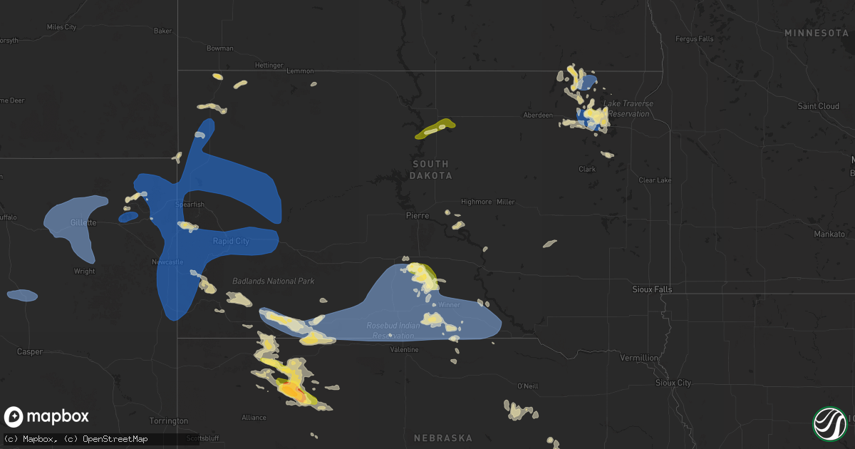
Hail Map in South Dakota on August 13, 2025
Get this storm
August 13 map
$229
one time, instant access
Download today. No call, no setup
Keep the $229
Bought the map and want the full workflow? Apply the entire $229 to a subscription within 7 days. None of it is wasted.
Every map, not just this one
This buys you this map. Subscription and you get every map we run, in the markets you choose from a few cities to whole states to nationwide. Plus real-time alerts the moment a storm fires.
Contact data
Name, contact info, occupancy, even credit band for addresses in the footprint. You go from where it hit to who to call.
Become the source they trust
Unlimited branding weather history reports on demand. You already have the documented answer ready for the property owner, and you are the one who showed up with it.
Property data and RoofTrace estimates
Pull up any address you have got, its value and the exact code rules for that jurisdiction, straight from One Click Code. Then RoofTrace estimates the squares, pitch, and roof value, priced the way you price.
Storm reports in South Dakota
South Dakota
| Date | Description |
|---|---|
| 08/13/20256:51 PM CDT | A local report indicates 64 MPH wind near 3 NW Wasta |
| 08/13/20256:35 PM CDT | A local report indicates 64 MPH wind near 2 E Elm Springs |
| 08/13/20256:35 PM CDT | A local report indicates 62 MPH wind near 10 W Reva |
| 08/13/20256:31 PM CDT | A local report indicates 58 MPH wind near 3 NW Wasta |
| 08/13/20256:15 PM CDT | A local report indicates 58 MPH wind near 11 SSE Hereford |
| 08/13/20256:14 PM CDT | A local report indicates 62 MPH wind near 3 W Union Center |
| 08/13/20256:05 PM CDT | A local report indicates 69 MPH wind near 6 WSW Fairpoint |
| 08/13/20256:00 PM CDT | A local report indicates 63 MPH wind near Ellsworth AFB |
| 08/13/20255:59 PM CDT | A local report indicates 61 MPH wind near 1 W Box Elder |
| 08/13/20255:58 PM CDT | A local report indicates 63 MPH wind near Ellsworth AFB |
| 08/13/20255:55 PM CDT | A local report indicates 64 MPH wind near 3 N Redig |
| 08/13/20255:52 PM CDT | A local report indicates 59 MPH wind near Ellsworth AFB |
| 08/13/20255:38 PM CDT | A local report indicates 60 MPH wind near Piedmont |
| 08/13/20255:35 PM CDT | A local report indicates 59 MPH wind near 7 E Sturgis |
| 08/13/20255:30 PM CDT | A local report indicates 58 MPH wind near 1 NNW Nisland |
| 08/13/20255:27 PM CDT | A local report indicates 60 MPH wind near 7 SW Custer |
| 08/13/20255:24 PM CDT | A local report indicates 58 MPH wind near 12 WSW Castle Rock |
| 08/13/20255:24 PM CDT | A local report indicates 60 MPH wind near 10 W Edgemont |
| 08/13/20255:15 PM CDT | Time estimated based on radar |
| 08/13/20255:14 PM CDT | A local report indicates 60 MPH wind near 10 W Edgemont |
| 08/13/20259:38 AM CDT | Nickel to quarter sized hail. |
| 08/13/20252:48 AM CDT | Mesonet station 179 sd rwis tyndall. |
| 08/13/20252:30 AM CDT | Wind damaged awn |
| 08/13/20252:30 AM CDT | Wind damaged awning on a camper trailer. |
| 08/13/20252:05 AM CDT | Fire department reported numerous trees down in roslyn. Time estimated by radar. |
| 08/13/20252:00 AM CDT | Winds estimated at 60 mph... Hail around nickel size... Wind driven hail caused damage to crops. |
| 08/13/20251:00 AM CDT | A local report indicates 58 MPH wind near 4 ENE Langford |
| 08/13/202512:30 AM CDT | A local report indicates 69 MPH wind near 5 SSE Pierpont |
| 08/13/202512:15 AM CDT | A |
| 08/13/202512:15 AM CDT | Awos station kbtn 1 nne britton. |
| 08/12/202511:43 PM CDT | Report of a large branch down from an apple tree. Time estimated by radar. |
| 08/12/202511:15 PM CDT | Dime to quarter size hail reported for a duration of 10 minutes. Time estimated by radar. |
| 08/12/202510:40 PM CDT | Corrects previous tstm wnd gst report from 15 wnw platte. Mesonet station acms2 academy 3nnw |
| 08/12/202510:40 PM CDT | Mesonet station acms2 academy 3nnw. |
| 08/12/202510:36 PM CDT | Trained spotter reported 1 inch hail and minor wind damage to crops and trees. |
| 08/12/202510:31 PM CDT | Personal weather station. |
| 08/12/202510:12 PM CDT | Corrects previous tstm wnd gst report from 7 sse dallas. Mesonet station ggms2 gregory 7ssw |
| 08/12/202510:12 PM CDT | Mesonet station ggms2 gregory 7ssw. |
| 08/12/20259:58 PM CDT | A local report indicates 68 MPH wind near Wewela |
| 08/12/20259:55 PM CDT | A local report indicates 61 MPH wind near 1 NE Winner |
| 08/12/20259:52 PM CDT | A local report indicates 59 MPH wind near 1 NE Winner |
| 08/12/20259:46 PM CDT | Mesonet station 285 14w lower brule |
| 08/12/20259:38 PM CDT | A local report indicates 58 MPH wind near 4 SSE Witten |
| 08/12/20259:30 PM CDT | Mesonet station rfps2 vivian 13 n. Time estimated. |
| 08/12/20259:13 PM CDT | A local report indicates 65 MPH wind near 15 SSE Mission |
| 08/12/20259:08 PM CDT | A local report indicates 62 MPH wind near 15 SSE Mission |
| 08/12/20259:05 PM CDT | A local report indicates 62 MPH wind near 7 ESE Rosebud |
| 08/12/20259:05 PM CDT | Estimated 50 to 60 mph wind gusts. |
| 08/12/20258:55 PM CDT | Mesonet station vvms2 vivian 12s |
| 08/12/20258:40 PM CDT | A local report indicates 58 MPH wind near 1 NE Midland |
| 08/12/20258:36 PM CDT | A local report indicates 71 MPH wind near 11 SW Parmelee |
| 08/12/20258:35 PM CDT | A local report indicates 76 MPH wind near 3 NNE Harrington |
| 08/12/20258:35 PM CDT | A local report indicates 63 MPH wind near 1 S White River |
| 08/12/20258:33 PM CDT | A local report indicates 59 MPH wind near 10 NNE White River |
| 08/12/20258:30 PM CDT | A local report indicates 64 MPH wind near 12 S Vivian |
| 08/12/20258:21 PM CDT | Report from mping: quarter |
| 08/12/20258:15 PM CDT | A local report indicates 64 MPH wind near 1 NE Midland |
| 08/12/20258:15 PM CDT | A local report indicates 59 MPH wind near 4 ENE Martin |
| 08/12/20258:11 PM CDT | A local report indicates 59 MPH wind near 9 ENE Belvidere |
| 08/12/20258:10 PM CDT | A local report indicates 61 MPH wind near 1 NE Midland |
| 08/12/20258:10 PM CDT | A local report indicates 63 MPH wind near 4 WNW Cedar Butte |
| 08/12/20258:03 PM CDT | A local report indicates 59 MPH wind near 7 E Wanblee |
| 08/12/20257:53 PM CDT | A local report indicates 60 MPH wind near 7 E Wanblee |
| 08/12/20257:51 PM CDT | A local report indicates 58 MPH wind near 4 E Cactus Flat |
| 08/12/20257:43 PM CDT | A local report indicates 63 MPH wind near 7 E Wanblee |
| 08/12/20257:41 PM CDT | A local report indicates 66 MPH wind near 4 E Cactus Flat |
| 08/12/20257:33 PM CDT | A local report indicates 68 MPH wind near 9 SW Batesland |
| 08/12/20257:32 PM CDT | A local report indicates 62 MPH wind near 3 E Philip |
| 08/12/20257:31 PM CDT | A local report indicates 69 MPH wind near 4 E Cactus Flat |
| 08/12/20257:30 PM CDT | A local report indicates 59 MPH wind near 5 NW Kadoka |
| 08/12/20257:30 PM CDT | (u |
| 08/12/20257:28 PM CDT | A local report indicates 67 MPH wind near 9 SW Batesland |
| 08/12/20257:21 PM CDT | A local report indicates 64 MPH wind near 7 NNE Ralph |
| 08/12/20257:21 PM CDT | A local report indicates 70 MPH wind near 4 E Cactus Flat |
| 08/12/20257:16 PM CDT | A local report indicates 62 MPH wind near 4 E Cactus Flat |
| 08/12/20257:13 PM CDT | A local report indicates 65 MPH wind near 6 W Cottonwood |
| 08/12/20257:11 PM CDT | A local report indicates 65 MPH wind near 7 NNE Ralph |
| 08/12/20257:05 PM CDT | A local report indicates 65 MPH wind near 6 ESE Scenic |
| 08/12/20257:03 PM CDT | A local report indicates 63 MPH wind near 6 W Cottonwood |
| 08/12/20257:00 PM CDT | A local report indicates 67 MPH wind near Howes |
All States Impacted by Hail Map on August 13, 2025
Cities Impacted by Hail Map on August 13, 2025
- Wolf Point, MT
- Selby, SD
- Gettysburg, SD
- Eagle Butte, SD
- Akaska, SD
- Java, SD
- Bowdle, SD
- Voorheesville, NY
- East Berne, NY
- Clarksville, NY
- Ravena, NY
- Selkirk, NY
- Feura Bush, NY
- Coeymans Hollow, NY
- Oak Hill, NY
- East Durham, NY
- Greenville, NY
- Jefferson, NY
- Harpersfield, NY
- Cornwallville, NY
- Westerlo, NY
- Delmar, NY
- Davenport, NY
- Freehold, NY
- Alcove, NY
- Schenevus, NY
- Worcester, NY
- Cairo, NY
- Acra, NY
- Woodland, MS
- Round Top, NY
- Houston, MS
- West Point, MS
- Lampasas, TX
- San Saba, TX
- Arlington, VT
- East Arlington, VT
- Manchester Center, VT
- Lititz, PA
- Hot Springs National Park, AR
- Maben, MS
- Parkersburg, WV
- Manchester, VT
- Gandeeville, WV
- Malvern, AR
- Mineral Wells, WV
- Manheim, PA
- Gorman, TX
- Danville, AR
- Silver Springs, FL
- Lagrangeville, NY
- Dexter, MO
- Buffalo, WY
- Gillette, WY
- Rozet, WY
- Imboden, AR
- Verbank, NY
- Lancaster, PA
- Hopewell Junction, NY
- Moorcroft, WY
- Weston, WY
- Hartman, AR
- Coal Hill, AR
- Clarksville, AR
- Ravenden, AR
- Roland, OK
- Pleasant Valley, NY
- Millbrook, NY
- Hastings, FL
- Muldrow, OK
- Poteau, OK
- Townsend, MA
- Pepperell, MA
- Bird In Hand, PA
- Leola, PA
- Daytona Beach, FL
- Kent, CT
- New Preston Marble Dale, CT
- Groton, MA
- Shirley, MA
- Fort McCoy, FL
- Belle Glade, FL
- Wynne, AR
- Sikeston, MO
- Brookline, NH
- Devils Tower, WY
- Kaycee, WY
- Midwest, WY
- Casper, WY
- Sundance, WY
- Patton, MO
- Sedgewickville, MO
- Howe, OK
- Hollis, NH
- Dunstable, MA
- Malta, ID
- Laurel, MS
- Ellisville, MS
- Jonesboro, AR
- Upton, WY
- Hulett, WY
- Alva, WY
- Beulah, WY
- Aladdin, WY
- Osage, WY
- Newcastle, WY
- Clermont, FL
- White Marsh, MD
- Perry Hall, MD
- Sedona, AZ
- Jacksonville, FL
- Amherst, NH
- Merrimack, NH
- Bedford, NH
- Hill City, SD
- Lead, SD
- Spearfish, SD
- Belle Fourche, SD
- Wiergate, TX
- Weare, NH
- Hillsborough, NH
- Fredericksburg, TX
- Hilliard, FL
- Callahan, FL
- Kingsville, MD
- Folkston, GA
- Stonewall, TX
- Upper Falls, MD
- Custer, SD
- Lance Creek, WY
- Edgemont, SD
- Florien, LA
- Boerne, TX
- Deadwood, SD
- Conde, SD
- Groton, SD
- Como, MS
- Sarah, MS
- Senatobia, MS
- Coldwater, MS
- Hornbeck, LA
- Lake, MS
- Hot Springs, SD
- Bonneau, SC
- Lumberton, MS
- Buffalo, SD
- Pringle, SD
- Brooklyn, MS
- Wiggins, MS
- Nisland, SD
- Vale, SD
- Newell, SD
- Saint Onge, SD
- Piedmont, SD
- Box Elder, SD
- Rapid City, SD
- Nemo, SD
- Black Hawk, SD
- Keystone, SD
- Hermosa, SD
- Buffalo Gap, SD
- Fairburn, SD
- Caputa, SD
- Ellsworth Afb, SD
- Stigler, OK
- Quinton, OK
- Andover, SD
- Oral, SD
- Wister, OK
- Boxford, MA
- Middleton, MA
- North Andover, MA
- New Underwood, SD
- Mud Butte, SD
- Union Center, SD
- Sturgis, SD
- Bristol, SD
- Jonesboro, LA
- Chatham, LA
- Fort Stewart, GA
- Longwood, FL
- Enning, SD
- Owanka, SD
- Wasta, SD
- Howes, SD
- White Owl, SD
- Draper, SD
- Ludlow, SD
- Bloomingdale, GA
- Reva, SD
- Oelrichs, SD
- Altamonte Springs, FL
- Casselberry, FL
- Maitland, FL
- Pine Ridge, SD
- Chadron, NE
- Swanzey, NH
- Ralph, SD
- McHenry, MS
- Guyton, GA
- Rushville, NE
- Hay Springs, NE
- Stamford, NY
- Manderson, SD
- Wounded Knee, SD
- Batesland, SD
- Porcupine, SD
- Hillside, NJ
- Linden, NJ
- Elizabethport, NJ
- Elizabeth, NJ
- Roselle, NJ
- Staten Island, NY
- Bayonne, NJ
- Newark, NJ
- Jersey City, NJ
- Kearny, NJ
- Wallace, SD
- Bradley, SD
- Gordon, NE
- Martin, SD
- Merriman, NE
- Winner, SD
- Coila, MS
- Wanblee, SD
- Ideal, SD
- Allen, SD
- Vivian, SD
- Florence, SD
- Tuthill, SD
- Norris, SD
- Wood, SD
- Presho, SD
- Bingham, NE
- Henry, SD
- Alliance, NE
- Webster, SD
- White River, SD
- Ellsworth, NE
- Lemmon, SD
- Saint Francis, SD
- Cody, NE
- Sandy Hook, MS
- Angie, LA
- Ashby, NE
- Nenzel, NE
- Kilgore, NE
- Valentine, NE
- Mission, SD
- Crookston, NE
- Parmelee, SD
- Rosebud, SD
- Witten, SD
- Okreek, SD
- Murdo, SD
- Blunt, SD
- Harrold, SD
- Springview, NE
- Mills, NE
- Colome, SD
- Gregory, SD
- Dallas, SD
- Pierpont, SD
- Highmore, SD
- Claremont, SD
- Burke, SD
- Holabird, SD
- Roslyn, SD
- Whitman, NE
- Lake City, SD
- Forman, ND
- Langford, SD
- Britton, SD
- Amherst, SD
- Long Pine, NE
- Chamberlain, SD
- Naper, NE
- Raleigh, MS
- Cogswell, ND
- Hecla, SD
- Colfax, LA
- Oakes, ND
- Atkinson, NE
- Herrick, SD
- Saint Charles, SD
- Bonesteel, SD
- Keene, NH
- Marlborough, NH
- Amelia, NE
- Chambers, NE
- Stuart, NE
- Fort Ransom, ND
- Montpelier, ND
- Ypsilanti, ND
- Ellendale, ND
- Burwell, NE
- Ewing, NE
- Petersburg, NE
- Albion, NE
- Primrose, NE
- Grenville, SD
- Cedar Rapids, NE
- Wessington Springs, SD
- Woonsocket, SD


