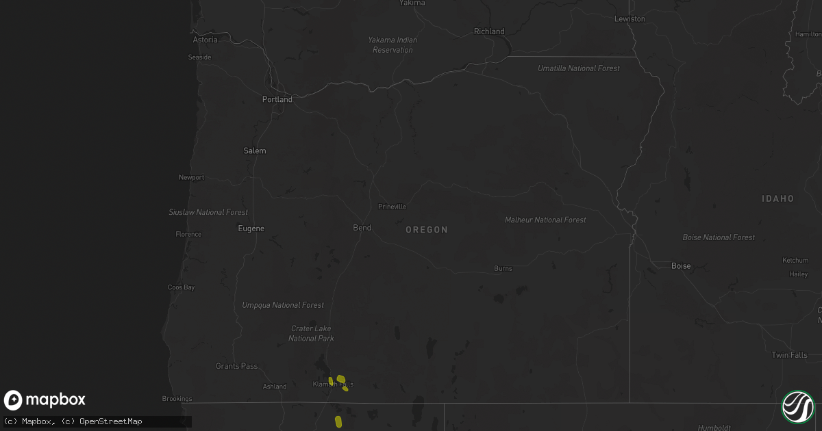
Hail Map in Oregon on August 5, 2020
Get this storm
August 5 map
$229
one time, instant access
Download today. No call, no setup
Keep the $229
Bought the map and want the full workflow? Apply the entire $229 to a subscription within 7 days. None of it is wasted.
Every map, not just this one
This buys you this map. Subscription and you get every map we run, in the markets you choose from a few cities to whole states to nationwide. Plus real-time alerts the moment a storm fires.
Contact data
Name, contact info, occupancy, even credit band for addresses in the footprint. You go from where it hit to who to call.
Become the source they trust
Unlimited branding weather history reports on demand. You already have the documented answer ready for the property owner, and you are the one who showed up with it.
Property data and RoofTrace estimates
Pull up any address you have got, its value and the exact code rules for that jurisdiction, straight from One Click Code. Then RoofTrace estimates the squares, pitch, and roof value, priced the way you price.
Storm reports in Oregon
Oregon
| Date | Description |
|---|---|
| 08/05/20201:59 AM CDT | At 658 PM PDT, a severe thunderstorm was located 7 miles south of Chemult, or 22 miles northeast of Crater Lake, moving north at 20 mph. HAZARD...Quarter size hail. SOURCE...Radar indicated. IMPACT...Damage to vehicles is expected. Locations impacted include... Chemult.This includes the following highways... US 97 in Oregon between mile markers 203 and 216. Highway 138 in Oregon between mile markers 97 and 100. |
| 08/05/20201:22 AM CDT | At 622 PM PDT, a severe thunderstorm was located near Klamath Marsh, or 17 miles east of Crater Lake, moving northwest at 10 mph. HAZARD...Quarter size hail. SOURCE...Radar indicated. IMPACT...Damage to vehicles is expected. This severe thunderstorm will remain over mainly rural areas of west central Klamath County.This includes US 97 in Oregon between mile markers 216 and 232. |
| 08/04/202011:42 PM CDT | At 441 PM PDT, a severe thunderstorm was located over Klamath Falls, and is nearly stationary. HAZARD...Quarter size hail. SOURCE...Radar indicated. IMPACT...Damage to vehicles is expected. Locations impacted include... Klamath Falls, Hagelstein County Park, Moore Park and Altamont. This includes the following highways... US 97 in Oregon between mile markers 261 and 276. Klamath-Lakeview Highway 140 in Oregon between mile markers 3 and 7. Highway 39 in Oregon near mile marker 1. |
| 08/04/202011:13 PM CDT | At 412 PM PDT, a severe thunderstorm was located 9 miles north of Olene, or 9 miles northeast of Klamath Falls, moving north at 20 mph. HAZARD...Quarter size hail. SOURCE...Radar indicated. IMPACT...Damage to vehicles is expected. This severe thunderstorm will remain over mainly rural areas of south central Klamath County.This includes Klamath-Lakeview Highway 140 in Oregon between milemarkers 14 and 18. |
| 08/04/202010:59 PM CDT | At 358 PM PDT, a severe thunderstorm was located near Olene, or 8 miles southeast of Klamath Falls, moving north at 10 mph. HAZARD...Quarter size hail. SOURCE...Radar indicated. IMPACT...Damage to vehicles is expected. Locations impacted include... Klamath Falls, Miller Island Klamath Wildlife Area, Midland and Altamont.This includes the following highways... US 97 in Oregon between mile markers 275 and 283. Klamath-Lakeview Highway 140 in Oregon between mile markers 3 and 8. Lake of the Woods Highway 140 in Oregon between mile markers 67 and68. Highway 66 in Oregon between mile markers 56 and 59. Highway 39 in Oregon between mile markers 1 and 13. |
| 08/04/202010:43 PM CDT | At 342 PM PDT, a severe thunderstorm was located near Olene, or 13 miles southeast of Klamath Falls, movingt north at 10 mph. HAZARD...Quarter size hail. SOURCE...Radar indicated. IMPACT...Damage to vehicles is expected. Locations impacted include... Olene and Dairy. This includes the following highways... Klamath-Lakeview Highway 140 in Oregon between mile markers 9 and 22. Highway 70 in Oregon between mile markers 1 and 3. |
| 08/04/20209:00 PM CDT | Tree limbs down. Damage to vehicle. Time estimated. Report via social media. |
| 08/04/20207:40 PM CDT | Picture showing quarter sized hail... With followup confirmation. |
| 08/04/20207:03 PM CDT | Picture of 1 inch hail taken next to a quarter to estimate the size. Person reported melting had been occurring before they could take the picture. |
All States Impacted by Hail Map on August 5, 2020
Cities Impacted by Hail Map on August 5, 2020
- Macdoel, CA
- Las Vegas, NM
- Montezuma, NM
- Raton, NM
- Dairy, OR
- Klamath Falls, OR
- Parker, CO
- Colorado Springs, CO
- Strasburg, CO
- Byers, CO
- Manitou Springs, CO
- Fountain, CO
- Boulder, CO
- Golden, CO
- Cascade, CO
- Wiggins, CO
- Fort Morgan, CO
- Weldona, CO
- Brush, CO
- Vernon, CO
- Yuma, CO
- Eckley, CO
- Otis, CO
- Wetmore, CO
- Pueblo, CO
- Beulah, CO
- Wray, CO
- Julesburg, CO
- Akron, CO
- Stratton, CO
- Burlington, CO
- Harrison, NE
- Broadwater, NE
- Lisco, NE
- Haigler, NE
- Saint Francis, KS
- Parks, NE
- Gurley, NE
- Sidney, NE
- Stratton, NE
- Atwood, KS
- McDonald, KS
- Oshkosh, NE
- Saronville, NE
- Sutton, NE
- Harvard, NE
- Hastings, NE
- Clay Center, NE
- Trumbull, NE
- Inland, NE
- Riverdale, NE
- Amherst, NE
- Pleasanton, NE
- Merriman, NE
- Eddyville, NE
- Cozad, NE
- Lexington, NE
- Sumner, NE
- Oconto, NE
- Friend, NE
- Dorchester, NE
- Gambrills, MD
- Odenton, MD
- Grovetown, GA
- Harlem, GA
- Appling, GA
- Glenrock, WY
- Wheatland, WY
- Lusk, WY
- Van Tassell, WY
- Chiloquin, OR
- Bosler, WY
- Angora, NE
- White Sulphur Springs, MT
- Ensign, KS
- Max, NE
- Whitney, NE
- Woodston, KS
- Massey, MD
- Galena, MD
- Millington, MD
- Stockett, MT
- Tuthill, SD
- Chemult, OR
- Hayes Center, NE
- Wellfleet, NE
- Alliance, NE
- Hemingford, NE
- Gordon, NE
- Rushville, NE
- Roggen, CO
- Crawford, NE
- Doniphan, NE
- Montague, CA
- Cheyenne, WY
- Valentine, NE
- Maxwell, NE
- North Platte, NE
- Wood River, NE
- Winona, KS
- Esbon, KS
- Downs, KS
- Gaylord, KS
- Portis, KS
- Gate, OK
- Marsland, NE
- Wolf Creek, MT
- Eustis, NE
- Shickley, NE
- Benkelman, NE
- Cody, NE
- Mason City, NE
- Woodland Park, CO
- Minneola, KS
- Pierce, NE
- Montezuma, KS
- Garden City, KS
- Midwest, WY
- Wadley, GA
- Bartow, GA
- Yreka, CA
- La Pine, OR
- Kilgore, NE
- Sisters, OR
- Etna, CA
- Gazelle, CA
- Arnold, NE
- Divide, CO
- Cawker City, KS
- Pierceville, KS
- Stokesdale, NC
- Summerfield, NC
- Claxton, GA
- Pilot Mountain, NC
- Carleton, NE
- Davenport, NE
- Colby, KS
- Levant, KS
- Deer Trail, CO
- Millersville, MD
- Fort George G Meade, MD
- Bowie, MD
- Hanahan, SC
- Goose Creek, SC
- Charleston, SC
- Sylvan Grove, KS
- Lucas, KS
- Lincoln, DE
- Greenwood, DE
- Harrington, DE
- Elberton, GA
- Brooklet, GA
- Norfolk, NE
- Dover, DE
- Clayton, DE
- Hay Springs, NE
- Chadron, NE
- Great Falls, MT
- Arvada, CO
- Ingalls, KS
- Holcomb, KS
- Venango, NE
- Dickens, NE
- Queen Anne, MD
- Ridgely, MD
- Germanton, NC
- Rural Hall, NC
- Alton, KS
- Osmond, NE
- Kirwin, KS
- Stockton, KS
- Mitchell, NE
- Giltner, NE
- Juniata, NE
- Edgar, NE
- Fowler, KS
- Pembroke, GA
- Plains, KS
- Chesapeake Beach, MD
- Prince Frederick, MD
- Huntingtown, MD
- Ainsworth, NE
- Wallace, KS
- Kennedyville, MD
- Crumpton, MD
- Chestertown, MD
- Stevensville, MD
- Cimarron, KS
- Bridgeville, DE
- Ellendale, DE
- Mcalister, NM
- Marydel, MD
- Henderson, MD
- Annapolis, MD
- Arnold, MD


