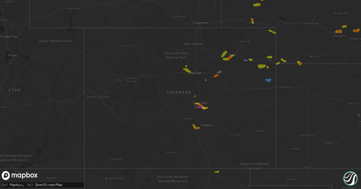
Hail Map in Colorado on August 5, 2020
Get this storm
August 5 map
$229
one time, instant access
Download today. No call, no setup
Keep the $229
Bought the map and want the full workflow? Apply the entire $229 to a subscription within 7 days. None of it is wasted.
Every map, not just this one
This buys you this map. Subscription and you get every map we run, in the markets you choose from a few cities to whole states to nationwide. Plus real-time alerts the moment a storm fires.
Contact data
Name, contact info, occupancy, even credit band for addresses in the footprint. You go from where it hit to who to call.
Become the source they trust
Unlimited branding weather history reports on demand. You already have the documented answer ready for the property owner, and you are the one who showed up with it.
Property data and RoofTrace estimates
Pull up any address you have got, its value and the exact code rules for that jurisdiction, straight from One Click Code. Then RoofTrace estimates the squares, pitch, and roof value, priced the way you price.
Storm reports in Colorado
Colorado
| Date | Description |
|---|---|
| 08/05/20206:48 PM CDT | Kako gust to 55kt. |
| 08/05/20206:44 PM CDT | A local report indicates 1.25 inch wind near 1 SSE SECURITY |
| 08/05/20206:29 PM CDT | A local report indicates 1.00 inch wind near 3 SE BRUSH |
| 08/05/20206:19 PM CDT | Delayed report of an 18 inch diameter tree uprooted near route 34 and road r. Several 5 to 6 inch diameter tree limbs also broken between fort morgan and brush. Time es |
| 08/05/20205:44 PM CDT | A local report indicates 1.50 inch wind near FOUNTAIN |
| 08/05/20205:41 PM CDT | A local report indicates 2.00 inch wind near 1 NW SECURITY |
| 08/05/20205:40 PM CDT | Report via spotternetwork. |
| 08/05/20205:37 PM CDT | Still falling at time of the report. Hail size estimated. |
| 08/05/20205:35 PM CDT | A local report indicates 1.00 inch wind near SECURITY |
| 08/05/20205:33 PM CDT | Reported at security and main colorado springs. |
| 08/05/20205:30 PM CDT | Time estimated by radar. |
| 08/05/20205:28 PM CDT | A local report indicates 2.00 inch wind near 4 S COLORADO SPRINGS |
| 08/05/20205:25 PM CDT | A local report indicates 2.00 inch wind near 4 S COLORADO SPRINGS |
| 08/05/20205:19 PM CDT | A local report indicates 1.75 inch wind near 4 S COLORADO SPRINGS |
| 08/05/20205:05 PM CDT | A local report indicates 1.75 inch wind near 4 S COLORADO SPRINGS |
| 08/05/20205:01 PM CDT | Reported at 10th and colorado ave... Colorado springs... Co. |
| 08/05/20205:00 PM CDT | *** 1 inj *** woman was hit in the wrist at 7 falls and was injured. Time estimated at 4 pm. |
| 08/05/20204:58 PM CDT | Ended 412 pm. |
| 08/05/20204:58 PM CDT | A local report indicates 1.00 inch wind near 2 WNW COLORADO SPRINGS |
| 08/05/20204:56 PM CDT | Station k1ow. Time estimated by radar. |
| 08/05/20204:55 PM CDT | A local report indicates 1.75 inch wind near 3 WSW COLORADO SPRINGS |
| 08/05/20204:54 PM CDT | A local report indicates 1.00 inch wind near 3 WSW COLORADO SPRINGS |
| 08/05/20204:52 PM CDT | A local report indicates 1.00 inch wind near 1 WNW COLORADO SPRINGS |
| 08/05/20204:52 PM CDT | A local report indicates 1.50 inch wind near 3 SE MANITOU SPRINGS |
| 08/05/20204:06 PM CDT | Also recorded a 46mph wind gust. Time estimated by radar. |
| 08/05/20203:16 AM CDT | At 816 PM MDT, severe thunderstorms were located along a line extending from 14 miles east of Bonny Reservoir to 7 miles northwest of Kanorado, moving southeast at 25 mph. HAZARD...60 mph wind gusts. SOURCE...Radar indicated. IMPACT...Expect damage to roofs, siding, and trees. Locations impacted include... Goodland, Kanorado, Ruleton and Edson. People attending Sherman County Fairgrounds should seek safe shelterimmediately!This includes Interstate 70 in Kansas between mile markers 0 and 35. |
| 08/05/20202:48 AM CDT | At 748 PM MDT, a severe thunderstorm was located 12 miles southwest of Bonny Reservoir, moving southeast at 35 mph. HAZARD...60 mph wind gusts and nickel size hail. SOURCE...Radar indicated. IMPACT...Expect damage to roofs, siding, and trees. Locations impacted include... Burlington and Bethune. This includes the following highways... Interstate 70 in Colorado between mile markers 426 and 450. Highway 385 between mile markers 181 and 206, and near mile marker211. |
| 08/05/20202:44 AM CDT | At 744 PM MDT, a severe thunderstorm was located near Cascade, or 8 miles west of Colorado Springs, moving east at 5 mph. HAZARD...Half dollar size hail. SOURCE...Radar indicated. IMPACT...Damage to vehicles is expected. Locations impacted include... Western Colorado Springs, Manitou Springs and Cascade. |
| 08/05/20202:43 AM CDT | At 743 PM MDT, a severe thunderstorm was located 9 miles southwest of Pueblo Reservoir, or 12 miles east of Junkins Burn Scar, moving east at 20 mph. HAZARD...Golf ball size hail and 60 mph wind gusts. SOURCE...Radar indicated. IMPACT...People and animals outdoors will be injured. Expect hail damage to roofs, siding, windows, and vehicles. Expect wind damage to roofs, siding, and trees. Locations impacted include... Southwestern Pueblo and Salt Creek. |
| 08/05/20202:20 AM CDT | At 720 PM MDT, a severe thunderstorm was located 7 miles northeast of Junkins Burn Scar, moving southeast at 30 mph. HAZARD...60 mph wind gusts and quarter size hail. SOURCE...Radar indicated. IMPACT...Hail damage to vehicles is expected. Expect wind damage to roofs, siding, and trees. Locations impacted include... Northeastern Junkins Burn Scar, Beulah, Wetmore and Colorado City. |
| 08/05/20202:13 AM CDT | At 713 PM MDT, a severe thunderstorm was located over Pikes Peak, or 11 miles west of Colorado Springs, moving east at 5 mph. HAZARD...Quarter size hail. SOURCE...Radar indicated. IMPACT...Damage to vehicles is expected. Locations impacted include... Manitou Springs, Pikes Peak, Cascade and Chipita Park. |
| 08/05/20201:17 AM CDT | At 617 PM MDT, a severe thunderstorm was located 11 miles east of Sugarite, or 14 miles east of Raton, moving northeast at 35 mph. HAZARD...60 mph wind gusts and quarter size hail. SOURCE...Radar indicated. IMPACT...Hail damage to vehicles is expected. Expect wind damage to roofs, siding, and trees. This severe thunderstorm will remain over mainly rural areas of northwestern Union and northeastern Colfax Counties. |
| 08/05/20201:06 AM CDT | At 606 PM MDT, a severe thunderstorm was located near Schriever AFB, or 14 miles southeast of Colorado Springs, moving east at 10 mph. HAZARD...Ping pong ball size hail. SOURCE...Trained weather spotters. IMPACT...People and animals outdoors will be injured. Expect damage to roofs, siding, windows, and vehicles. This severe thunderstorm will remain over mainly rural areas of central El Paso County. |
| 08/05/202012:58 AM CDT | At 557 PM MDT, a severe thunderstorm was located 4 miles southwest of Platner, or 6 miles southeast of Akron, moving east at 25 mph. HAZARD...60 mph wind gusts and quarter size hail. SOURCE...Radar indicated. IMPACT...Expect damage to roofs, siding, and trees. Hail damage to vehicles is expected. Locations impacted include... Akron, Otis, Lone Star, Platner and Burdett. |
| 08/05/202012:45 AM CDT | At 545 PM MDT, a severe thunderstorm was located 16 miles south of Yuma, moving north at 10 mph. HAZARD...60 mph wind gusts and quarter size hail. SOURCE...Radar indicated. IMPACT...Hail damage to vehicles is expected. Expect wind damage to roofs, siding, and trees. Locations impacted include... Yuma, Eckley, Abarr and Heartstrong. People attending Yuma County Fairgrounds should seek safe shelterimmediately! |
| 08/05/202012:41 AM CDT | At 540 PM MDT, a severe thunderstorm was located over Security-Widefield, or 8 miles southeast of Colorado Springs, moving east at 10 mph. HAZARD...Half dollar size hail. SOURCE...Radar indicated. IMPACT...Damage to vehicles is expected. Locations impacted include... Southeastern Colorado Springs, Fountain, Security, Security-Widefield and Fort Carson. |
| 08/05/202012:30 AM CDT | At 529 PM MDT, a severe thunderstorm was located 4 miles east of Brush, or 12 miles east of Fort Morgan, moving northeast at 30 mph. HAZARD...60 mph wind gusts and quarter size hail. SOURCE...Radar indicated. IMPACT...Expect damage to roofs, siding, and trees. Hail damage to vehicles is expected. Locations impacted include... Akron, Brush, Hillrose, Snyder, Midway and Prewitt Reservoir. |
| 08/04/202011:54 PM CDT | At 453 PM MDT, a severe thunderstorm was located near Security-Widefield, or 11 miles southeast of Colorado Springs, moving east at 10 mph. HAZARD...Two inch hail and 60 mph wind gusts. SOURCE...Trained weather spotters. IMPACT...People and animals outdoors will be injured. Expect hail damage to roofs, siding, windows, and vehicles. Expect wind damage to roofs, siding, and trees. This severe thunderstorm will be near... Hanover around 540 PM MDT. |
| 08/04/202011:46 PM CDT | At 445 PM MDT, a severe thunderstorm was located over western Colorado Springs, moving east at 40 mph. HAZARD...60 mph wind gusts and half dollar size hail. SOURCE...Radar indicated. IMPACT...Hail damage to vehicles is expected. Expect wind damage to roofs, siding, and trees. Locations impacted include... Colorado Springs, Manitou Springs, Schriever AFB, Peterson AFB, Falcon, Cimarron Hills, Cascade and Chipita Park. |
| 08/04/202011:45 PM CDT | At 444 PM MDT, a severe thunderstorm was located near Log Lane Village, or 5 miles west of Fort Morgan, moving northeast at 35 mph. HAZARD...60 mph wind gusts and quarter size hail. SOURCE...Radar indicated. IMPACT...Expect damage to roofs, siding, and trees. Hail damage to vehicles is expected. Locations impacted include... Fort Morgan, Brush, Wiggins, Log Lane Village, Hillrose, Gary, Hoyt, Antelope Springs, Weldona, Twelve-Mile Corner, Jackson Reservoir, Adena School, Orchard, Adena, Snyder and Goodrich. |
| 08/04/202011:30 PM CDT | At 430 PM MDT, a severe thunderstorm was located 7 miles northeast of Stoneham, or 22 miles west of Sterling, moving east at 40 mph. HAZARD...60 mph wind gusts and quarter size hail. SOURCE...Radar indicated. IMPACT...Expect damage to roofs, siding, and trees. Hail damage to vehicles is expected. Locations impacted include... Sterling, Merino, Iliff, Proctor, Padroni, Westplains, Atwood, Logan Corners, North Sterling Reservoir, Pawnee Pass and Willard. |
| 08/04/202011:08 PM CDT | At 408 PM MDT, a severe thunderstorm was located over southwestern Colorado Springs, moving southeast at 15 mph. HAZARD...Golf ball size hail and 60 mph wind gusts. SOURCE...Trained weather spotters. IMPACT...People and animals outdoors will be injured. Expect hail damage to roofs, siding, windows, and vehicles. Expect wind damage to roofs, siding, and trees. This severe thunderstorm will be near... Fort Carson and Stratmoor around 415 PM MDT. Security around 425 PM MDT. Security-Widefield around 435 PM MDT. Fountain around 445 PM MDT. |
| 08/04/202011:03 PM CDT | At 402 PM MDT, a severe thunderstorm was located 4 miles east of Pinecliffe, or 25 miles northwest of Denver, moving southeast at 5 mph. HAZARD...60 mph wind gusts and quarter size hail. SOURCE...Radar indicated. IMPACT...Expect damage to roofs, siding, and trees. Hail damage to vehicles is expected. Locations impacted include... Western Arvada, western Westminster, southern Boulder, southwestern Broomfield, Lafayette, Louisville, Superior, Crisman, Rocky Flats, Eldorado Springs, White Ranch Open Space and Pinecliffe. |
| 08/04/202010:48 PM CDT | At 348 PM MDT, a severe thunderstorm was located over Manitou Springs, or near Colorado Springs, moving southeast at 15 mph. HAZARD...60 mph wind gusts and half dollar size hail. SOURCE...Radar indicated. IMPACT...Hail damage to vehicles is expected. Expect wind damage to roofs, siding, and trees. Locations impacted include... Southern Colorado Springs, Manitou Springs, Stratmoor, Fort Carson, Peterson AFB, Cimarron Hills and Security-Widefield. |
| 08/04/202010:32 PM CDT | At 331 PM MDT, a severe thunderstorm was located 7 miles northeast of Byers, or 37 miles southwest of Fort Morgan, moving northeast at 25 mph. HAZARD...60 mph wind gusts and half dollar size hail. SOURCE...Radar indicated. Spotter have reported hail up to golf ball sized hail with this storm. IMPACT...Expect damage to roofs, siding, and trees. Hail damage to vehicles is expected. Locations impacted include... Leader and Shamrock. |
| 08/04/20209:47 PM CDT | At 246 PM MDT, a severe thunderstorm was located near Palmer Lake, or 20 miles northwest of Colorado Springs, moving east at 10 mph. HAZARD...60 mph wind gusts and half dollar size hail. SOURCE...Radar indicated. IMPACT...Hail damage to vehicles is expected. Expect wind damage to roofs, siding, and trees. Locations impacted include... Northern Colorado Springs, Monument, Air Force Academy, Palmer Lake and Gleneagle. |
| 08/04/20209:43 PM CDT | At 243 PM MDT, a severe thunderstorm was located 7 miles south of Bennett, or 26 miles east of Denver, moving northeast at 15 mph. HAZARD...60 mph wind gusts and quarter size hail. SOURCE...Radar indicated. IMPACT...Expect damage to roofs, siding, and trees. Hail damage to vehicles is expected. Locations impacted include... Northeastern Aurora, Bennett, Deer Trail, Strasburg, Byers and Manila Village. |
| 08/04/20209:10 PM CDT | At 210 PM MDT, a severe thunderstorm was located 7 miles southeast of Arapahoe Park, or 22 miles southeast of Denver, moving northeast at 15 mph. HAZARD...60 mph wind gusts and half dollar size hail. SOURCE...Radar indicated. IMPACT...Expect damage to roofs, siding, and trees. Hail damage to vehicles is expected. This severe thunderstorm will remain over mainly rural areas of northwestern Elbert and south central Arapahoe Counties. |
| 08/04/20208:30 PM CDT | A local report indicates 1.00 inch wind near 7 NNE BEULAH |
| 08/04/20208:15 PM CDT | Awos station k2v5 2 nw wray. |
| 08/04/20207:25 PM CDT | Delayed report. Otis telegraph reported a large tree uprooted in otis. Time estimated by radar. |
| 08/04/20207:24 PM CDT | A local report indicates 60 MPH wind near 6 NNW YUMA |
| 08/04/20207:15 PM CDT | Reported via social media with pictures. |
| 08/04/20207:00 PM CDT | A local report indicates 60 MPH wind near 3 NE HEARTSTRONG |
All States Impacted by Hail Map on August 5, 2020
Cities Impacted by Hail Map on August 5, 2020
- Macdoel, CA
- Las Vegas, NM
- Montezuma, NM
- Raton, NM
- Dairy, OR
- Klamath Falls, OR
- Parker, CO
- Colorado Springs, CO
- Strasburg, CO
- Byers, CO
- Manitou Springs, CO
- Fountain, CO
- Boulder, CO
- Golden, CO
- Cascade, CO
- Wiggins, CO
- Fort Morgan, CO
- Weldona, CO
- Brush, CO
- Vernon, CO
- Yuma, CO
- Eckley, CO
- Otis, CO
- Wetmore, CO
- Pueblo, CO
- Beulah, CO
- Wray, CO
- Julesburg, CO
- Akron, CO
- Stratton, CO
- Burlington, CO
- Harrison, NE
- Broadwater, NE
- Lisco, NE
- Haigler, NE
- Saint Francis, KS
- Parks, NE
- Gurley, NE
- Sidney, NE
- Stratton, NE
- Atwood, KS
- McDonald, KS
- Oshkosh, NE
- Saronville, NE
- Sutton, NE
- Harvard, NE
- Hastings, NE
- Clay Center, NE
- Trumbull, NE
- Inland, NE
- Riverdale, NE
- Amherst, NE
- Pleasanton, NE
- Merriman, NE
- Eddyville, NE
- Cozad, NE
- Lexington, NE
- Sumner, NE
- Oconto, NE
- Friend, NE
- Dorchester, NE
- Gambrills, MD
- Odenton, MD
- Grovetown, GA
- Harlem, GA
- Appling, GA
- Glenrock, WY
- Wheatland, WY
- Lusk, WY
- Van Tassell, WY
- Chiloquin, OR
- Bosler, WY
- Angora, NE
- White Sulphur Springs, MT
- Ensign, KS
- Max, NE
- Whitney, NE
- Woodston, KS
- Massey, MD
- Galena, MD
- Millington, MD
- Stockett, MT
- Tuthill, SD
- Chemult, OR
- Hayes Center, NE
- Wellfleet, NE
- Alliance, NE
- Hemingford, NE
- Gordon, NE
- Rushville, NE
- Roggen, CO
- Crawford, NE
- Doniphan, NE
- Montague, CA
- Cheyenne, WY
- Valentine, NE
- Maxwell, NE
- North Platte, NE
- Wood River, NE
- Winona, KS
- Esbon, KS
- Downs, KS
- Gaylord, KS
- Portis, KS
- Gate, OK
- Marsland, NE
- Wolf Creek, MT
- Eustis, NE
- Shickley, NE
- Benkelman, NE
- Cody, NE
- Mason City, NE
- Woodland Park, CO
- Minneola, KS
- Pierce, NE
- Montezuma, KS
- Garden City, KS
- Midwest, WY
- Wadley, GA
- Bartow, GA
- Yreka, CA
- La Pine, OR
- Kilgore, NE
- Sisters, OR
- Etna, CA
- Gazelle, CA
- Arnold, NE
- Divide, CO
- Cawker City, KS
- Pierceville, KS
- Stokesdale, NC
- Summerfield, NC
- Claxton, GA
- Pilot Mountain, NC
- Carleton, NE
- Davenport, NE
- Colby, KS
- Levant, KS
- Deer Trail, CO
- Millersville, MD
- Fort George G Meade, MD
- Bowie, MD
- Hanahan, SC
- Goose Creek, SC
- Charleston, SC
- Sylvan Grove, KS
- Lucas, KS
- Lincoln, DE
- Greenwood, DE
- Harrington, DE
- Elberton, GA
- Brooklet, GA
- Norfolk, NE
- Dover, DE
- Clayton, DE
- Hay Springs, NE
- Chadron, NE
- Great Falls, MT
- Arvada, CO
- Ingalls, KS
- Holcomb, KS
- Venango, NE
- Dickens, NE
- Queen Anne, MD
- Ridgely, MD
- Germanton, NC
- Rural Hall, NC
- Alton, KS
- Osmond, NE
- Kirwin, KS
- Stockton, KS
- Mitchell, NE
- Giltner, NE
- Juniata, NE
- Edgar, NE
- Fowler, KS
- Pembroke, GA
- Plains, KS
- Chesapeake Beach, MD
- Prince Frederick, MD
- Huntingtown, MD
- Ainsworth, NE
- Wallace, KS
- Kennedyville, MD
- Crumpton, MD
- Chestertown, MD
- Stevensville, MD
- Cimarron, KS
- Bridgeville, DE
- Ellendale, DE
- Mcalister, NM
- Marydel, MD
- Henderson, MD
- Annapolis, MD
- Arnold, MD


