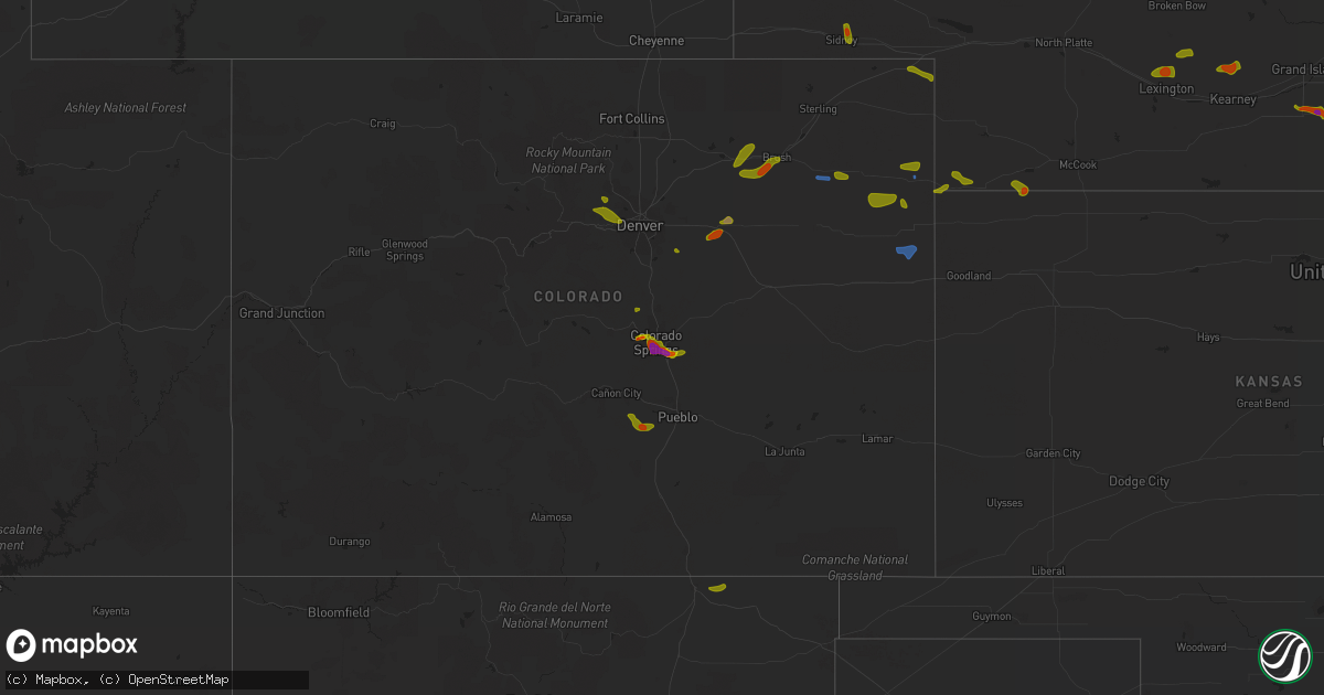
Hail Map on August 5, 2020
Get this storm
August 5 map
$229
one time, instant access
Download today. No call, no setup
Keep the $229
Bought the map and want the full workflow? Apply the entire $229 to a subscription within 7 days. None of it is wasted.
Every map, not just this one
This buys you this map. Subscription and you get every map we run, in the markets you choose from a few cities to whole states to nationwide. Plus real-time alerts the moment a storm fires.
Contact data
Name, contact info, occupancy, even credit band for addresses in the footprint. You go from where it hit to who to call.
Become the source they trust
Unlimited branding weather history reports on demand. You already have the documented answer ready for the property owner, and you are the one who showed up with it.
Property data and RoofTrace estimates
Pull up any address you have got, its value and the exact code rules for that jurisdiction, straight from One Click Code. Then RoofTrace estimates the squares, pitch, and roof value, priced the way you price.
States Impacted by Hail Map on August 5, 2020
Storm reports
Georgia
| Date | Description |
|---|---|
| 08/05/20205:02 PM CDT | An 18 wheel semi-truck was blown over off the road onto its side. A large number of pine trees were snapped about halfway up the trunk. Based on these reports the downb |
| 08/05/20205:02 PM CDT | Trees across power lines at louisville road and carole drive. Time estimated from radar. |
| 08/05/20205:02 PM CDT | Multiple trees down on the road with multiple accidents reported. Time estimated by radar. |
| 08/05/20205:02 PM CDT | Trees down on power lines on louisville road southeast of appling. Time estimated from radar. |
| 08/05/20204:49 PM CDT | Mcduffie county dispatch reported a tree down on powerlines on ginger hill rd. Time estimated by radar. |
| 08/05/20203:30 PM CDT | Approx half a dozen trees reported down in sw butts county... Just east of i-75. Several of the trees were large oaks downed across roadways. |
| 08/05/20204:20 AM CDT | At 920 PM EDT, a severe thunderstorm was located over Moxley, or near Louisville, moving northeast at 15 mph. HAZARD...60 mph wind gusts and quarter size hail. SOURCE...Radar indicated. IMPACT...Hail damage to vehicles is expected. Expect wind damage to roofs, siding, and trees. Locations impacted include... Louisville, Wadley, Bartow and Moxley. |
Virginia
| Date | Description |
|---|---|
| 08/05/20205:05 PM CDT | Tree down on harman circle. Time estimated from radar. |
| 08/05/20204:57 PM CDT | Tree down in 700 block of silver lake rd. |
| 08/05/20204:56 PM CDT | Tree down on riner rd and smith creek rd. |
| 08/05/20203:56 AM CDT | At 856 PM EDT, a severe thunderstorm was located near Madison, moving southeast at 10 mph. HAZARD...60 mph wind gusts. SOURCE...Radar indicated. IMPACT...Damaging winds will cause some trees and large branches to fall. This could injure those outdoors, as well as damage homes and vehicles. Roadways may become blocked by downed trees. Localized power outages are possible. Unsecured light objects may become projectiles. Locations impacted include... Madison, Brightwood, Aroda, Banco, Madison Mills, Fordsville, Oakpark, Haywood, Twymans Mill, Leon, Pratts and Locust Dale. |
| 08/05/20203:40 AM CDT | Tree down on paul spring rd. Near fort hunt rd. |
| 08/05/20203:14 AM CDT | At 814 PM EDT, a severe thunderstorm was located near Madison, moving east at 15 mph. HAZARD...60 mph wind gusts. SOURCE...Radar indicated. IMPACT...Damaging winds will cause some trees and large branches to fall. This could injure those outdoors, as well as damage homes and vehicles. Roadways may become blocked by downed trees. Localized power outages are possible. Unsecured light objects may become projectiles. Locations impacted include... Madison, Brightwood, Criglersville, Slate Mills, Etlan, Nethers, Oakpark, Haywood, Syria, Banco, Reva, Graves Mill, Aylor and Leon. |
| 08/05/20201:02 AM CDT | At 601 PM EDT, a severe thunderstorm was located near Childress, or near Christiansburg, moving northeast at 15 mph. HAZARD...60 mph wind gusts. SOURCE...Radar indicated. IMPACT...Expect damage to roofs, siding, and trees. Locations impacted include... Blacksburg... Christiansburg... Shawsville... and Merrimac.This includes The following Location Virginia Tech. |
Nebraska
| Date | Description |
|---|---|
| 08/05/20205:00 AM CDT | Delayed report. |
| 08/05/20204:03 AM CDT | At 903 PM CDT, severe thunderstorms were located along a line extending from 9 miles south of Stratton to 5 miles northwest of Atwood, moving northeast at 15 mph. HAZARD...60 mph wind gusts and half dollar size hail. SOURCE...Radar indicated. IMPACT...Hail damage to vehicles is expected. Expect wind damage to roofs, siding, and trees. Locations impacted include... Atwood, Trenton, Culbertson, Palisade, Stratton, Herndon and Ludell. |
| 08/05/20203:46 AM CDT | At 846 PM MDT, a severe thunderstorm was located 8 miles north of Sixteen-Mile Corner, or 8 miles southeast of Julesburg, moving southeast at 25 mph. HAZARD...60 mph wind gusts and quarter size hail. SOURCE...Radar indicated. IMPACT...Expect damage to roofs, siding, and trees. Hail damage to vehicles is expected. Locations impacted include... Julesburg. |
| 08/05/20203:41 AM CDT | At 840 PM MDT, a severe thunderstorm was located 7 miles west of Crescent Lake National Wildlife Refuge, or 26 miles northwest of Oshkosh, moving southeast at 10 mph. HAZARD...Ping pong ball size hail and 60 mph wind gusts. SOURCE...Radar indicated. IMPACT...People and animals outdoors will be injured. Expect hail damage to roofs, siding, windows, and vehicles. Expect wind damage to roofs, siding, and trees. Locations impacted include... Crescent Lake National Wildlife Refuge, Richardson Lake and Mumper. |
| 08/05/20203:30 AM CDT | At 830 PM MDT, a severe thunderstorm was located 11 miles west of Harrison, or 18 miles east of Lusk, moving southeast at 25 mph. HAZARD...Golf ball size hail and 60 mph wind gusts. SOURCE...Radar indicated. IMPACT...People and animals outdoors will be injured. Expect hail damage to roofs, siding, windows, and vehicles. Expect wind damage to roofs, siding, and trees. This severe thunderstorm will be near... Harrison around 855 PM MDT.Other locations impacted by this severe thunderstorm include VanTassell. |
| 08/05/20202:52 AM CDT | At 751 PM MDT, a severe thunderstorm was located near Colton, or near Sidney, moving south at 10 mph. HAZARD...Golf ball size hail and 60 mph wind gusts. SOURCE...Radar indicated. IMPACT...People and animals outdoors will be injured. Expect hail damage to roofs, siding, windows, and vehicles. Expect wind damage to roofs, siding, and trees. This severe thunderstorm will be near... Sidney around 805 PM MDT. Colton around 810 PM MDT. Sunol around 815 PM MDT.This includes Interstate 80 in Nebraska between mile markers 60 and71. |
| 08/05/20201:59 AM CDT | Deputy sheriff reports golf ball size hail in inland. |
| 08/05/20201:32 AM CDT | A local report indicates 1.00 inch wind near 2 N HASTINGS |
| 08/05/20201:27 AM CDT | Delayed report via social media with photo. Time estimated from radar. |
| 08/05/20201:25 AM CDT | At 625 PM MDT, a severe thunderstorm was located near Highland Center, or 12 miles west of Holyoke, moving east at 25 mph. HAZARD...60 mph wind gusts and quarter size hail. SOURCE...Radar indicated. IMPACT...Expect damage to roofs, siding, and trees. Hail damage to vehicles is expected. Locations impacted include... Holyoke, Haxtun, Paoli, Highland Center and Pleasant Valley. |
| 08/05/20201:13 AM CDT | At 613 PM MDT, a severe thunderstorm was located 10 miles northwest of Lisco, or 23 miles northwest of Oshkosh, moving east at 20 mph. HAZARD...60 mph wind gusts and quarter size hail. SOURCE...Radar indicated. IMPACT...Hail damage to vehicles is expected. Expect wind damage to roofs, siding, and trees. This severe thunderstorm will remain over mainly rural areas of east central Morrill County. |
| 08/04/202011:32 PM CDT | At 432 PM MDT, a severe thunderstorm was located near Agate Bed National Monument, or 25 miles northeast of Torrington, moving east at 10 mph. HAZARD...Ping pong ball size hail and 60 mph wind gusts. SOURCE...Radar indicated. IMPACT...People and animals outdoors will be injured. Expect hail damage to roofs, siding, windows, and vehicles. Expect wind damage to roofs, siding, and trees. This severe thunderstorm will be near... Agate Bed National Monument around 440 PM MDT. |
| 08/04/202011:05 PM CDT | Via social media |
| 08/04/20209:00 PM CDT | Time estimated by radar. |
| 08/04/20208:15 PM CDT | Trained spotter reported quarter to half dollar size hail. |
| 08/04/20207:25 PM CDT | Corrects previous hail report from 9 ene broadwater. |
Colorado
| Date | Description |
|---|---|
| 08/05/20206:48 PM CDT | Kako gust to 55kt. |
| 08/05/20206:44 PM CDT | A local report indicates 1.25 inch wind near 1 SSE SECURITY |
| 08/05/20206:29 PM CDT | A local report indicates 1.00 inch wind near 3 SE BRUSH |
| 08/05/20206:19 PM CDT | Delayed report of an 18 inch diameter tree uprooted near route 34 and road r. Several 5 to 6 inch diameter tree limbs also broken between fort morgan and brush. Time es |
| 08/05/20205:44 PM CDT | A local report indicates 1.50 inch wind near FOUNTAIN |
| 08/05/20205:41 PM CDT | A local report indicates 2.00 inch wind near 1 NW SECURITY |
| 08/05/20205:40 PM CDT | Report via spotternetwork. |
| 08/05/20205:37 PM CDT | Still falling at time of the report. Hail size estimated. |
| 08/05/20205:35 PM CDT | A local report indicates 1.00 inch wind near SECURITY |
| 08/05/20205:33 PM CDT | Reported at security and main colorado springs. |
| 08/05/20205:30 PM CDT | Time estimated by radar. |
| 08/05/20205:28 PM CDT | A local report indicates 2.00 inch wind near 4 S COLORADO SPRINGS |
| 08/05/20205:25 PM CDT | A local report indicates 2.00 inch wind near 4 S COLORADO SPRINGS |
| 08/05/20205:19 PM CDT | A local report indicates 1.75 inch wind near 4 S COLORADO SPRINGS |
| 08/05/20205:05 PM CDT | A local report indicates 1.75 inch wind near 4 S COLORADO SPRINGS |
| 08/05/20205:01 PM CDT | Reported at 10th and colorado ave... Colorado springs... Co. |
| 08/05/20205:00 PM CDT | *** 1 inj *** woman was hit in the wrist at 7 falls and was injured. Time estimated at 4 pm. |
| 08/05/20204:58 PM CDT | A local report indicates 1.00 inch wind near 2 WNW COLORADO SPRINGS |
| 08/05/20204:58 PM CDT | Ended 412 pm. |
| 08/05/20204:56 PM CDT | Station k1ow. Time estimated by radar. |
| 08/05/20204:55 PM CDT | A local report indicates 1.75 inch wind near 3 WSW COLORADO SPRINGS |
| 08/05/20204:54 PM CDT | A local report indicates 1.00 inch wind near 3 WSW COLORADO SPRINGS |
| 08/05/20204:52 PM CDT | A local report indicates 1.00 inch wind near 1 WNW COLORADO SPRINGS |
| 08/05/20204:52 PM CDT | A local report indicates 1.50 inch wind near 3 SE MANITOU SPRINGS |
| 08/05/20204:06 PM CDT | Also recorded a 46mph wind gust. Time estimated by radar. |
| 08/05/20203:16 AM CDT | At 816 PM MDT, severe thunderstorms were located along a line extending from 14 miles east of Bonny Reservoir to 7 miles northwest of Kanorado, moving southeast at 25 mph. HAZARD...60 mph wind gusts. SOURCE...Radar indicated. IMPACT...Expect damage to roofs, siding, and trees. Locations impacted include... Goodland, Kanorado, Ruleton and Edson. People attending Sherman County Fairgrounds should seek safe shelterimmediately!This includes Interstate 70 in Kansas between mile markers 0 and 35. |
| 08/05/20202:48 AM CDT | At 748 PM MDT, a severe thunderstorm was located 12 miles southwest of Bonny Reservoir, moving southeast at 35 mph. HAZARD...60 mph wind gusts and nickel size hail. SOURCE...Radar indicated. IMPACT...Expect damage to roofs, siding, and trees. Locations impacted include... Burlington and Bethune. This includes the following highways... Interstate 70 in Colorado between mile markers 426 and 450. Highway 385 between mile markers 181 and 206, and near mile marker211. |
| 08/05/20202:44 AM CDT | At 744 PM MDT, a severe thunderstorm was located near Cascade, or 8 miles west of Colorado Springs, moving east at 5 mph. HAZARD...Half dollar size hail. SOURCE...Radar indicated. IMPACT...Damage to vehicles is expected. Locations impacted include... Western Colorado Springs, Manitou Springs and Cascade. |
| 08/05/20202:43 AM CDT | At 743 PM MDT, a severe thunderstorm was located 9 miles southwest of Pueblo Reservoir, or 12 miles east of Junkins Burn Scar, moving east at 20 mph. HAZARD...Golf ball size hail and 60 mph wind gusts. SOURCE...Radar indicated. IMPACT...People and animals outdoors will be injured. Expect hail damage to roofs, siding, windows, and vehicles. Expect wind damage to roofs, siding, and trees. Locations impacted include... Southwestern Pueblo and Salt Creek. |
| 08/05/20202:20 AM CDT | At 720 PM MDT, a severe thunderstorm was located 7 miles northeast of Junkins Burn Scar, moving southeast at 30 mph. HAZARD...60 mph wind gusts and quarter size hail. SOURCE...Radar indicated. IMPACT...Hail damage to vehicles is expected. Expect wind damage to roofs, siding, and trees. Locations impacted include... Northeastern Junkins Burn Scar, Beulah, Wetmore and Colorado City. |
| 08/05/20202:13 AM CDT | At 713 PM MDT, a severe thunderstorm was located over Pikes Peak, or 11 miles west of Colorado Springs, moving east at 5 mph. HAZARD...Quarter size hail. SOURCE...Radar indicated. IMPACT...Damage to vehicles is expected. Locations impacted include... Manitou Springs, Pikes Peak, Cascade and Chipita Park. |
| 08/05/20201:17 AM CDT | At 617 PM MDT, a severe thunderstorm was located 11 miles east of Sugarite, or 14 miles east of Raton, moving northeast at 35 mph. HAZARD...60 mph wind gusts and quarter size hail. SOURCE...Radar indicated. IMPACT...Hail damage to vehicles is expected. Expect wind damage to roofs, siding, and trees. This severe thunderstorm will remain over mainly rural areas of northwestern Union and northeastern Colfax Counties. |
| 08/05/20201:06 AM CDT | At 606 PM MDT, a severe thunderstorm was located near Schriever AFB, or 14 miles southeast of Colorado Springs, moving east at 10 mph. HAZARD...Ping pong ball size hail. SOURCE...Trained weather spotters. IMPACT...People and animals outdoors will be injured. Expect damage to roofs, siding, windows, and vehicles. This severe thunderstorm will remain over mainly rural areas of central El Paso County. |
| 08/05/202012:58 AM CDT | At 557 PM MDT, a severe thunderstorm was located 4 miles southwest of Platner, or 6 miles southeast of Akron, moving east at 25 mph. HAZARD...60 mph wind gusts and quarter size hail. SOURCE...Radar indicated. IMPACT...Expect damage to roofs, siding, and trees. Hail damage to vehicles is expected. Locations impacted include... Akron, Otis, Lone Star, Platner and Burdett. |
| 08/05/202012:45 AM CDT | At 545 PM MDT, a severe thunderstorm was located 16 miles south of Yuma, moving north at 10 mph. HAZARD...60 mph wind gusts and quarter size hail. SOURCE...Radar indicated. IMPACT...Hail damage to vehicles is expected. Expect wind damage to roofs, siding, and trees. Locations impacted include... Yuma, Eckley, Abarr and Heartstrong. People attending Yuma County Fairgrounds should seek safe shelterimmediately! |
| 08/05/202012:41 AM CDT | At 540 PM MDT, a severe thunderstorm was located over Security-Widefield, or 8 miles southeast of Colorado Springs, moving east at 10 mph. HAZARD...Half dollar size hail. SOURCE...Radar indicated. IMPACT...Damage to vehicles is expected. Locations impacted include... Southeastern Colorado Springs, Fountain, Security, Security-Widefield and Fort Carson. |
| 08/05/202012:30 AM CDT | At 529 PM MDT, a severe thunderstorm was located 4 miles east of Brush, or 12 miles east of Fort Morgan, moving northeast at 30 mph. HAZARD...60 mph wind gusts and quarter size hail. SOURCE...Radar indicated. IMPACT...Expect damage to roofs, siding, and trees. Hail damage to vehicles is expected. Locations impacted include... Akron, Brush, Hillrose, Snyder, Midway and Prewitt Reservoir. |
| 08/04/202011:54 PM CDT | At 453 PM MDT, a severe thunderstorm was located near Security-Widefield, or 11 miles southeast of Colorado Springs, moving east at 10 mph. HAZARD...Two inch hail and 60 mph wind gusts. SOURCE...Trained weather spotters. IMPACT...People and animals outdoors will be injured. Expect hail damage to roofs, siding, windows, and vehicles. Expect wind damage to roofs, siding, and trees. This severe thunderstorm will be near... Hanover around 540 PM MDT. |
| 08/04/202011:46 PM CDT | At 445 PM MDT, a severe thunderstorm was located over western Colorado Springs, moving east at 40 mph. HAZARD...60 mph wind gusts and half dollar size hail. SOURCE...Radar indicated. IMPACT...Hail damage to vehicles is expected. Expect wind damage to roofs, siding, and trees. Locations impacted include... Colorado Springs, Manitou Springs, Schriever AFB, Peterson AFB, Falcon, Cimarron Hills, Cascade and Chipita Park. |
| 08/04/202011:45 PM CDT | At 444 PM MDT, a severe thunderstorm was located near Log Lane Village, or 5 miles west of Fort Morgan, moving northeast at 35 mph. HAZARD...60 mph wind gusts and quarter size hail. SOURCE...Radar indicated. IMPACT...Expect damage to roofs, siding, and trees. Hail damage to vehicles is expected. Locations impacted include... Fort Morgan, Brush, Wiggins, Log Lane Village, Hillrose, Gary, Hoyt, Antelope Springs, Weldona, Twelve-Mile Corner, Jackson Reservoir, Adena School, Orchard, Adena, Snyder and Goodrich. |
| 08/04/202011:30 PM CDT | At 430 PM MDT, a severe thunderstorm was located 7 miles northeast of Stoneham, or 22 miles west of Sterling, moving east at 40 mph. HAZARD...60 mph wind gusts and quarter size hail. SOURCE...Radar indicated. IMPACT...Expect damage to roofs, siding, and trees. Hail damage to vehicles is expected. Locations impacted include... Sterling, Merino, Iliff, Proctor, Padroni, Westplains, Atwood, Logan Corners, North Sterling Reservoir, Pawnee Pass and Willard. |
| 08/04/202011:08 PM CDT | At 408 PM MDT, a severe thunderstorm was located over southwestern Colorado Springs, moving southeast at 15 mph. HAZARD...Golf ball size hail and 60 mph wind gusts. SOURCE...Trained weather spotters. IMPACT...People and animals outdoors will be injured. Expect hail damage to roofs, siding, windows, and vehicles. Expect wind damage to roofs, siding, and trees. This severe thunderstorm will be near... Fort Carson and Stratmoor around 415 PM MDT. Security around 425 PM MDT. Security-Widefield around 435 PM MDT. Fountain around 445 PM MDT. |
| 08/04/202011:03 PM CDT | At 402 PM MDT, a severe thunderstorm was located 4 miles east of Pinecliffe, or 25 miles northwest of Denver, moving southeast at 5 mph. HAZARD...60 mph wind gusts and quarter size hail. SOURCE...Radar indicated. IMPACT...Expect damage to roofs, siding, and trees. Hail damage to vehicles is expected. Locations impacted include... Western Arvada, western Westminster, southern Boulder, southwestern Broomfield, Lafayette, Louisville, Superior, Crisman, Rocky Flats, Eldorado Springs, White Ranch Open Space and Pinecliffe. |
| 08/04/202010:48 PM CDT | At 348 PM MDT, a severe thunderstorm was located over Manitou Springs, or near Colorado Springs, moving southeast at 15 mph. HAZARD...60 mph wind gusts and half dollar size hail. SOURCE...Radar indicated. IMPACT...Hail damage to vehicles is expected. Expect wind damage to roofs, siding, and trees. Locations impacted include... Southern Colorado Springs, Manitou Springs, Stratmoor, Fort Carson, Peterson AFB, Cimarron Hills and Security-Widefield. |
| 08/04/202010:32 PM CDT | At 331 PM MDT, a severe thunderstorm was located 7 miles northeast of Byers, or 37 miles southwest of Fort Morgan, moving northeast at 25 mph. HAZARD...60 mph wind gusts and half dollar size hail. SOURCE...Radar indicated. Spotter have reported hail up to golf ball sized hail with this storm. IMPACT...Expect damage to roofs, siding, and trees. Hail damage to vehicles is expected. Locations impacted include... Leader and Shamrock. |
| 08/04/20209:47 PM CDT | At 246 PM MDT, a severe thunderstorm was located near Palmer Lake, or 20 miles northwest of Colorado Springs, moving east at 10 mph. HAZARD...60 mph wind gusts and half dollar size hail. SOURCE...Radar indicated. IMPACT...Hail damage to vehicles is expected. Expect wind damage to roofs, siding, and trees. Locations impacted include... Northern Colorado Springs, Monument, Air Force Academy, Palmer Lake and Gleneagle. |
| 08/04/20209:43 PM CDT | At 243 PM MDT, a severe thunderstorm was located 7 miles south of Bennett, or 26 miles east of Denver, moving northeast at 15 mph. HAZARD...60 mph wind gusts and quarter size hail. SOURCE...Radar indicated. IMPACT...Expect damage to roofs, siding, and trees. Hail damage to vehicles is expected. Locations impacted include... Northeastern Aurora, Bennett, Deer Trail, Strasburg, Byers and Manila Village. |
| 08/04/20209:10 PM CDT | At 210 PM MDT, a severe thunderstorm was located 7 miles southeast of Arapahoe Park, or 22 miles southeast of Denver, moving northeast at 15 mph. HAZARD...60 mph wind gusts and half dollar size hail. SOURCE...Radar indicated. IMPACT...Expect damage to roofs, siding, and trees. Hail damage to vehicles is expected. This severe thunderstorm will remain over mainly rural areas of northwestern Elbert and south central Arapahoe Counties. |
| 08/04/20208:30 PM CDT | A local report indicates 1.00 inch wind near 7 NNE BEULAH |
| 08/04/20208:15 PM CDT | Awos station k2v5 2 nw wray. |
| 08/04/20207:25 PM CDT | Delayed report. Otis telegraph reported a large tree uprooted in otis. Time estimated by radar. |
| 08/04/20207:24 PM CDT | A local report indicates 60 MPH wind near 6 NNW YUMA |
| 08/04/20207:15 PM CDT | Reported via social media with pictures. |
| 08/04/20207:00 PM CDT | A local report indicates 60 MPH wind near 3 NE HEARTSTRONG |
North Carolina
| Date | Description |
|---|---|
| 08/05/20205:35 PM CDT | 911 call center reported trees and powerlines down throughout the county. |
| 08/05/20204:14 AM CDT | At 914 PM EDT, a severe thunderstorm was located near Ellisboro, or 7 miles south of Madison, moving northeast at 10 mph. HAZARD...60 mph wind gusts and half dollar size hail. SOURCE...Radar indicated. IMPACT...Hail damage to vehicles is expected. Expect wind damage to roofs, siding, and trees. Locations impacted include... Wentworth... Mayodan... Madison... Intelligence... Ellisboro... Bethany... and Stokesdale. |
| 08/05/20203:58 AM CDT | At 857 PM EDT, a severe thunderstorm was located over Germanton, or near Walnut Cove, moving north at 15 mph. HAZARD...60 mph wind gusts and quarter size hail. SOURCE...Radar indicated. IMPACT...Hail damage to vehicles is expected. Expect wind damage to roofs, siding, and trees. Locations impacted include... Walnut Cove... Danbury... Hanging Rock State Park... Germanton... Dillard... and Meadows. |
| 08/05/20201:29 AM CDT | At 629 PM EDT, a severe thunderstorm was located near Rutherfordton, or near Spindale, moving northeast at 10 mph. HAZARD...60 mph wind gusts and quarter size hail. SOURCE...Radar indicated. IMPACT...Minor hail damage to vehicles is expected. Expect wind damage to trees and power lines. Locations impacted include... Rutherfordton, Spindale, Bostic, Sunshine and Forest City. |
| 08/04/20208:42 PM CDT | Tree down along the 300 block of boone rd. In eden... Nc. |
| 08/04/20208:28 PM CDT | Tree down on hwy 158 near lake walk dr. Time estimated from radar. |
| 08/04/20208:25 PM CDT | Tree down on haynes rd near keystone dr. Time estimated from radar. |
| 08/04/20208:24 PM CDT | Tree down along the 200 block of bethany rd. Reidsville area. |
| 08/04/20208:20 PM CDT | Tree down on hwy 89 in danbury. Time estimated from radar. |
| 08/04/20208:19 PM CDT | Tree down along the 800 block of main st. In walnut cove. |
| 08/04/20208:10 PM CDT | Tree down on easley rd. Time estimated from radar. |
| 08/04/20207:17 PM CDT | Pictures on social media of a tree knocked down near the intersection of nc highway 268 and west mount herman church road. Time estimated from radar. |
Florida
| Date | Description |
|---|---|
| 08/05/20201:40 PM CDT | News 13 in orlando relayed a report of a tree that fell on a car in south orlando between orange blossom trail and s john young parkway. Pictures provided. Time estimat |
| 08/05/20201:41 AM CDT | At 641 PM EDT, a severe thunderstorm was located over Fruit Cove, moving north at 15 mph. HAZARD...60 mph wind gusts and penny size hail. SOURCE...Radar indicated. IMPACT...Expect damage to roofs, siding, and trees. Locations impacted include... Orange Park, Mandarin, Unf, Fruit Cove, Nas Jax, Fleming Island, Baymeadows, Ortega, Bayard and Switzerland. |
Delaware
| Date | Description |
|---|---|
| 08/05/20206:50 AM CDT | Reports of wires down near milton. Time estimated from radar. |
| 08/05/20206:25 AM CDT | Tree on wires near teatown road south of houston. Time estimated from radar. |
| 08/05/20206:17 AM CDT | Several reports of downed power lines in the greenwood area. Time estimated from radar. |
| 08/05/20206:06 AM CDT | Several reports of downed power lines in the leipsic area. Time estimated from radar. |
| 08/05/20206:01 AM CDT | Downed trees and wires near and south of clayton. Time estimated from radar. |
| 08/05/20205:58 AM CDT | Several reports of trees and wires down near millington road in western kent county. Time estimated from radar. |
| 08/05/20205:58 AM CDT | Several reports of trees and wires down south of smyrna eastward to the leipsic area. Time estimated from radar. |
| 08/05/20205:52 AM CDT | Downed wires reported near felton. Time estimated from radar. |
| 08/05/20205:36 AM CDT | Reports of wires down in the hartly area. Time estimated from radar. |
Kansas
| Date | Description |
|---|---|
| 08/05/20204:55 AM CDT | At 954 PM CDT, a severe thunderstorm was located 4 miles east of Herndon, or 10 miles northwest of Oberlin, moving east at 40 mph. HAZARD...60 mph wind gusts. SOURCE...Trained weather spotters in Herndon. IMPACT...Expect damage to roofs, siding, and trees. Locations impacted include... Oberlin, Norcatur, Jennings, Clayton, Traer, Cedar Bluffs and Kanona. |
| 08/05/20202:59 AM CDT | At 759 PM CDT, a severe thunderstorm was located near Haigler, or 15 miles southeast of Wray, moving east at 25 mph. HAZARD...60 mph wind gusts and quarter size hail. SOURCE...Radar indicated. IMPACT...Hail damage to vehicles is expected. Expect wind damage to roofs, siding, and trees. Locations impacted include... St. Francis, Bird City and Wheeler. |
| 08/05/20202:14 AM CDT | At 713 PM MDT, severe thunderstorms were located along a line extending from 15 miles northeast of Wray to 7 miles west of Haigler, moving east at 45 mph. HAZARD...60 mph wind gusts and quarter size hail. SOURCE...These storms have a history of producing these hazards. IMPACT...Hail damage to vehicles is expected. Expect wind damage to roofs, siding, and trees. Locations impacted include... Benkelman, Haigler, Parks and Max. |
| 08/05/20201:30 AM CDT | At 629 PM MDT, severe thunderstorms were located along a line extending from near Highland Center to 7 miles southwest of Yuma, moving east at 30 mph. HAZARD...70 mph wind gusts and nickel size hail. SOURCE...Radar indicated. IMPACT...Expect considerable tree damage. Damage is likely to mobile homes, roofs, and outbuildings. Locations impacted include... Yuma, Wray, Bonny Reservoir, Eckley, Abarr, Beecher Island and Wauneta.People attending Yuma County Fairgrounds should seek safe shelterimmediately!This includes Highway 385 between mile markers 212 and 269. |
| 08/04/20209:45 PM CDT | A local report indicates 60 MPH wind near 1 W HERNDON |
| 08/04/20209:10 PM CDT | Public reported 60mph wind gust. |
| 08/04/20209:00 PM CDT | Delayed report received via social media. Time is radar estimated. |
Texas
| Date | Description |
|---|---|
| 08/05/20206:35 PM CDT | Public and broadcast media report damage to aluminum carport/roof at grand slam carwash on college and 23rd streets in beaumont. A few trees were blown down in the surr |
Utah
| Date | Description |
|---|---|
| 08/05/202012:30 AM CDT | Awos station kbmc brigham city. Dry microburst from virga. |
Oklahoma
| Date | Description |
|---|---|
| 08/05/20207:55 AM CDT | At 1255 AM CDT, a severe thunderstorm was located 4 miles northeast of Longdale, moving southeast at 10 mph. HAZARD...Quarter size hail. SOURCE...Radar indicated. IMPACT...Damage to vehicles is expected. Locations impacted include... Fairview, Okeene and Homestead. |
| 08/04/20209:15 PM CDT | At 215 AM CDT, a severe thunderstorm was located near Okeene, moving southeast at 10 mph. HAZARD...Quarter size hail. SOURCE...Radar indicated. IMPACT...Damage to vehicles is expected. Locations impacted include... Okeene and Loyal. |
| 08/04/20208:28 PM CDT | At 128 AM CDT, a severe thunderstorm was located 5 miles west of Okeene, moving southeast at 10 mph. HAZARD...Golf ball size hail. SOURCE...Radar indicated. IMPACT...People and animals outdoors will be injured. Expect damage to roofs, siding, windows, and vehicles. Locations impacted include... Okeene, Hitchcock, Southard and Homestead. |
Tennessee
| Date | Description |
|---|---|
| 08/05/20206:05 PM CDT | Tree down on power lines led to an estimated 3607 kub customers without power. |
| 08/05/20201:40 AM CDT | At 640 PM EDT, a severe thunderstorm was located near Knoxville, and is nearly stationary. HAZARD...60 mph wind gusts and penny size hail. SOURCE...Radar indicated. IMPACT...Expect damage to roofs, siding, and trees. Locations impacted include... Knoxville, Plainview, Blaine, Maloneyville, House Mountain State Park and Mascot.This includes Interstate 40 in Tennessee between mile markers 388 and400. |
Nevada
| Date | Description |
|---|---|
| 08/05/20206:00 PM CDT | 83 mph wind gust reported at barrel springs raws in northern washoe county... Nevada. |
Maryland
| Date | Description |
|---|---|
| 08/05/20205:36 AM CDT | Several reports of power lines down in the marydel and templeville areas. Time estimated from radar. |
| 08/05/20205:36 AM CDT | Downed wires near the goldsboro area. Time estimated from radar. |
| 08/05/20205:33 AM CDT | Downed power lines near tanyard. Time estimated from radar. |
| 08/05/20205:31 AM CDT | Several reports of downed wires in and near massey. Time estimated from radar. |
| 08/05/20205:30 AM CDT | Several reports of downed trees and wires near millington. Time estimated from radar. |
| 08/05/20205:28 AM CDT | Downed trees and wires near the intersection of u.s. Highway 301 and state highway 290. Time estimated from radar. |
| 08/05/20205:22 AM CDT | Downed wires on willis avenue near arbor place. Time estimated from radar. |
| 08/05/20205:20 AM CDT | Downed wires near u.s. Highway 50 near boh brooks road. Time estimated from radar. |
| 08/05/20205:18 AM CDT | Wires downed in church hill. Time estimated from radar. |
| 08/05/20205:15 AM CDT | Several reports of downed trees and wires in chestertown. Time estimated from radar. |
| 08/05/20205:09 AM CDT | Downed power lines reported in the worton... Lynch... And still pond areas. Time estimated from radar. |
| 08/05/20204:50 AM CDT | Several reports of downed power lines in the fairlee area. Time estimated from radar. |
| 08/05/20204:45 AM CDT | Several reports of downed trees and wires in rock hall. Time estimated from radar. |
| 08/05/20204:10 AM CDT | Downed tree on md-2 solomons island rd just north of us 50 john hanson hwy |
| 08/05/20203:41 AM CDT | Downed tree on md 175 annapolis rd between gambrills rd/dairy lane and claffy ave |
| 08/05/20203:34 AM CDT | Road closure due to downed tree between seneca dr and strawberry lake way |
New Mexico
| Date | Description |
|---|---|
| 08/04/202011:00 PM CDT | At 359 PM MDT, a severe thunderstorm was located near El Porvenir, or 7 miles northwest of Las Vegas, moving east at 5 mph. HAZARD...60 mph wind gusts and half dollar size hail. SOURCE...Radar indicated. IMPACT...Hail damage to vehicles is expected. Expect wind damage to roofs, siding, and trees. Locations impacted include... Las Vegas, Romeroville, Montezuma, El Porvenir, Storrie Lake State Park, Sapello, Manuelitas, San Geronimo, Mineral Hill and Gallinas.This includes the following highways... Interstate 25 between Mile Markers 340 and 358. State Road 104 between Mile Markers 1 and 7. |
California
| Date | Description |
|---|---|
| 08/04/20209:59 PM CDT | At 258 PM PDT, a severe thunderstorm was located 9 miles north of Four Corners Snow Park, or 31 miles south of Klamath Falls, moving north at 10 mph. HAZARD...60 mph wind gusts and quarter size hail. SOURCE...Radar indicated. IMPACT...Hail damage to vehicles is expected. Expect wind damage to roofs, siding, and trees. This severe thunderstorm will remain over mainly rural areas of northeastern Siskiyou County and will affect the far northwestern edge of the Caldwell wildfire. |
Wyoming
| Date | Description |
|---|---|
| 08/05/20206:03 PM CDT | Corrects previous hail report from 3 s wheatland. Reported at 58 jackrabbit rd... Wheatland... Wy 82201 hunton creek outfitters. |
| 08/05/20206:02 PM CDT | Reported at 58 jackrabbit rd... Wheatland... Wy 82201 hunton creek outfitters. |
| 08/05/202012:01 AM CDT | At 501 PM MDT, severe thunderstorms were located along a line extending from Lakeview North to 6 miles west of Chugwater, moving northeast at 35 mph. HAZARD...60 mph wind gusts and quarter size hail. SOURCE...Radar indicated. IMPACT...Hail damage to vehicles is expected. Expect wind damage to roofs, siding, and trees. Severe thunderstorms will be near... Wheatland, Lakeview North, Chugcreek and Y-O Ranch around 505 PM MDT. Grayrocks Reservoir around 520 PM MDT. Fort Laramie National Historic Site around 535 PM MDT. Fort Laramie around 540 PM MDT.This includes Interstate 25 in Wyoming between mile markers 53 and82. |
| 08/04/202011:34 PM CDT | At 434 PM MDT, a severe thunderstorm was located near Rolling Hills Estates, or 20 miles east of Casper, moving south at 15 mph. HAZARD...60 mph wind gusts and quarter size hail. SOURCE...Radar indicated. IMPACT...Hail damage to vehicles is expected. Expect wind damage to roofs, siding, and trees. This severe thunderstorm will be near... Glenrock around 445 PM MDT. Deer Creek around 455 PM MDT.This includes Interstate 25 in Wyoming between mile markers 158 and174. |
New Jersey
| Date | Description |
|---|---|
| 08/05/20206:33 AM CDT | Several reports of downed wires near and north of fortescue. Time estimated from radar. |
Louisiana
| Date | Description |
|---|---|
| 08/05/20205:48 PM CDT | Roof ripped of a barn. |
South Carolina
| Date | Description |
|---|---|
| 08/05/20203:35 PM CDT | Sc highway patrol reported a tree down on belfast rd at trinity church rd. Time estimated by radar. |
| 08/05/20202:35 PM CDT | Numerous trees blown down and some uprooted along woodlawn rd. Time estimated from radar. |
| 08/05/202011:40 AM CDT | A homeowner repoted 2 trees down on ravenna avenue. One tree was down on the house and another tree was down in the back yard at the goose creek reservoir. |
| 08/05/20201:16 AM CDT | At 615 PM EDT, a severe thunderstorm was located 9 miles east of Columbus, or 8 miles north of Lake Bowen, moving northeast at 15 mph. HAZARD...60 mph wind gusts and quarter size hail. SOURCE...Radar indicated. IMPACT...Minor hail damage to vehicles is expected. Expect wind damage to trees and power lines. Locations impacted include... Forest City, Spindale, Green Creek, Harris and Rutherfordton. |
| 08/05/202012:57 AM CDT | At 556 PM EDT, a severe thunderstorm was located over Augusta Regional Airport, or near Augusta, moving northeast at 15 mph. HAZARD...60 mph wind gusts and quarter size hail. SOURCE...Radar indicated. IMPACT...Hail damage to vehicles is expected. Expect wind damage to roofs, siding, and trees. Locations impacted include... Aiken, North Augusta, Evans, Martinez, Augusta, Clearwater, Belvedere, New Ellenton, Jackson, Glendale, South Augusta, Midtown, Summerville, Augusta Mall, Daniel Field, Augusta Regional Airport, Village Plaza Shopping Center, Augusta National Golf Club, McBean and Gloverville.This includes the following highways... Interstate 20 in Georgia between mile markers 191 and 201. Interstate 20 in South Carolina between mile markers 0 and 8. Interstate 520 in Georgia between mile markers 1 and 15. Interstate 520 in South Carolina between mile markers 16 and 23. |
| 08/05/202012:32 AM CDT | At 532 PM EDT, severe thunderstorms were located along a line extending from 7 miles north of Wrightsboro to near Thomson, moving northeast at 20 mph. HAZARD...60 mph wind gusts and quarter size hail. SOURCE...Radar indicated. IMPACT...Hail damage to vehicles is expected. Expect wind damage to roofs, siding, and trees. Locations impacted include... Grovetown, Evans, Thomson, Harlem, Lincolnton, Appling, Riverwood, Mistletoe State Park, Thomson-McDuffie County Airport, Wrightsboro, Dearing, Sweetwater Park, Winfield, Arties Pond Public Fishing Area, McDuffie County Fire Department, Thomson Fire Department, McDuffie Regional Medical Center, Knox Scout Reservation, White Oak Campground and Boneville.This includes Interstate 20 in Georgia between mile markers 167 and191. |
| 08/05/202012:03 AM CDT | At 503 PM EDT, a severe thunderstorm was located near Newberry County Airport, or 8 miles north of Newberry, moving northeast at 35 mph. HAZARD...60 mph wind gusts and quarter size hail. SOURCE...Radar indicated. IMPACT...Hail damage to vehicles is expected. Expect wind damage to roofs, siding, and trees. Locations impacted include... Newberry, Whitmire, Newberry County Airport, Newberry County Detention Center, Enoree Ranger District Office and Maybington Fire Station.This includes Interstate 26 between mile markers 62 and 73. |
| 08/04/202011:29 PM CDT | At 429 PM EDT, a severe thunderstorm was located 13 miles southwest of Chester, or near Carlisle, moving northeast at 10 mph. HAZARD...60 mph wind gusts and quarter size hail. SOURCE...Radar indicated. IMPACT...Minor hail damage to vehicles is expected. Expect wind damage to trees and power lines. Locations impacted include... Carlisle and Leeds. |
| 08/04/202010:04 PM CDT | At 304 PM EDT, a severe thunderstorm was located 13 miles east of Laurens, or near Joanna, moving northeast at 15 mph. HAZARD...60 mph wind gusts and quarter size hail. SOURCE...Radar indicated. IMPACT...Minor hail damage to vehicles is expected. Expect wind damage to trees and power lines. Locations impacted include... Joanna and Clinton. |
| 08/04/20209:12 PM CDT | At 212 PM EDT, severe thunderstorms were located along a line extending from 12 miles south of Gaston to 6 miles northeast of Blackville, moving east at 10 mph. HAZARD...60 mph wind gusts and nickel size hail. SOURCE...Radar indicated. IMPACT...Expect damage to roofs, siding, and trees. Locations impacted include... North, Neeses, Norway, Woodford and Livingston. |
Oregon
| Date | Description |
|---|---|
| 08/05/20201:59 AM CDT | At 658 PM PDT, a severe thunderstorm was located 7 miles south of Chemult, or 22 miles northeast of Crater Lake, moving north at 20 mph. HAZARD...Quarter size hail. SOURCE...Radar indicated. IMPACT...Damage to vehicles is expected. Locations impacted include... Chemult.This includes the following highways... US 97 in Oregon between mile markers 203 and 216. Highway 138 in Oregon between mile markers 97 and 100. |
| 08/05/20201:22 AM CDT | At 622 PM PDT, a severe thunderstorm was located near Klamath Marsh, or 17 miles east of Crater Lake, moving northwest at 10 mph. HAZARD...Quarter size hail. SOURCE...Radar indicated. IMPACT...Damage to vehicles is expected. This severe thunderstorm will remain over mainly rural areas of west central Klamath County.This includes US 97 in Oregon between mile markers 216 and 232. |
| 08/04/202011:42 PM CDT | At 441 PM PDT, a severe thunderstorm was located over Klamath Falls, and is nearly stationary. HAZARD...Quarter size hail. SOURCE...Radar indicated. IMPACT...Damage to vehicles is expected. Locations impacted include... Klamath Falls, Hagelstein County Park, Moore Park and Altamont. This includes the following highways... US 97 in Oregon between mile markers 261 and 276. Klamath-Lakeview Highway 140 in Oregon between mile markers 3 and 7. Highway 39 in Oregon near mile marker 1. |
| 08/04/202011:13 PM CDT | At 412 PM PDT, a severe thunderstorm was located 9 miles north of Olene, or 9 miles northeast of Klamath Falls, moving north at 20 mph. HAZARD...Quarter size hail. SOURCE...Radar indicated. IMPACT...Damage to vehicles is expected. This severe thunderstorm will remain over mainly rural areas of south central Klamath County.This includes Klamath-Lakeview Highway 140 in Oregon between milemarkers 14 and 18. |
| 08/04/202010:59 PM CDT | At 358 PM PDT, a severe thunderstorm was located near Olene, or 8 miles southeast of Klamath Falls, moving north at 10 mph. HAZARD...Quarter size hail. SOURCE...Radar indicated. IMPACT...Damage to vehicles is expected. Locations impacted include... Klamath Falls, Miller Island Klamath Wildlife Area, Midland and Altamont.This includes the following highways... US 97 in Oregon between mile markers 275 and 283. Klamath-Lakeview Highway 140 in Oregon between mile markers 3 and 8. Lake of the Woods Highway 140 in Oregon between mile markers 67 and68. Highway 66 in Oregon between mile markers 56 and 59. Highway 39 in Oregon between mile markers 1 and 13. |
| 08/04/202010:43 PM CDT | At 342 PM PDT, a severe thunderstorm was located near Olene, or 13 miles southeast of Klamath Falls, movingt north at 10 mph. HAZARD...Quarter size hail. SOURCE...Radar indicated. IMPACT...Damage to vehicles is expected. Locations impacted include... Olene and Dairy. This includes the following highways... Klamath-Lakeview Highway 140 in Oregon between mile markers 9 and 22. Highway 70 in Oregon between mile markers 1 and 3. |
| 08/04/20209:00 PM CDT | Tree limbs down. Damage to vehicle. Time estimated. Report via social media. |
| 08/04/20207:40 PM CDT | Picture showing quarter sized hail... With followup confirmation. |
| 08/04/20207:03 PM CDT | Picture of 1 inch hail taken next to a quarter to estimate the size. Person reported melting had been occurring before they could take the picture. |
Idaho
| Date | Description |
|---|---|
| 08/04/20207:50 PM CDT | Media report of downed pine tree and broken branches in shoshone. Nearby mesonet sites gusted 38-41 mph during event. |
Cities Impacted by Hail Map on August 5, 2020
- Macdoel, CA
- Las Vegas, NM
- Montezuma, NM
- Raton, NM
- Dairy, OR
- Klamath Falls, OR
- Parker, CO
- Colorado Springs, CO
- Strasburg, CO
- Byers, CO
- Manitou Springs, CO
- Fountain, CO
- Boulder, CO
- Golden, CO
- Cascade, CO
- Wiggins, CO
- Fort Morgan, CO
- Weldona, CO
- Brush, CO
- Vernon, CO
- Yuma, CO
- Eckley, CO
- Otis, CO
- Wetmore, CO
- Pueblo, CO
- Beulah, CO
- Wray, CO
- Julesburg, CO
- Akron, CO
- Stratton, CO
- Burlington, CO
- Harrison, NE
- Broadwater, NE
- Lisco, NE
- Haigler, NE
- Saint Francis, KS
- Parks, NE
- Gurley, NE
- Sidney, NE
- Stratton, NE
- Atwood, KS
- McDonald, KS
- Oshkosh, NE
- Saronville, NE
- Sutton, NE
- Harvard, NE
- Hastings, NE
- Clay Center, NE
- Trumbull, NE
- Inland, NE
- Riverdale, NE
- Amherst, NE
- Pleasanton, NE
- Merriman, NE
- Eddyville, NE
- Cozad, NE
- Lexington, NE
- Sumner, NE
- Oconto, NE
- Friend, NE
- Dorchester, NE
- Gambrills, MD
- Odenton, MD
- Grovetown, GA
- Harlem, GA
- Appling, GA
- Glenrock, WY
- Wheatland, WY
- Lusk, WY
- Van Tassell, WY
- Chiloquin, OR
- Bosler, WY
- Angora, NE
- White Sulphur Springs, MT
- Ensign, KS
- Max, NE
- Whitney, NE
- Woodston, KS
- Massey, MD
- Galena, MD
- Millington, MD
- Stockett, MT
- Tuthill, SD
- Chemult, OR
- Hayes Center, NE
- Wellfleet, NE
- Alliance, NE
- Hemingford, NE
- Gordon, NE
- Rushville, NE
- Roggen, CO
- Crawford, NE
- Doniphan, NE
- Montague, CA
- Cheyenne, WY
- Valentine, NE
- Maxwell, NE
- North Platte, NE
- Wood River, NE
- Winona, KS
- Esbon, KS
- Downs, KS
- Gaylord, KS
- Portis, KS
- Gate, OK
- Marsland, NE
- Wolf Creek, MT
- Eustis, NE
- Shickley, NE
- Benkelman, NE
- Cody, NE
- Mason City, NE
- Woodland Park, CO
- Minneola, KS
- Pierce, NE
- Montezuma, KS
- Garden City, KS
- Midwest, WY
- Wadley, GA
- Bartow, GA
- Yreka, CA
- La Pine, OR
- Kilgore, NE
- Sisters, OR
- Etna, CA
- Gazelle, CA
- Arnold, NE
- Divide, CO
- Cawker City, KS
- Pierceville, KS
- Stokesdale, NC
- Summerfield, NC
- Claxton, GA
- Pilot Mountain, NC
- Carleton, NE
- Davenport, NE
- Colby, KS
- Levant, KS
- Deer Trail, CO
- Millersville, MD
- Fort George G Meade, MD
- Bowie, MD
- Hanahan, SC
- Goose Creek, SC
- Charleston, SC
- Sylvan Grove, KS
- Lucas, KS
- Lincoln, DE
- Greenwood, DE
- Harrington, DE
- Elberton, GA
- Brooklet, GA
- Norfolk, NE
- Dover, DE
- Clayton, DE
- Hay Springs, NE
- Chadron, NE
- Great Falls, MT
- Arvada, CO
- Ingalls, KS
- Holcomb, KS
- Venango, NE
- Dickens, NE
- Queen Anne, MD
- Ridgely, MD
- Germanton, NC
- Rural Hall, NC
- Alton, KS
- Osmond, NE
- Kirwin, KS
- Stockton, KS
- Mitchell, NE
- Giltner, NE
- Juniata, NE
- Edgar, NE
- Fowler, KS
- Pembroke, GA
- Plains, KS
- Chesapeake Beach, MD
- Prince Frederick, MD
- Huntingtown, MD
- Ainsworth, NE
- Wallace, KS
- Kennedyville, MD
- Crumpton, MD
- Chestertown, MD
- Stevensville, MD
- Cimarron, KS
- Bridgeville, DE
- Ellendale, DE
- Mcalister, NM
- Marydel, MD
- Henderson, MD
- Annapolis, MD
- Arnold, MD