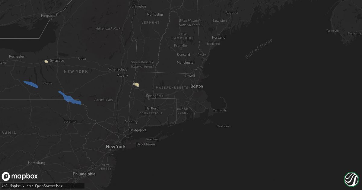
Hail Map in Massachusetts on July 27, 2021
Get this storm
July 27 map
$229
one time, instant access
Download today. No call, no setup
Keep the $229
Bought the map and want the full workflow? Apply the entire $229 to a subscription within 7 days. None of it is wasted.
Every map, not just this one
This buys you this map. Subscription and you get every map we run, in the markets you choose from a few cities to whole states to nationwide. Plus real-time alerts the moment a storm fires.
Contact data
Name, contact info, occupancy, even credit band for addresses in the footprint. You go from where it hit to who to call.
Become the source they trust
Unlimited branding weather history reports on demand. You already have the documented answer ready for the property owner, and you are the one who showed up with it.
Property data and RoofTrace estimates
Pull up any address you have got, its value and the exact code rules for that jurisdiction, straight from One Click Code. Then RoofTrace estimates the squares, pitch, and roof value, priced the way you price.
Storm reports in Massachusetts
Massachusetts
| Date | Description |
|---|---|
| 07/27/20216:59 PM CDT | Tree down on wires on north truro rd in hingham |
| 07/27/20216:40 PM CDT | Tree down on car on evans and west squantum streets... Person trapped and extricated... Uninjured. Relayed by amateur radio. |
| 07/27/20216:40 PM CDT | Tree down on 49 nelson st in quincy. Relayed by amateur radio |
| 07/27/20216:40 PM CDT | Tree down blocking road on furnace brook pkwy in quincy. Relayed by amateur radio. |
| 07/27/20216:36 PM CDT | Tree down on englewood ave in brighton. Relayed by amateur radio. |
| 07/27/20216:35 PM CDT | A local report indicates 61 MPH wind near LOGAN AP |
| 07/27/20216:34 PM CDT | Tree down in the roadway on crushing street. Tree down on car on clinton street. Tree down on carberry street. Tree and wires down and leaning on a house on governors a |
| 07/27/20216:30 PM CDT | Tree down on house in the area of 101 pearl street. Small tree down on car on bonair street. Relayed by amateur radio. |
| 07/27/20216:27 PM CDT | Tree down on adams street at wiltshire road. Relayed by amateur radio. |
| 07/27/20216:27 PM CDT | Tree down on haven st and church st intesection in dover. Relayed by amateur radio. |
| 07/27/20216:27 PM CDT | Power lines down on cummings road. Relayed by amateur radio. |
| 07/27/20216:27 PM CDT | Power lines down on wales street. Relayed by amateur radio. |
| 07/27/20216:27 PM CDT | Tree down near the channel 7 news station on bullfinch place. |
| 07/27/20216:27 PM CDT | Tree down on fresh pond parkway. Tree down and blocking antrim street. Relayed by amateur radio. |
| 07/27/20216:27 PM CDT | Tree down on a car on everett st |
| 07/27/20216:27 PM CDT | Tree down across cricuit drive; power lines down on neponset valley parkway... Two trees down on 400 block of marlboro street... Large branch down on car on 1300 block |
| 07/27/20216:27 PM CDT | Large branch down on lower south street next to arnold street. Relayed by amateur radio. |
| 07/27/20216:26 PM CDT | Branches down on the mass pike |
| 07/27/20216:26 PM CDT | Tree and wires down at 33 brown street. Relayed by amateur radio. |
| 07/27/20216:21 PM CDT | Tree down blocking the street near 19 park drive. Tree down on a house at 111 prospect street. Relayed by amateur radio. |
| 07/27/20216:21 PM CDT | Tree down on a car on commonwealth ave in newton |
| 07/27/20216:19 PM CDT | Tree down on south main street at bullard road. Rleayed by amateur radio. |
| 07/27/20216:18 PM CDT | Large branch down near 33 cedar street. Relayed by amateur radio. |
| 07/27/20216:10 PM CDT | Tree down on a house at 88 kendall lane. Relayed by amateur radio. |
| 07/27/20216:00 PM CDT | Tree down near 8 north main street. Relayed by amateur radio. |
| 07/27/20215:55 PM CDT | Tree and wires down at 7 arch street. Relayed by amateur radio. |
| 07/27/20215:48 PM CDT | Siding blown off the side of a house on brigham streeet near south street. Relayed by amateur radio. |
| 07/27/20215:45 PM CDT | Tree down partially blocking road at 1222 pleasant street. Relayed by amateur radio. |
| 07/27/20215:40 PM CDT | Two trees down on hillando drive near walnut street. Relayed by amateur radio. |
| 07/27/20215:40 PM CDT | 4-5 foot diameter tree down at corner of main street and paul tivman road. Large branch down at the corner of belair street and main street. |
| 07/27/20215:40 PM CDT | Large tree downed on main and mill st in boylston. |
| 07/27/20215:38 PM CDT | Tree down on a car at 61 briar lane. Power lines down on tacoma street and clark street. Tree and wires down blocking road on quinapoxet lane near bergstrom road. Relay |
| 07/27/20215:38 PM CDT | Tree down on top of a car. Wires down. Relayed by amateur radio. |
| 07/27/20215:33 PM CDT | Tree down on wires between 73 and 95 mccormick road. Relayed by amateur radio. |
| 07/27/20215:32 PM CDT | A local report indicates 65 MPH wind near HOLDEN |
| 07/27/20215:31 PM CDT | Tree down blocking west road near padre road. Relayed by amateur radio. |
| 07/27/20215:28 PM CDT | Wires down near 1004 north west street. |
| 07/27/20215:28 PM CDT | Utility pole down on route 20 at dewey street. Tree down on wires birnie ave. |
| 07/27/20215:25 PM CDT | Tree downed across route 8 |
| 07/27/20215:23 PM CDT | Tree down blocking west road near padre road. Relayed by amateur radio. |
| 07/27/20215:20 PM CDT | A local report indicates 60 MPH wind near HOLDEN |
| 07/27/20215:15 PM CDT | Tree and wires down behind a home at 750 williamsville road. Relayed by amateur radio. |
| 07/27/20215:13 PM CDT | Tree down near 185 huntington road |
| 07/27/20215:06 PM CDT | Tree down on wires near 46 bray road. Relayed by amateur radio. |
| 07/27/20214:46 PM CDT | Wires down on amherst road near enfield road. Relayed by amateur radio. |
| 07/27/20214:45 PM CDT | Tree branches down on south whitney street by college street... And also on east pleasant street by owen drive. Wires down on 34 baker street. Relayed by amateur radio. |
| 07/27/20214:40 PM CDT | Tree down at 90 lindseed road. Tree down on arnold road. Relayed by amateur radio. |
| 07/27/20214:39 PM CDT | Tree down on wires. Relayed by amateur radio. |
| 07/27/20214:31 PM CDT | Tree in down on haydenville road by westbrook road. Tree down on i-91 south. Relayed by amateur radio. |
| 07/27/20214:31 PM CDT | Tree down on lower road. Relayed by amateur radio. |
| 07/27/20214:28 PM CDT | Trees downed on a house on new lenox road |
| 07/27/20214:27 PM CDT | Tree and wires downed on a house on east street |
| 07/27/20214:26 PM CDT | Wires downed at the corner of housatonic street and high street |
| 07/27/20214:24 PM CDT | Tree downed on circular avenue |
| 07/27/20214:23 PM CDT | Tree down on route 9. Tree down on berkshire trail. Relayed by amateur radio. |
| 07/27/20214:20 PM CDT | Trees and wires down on plainfield road |
| 07/27/20214:18 PM CDT | Wires down on main street |
| 07/27/20213:50 PM CDT | Tree downed across route 8 |
| 07/27/20213:50 PM CDT | Tree downed |
| 07/27/20213:47 PM CDT | Wires downed on bridge street |
| 07/27/20213:47 PM CDT | Tree downed on balance road road |
| 07/27/20211:33 AM CDT | At 632 PM EDT, severe thunderstorms were located along a line extending from near Fitchburg to Leicester, moving east at 40 mph. HAZARD...60 mph wind gusts and nickel size hail. SOURCE...Radar indicated. IMPACT...Expect damage to trees and power lines. Locations impacted include... Boston, Worcester, Cambridge, Brockton, Quincy, Newton, Somerville, Framingham, Waltham, Malden, Brookline, Medford, Weymouth, Revere, Arlington, Everett, Leominster, Fitchburg, Billerica and Marlborough. |
| 07/27/202112:04 AM CDT | At 503 PM EDT, a severe thunderstorm was located over East Windsor, or 15 miles east of Pittsfield, moving southeast at 40 mph. HAZARD...60 mph wind gusts and quarter size hail. SOURCE...Radar indicated. This storm has downed trees in portions of central Berkshire County. IMPACT...Expect wind damage to trees and power lines. Minor hail damage to vehicles is possible. Locations impacted include... Springfield, Chicopee, Holyoke, Amherst, Northampton, Deerfield, Ludlow, South Hadley, Easthampton, Belchertown, Wilbraham, Ware, Montague, Granby, Southampton, Hadley, Sunderland, Hatfield, Williamsburg and Huntington. |
| 07/26/202111:30 PM CDT | At 429 PM EDT, severe thunderstorms were located along a line extending from near Pownal to near Hancock to near Stephentown, moving east at 25 mph. HAZARD...60 mph wind gusts and nickel size hail. SOURCE...Radar indicated. IMPACT...Expect damage to roofs, siding, and trees. Locations impacted include... Pittsfield, North Adams, Adams, Williamstown, Cheshire, Stephentown, Florida, Hancock, Savoy, New Ashford, Berkshire, Dalton, Lanesborough, Hinsdale, Windsor, Peru, East Nassau, Hairpin Turn, Barkerville and Greylock. |
All States Impacted by Hail Map on July 27, 2021
Cities Impacted by Hail Map on July 27, 2021
- Norcross, MN
- Herman, MN
- Dumont, MN
- Cyrus, MN
- Elbow Lake, MN
- Hancock, MN
- Tintah, MN
- Chokio, MN
- Starbuck, MN
- Donnelly, MN
- Morris, MN
- Mildred, PA
- Dushore, PA
- Osakis, MN
- Sauk Centre, MN
- Sulphur, LA
- Decorah, IA
- Waukon, IA
- Postville, IA
- Dorchester, IA
- Unadilla, GA
- Willard, WI
- Fairchild, WI
- Commerce, TX
- Greenville, TX
- Campbell, TX
- Park Rapids, MN
- Shevlin, MN
- Kirbyville, TX
- Blossom, TX
- Wahpeton, ND
- Ettrick, WI
- Melrose, WI
- Mindoro, WI
- Galesville, WI
- Holmen, WI
- Rockland, WI
- Taylor, WI
- Bangor, WI
- West Salem, WI
- Arcadia, WI
- Luana, IA
- Monona, IA
- Nashoba, OK
- Rattan, OK
- Snow, OK
- Hoffman Estates, IL
- Palatine, IL
- Barrington, IL
- Arlington Heights, IL
- Rolling Meadows, IL
- Ponce De Leon, FL
- Cleveland, TX
- North Wilkesboro, NC
- Wilkesboro, NC
- Campbell, MN
- Fairmount, ND
- Lenox, MA
- Pittsfield, MA
- Livingston, WI
- Stitzer, WI
- Platteville, WI
- Lancaster, WI
- Chidester, AR
- Glen Haven, WI
- Bloomington, WI
- Bagley, WI
- Sabin, MN
- Wolverton, MN
- Moorhead, MN
- Taylorsville, NC
- Vienna, GA
- Blair, WI
- Trempealeau, WI
- Dodge, WI
- Sparta, WI
- Menahga, MN
- Nevis, MN
- Winthrop, AR
- Horatio, AR
- Maynard, IA
- Gainesville, TX
- Whitesboro, TX
- Oakfield, GA
- Damascus, GA
- Orange, TX
- Hixton, WI
- Richmond, MA
- Becket, MA
- Lee, MA
- Dalton, MA
- Ignacio, CO
- Honey Grove, TX
- Elko, GA
- East Dubuque, IL
- Bellevue, IA
- Eagle Bend, MN
- Hawkeye, IA
- Quasqueton, IA
- Stanley, IA
- Randalia, IA
- Independence, IA
- Waucoma, IA
- Lawler, IA
- Sumner, IA
- Oelwein, IA
- Fayette, IA
- Hazleton, IA
- Fredericksburg, IA
- New Hampton, IA
- Aurora, IA
- Winthrop, IA
- Arlington, IA
- Westgate, IA
- West Union, IA
- Brandon, MS
- Bienville, LA
- Albany, GA
- Sylvester, GA
- Stoddard, WI
- Gillham, AR
- De Queen, AR
- Farmersburg, IA
- Ronda, NC
- Hokah, MN
- Holy Cross, IA
- North Buena Vista, IA
- Cassville, WI
- Guttenberg, IA
- Staples, MN
- Sebeka, MN
- Horace, ND
- Kindred, ND
- Genoa, WI
- Roaring River, NC
- Columbiana, AL
- Alabaster, AL
- Brantley, AL
- Elba, AL
- Ben Franklin, TX
- Black River Falls, WI
- South Beloit, IL
- Clinton, WI
- Burkeville, TX
- Houston, MN
- Caledonia, MN
- Dublin, GA
- Alpharetta, GA
- Naytahwaush, MN
- La Valle, WI
- Cazenovia, WI
- Weedsport, NY
- Auburn, NY
- Elbridge, NY
- Osseo, WI
- Oregon, WI
- Cragford, AL
- Dassel, MN
- Hutchinson, MN
- Cokato, MN
- Detroit, TX
- Paris, TX
- Roanoke, AL
- Wadley, AL
- Melrose, MN
- Cuba City, WI
- Belmont, WI
- Coushatta, LA
- Campti, LA
- Wyndmere, ND
- Leonard, ND
- Walcott, ND
- Frazee, MN
- Camp Hill, AL
- Kelly, LA
- Grayson, LA
- Chester, IA
- Alexander City, AL
- Kellyton, AL
- Lowell, IN
- Crown Point, IN
- Winger, MN
- Bejou, MN
- Mahnomen, MN
- Harrisonburg, LA
- Dayton, TX
- Fort Worth, TX
- De Soto, WI
- Beecher, IL
- Arkadelphia, AR
- Bagley, MN
- Ponsford, MN
- Plainfield, IL
- Naperville, IL
- Roslyn, SD
- Grenville, SD
- Washington, AR
- Roswell, GA
- Enterprise, MS
- Elgin, MN
- Nashua, MN
- Joliet, IL
- Shorewood, IL
- Pittsview, AL
- Parkers Prairie, MN
- Miltona, MN
- Carlos, MN
- Enderlin, ND
- Deridder, LA
- Hiddenite, NC
- Statesville, NC
- Rembert, SC
- Adrian, GA
- East Dublin, GA
- Ball, LA
- Lafayette, AL
- Galena, IL
- Columbus, GA
- Brownsville, MN
- Glenmora, LA
- Winona, MN
- Jasper, GA
- Ball Ground, GA
- Canton, GA
- Stockbridge, GA
- Wheatland, ND
- Shepherd, TX
- Sheldon, ND
- Chatfield, MN
- Louisville, AL
- Jasper, TX
- Fosston, MN
- Fertile, MN
- Boscobel, WI
- Mount Hope, WI
- Fennimore, WI
- Wauzeka, WI
- Woodman, WI
- Roxton, TX
- Cooper, TX
- Villard, MN
- Glenwood, MN
- Dubuque, IA
- Arlington, GA
- Leary, GA
- La Crosse, WI
- New Albin, IA
- Chaseburg, WI
- Lansing, IA
- Harpers Ferry, IA
- Dakota, MN
- Ferryville, WI
- Coon Valley, WI
- La Crescent, MN
- Viroqua, WI
- Onalaska, WI
- Calera, AL
- Liberty, TX
- Alma Center, WI
- Elkin, NC
- Daviston, AL
- Honobia, OK
- Smithville, OK
- Vicksburg, MS
- Converse, LA
- Pelican, LA
- Colmesneil, TX
- Jordan, NY
- Moravian Falls, NC
- Fort Atkinson, IA
- Saint Lucas, IA
- Riceville, IA
- Le Roy, MN
- Oswego, IL
- Gladstone, VA
- Lawrenceville, GA
- Eyota, MN
- Bronson, TX
- Mount Carroll, IL
- Port Byron, NY
- Watson, OK
- Pollock, LA
- Barrett, MN
- Newton, GA
- Belfield, ND
- Deer Creek, MN
- Saline, LA
- Eufaula, AL
- Granite Falls, NC
- Christine, ND
- Barnesville, MN
- Deport, TX
- Bogata, TX
- Madill, OK
- Mannsville, OK
- Oscar, LA
- Ventress, LA
- Jarreau, LA
- Verona, WI
- Madison, WI
- Alma, WI
- Cochrane, WI
- Lime Springs, IA
- Alta Vista, IA
- Elma, IA
- Langford, SD
- Weatherford, TX
- Spring Valley, MN
- Sharon, WI
- Delta, AL
- Lineville, AL
- Ashland, AL
- Reynolds, GA
- Butler, GA
- Clinton, IA
- Miles, IA
- Johnston, SC
- Warwick, GA
- Fonda, NY
- Opp, AL
- Wetumpka, AL
- Elmore, AL
- Traphill, NC
- Hays, NC
- Dadeville, AL
- Kellogg, MN
- Colesburg, IA
- Sherrill, IA
- Boyce, LA
- Elmer, LA
- Childersburg, AL
- Jacksons Gap, AL
- Belgrade, MN
- Brooten, MN
- Alapaha, GA
- Bluffton, MN
- Wadena, MN
- New York Mills, MN
- Marietta, GA
- Eastaboga, AL
- Oxford, AL
- Munford, AL
- Decatur, GA
- Atlanta, GA
- Motley, MN
- Pine River, MN
- Prairie Du Chien, WI
- Paint Rock, TX
- Eden, TX
- Hineston, LA
- Ladonia, TX
- Cordele, GA
- Springtown, TX
- Long Prairie, MN
- Heavener, OK
- Pinehurst, GA
- Altura, MN
- Rex, GA
- Ellenwood, GA
- Sylacauga, AL
- Lenoir, NC
- Fred, TX
- Cashton, WI
- Norwalk, WI
- Stewartville, MN
- Wykoff, MN
- Cross Hill, SC
- Mountville, SC
- Pittsville, WI
- Marshfield, WI
- Granton, WI
- Jackson Springs, NC
- Mount Holly, AR
- Peosta, IA
- Paducah, TX
- Snellville, GA
- Belcher, LA
- Leonard, MN
- Wilmot, SD
- Henning, MN
- Protivin, IA
- Calmar, IA
- Cresco, IA
- Ridgeway, IA
- Red Oak, OK
- Wister, OK
- Lengby, MN
- Eastman, WI
- Robeline, LA
- Pleasant Hill, LA
- Marthaville, LA
- Harpersville, AL
- Evans, LA
- Leesville, LA
- Freeport, MN
- Paynesville, MN
- Milburn, OK
- Tishomingo, OK
- Saratoga, AR
- Ashdown, AR
- Fulton, AR
- Pittsburg, OK
- Humbird, WI
- Bertha, MN
- Hewitt, MN
- Morganton, NC
- Valdese, NC
- Talihina, OK
- Wilburton, OK
- Hawkinsville, GA
- Woodstock, GA
- Eitzen, MN
- Coleman, GA
- Merrillan, WI
- Neillsville, WI
- Headland, AL
- Ashford, AL
- Webb, AL
- Alexandria, LA
- Dothan, AL
- Cowarts, AL
- Zwolle, LA
- Noble, LA
- Muncy Valley, PA
- Lopez, PA
- Colfax, ND
- Bedford, VA
- Wewoka, OK
- Colquitt, GA
- Janesville, WI
- Peever, SD
- Douglas, GA
- Willacoochee, GA
- Savanna, IL
- Mapleton, ND
- Mooringsport, LA
- Oil City, LA
- Iowa, LA
- Shullsburg, WI
- Scales Mound, IL
- Molena, GA
- Thomaston, GA
- Fitzhugh, OK
- Blakely, GA
- Garnavillo, IA
- Epworth, IA
- Durango, IA
- Beloit, WI
- Patagonia, AZ
- Duluth, GA
- Hanover, IL
- Elizabeth, IL
- Wickes, AR
- Stapleton, GA
- Rayville, LA
- Candor, NC
- Sicily Island, LA
- Lake Charles, LA
- Dequincy, LA
- Kinder, LA
- Ragley, LA
- Fargo, ND
- West Fargo, ND
- Smithville, GA
- Leesburg, GA
- Fort Payne, AL
- Wilton, WI
- Ontario, WI
- Haynesville, LA
- Breckenridge, TX
- Caddo, TX
- Preston, MN
- Harmony, MN
- Boonville, NC
- State Road, NC
- Jonesville, NC
- Jacksboro, TX
- Richmond, MN
- Ostrander, MN
- Olla, LA
- Ada, OK
- Doerun, GA
- Augusta, WI
- Spring Grove, MN
- Elkader, IA
- Saint Olaf, IA
- Columbia, AL
- Newville, AL
- Mittie, LA
- Dry Creek, LA
- Vinton, LA
- Foreman, AR
- Mcleod, ND
- Hebron, IN
- Bagwell, TX
- Clarksville, TX
- Henning, TN
- Ripley, TN
- Vivian, LA
- Lithonia, GA
- Camilla, GA
- Sale City, GA
- Whitehall, WI
- Winthrop, MN
- Jefferson, TX
- Fountain City, WI
- Uniontown, AR
- Rudy, AR
- Chester, AR
- Van Buren, AR
- Cedarville, AR
- Hartshorne, OK
- Elizabeth, LA
- Pitkin, LA
- Defuniak Springs, FL
- Dover, MN
- Rochester, MN
- Millville, MN
- Zumbro Falls, MN
- Pineville, LA
- Deville, LA
- Faber, VA
- Lovingston, VA
- Nellysford, VA
- Alpine, AL
- Talladega, AL
- Morris, GA
- Sumner, GA
- Ashburn, GA
- Lamont, IA
- Bath, NY
- Montour Falls, NY
- Beaver Dams, NY
- Millport, NY
- Watkins Glen, NY
- Prattsburgh, NY
- Dundee, NY
- Bradford, NY
- Hammondsport, NY
- Rock Stream, NY
- Maine, NY
- Newark Valley, NY
- Thompson, PA
- Preston Park, PA
- Starrucca, PA
- Brackney, PA
- Lake Como, PA
- Hancock, NY
- Johnson City, NY
- Lakewood, PA
- Castle Creek, NY
- Binghamton, NY
- Windsor, NY
- Glen Aubrey, NY
- Hallstead, PA
- Kirkwood, NY
- Starlight, PA
- Great Bend, PA
- Equinunk, PA
- Conklin, NY
- Susquehanna, PA
- Endicott, NY
- Greenwood, WI


