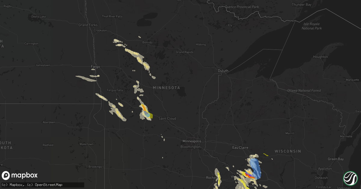
Hail Map in Minnesota on July 27, 2021
Get this storm
July 27 map
$229
one time, instant access
Download today. No call, no setup
Keep the $229
Bought the map and want the full workflow? Apply the entire $229 to a subscription within 7 days. None of it is wasted.
Every map, not just this one
This buys you this map. Subscription and you get every map we run, in the markets you choose from a few cities to whole states to nationwide. Plus real-time alerts the moment a storm fires.
Contact data
Name, contact info, occupancy, even credit band for addresses in the footprint. You go from where it hit to who to call.
Become the source they trust
Unlimited branding weather history reports on demand. You already have the documented answer ready for the property owner, and you are the one who showed up with it.
Property data and RoofTrace estimates
Pull up any address you have got, its value and the exact code rules for that jurisdiction, straight from One Click Code. Then RoofTrace estimates the squares, pitch, and roof value, priced the way you price.
Storm reports in Minnesota
Minnesota
| Date | Description |
|---|---|
| 07/27/20218:17 AM CDT | A local report indicates 1.00 inch wind near 1 W LA CRESCENT |
| 07/27/20218:17 AM CDT | A local report indicates 1.25 inch wind near LA CRESCENT |
| 07/27/20218:14 AM CDT | A local report indicates 1.00 inch wind near LA CRESCENT |
| 07/27/20216:52 AM CDT | A few large hail in very heavy rain and strong winds reported near island lake. Time estimated based on radar. |
| 07/27/20215:15 AM CDT | Mesonet station mn016 sauk centre 2se. |
| 07/27/20215:10 AM CDT | Numerous trees uprooted and a few snapped. |
| 07/27/20214:48 AM CDT | At 948 PM CDT, a severe thunderstorm was located near Chatfield, or 15 miles southeast of Rochester, moving southeast at 15 mph. HAZARD...Quarter size hail. SOURCE...Radar indicated. IMPACT...Damage to vehicles is expected. This severe thunderstorm will be near... Chatfield around 955 PM CDT. Wykoff around 1025 PM CDT. Preston and Fountain around 1030 PM CDT.Other locations impacted by this severe thunderstorm include CountyRoads 2 And 38, Forestville State Park, Carimona, Fillmore, CountyRoads 2 And 101, Cummingsville and Washington. |
| 07/27/20214:16 AM CDT | At 915 AM CDT, a severe thunderstorm was located 9 miles east of New Albin, or 11 miles west of Viroqua, moving south at 40 mph. HAZARD...Quarter size hail. SOURCE...Radar indicated. IMPACT...Damage to vehicles is expected. This severe thunderstorm will remain over mainly rural areas of southwestern Vernon and Crawford Counties, including the following locations... Eastman, Red Mound, Rush Creek, Harris Ridge, Fairview, Bud and Maple Ridge. |
| 07/27/20214:16 AM CDT | At 915 PM CDT, a severe thunderstorm was located over Eyota, or 11 miles east of Rochester, moving southeast at 20 mph. HAZARD...60 mph wind gusts and quarter size hail. SOURCE...Public. Quarter sized hail was reported north of Eyota. IMPACT...Hail damage to vehicles is expected. Expect wind damage to roofs, siding, and trees. This severe thunderstorm will be near... Eyota around 920 PM CDT. Dover around 930 PM CDT. St. Charles around 935 PM CDT. Chatfield around 945 PM CDT.Other locations impacted by this severe thunderstorm include Chester,Ringe, Saratoga, County Roads 9 And 10, County Roads 137 And 136,Highway 30 And County 74 and Viola.This includes Interstate 90 in Minnesota between mile markers 220 and238. |
| 07/26/202110:05 PM CDT | Wind gust from a home weather station northwest of wykoff. |
| 07/26/20219:10 PM CDT | Public report via twitter and kaal tv. |
All States Impacted by Hail Map on July 27, 2021
Cities Impacted by Hail Map on July 27, 2021
- Norcross, MN
- Herman, MN
- Dumont, MN
- Cyrus, MN
- Elbow Lake, MN
- Hancock, MN
- Tintah, MN
- Chokio, MN
- Starbuck, MN
- Donnelly, MN
- Morris, MN
- Mildred, PA
- Dushore, PA
- Osakis, MN
- Sauk Centre, MN
- Sulphur, LA
- Decorah, IA
- Waukon, IA
- Postville, IA
- Dorchester, IA
- Unadilla, GA
- Willard, WI
- Fairchild, WI
- Commerce, TX
- Greenville, TX
- Campbell, TX
- Park Rapids, MN
- Shevlin, MN
- Kirbyville, TX
- Blossom, TX
- Wahpeton, ND
- Ettrick, WI
- Melrose, WI
- Mindoro, WI
- Galesville, WI
- Holmen, WI
- Rockland, WI
- Taylor, WI
- Bangor, WI
- West Salem, WI
- Arcadia, WI
- Luana, IA
- Monona, IA
- Nashoba, OK
- Rattan, OK
- Snow, OK
- Hoffman Estates, IL
- Palatine, IL
- Barrington, IL
- Arlington Heights, IL
- Rolling Meadows, IL
- Ponce De Leon, FL
- Cleveland, TX
- North Wilkesboro, NC
- Wilkesboro, NC
- Campbell, MN
- Fairmount, ND
- Lenox, MA
- Pittsfield, MA
- Livingston, WI
- Stitzer, WI
- Platteville, WI
- Lancaster, WI
- Chidester, AR
- Glen Haven, WI
- Bloomington, WI
- Bagley, WI
- Sabin, MN
- Wolverton, MN
- Moorhead, MN
- Taylorsville, NC
- Vienna, GA
- Blair, WI
- Trempealeau, WI
- Dodge, WI
- Sparta, WI
- Menahga, MN
- Nevis, MN
- Winthrop, AR
- Horatio, AR
- Maynard, IA
- Gainesville, TX
- Whitesboro, TX
- Oakfield, GA
- Damascus, GA
- Orange, TX
- Hixton, WI
- Richmond, MA
- Becket, MA
- Lee, MA
- Dalton, MA
- Ignacio, CO
- Honey Grove, TX
- Elko, GA
- East Dubuque, IL
- Bellevue, IA
- Eagle Bend, MN
- Hawkeye, IA
- Quasqueton, IA
- Stanley, IA
- Randalia, IA
- Independence, IA
- Waucoma, IA
- Lawler, IA
- Sumner, IA
- Oelwein, IA
- Fayette, IA
- Hazleton, IA
- Fredericksburg, IA
- New Hampton, IA
- Aurora, IA
- Winthrop, IA
- Arlington, IA
- Westgate, IA
- West Union, IA
- Brandon, MS
- Bienville, LA
- Albany, GA
- Sylvester, GA
- Stoddard, WI
- Gillham, AR
- De Queen, AR
- Farmersburg, IA
- Ronda, NC
- Hokah, MN
- Holy Cross, IA
- North Buena Vista, IA
- Cassville, WI
- Guttenberg, IA
- Staples, MN
- Sebeka, MN
- Horace, ND
- Kindred, ND
- Genoa, WI
- Roaring River, NC
- Columbiana, AL
- Alabaster, AL
- Brantley, AL
- Elba, AL
- Ben Franklin, TX
- Black River Falls, WI
- South Beloit, IL
- Clinton, WI
- Burkeville, TX
- Houston, MN
- Caledonia, MN
- Dublin, GA
- Alpharetta, GA
- Naytahwaush, MN
- La Valle, WI
- Cazenovia, WI
- Weedsport, NY
- Auburn, NY
- Elbridge, NY
- Osseo, WI
- Oregon, WI
- Cragford, AL
- Dassel, MN
- Hutchinson, MN
- Cokato, MN
- Detroit, TX
- Paris, TX
- Roanoke, AL
- Wadley, AL
- Melrose, MN
- Cuba City, WI
- Belmont, WI
- Coushatta, LA
- Campti, LA
- Wyndmere, ND
- Leonard, ND
- Walcott, ND
- Frazee, MN
- Camp Hill, AL
- Kelly, LA
- Grayson, LA
- Chester, IA
- Alexander City, AL
- Kellyton, AL
- Lowell, IN
- Crown Point, IN
- Winger, MN
- Bejou, MN
- Mahnomen, MN
- Harrisonburg, LA
- Dayton, TX
- Fort Worth, TX
- De Soto, WI
- Beecher, IL
- Arkadelphia, AR
- Bagley, MN
- Ponsford, MN
- Plainfield, IL
- Naperville, IL
- Roslyn, SD
- Grenville, SD
- Washington, AR
- Roswell, GA
- Enterprise, MS
- Elgin, MN
- Nashua, MN
- Joliet, IL
- Shorewood, IL
- Pittsview, AL
- Parkers Prairie, MN
- Miltona, MN
- Carlos, MN
- Enderlin, ND
- Deridder, LA
- Hiddenite, NC
- Statesville, NC
- Rembert, SC
- Adrian, GA
- East Dublin, GA
- Ball, LA
- Lafayette, AL
- Galena, IL
- Columbus, GA
- Brownsville, MN
- Glenmora, LA
- Winona, MN
- Jasper, GA
- Ball Ground, GA
- Canton, GA
- Stockbridge, GA
- Wheatland, ND
- Shepherd, TX
- Sheldon, ND
- Chatfield, MN
- Louisville, AL
- Jasper, TX
- Fosston, MN
- Fertile, MN
- Boscobel, WI
- Mount Hope, WI
- Fennimore, WI
- Wauzeka, WI
- Woodman, WI
- Roxton, TX
- Cooper, TX
- Villard, MN
- Glenwood, MN
- Dubuque, IA
- Arlington, GA
- Leary, GA
- La Crosse, WI
- New Albin, IA
- Chaseburg, WI
- Lansing, IA
- Harpers Ferry, IA
- Dakota, MN
- Ferryville, WI
- Coon Valley, WI
- La Crescent, MN
- Viroqua, WI
- Onalaska, WI
- Calera, AL
- Liberty, TX
- Alma Center, WI
- Elkin, NC
- Daviston, AL
- Honobia, OK
- Smithville, OK
- Vicksburg, MS
- Converse, LA
- Pelican, LA
- Colmesneil, TX
- Jordan, NY
- Moravian Falls, NC
- Fort Atkinson, IA
- Saint Lucas, IA
- Riceville, IA
- Le Roy, MN
- Oswego, IL
- Gladstone, VA
- Lawrenceville, GA
- Eyota, MN
- Bronson, TX
- Mount Carroll, IL
- Port Byron, NY
- Watson, OK
- Pollock, LA
- Barrett, MN
- Newton, GA
- Belfield, ND
- Deer Creek, MN
- Saline, LA
- Eufaula, AL
- Granite Falls, NC
- Christine, ND
- Barnesville, MN
- Deport, TX
- Bogata, TX
- Madill, OK
- Mannsville, OK
- Oscar, LA
- Ventress, LA
- Jarreau, LA
- Verona, WI
- Madison, WI
- Alma, WI
- Cochrane, WI
- Lime Springs, IA
- Alta Vista, IA
- Elma, IA
- Langford, SD
- Weatherford, TX
- Spring Valley, MN
- Sharon, WI
- Delta, AL
- Lineville, AL
- Ashland, AL
- Reynolds, GA
- Butler, GA
- Clinton, IA
- Miles, IA
- Johnston, SC
- Warwick, GA
- Fonda, NY
- Opp, AL
- Wetumpka, AL
- Elmore, AL
- Traphill, NC
- Hays, NC
- Dadeville, AL
- Kellogg, MN
- Colesburg, IA
- Sherrill, IA
- Boyce, LA
- Elmer, LA
- Childersburg, AL
- Jacksons Gap, AL
- Belgrade, MN
- Brooten, MN
- Alapaha, GA
- Bluffton, MN
- Wadena, MN
- New York Mills, MN
- Marietta, GA
- Eastaboga, AL
- Oxford, AL
- Munford, AL
- Decatur, GA
- Atlanta, GA
- Motley, MN
- Pine River, MN
- Prairie Du Chien, WI
- Paint Rock, TX
- Eden, TX
- Hineston, LA
- Ladonia, TX
- Cordele, GA
- Springtown, TX
- Long Prairie, MN
- Heavener, OK
- Pinehurst, GA
- Altura, MN
- Rex, GA
- Ellenwood, GA
- Sylacauga, AL
- Lenoir, NC
- Fred, TX
- Cashton, WI
- Norwalk, WI
- Stewartville, MN
- Wykoff, MN
- Cross Hill, SC
- Mountville, SC
- Pittsville, WI
- Marshfield, WI
- Granton, WI
- Jackson Springs, NC
- Mount Holly, AR
- Peosta, IA
- Paducah, TX
- Snellville, GA
- Belcher, LA
- Leonard, MN
- Wilmot, SD
- Henning, MN
- Protivin, IA
- Calmar, IA
- Cresco, IA
- Ridgeway, IA
- Red Oak, OK
- Wister, OK
- Lengby, MN
- Eastman, WI
- Robeline, LA
- Pleasant Hill, LA
- Marthaville, LA
- Harpersville, AL
- Evans, LA
- Leesville, LA
- Freeport, MN
- Paynesville, MN
- Milburn, OK
- Tishomingo, OK
- Saratoga, AR
- Ashdown, AR
- Fulton, AR
- Pittsburg, OK
- Humbird, WI
- Bertha, MN
- Hewitt, MN
- Morganton, NC
- Valdese, NC
- Talihina, OK
- Wilburton, OK
- Hawkinsville, GA
- Woodstock, GA
- Eitzen, MN
- Coleman, GA
- Merrillan, WI
- Neillsville, WI
- Headland, AL
- Ashford, AL
- Webb, AL
- Alexandria, LA
- Dothan, AL
- Cowarts, AL
- Zwolle, LA
- Noble, LA
- Muncy Valley, PA
- Lopez, PA
- Colfax, ND
- Bedford, VA
- Wewoka, OK
- Colquitt, GA
- Janesville, WI
- Peever, SD
- Douglas, GA
- Willacoochee, GA
- Savanna, IL
- Mapleton, ND
- Mooringsport, LA
- Oil City, LA
- Iowa, LA
- Shullsburg, WI
- Scales Mound, IL
- Molena, GA
- Thomaston, GA
- Fitzhugh, OK
- Blakely, GA
- Garnavillo, IA
- Epworth, IA
- Durango, IA
- Beloit, WI
- Patagonia, AZ
- Duluth, GA
- Hanover, IL
- Elizabeth, IL
- Wickes, AR
- Stapleton, GA
- Rayville, LA
- Candor, NC
- Sicily Island, LA
- Lake Charles, LA
- Dequincy, LA
- Kinder, LA
- Ragley, LA
- Fargo, ND
- West Fargo, ND
- Smithville, GA
- Leesburg, GA
- Fort Payne, AL
- Wilton, WI
- Ontario, WI
- Haynesville, LA
- Breckenridge, TX
- Caddo, TX
- Preston, MN
- Harmony, MN
- Boonville, NC
- State Road, NC
- Jonesville, NC
- Jacksboro, TX
- Richmond, MN
- Ostrander, MN
- Olla, LA
- Ada, OK
- Doerun, GA
- Augusta, WI
- Spring Grove, MN
- Elkader, IA
- Saint Olaf, IA
- Columbia, AL
- Newville, AL
- Mittie, LA
- Dry Creek, LA
- Vinton, LA
- Foreman, AR
- Mcleod, ND
- Hebron, IN
- Bagwell, TX
- Clarksville, TX
- Henning, TN
- Ripley, TN
- Vivian, LA
- Lithonia, GA
- Camilla, GA
- Sale City, GA
- Whitehall, WI
- Winthrop, MN
- Jefferson, TX
- Fountain City, WI
- Uniontown, AR
- Rudy, AR
- Chester, AR
- Van Buren, AR
- Cedarville, AR
- Hartshorne, OK
- Elizabeth, LA
- Pitkin, LA
- Defuniak Springs, FL
- Dover, MN
- Rochester, MN
- Millville, MN
- Zumbro Falls, MN
- Pineville, LA
- Deville, LA
- Faber, VA
- Lovingston, VA
- Nellysford, VA
- Alpine, AL
- Talladega, AL
- Morris, GA
- Sumner, GA
- Ashburn, GA
- Lamont, IA
- Bath, NY
- Montour Falls, NY
- Beaver Dams, NY
- Millport, NY
- Watkins Glen, NY
- Prattsburgh, NY
- Dundee, NY
- Bradford, NY
- Hammondsport, NY
- Rock Stream, NY
- Maine, NY
- Newark Valley, NY
- Thompson, PA
- Preston Park, PA
- Starrucca, PA
- Brackney, PA
- Lake Como, PA
- Hancock, NY
- Johnson City, NY
- Lakewood, PA
- Castle Creek, NY
- Binghamton, NY
- Windsor, NY
- Glen Aubrey, NY
- Hallstead, PA
- Kirkwood, NY
- Starlight, PA
- Great Bend, PA
- Equinunk, PA
- Conklin, NY
- Susquehanna, PA
- Endicott, NY
- Greenwood, WI


