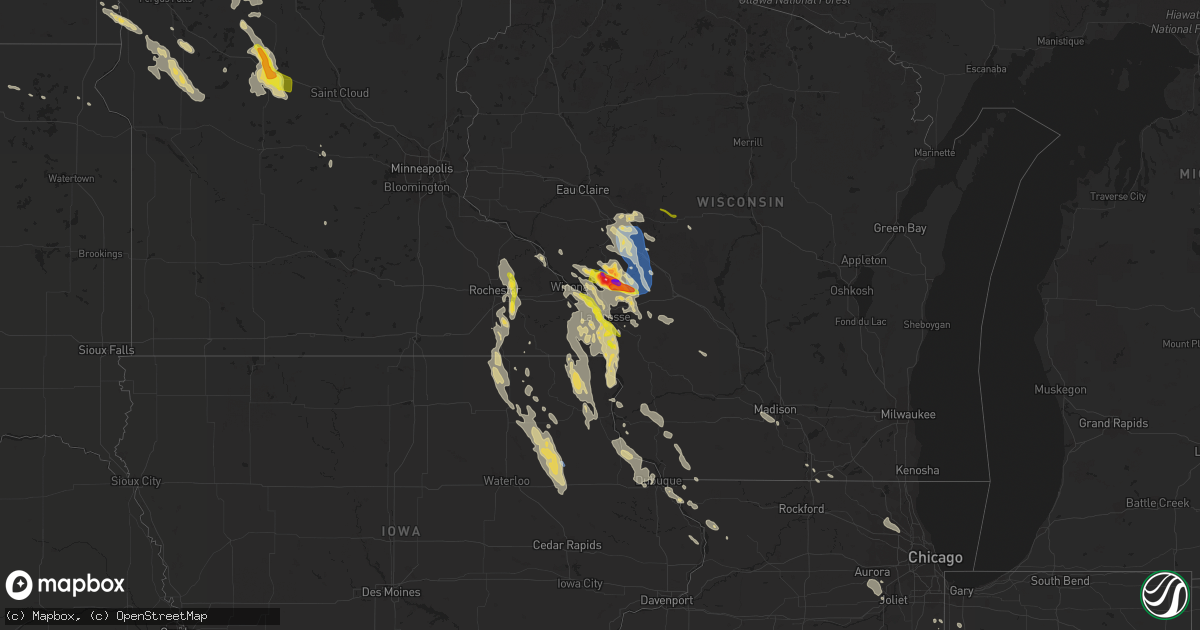
Hail Map on July 27, 2021
Get this storm
July 27 map
$229
one time, instant access
Download today. No call, no setup
Keep the $229
Bought the map and want the full workflow? Apply the entire $229 to a subscription within 7 days. None of it is wasted.
Every map, not just this one
This buys you this map. Subscription and you get every map we run, in the markets you choose from a few cities to whole states to nationwide. Plus real-time alerts the moment a storm fires.
Contact data
Name, contact info, occupancy, even credit band for addresses in the footprint. You go from where it hit to who to call.
Become the source they trust
Unlimited branding weather history reports on demand. You already have the documented answer ready for the property owner, and you are the one who showed up with it.
Property data and RoofTrace estimates
Pull up any address you have got, its value and the exact code rules for that jurisdiction, straight from One Click Code. Then RoofTrace estimates the squares, pitch, and roof value, priced the way you price.
States Impacted by Hail Map on July 27, 2021
Storm reports
New Jersey
| Date | Description |
|---|---|
| 07/27/20215:15 PM CDT | Mping report of tree limbs broken; some shingles blown off. Time estimated from radar. |
| 07/27/20215:15 PM CDT | Several tree limbs down with lane blockages along route 517 in glenwood. Time estimated from radar. |
| 07/27/20215:10 PM CDT | Tree limbs onto wires with a fire reported on armstrong road. Time estimated from radar. |
Iowa
| Date | Description |
|---|---|
| 07/27/20213:17 AM CDT | At 816 AM CDT, a severe thunderstorm was located over La Crescent, moving southeast at 30 mph. HAZARD...Quarter size hail. SOURCE...Radar indicated. IMPACT...Damage to vehicles is expected. This severe thunderstorm will be near... Brownsville around 830 AM CDT. Stoddard around 835 AM CDT.Other locations impacted by this severe thunderstorm include BrinkmanRidge, Irish Hill, North Side Of La Crosse, South Side Of La Crosse,Esofea, Goose Island and Red Mound.This includes Interstate 90 in Wisconsin between mile markers 1 and4. |
| 07/27/202112:50 AM CDT | Measured gust from public weather station. |
New Hampshire
| Date | Description |
|---|---|
| 07/27/20216:00 PM CDT | A few trees and several large branches down on esker rd and acadia ave. |
| 07/27/20215:45 PM CDT | Trees and power lines down. |
| 07/27/20215:44 PM CDT | Tree down on harvey mill road. Time estimated from radar. |
| 07/27/20215:40 PM CDT | Tree down on tuddle road. Time estimated from radar. |
| 07/27/20214:20 PM CDT | Tree down on watkins hill rd. |
| 07/27/20214:01 PM CDT | Alstead fire reported multiple tree and wires down throughout town. |
| 07/27/20214:00 PM CDT | Tree down on old settlers rd. |
| 07/27/20213:55 PM CDT | Tree down on almar st off of route 12. |
| 07/27/20213:54 PM CDT | Tree down near rt 12 near ponderosa park. |
| 07/26/202110:46 PM CDT | At 346 PM EDT, a severe thunderstorm was located over Chippenhook, moving east at 30 mph. HAZARD...60 mph wind gusts and penny size hail. SOURCE...Radar indicated. IMPACT...Expect damage to trees and powerlines. Locations impacted include... Chester, Rutland, Woodstock, Cavendish, Ludlow Village, Rutland City, Perkinsville Village, Middletown Springs, Wallingford, Mt. Holly, Rutland - Southern Vermont Airport, Plymouth, Clarendon, West Rutland, Ira, Wells, Windsor, Mount Holly, Ludlow and Andover. |
Alabama
| Date | Description |
|---|---|
| 07/27/20212:37 PM CDT | A tree fell onto a house along whitesmill road. One resident was trapped but uninjured. The house is a total loss. A few other trees were downed in the lanett area. Tim |
Wisconsin
| Date | Description |
|---|---|
| 07/27/202112:18 PM CDT | A local report indicates 1.50 inch wind near MINDORO |
| 07/27/202112:05 PM CDT | Relayed via social media with picture of tennis to baseball size hail. Lasted for about 10 minutes. |
| 07/27/20218:42 AM CDT | Report from mping. |
| 07/27/20218:40 AM CDT | Time estimated from radar. |
| 07/27/20218:35 AM CDT | Time estimated from radar. |
| 07/27/20218:06 AM CDT | A local report indicates 60 MPH wind near CATARACT |
| 07/27/20218:05 AM CDT | 1 tree down on feather avenue. Time estimated from radar. |
| 07/27/20217:55 AM CDT | 2 trees down along state highway 27. Time estimated from radar. |
| 07/27/20217:51 AM CDT | At 1251 AM CDT, severe thunderstorms were located along a line extending from 6 miles east of Menominee to near Bay Shore Park to Kaukauna, moving southeast at 55 mph. HAZARD...60 mph wind gusts. SOURCE...Radar indicated. IMPACT...Expect damage to roofs, siding, and trees. Severe thunderstorms will be near... Luxemburg around 100 AM CDT. Egg Harbor around 105 AM CDT. Kewaunee and Jacksonport around 110 AM CDT.Other locations impacted by these severe thunderstorms include Krok,Peninsula State Park, Valmy, Curran, Slovan, Gregorville, Rankin,Rock Island State Park, Carlsville and Vignes. |
| 07/27/20217:49 AM CDT | At 1248 AM CDT, a severe thunderstorm was located 8 miles southeast of Wascott, or 10 miles northwest of Hayward, moving southeast at 35 mph. HAZARD...Ping pong ball size hail and 60 mph wind gusts. SOURCE...Radar indicated. IMPACT...People and animals outdoors will be injured. Expect hail damage to roofs, siding, windows, and vehicles. Expect wind damage to roofs, siding, and trees. This severe thunderstorm will be near... Hayward and Seeley around 105 AM CDT.Other locations in the path of this severe thunderstorm include RoundLake, Little Round Lake, Chief Lake on Chippewa Flowage, ChippewaFlowage West, Chippewa Flowage East and New Post. |
| 07/27/20217:25 AM CDT | At 1224 AM CDT, a severe thunderstorm was located near Namekagon, or 18 miles northeast of Chippewa Flowage East, moving southeast at 35 mph. HAZARD...Golf ball size hail and 60 mph wind gusts. SOURCE...Radar indicated. IMPACT...People and animals outdoors will be injured. Expect hail damage to roofs, siding, windows, and vehicles. Expect wind damage to roofs, siding, and trees. This severe thunderstorm will be near... Clam Lake around 1230 AM CDT.Other locations in the path of this severe thunderstorm includeButternut. |
| 07/27/20217:12 AM CDT | A local report indicates 1.00 inch wind near GRANTON |
| 07/27/20217:00 AM CDT | At 1200 PM CDT, a severe thunderstorm was located near Galesville, or 14 miles southeast of Arcadia, moving southeast at 40 mph. HAZARD...Two inch hail and 60 mph wind gusts. SOURCE...Radar indicated. IMPACT...People and animals outdoors will be injured. Expect hail damage to roofs, siding, windows, and vehicles. Expect wind damage to roofs, siding, and trees. This severe thunderstorm will be near... North Bend around 1210 PM CDT. West Salem around 1225 PM CDT. Bangor around 1230 PM CDT.This includes Interstate 90 in Wisconsin between mile markers 9 and 20. |
| 07/27/20216:54 AM CDT | At 1154 AM CDT, a severe thunderstorm was located near Galesville, or 10 miles southeast of Arcadia, moving southeast at 40 mph. HAZARD...60 mph wind gusts and quarter size hail. SOURCE...Radar indicated. IMPACT...Hail damage to vehicles is expected. Expect wind damage to roofs, siding, and trees. This severe thunderstorm will be near... North Bend around 1210 PM CDT. West Salem around 1225 PM CDT. Bangor around 1230 PM CDT.Other locations impacted by this severe thunderstorm include CampDecorah, Stevenstown, Rockland, County Roads D E And E, SeversonCoulee, Mindoro and Newburg Corners.This includes Interstate 90 in Wisconsin between mile markers 9 and20. |
| 07/27/20213:30 AM CDT | At 830 PM CDT, a severe thunderstorm was located near Plainview, or 15 miles southwest of Wabasha, moving southeast at 10 mph. HAZARD...Quarter size hail. SOURCE...Radar indicated. IMPACT...Damage to vehicles is expected. This severe thunderstorm will be near... Elgin around 845 PM CDT. Plainview around 900 PM CDT.Other locations impacted by this severe thunderstorm include SouthTroy, Whitewater State Park, County Roads 9 And 10, RattelsnakePoint, Potsdam, County Roads 28 And 31 and Rattlesnake Ridge.This includes Interstate 90 in Minnesota between mile markers 225 and233. |
| 07/27/20212:40 AM CDT | A few trees down. Time estimated based on radar. |
| 07/27/20212:33 AM CDT | At 732 AM CDT, severe thunderstorms were located along a line extending from Shortville to 7 miles northeast of Blair, moving southeast at 40 mph. HAZARD...60 mph wind gusts. SOURCE...Radar indicated. IMPACT...Expect damage to roofs, siding, and trees. Severe thunderstorms will be near... Cataract around 810 AM CDT. Sparta and Fort Mc Coy around 820 AM CDT.Other locations impacted by these severe thunderstorms includeFranklin, Shamrock, The Black River Correctional Center, PottersFlowage, Perry Creek Recreation Area, Jellystone Park Near Warrensand The Rezin Landing Strip.This includes the following highways... Interstate 94 between mile markers 101 and 147. Interstate 90/94 between mile markers 46 and 52. Interstate 90 in Wisconsin between mile markers 21 and 45. |
| 07/26/20218:28 PM CDT | At 128 AM CDT, a severe thunderstorm was located near Willow Reservoir, or 24 miles west of Rhinelander, moving southeast at 40 mph. HAZARD...60 mph wind gusts and quarter size hail. SOURCE...Radar indicated. IMPACT...Hail damage to vehicles is expected. Expect wind damage to roofs, siding, and trees. This severe thunderstorm will remain over mainly rural areas of southwestern Oneida County, including the following locations... Gobler Lake Natural Area, Tomahawk River Pines Natural Area, Lower Tomahawk River Natural Area, Goodnow, Harshaw and Mccord. |
| 07/26/20218:27 PM CDT | At 126 AM CDT, severe thunderstorms were located along a line extending from near Chippewa Flowage East, to near Chief Lake on Chippewa Flowage, to Stone Lake, moving southeast at 45 mph. HAZARD...70 mph wind gusts and half dollar size hail. SOURCE...Radar indicated. IMPACT...Hail damage to vehicles is expected. Expect considerable tree damage. Wind damage is also likely to mobile homes, roofs, and outbuildings. Severe thunderstorms will be near... Chippewa Flowage East, Chippewa Flowage West and New Post around 130 AM CDT. Couderay around 135 AM CDT. Radisson around 140 AM CDT. Winter around 145 AM CDT. Exeland around 155 AM CDT.Other locations impacted by these severe thunderstorms includeConnors Lake, Reserve, Northwoods Beach, Chief Lake, Loretta,Sissabagama Lake, Lac Courte Oreilles Reservation, Lac CourteOreilles, Grindstone Lake and Chippewa Lake. |
Minnesota
| Date | Description |
|---|---|
| 07/27/20218:17 AM CDT | A local report indicates 1.00 inch wind near 1 W LA CRESCENT |
| 07/27/20218:17 AM CDT | A local report indicates 1.25 inch wind near LA CRESCENT |
| 07/27/20218:14 AM CDT | A local report indicates 1.00 inch wind near LA CRESCENT |
| 07/27/20216:52 AM CDT | A few large hail in very heavy rain and strong winds reported near island lake. Time estimated based on radar. |
| 07/27/20215:15 AM CDT | Mesonet station mn016 sauk centre 2se. |
| 07/27/20215:10 AM CDT | Numerous trees uprooted and a few snapped. |
| 07/27/20214:48 AM CDT | At 948 PM CDT, a severe thunderstorm was located near Chatfield, or 15 miles southeast of Rochester, moving southeast at 15 mph. HAZARD...Quarter size hail. SOURCE...Radar indicated. IMPACT...Damage to vehicles is expected. This severe thunderstorm will be near... Chatfield around 955 PM CDT. Wykoff around 1025 PM CDT. Preston and Fountain around 1030 PM CDT.Other locations impacted by this severe thunderstorm include CountyRoads 2 And 38, Forestville State Park, Carimona, Fillmore, CountyRoads 2 And 101, Cummingsville and Washington. |
| 07/27/20214:16 AM CDT | At 915 AM CDT, a severe thunderstorm was located 9 miles east of New Albin, or 11 miles west of Viroqua, moving south at 40 mph. HAZARD...Quarter size hail. SOURCE...Radar indicated. IMPACT...Damage to vehicles is expected. This severe thunderstorm will remain over mainly rural areas of southwestern Vernon and Crawford Counties, including the following locations... Eastman, Red Mound, Rush Creek, Harris Ridge, Fairview, Bud and Maple Ridge. |
| 07/27/20214:16 AM CDT | At 915 PM CDT, a severe thunderstorm was located over Eyota, or 11 miles east of Rochester, moving southeast at 20 mph. HAZARD...60 mph wind gusts and quarter size hail. SOURCE...Public. Quarter sized hail was reported north of Eyota. IMPACT...Hail damage to vehicles is expected. Expect wind damage to roofs, siding, and trees. This severe thunderstorm will be near... Eyota around 920 PM CDT. Dover around 930 PM CDT. St. Charles around 935 PM CDT. Chatfield around 945 PM CDT.Other locations impacted by this severe thunderstorm include Chester,Ringe, Saratoga, County Roads 9 And 10, County Roads 137 And 136,Highway 30 And County 74 and Viola.This includes Interstate 90 in Minnesota between mile markers 220 and238. |
| 07/26/202110:05 PM CDT | Wind gust from a home weather station northwest of wykoff. |
| 07/26/20219:10 PM CDT | Public report via twitter and kaal tv. |
North Dakota
| Date | Description |
|---|---|
| 07/27/20213:50 AM CDT | Large wind driven hail damaged fields across portions of western and central colfax township before 4am cdt. |
| 07/27/20213:40 AM CDT | A few big branches... Dead trees blown down. |
| 07/27/20212:40 AM CDT | A few big branches... Dead trees down. |
Florida
| Date | Description |
|---|---|
| 07/27/20213:45 AM CDT | At 845 PM EDT, a severe thunderstorm was located near I-75 At Exit 16, or 10 miles west of Lake Park, moving east at 30 mph. HAZARD...60 mph wind gusts and penny size hail. SOURCE...Radar indicated. IMPACT...Expect damage to roofs, siding, and trees. Locations impacted include... Lake Park, Valdosta, I-75 At Exit 16, Dasher, I-75 At Exit 5, Twin Lakes, Clyattville, I-75 At Exit 11, Valdosta Regional Airport, Kinderlou and Blue Springs. |
Maine
| Date | Description |
|---|---|
| 07/27/20211:36 AM CDT | At 636 PM EDT, severe thunderstorms were located along a line extending from near Northwood to near York, moving east at 30 mph. HAZARD...60 mph wind gusts and penny size hail. SOURCE...Radar indicated. IMPACT...Expect damage to roofs, siding, and trees. Locations impacted include... Portsmouth, Durham, Exeter, Kittery, Dover, Barrington, Epping, Brentwood, Greenland, York, Newington, Stratham, Newmarket, Rye, South Berwick, Eliot, Lee, Fremont, Madbury and Nottingham.This includes the following highways... Interstate 95 between mile markers 1 and 11. Interstate 95 in New Hampshire between mile markers 10 and 16.This also includes... York Beach. |
Massachusetts
| Date | Description |
|---|---|
| 07/27/20216:59 PM CDT | Tree down on wires on north truro rd in hingham |
| 07/27/20216:40 PM CDT | Tree down blocking road on furnace brook pkwy in quincy. Relayed by amateur radio. |
| 07/27/20216:40 PM CDT | Tree down on car on evans and west squantum streets... Person trapped and extricated... Uninjured. Relayed by amateur radio. |
| 07/27/20216:40 PM CDT | Tree down on 49 nelson st in quincy. Relayed by amateur radio |
| 07/27/20216:36 PM CDT | Tree down on englewood ave in brighton. Relayed by amateur radio. |
| 07/27/20216:35 PM CDT | A local report indicates 61 MPH wind near LOGAN AP |
| 07/27/20216:34 PM CDT | Tree down in the roadway on crushing street. Tree down on car on clinton street. Tree down on carberry street. Tree and wires down and leaning on a house on governors a |
| 07/27/20216:30 PM CDT | Tree down on house in the area of 101 pearl street. Small tree down on car on bonair street. Relayed by amateur radio. |
| 07/27/20216:27 PM CDT | Tree down near the channel 7 news station on bullfinch place. |
| 07/27/20216:27 PM CDT | Tree down on fresh pond parkway. Tree down and blocking antrim street. Relayed by amateur radio. |
| 07/27/20216:27 PM CDT | Tree down on haven st and church st intesection in dover. Relayed by amateur radio. |
| 07/27/20216:27 PM CDT | Power lines down on cummings road. Relayed by amateur radio. |
| 07/27/20216:27 PM CDT | Power lines down on wales street. Relayed by amateur radio. |
| 07/27/20216:27 PM CDT | Tree down on a car on everett st |
| 07/27/20216:27 PM CDT | Tree down across cricuit drive; power lines down on neponset valley parkway... Two trees down on 400 block of marlboro street... Large branch down on car on 1300 block |
| 07/27/20216:27 PM CDT | Large branch down on lower south street next to arnold street. Relayed by amateur radio. |
| 07/27/20216:27 PM CDT | Tree down on adams street at wiltshire road. Relayed by amateur radio. |
| 07/27/20216:26 PM CDT | Branches down on the mass pike |
| 07/27/20216:26 PM CDT | Tree and wires down at 33 brown street. Relayed by amateur radio. |
| 07/27/20216:21 PM CDT | Tree down on a car on commonwealth ave in newton |
| 07/27/20216:21 PM CDT | Tree down blocking the street near 19 park drive. Tree down on a house at 111 prospect street. Relayed by amateur radio. |
| 07/27/20216:19 PM CDT | Tree down on south main street at bullard road. Rleayed by amateur radio. |
| 07/27/20216:18 PM CDT | Large branch down near 33 cedar street. Relayed by amateur radio. |
| 07/27/20216:10 PM CDT | Tree down on a house at 88 kendall lane. Relayed by amateur radio. |
| 07/27/20216:00 PM CDT | Tree down near 8 north main street. Relayed by amateur radio. |
| 07/27/20215:55 PM CDT | Tree and wires down at 7 arch street. Relayed by amateur radio. |
| 07/27/20215:48 PM CDT | Siding blown off the side of a house on brigham streeet near south street. Relayed by amateur radio. |
| 07/27/20215:45 PM CDT | Tree down partially blocking road at 1222 pleasant street. Relayed by amateur radio. |
| 07/27/20215:40 PM CDT | Large tree downed on main and mill st in boylston. |
| 07/27/20215:40 PM CDT | Two trees down on hillando drive near walnut street. Relayed by amateur radio. |
| 07/27/20215:40 PM CDT | 4-5 foot diameter tree down at corner of main street and paul tivman road. Large branch down at the corner of belair street and main street. |
| 07/27/20215:38 PM CDT | Tree down on top of a car. Wires down. Relayed by amateur radio. |
| 07/27/20215:38 PM CDT | Tree down on a car at 61 briar lane. Power lines down on tacoma street and clark street. Tree and wires down blocking road on quinapoxet lane near bergstrom road. Relay |
| 07/27/20215:33 PM CDT | Tree down on wires between 73 and 95 mccormick road. Relayed by amateur radio. |
| 07/27/20215:32 PM CDT | A local report indicates 65 MPH wind near HOLDEN |
| 07/27/20215:31 PM CDT | Tree down blocking west road near padre road. Relayed by amateur radio. |
| 07/27/20215:28 PM CDT | Utility pole down on route 20 at dewey street. Tree down on wires birnie ave. |
| 07/27/20215:28 PM CDT | Wires down near 1004 north west street. |
| 07/27/20215:25 PM CDT | Tree downed across route 8 |
| 07/27/20215:23 PM CDT | Tree down blocking west road near padre road. Relayed by amateur radio. |
| 07/27/20215:20 PM CDT | A local report indicates 60 MPH wind near HOLDEN |
| 07/27/20215:15 PM CDT | Tree and wires down behind a home at 750 williamsville road. Relayed by amateur radio. |
| 07/27/20215:13 PM CDT | Tree down near 185 huntington road |
| 07/27/20215:06 PM CDT | Tree down on wires near 46 bray road. Relayed by amateur radio. |
| 07/27/20214:46 PM CDT | Wires down on amherst road near enfield road. Relayed by amateur radio. |
| 07/27/20214:45 PM CDT | Tree branches down on south whitney street by college street... And also on east pleasant street by owen drive. Wires down on 34 baker street. Relayed by amateur radio. |
| 07/27/20214:40 PM CDT | Tree down at 90 lindseed road. Tree down on arnold road. Relayed by amateur radio. |
| 07/27/20214:39 PM CDT | Tree down on wires. Relayed by amateur radio. |
| 07/27/20214:31 PM CDT | Tree down on lower road. Relayed by amateur radio. |
| 07/27/20214:31 PM CDT | Tree in down on haydenville road by westbrook road. Tree down on i-91 south. Relayed by amateur radio. |
| 07/27/20214:28 PM CDT | Trees downed on a house on new lenox road |
| 07/27/20214:27 PM CDT | Tree and wires downed on a house on east street |
| 07/27/20214:26 PM CDT | Wires downed at the corner of housatonic street and high street |
| 07/27/20214:24 PM CDT | Tree downed on circular avenue |
| 07/27/20214:23 PM CDT | Tree down on route 9. Tree down on berkshire trail. Relayed by amateur radio. |
| 07/27/20214:20 PM CDT | Trees and wires down on plainfield road |
| 07/27/20214:18 PM CDT | Wires down on main street |
| 07/27/20213:50 PM CDT | Tree downed across route 8 |
| 07/27/20213:50 PM CDT | Tree downed |
| 07/27/20213:47 PM CDT | Wires downed on bridge street |
| 07/27/20213:47 PM CDT | Tree downed on balance road road |
| 07/27/20211:33 AM CDT | At 632 PM EDT, severe thunderstorms were located along a line extending from near Fitchburg to Leicester, moving east at 40 mph. HAZARD...60 mph wind gusts and nickel size hail. SOURCE...Radar indicated. IMPACT...Expect damage to trees and power lines. Locations impacted include... Boston, Worcester, Cambridge, Brockton, Quincy, Newton, Somerville, Framingham, Waltham, Malden, Brookline, Medford, Weymouth, Revere, Arlington, Everett, Leominster, Fitchburg, Billerica and Marlborough. |
| 07/27/202112:04 AM CDT | At 503 PM EDT, a severe thunderstorm was located over East Windsor, or 15 miles east of Pittsfield, moving southeast at 40 mph. HAZARD...60 mph wind gusts and quarter size hail. SOURCE...Radar indicated. This storm has downed trees in portions of central Berkshire County. IMPACT...Expect wind damage to trees and power lines. Minor hail damage to vehicles is possible. Locations impacted include... Springfield, Chicopee, Holyoke, Amherst, Northampton, Deerfield, Ludlow, South Hadley, Easthampton, Belchertown, Wilbraham, Ware, Montague, Granby, Southampton, Hadley, Sunderland, Hatfield, Williamsburg and Huntington. |
| 07/26/202111:30 PM CDT | At 429 PM EDT, severe thunderstorms were located along a line extending from near Pownal to near Hancock to near Stephentown, moving east at 25 mph. HAZARD...60 mph wind gusts and nickel size hail. SOURCE...Radar indicated. IMPACT...Expect damage to roofs, siding, and trees. Locations impacted include... Pittsfield, North Adams, Adams, Williamstown, Cheshire, Stephentown, Florida, Hancock, Savoy, New Ashford, Berkshire, Dalton, Lanesborough, Hinsdale, Windsor, Peru, East Nassau, Hairpin Turn, Barkerville and Greylock. |
New York
| Date | Description |
|---|---|
| 07/27/20214:10 PM CDT | Tree and wires down. Time estimated by radar. |
| 07/27/20214:10 PM CDT | Trees down from thunderstorm outflow boundary. Time estimated from radar. |
| 07/27/20214:00 PM CDT | Trees down from thunderstorm outflow boundary. |
| 07/27/20213:57 PM CDT | Corrects previous tstm wnd dmg report from 2 w callicoon. Tree and wires down. Time estimated by radar. |
| 07/27/20213:54 PM CDT | Tree and wires down. Time estimated by radar. |
| 07/27/20213:52 PM CDT | Tree and wires down. Time estimated by radar. |
| 07/27/20213:52 PM CDT | Corrects previous tstm wnd dmg report from 3 ne fremont. Multiple reports of trees and wires down along rt 93 in the crystal lake wild forest area. Rt 93 is blocked. Ti |
| 07/27/20213:41 PM CDT | Power pole snapped on broadway |
| 07/27/20213:10 PM CDT | Couple trees down schoharie hill road. Time estimated by radar. |
| 07/27/20213:10 PM CDT | Couple trees on eminence road. Time estimated by radar. |
| 07/27/20213:00 PM CDT | Tree down on house. Time estimated by radar. |
| 07/27/20212:59 PM CDT | Large tree limb downed on howard street |
| 07/27/20212:59 PM CDT | Power pole snapped on broadway |
| 07/27/20212:52 PM CDT | Tree downed on englemore road |
| 07/27/20212:45 PM CDT | Tree down on road. Time estimated by radar. |
| 07/27/20212:45 PM CDT | Tree down. Time estimated by radar. |
| 07/27/20212:45 PM CDT | Strong thunderstorm winds knocked down a tree on a porch. |
| 07/27/20212:44 PM CDT | Tree and wires downed across kennedy lane |
| 07/27/20212:40 PM CDT | Wires downed on riverview drive in rexford |
| 07/27/20212:35 PM CDT | Strong thunderstorm winds broke large tree limbs and also broke utility poles. |
| 07/27/20212:30 PM CDT | Tree and wires down on a house. Time estimated by radar. |
| 07/27/20212:20 PM CDT | Tree and wires down on road. Time estimated by radar. |
| 07/27/20212:03 PM CDT | Corrects previous tstm wnd dmg report from whitney point. Strong thunderstorm winds knocked down wires. Correcting that media source confirmed that the fair grounds wer |
| 07/27/20212:02 PM CDT | Tree down on road near tinker falls. |
| 07/27/20212:00 PM CDT | Two trees down in ft. Hunter near the intersection of main st. And schoharie st. |
| 07/27/20212:00 PM CDT | Large branches down on many properties along mohawk drive. |
| 07/27/20211:53 PM CDT | Tree down on wires at 2972 route 30a |
| 07/27/20211:51 PM CDT | Trees and wires downed on route 30a between route 5 in fonda and chestnut street in johnstown |
| 07/27/20211:47 PM CDT | Strong thunderstorm winds knocked down utility poles and wires down on road. |
| 07/27/20211:42 PM CDT | Strong thunderstorm winds knocked down a tree and wires in front of entry way of a residence. |
| 07/27/20211:25 PM CDT | A local report indicates 59 MPH wind near HARTSVILLE |
| 07/27/20211:19 PM CDT | Corrects previous tstm wnd dmg report from 2 sw pulteney |
| 07/27/20211:07 AM CDT | At 607 PM EDT, a severe thunderstorm was located near Unionville, or 9 miles southeast of Matamoras, moving east at 25 mph. HAZARD...60 mph wind gusts and penny size hail. SOURCE...Radar indicated. IMPACT...Damage to roofs, siding, trees, and power lines is possible. Locations impacted include... Hamburg, Sussex, Vernon Valley, High Point and Highland Lake. |
| 07/27/202112:19 AM CDT | At 519 PM EDT, a severe thunderstorm was located near Lenox, or near Pittsfield, moving east at 35 mph. HAZARD...60 mph wind gusts. SOURCE...Radar indicated. IMPACT...Expect damage to roofs, siding, and trees. Locations impacted include... Pittsfield, Lee, Lenox, Becket, Otis, Hinsdale, Stockbridge, Richmond, West Stockbridge, Washington, Tyringham, Barkerville, Mahkeenac Heights, North Otis, Glendale, Tanglewood, New Lenox, Lenox Dale, The Center At Lenox and Adams Junction. |
| 07/27/202112:09 AM CDT | At 509 PM EDT, a severe thunderstorm was located over Liberty, moving east at 45 mph. HAZARD...60 mph wind gusts. SOURCE...Radar indicated. IMPACT...Expect damage to roofs, siding, and trees. Locations impacted include... Fallsburg, Monticello, Liberty, Bethel, Neversink, South Fallsburg, Wurtsboro, Woodridge, Bloomingburg and Jeffersonville. |
| 07/26/202111:34 PM CDT | At 433 PM EDT, a severe thunderstorm was located over Livingstonville, or 16 miles southeast of Cobleskill, moving east at 50 mph. HAZARD...60 mph wind gusts. SOURCE...Radar indicated. IMPACT...Expect damage to roofs, siding, and trees. Locations impacted include... New Baltimore, Westerlo, Ravena, Coxsackie, Middleburgh, Livingstonville, Preston-Potter Hollow, Preston Hollow, Selkirk, Coeymans, Rensselaerville, Coeymans Hollow, Huntersland, Spawn Hollow, Dormansville. |
| 07/26/202110:51 PM CDT | At 349 PM EDT, severe thunderstorms were located along a line extending from near Harpursville to near Rome, moving southeast at 35 mph. HAZARD...60 mph wind gusts. SOURCE...Law enforcement. IMPACT...Expect damage to roofs, siding, and trees. Locations impacted include... Kirkwood, Conklin, Rush, Jackson, Clifford, Sanford, Susquehanna, Deposit, Susquehanna Depot and Springville. |
| 07/26/202110:20 PM CDT | At 319 PM EDT, a severe thunderstorm was located over West Winfield, or 10 miles southwest of Ilion, moving east at 30 mph. HAZARD...60 mph wind gusts. SOURCE...Radar indicated. IMPACT...Expect damage to roofs, siding, and trees. Locations impacted include... Ilion, West Winfield, Jordanville, Elizabethtown, Jersalem Hill, Spinnerville, Cedar Lake, Chepachet, Columbia Center, Dennison Corners, Smith Corners, Schuyler Corners and Van Hornesville. |
| 07/26/20219:51 PM CDT | At 250 PM EDT, a severe thunderstorm was located over Tribes Hill, or over Fonda, moving east at 30 mph. HAZARD...60 mph wind gusts and quarter size hail. SOURCE...Radar indicated. IMPACT...Hail damage to vehicles is expected. Expect wind damage to roofs, siding, and trees. Locations impacted include... Schenectady, Rotterdam, Amsterdam, Gloversville, Johnstown, Scotia, Fonda, Glenville, Niskayuna, Ballston Spa, Hagaman, Fort Johnson, Galway, Rotterdam Junction, East Glenville, Burnt Hills, Tribes Hill, North Ballston Spa, Alplaus and Pattersonville-Rotterdam Junction. |
| 07/26/20219:29 PM CDT | At 228 PM EDT, severe thunderstorms were located along a line extending from Kirkville to La Fayette to Kelloggsville, moving east at 45 mph. HAZARD...60 mph wind gusts. IMPACT...Expect damage to roofs, siding, and trees. Locations impacted include... Sullivan, Oneida, Lenox, Norwich, Pompey, Eaton, Chittenango, Canastota, Manlius and Paris. |
| 07/26/20219:23 PM CDT | At 221 PM EDT, a severe thunderstorm was located over Tyrone, or 9 miles southwest of Dundee, moving southeast at 30 mph. HAZARD...60 mph wind gusts and penny size hail. SOURCE...Law enforcement. A tree was reported on a residence in Pulteney. IMPACT...Expect damage to roofs, siding, and trees. Locations impacted include... Newfield, Danby, Erin, Watkins Glen, Catharine, Montour Falls, Tyrone, Wayne, Bradford and Spencer. |
Georgia
| Date | Description |
|---|---|
| 07/27/20215:10 PM CDT | Tree down on a car in buckhead. No injuries reported. |
| 07/27/20215:00 PM CDT | Multiple trees reported down along broadland rd nw... Between andover rd and w conway dr nw. |
| 07/27/20214:54 PM CDT | Tree down near intersection of miller rd and thompson mill rd |
| 07/27/20214:45 PM CDT | Tree down near the intersection of w farington rd and panola rd |
| 07/27/20214:45 PM CDT | Tree down near the intersection of oaktree trail and panola rd |
| 07/27/20214:18 PM CDT | Reported via mping near the intersection of tividale ct and hebden bridge ln. |
| 07/27/20214:07 PM CDT | Multiple trees down. |
| 07/27/20213:35 PM CDT | 3 trees down along porter rd. |
| 07/27/20213:30 PM CDT | Tree down along 13th street in columbus. |
| 07/27/202112:58 AM CDT | At 558 PM EDT, a severe thunderstorm was located over Chastain Memorial Park, or 7 miles northwest of Decatur, moving south at 10 mph. HAZARD...60 mph wind gusts and quarter size hail. SOURCE...Radar indicated. IMPACT...Hail damage to vehicles is expected. Expect wind damage to roofs, siding, and trees. Locations impacted include... Atlanta, Decatur, Sandy Springs, Dunwoody, Chamblee, Grant Park-Zoo Atlanta, North Decatur, North Atlanta, North Druid Hills, Druid Hills, Midtown, Virginia Highland, Sweet Auburn, Piedmont Park, Brookhaven, Bolton, La Vista, Little Five Points, Atlantic Station and Chastain Memorial Park. |
| 07/27/202112:11 AM CDT | At 511 PM EDT, a severe thunderstorm was located near Johns Creek, or 12 miles southwest of Cumming, moving south at 10 mph. HAZARD...60 mph wind gusts and quarter size hail. SOURCE...Radar indicated. IMPACT...Hail damage to vehicles is expected. Expect wind damage to roofs, siding, and trees. Locations impacted include... Sandy Springs, Roswell, Johns Creek, Alpharetta, Dunwoody, Duluth, Norcross, Doraville, Berkeley Lake, Mechanicsville and Brookwood. |
Texas
| Date | Description |
|---|---|
| 07/27/20216:35 PM CDT | Tree damage reported in haltom city. Also reported very heavy rain and sudden wind changes as storm passed. |
| 07/27/20215:44 PM CDT | Home damage was reported in lake bridgeport. |
| 07/27/20215:40 PM CDT | Roof blown off homes in lake bridgeport. |
| 07/27/20215:26 PM CDT | 60 mph wind gust with tree damage and power outages in bridgeport. |
| 07/27/20214:55 PM CDT | 76 mph wind gust reported by the decatur municipal airport awos. |
| 07/27/20214:00 PM CDT | Sunset post office roof damaged. |
| 07/27/20211:49 AM CDT | At 648 PM CDT, a severe thunderstorm was located over White Settlement, and another severe thunderstorm over Annette South. These storms are moving southwest at 10 mph. HAZARD...60 mph wind gusts. SOURCE...Radar indicated. IMPACT...Expect damage to roofs, siding, and trees. Locations impacted include... Fort Worth, Benbrook, White Settlement, River Oaks, Sansom Park, Lake Worth, Willow Park, Aledo, Westworth Village, Annetta, Westover Hills, Annetta South, and Annetta North. |
| 07/27/20211:40 AM CDT | At 640 PM CDT, a severe thunderstorm was located near Campbell, or near Commerce, moving southwest at 10 mph. HAZARD...60 mph wind gusts. SOURCE...Radar indicated. IMPACT...Expect damage to roofs, siding, and trees. Locations impacted include... Greenville, Commerce, Caddo Mills, Campbell, Lone Oak, and Neylandville.This includes Interstate 30 between mile markers 87 and 109. |
| 07/27/20211:31 AM CDT | At 631 PM CDT, a severe thunderstorm was located over Haltom City, moving west at 10 mph. HAZARD...60 mph wind gusts. SOURCE...Radar indicated. IMPACT...Expect damage to roofs, siding, and trees. Locations impacted include... Fort Worth, Arlington, Euless, Bedford, Haltom City, Keller, Hurst, Watauga, Colleyville, Saginaw, Forest Hill, Richland Hills, River Oaks, Sansom Park, Lake Worth, Eagle Mountain, North Richland Hills, Edgecliff Village, and Blue Mound. |
| 07/27/20211:19 AM CDT | At 619 PM CDT, a severe thunderstorm was located near Zwolle, or 29 miles south of Mansfield, moving southwest at 15 mph. HAZARD...60 mph wind gusts. SOURCE...Radar indicated. IMPACT...Expect damage to roofs, siding, and trees. Locations impacted include... Many, Zwolle and Negreet. |
| 07/27/20211:14 AM CDT | At 613 PM CDT, a severe thunderstorm was located over Springtown, or 7 miles west of Briar, and is nearly stationary. HAZARD...70 mph wind gusts. SOURCE...Radar indicated. IMPACT...Expect considerable tree damage. Damage is likely to mobile homes, roofs, and outbuildings. Locations impacted include... Briar, Reno, Springtown, and Poolville. |
| 07/27/202112:57 AM CDT | At 556 PM CDT, a severe thunderstorm was located near Bridgeport, moving south at 5 mph. HAZARD...60 mph wind gusts. SOURCE...Radar indicated. IMPACT...Expect damage to roofs, siding, and trees. Locations impacted include... Bridgeport, Briar, Paradise, Boonsville, Cottondale, Runaway Bay and Lake Bridgeport. |
| 07/27/202112:38 AM CDT | At 537 PM CDT, severe thunderstorms were located along a line extending from Bridgeport to Graford, moving southwest at 5 mph. HAZARD...65 mph wind gusts. SOURCE...Radar indicated. IMPACT...Expect damage to roofs, siding, and trees. Locations impacted include... Bridgeport, Graford, Poolville, Boonsville, Runaway Bay and Lake Bridgeport. |
| 07/27/202112:02 AM CDT | At 501 PM CDT, a severe thunderstorm was located over Decatur, moving southwest at 5 mph. HAZARD...60 mph wind gusts. SOURCE...Radar indicated. IMPACT...Expect damage to roofs, siding, and trees. Locations impacted include... Decatur, Bridgeport, Alvord, New Fairview, Boyd, Chico, Paradise, Cottondale, and Lake Bridgeport. |
| 07/26/20217:00 PM CDT | Trained spotter estimated 60 mph winds along with heavy rain and minor flooding. |
Rhode Island
| Date | Description |
|---|---|
| 07/27/20216:45 PM CDT | Top third of large pine tree snapped off at the 30 block of rhode island ave. Top of tree caused damage to a work van... Boat... And fence. Smaller limbs landed on the |
| 07/27/20216:40 PM CDT | Diamond hill road and nate whipple highway... Tree down and blocking half the road. Report relayed by amateur radio. |
| 07/27/20216:25 PM CDT | Tree down on a car near 1720 victory highway in burrillville. Relayed by amateur radio. |
| 07/27/20212:26 AM CDT | At 725 PM EDT, severe thunderstorms were located along a line extending from Rowley to Woonsocket, moving southeast at 30 mph. HAZARD...60 mph wind gusts and nickel size hail. SOURCE...Radar indicated. These storms have a history of producing downed trees and powerlines in Worcester, Wellesley and Westborough. IMPACT...Expect damage to trees and power lines. Locations impacted include... Boston, Cambridge, Brockton, Quincy, Lynn, Newton, Somerville, Waltham, Malden, Brookline, Medford, Taunton, Weymouth, Revere, Peabody, Arlington, Everett, Salem, Woonsocket and Beverly. |
Pennsylvania
| Date | Description |
|---|---|
| 07/27/20216:16 PM CDT | Corrects time of previous tstm wnd dmg report from mountain top. Trees and wires down in mountain top. Radar estimated time. |
| 07/27/20216:10 PM CDT | Tree down blocking thomas road. Via county dispatch feed. |
| 07/27/20216:09 PM CDT | Tree and wires down. Rice township. Via county dispatch feed. Radar estimated time. |
| 07/27/20216:05 PM CDT | Large branch down on vehicle. Radar estimated time. |
| 07/27/20216:05 PM CDT | Tree down on home. Plymouth township. Via county dispatch feed. Radar estimated time. |
| 07/27/20215:55 PM CDT | Trees and wires down in dallas area. Radar estimated time. |
| 07/27/20215:35 PM CDT | Trees and wires down. Fairmount township up on the way towards ricketts glen. Radar estimated time. |
| 07/27/20214:55 PM CDT | Outflow winds downed wires on s courtland st. Time estimated from radar. |
| 07/27/20214:45 PM CDT | Outflow winds downed wires at oak ln and locust ln. Time estimated from radar. |
| 07/27/20214:32 PM CDT | A few trees down in gouldsboro area... Near borders of lehigh township and clifton township. Radar estimated time. |
| 07/27/20214:31 PM CDT | Strong thunderstorm winds knocked down tree on roadway. |
| 07/27/20214:10 PM CDT | A single large tree down in scranton. Radar estimated time. |
| 07/27/20213:52 PM CDT | Strong thunderstorm winds from an outflow boundary knocked a tree down on roadway. |
| 07/27/20213:39 PM CDT | Strong winds from an outflow boundary knocked down a tree. |
| 07/27/20213:31 PM CDT | Strong winds from an outflow boundary knocked down a tree on roadway. |
| 07/27/20213:25 PM CDT | Tree plus wires down on a car. Via county dispatch feed. Radar estimated time. |
| 07/27/20213:21 PM CDT | Strong winds from outflow boundary knocked down tree blocking roadway. |
| 07/27/20213:18 PM CDT | Strong winds from outflow boundary knocked down tree onto wires. |
| 07/27/20213:16 PM CDT | Strong thunderstorm winds knocked down a tree on roadway. |
| 07/27/20213:13 PM CDT | Strong thunderstorm winds knocked down tree blocking partial roadway. |
| 07/27/20213:10 PM CDT | Tree down blocking part of route 220. Via county dispatch feed. Radar estimated time. |
| 07/27/20212:50 PM CDT | Strong thunderstorm winds knocked down a tree and wires down on leona rd. |
| 07/27/20212:50 PM CDT | Strong thunderstorm winds knocked down tree on lines. |
| 07/27/20212:22 AM CDT | At 722 PM EDT, a severe thunderstorm was located over Bear Creek, or near Wilkes-Barre, moving southeast at 35 mph. HAZARD...60 mph wind gusts. SOURCE...Radar indicated. IMPACT...Damage to roofs, siding, trees, and power lines is possible. Locations impacted include... Mount Pocono, Tobyhanna, Pocono Pines, Pocono Raceway, Lake Harmony, Mountainhome, Canadensis, Blakeslee, Long Pond, Albrightsville, Gouldsboro State Park, Sun Valley, Arrowhead Lake, Jonas, Meckesville, Paradise Valley, Cresco and Merwinsburg.This includes the following highways... Northeast Extension between mile markers 87 and 97. Interstate 80 in Pennsylvania between mile markers 277 and 300. Interstate 380 in Pennsylvania between mile markers 0 and 13. |
| 07/27/20212:12 AM CDT | At 711 PM EDT, a severe thunderstorm was located over Wilkes-Barre, moving southeast at 35 mph. HAZARD...60 mph wind gusts and quarter size hail. SOURCE...Radar indicated. IMPACT...Hail damage to vehicles is expected. Expect wind damage to roofs, siding, and trees. Locations impacted include... Wilkes-Barre, Kingston, Nanticoke, Plains, Pittston, Plymouth, Exeter, Swoyersville, West Pittston and Edwardsville. |
| 07/27/20211:26 AM CDT | At 625 PM EDT, a severe thunderstorm was located near Ricketts Glen State Park, or 18 miles south of Wyalusing, moving southeast at 25 mph. HAZARD...60 mph wind gusts and quarter size hail. SOURCE...Radar indicated. IMPACT...Hail damage to vehicles is expected. Expect wind damage to roofs, siding, and trees. Locations impacted include... Wilkes-Barre, Muhlenberg, Kingston, Nanticoke, Plymouth, Exeter, Vernon, Swoyersville, Edwardsville and Larksville. |
| 07/27/202112:38 AM CDT | At 537 PM EDT, a severe thunderstorm was located over Sterling, or 14 miles north of Mount Pocono, moving southeast at 40 mph. HAZARD...60 mph wind gusts and penny size hail. SOURCE...Radar indicated. IMPACT...Damage to roofs, siding, trees, and power lines is possible. Locations impacted include... Newton, Mount Pocono, Tobyhanna, Blairstown, Branchville, Flatbrookville, Henryville, Werry Lake, Millbrook, Skytop, Mountainhome, Canadensis, Alpine Mountain, Five Points, Pellettown, Crandon Lakes, Echo Lake, Paradise Valley, Gouldsboro State Park and Hainesville.This includes the following highways... Interstate 80 in New Jersey between mile markers 14 and 16. Interstate 380 in Pennsylvania between mile markers 8 and 12. |
| 07/27/202112:14 AM CDT | At 513 PM EDT, a severe thunderstorm was located over Clarks Green, or over Waverly, moving east at 45 mph. However, gusts from the storm were pushing out well out in front of it. HAZARD...60 mph wind gusts. SOURCE...Radar indicated. This storm also has a history of downed trees. IMPACT...Expect damage to roofs, siding, and trees. Locations impacted include... Scranton, Dunmore, Carbondale, Old Forge, Archbald, Blakely, Taylor, Dickson City, Moosic and Olyphant. |
| 07/26/202111:22 PM CDT | At 421 PM EDT, severe thunderstorms were located along a line extending from Hancock to near Overton, moving east at 40 mph. HAZARD...60 mph wind gusts. SOURCE...Law enforcement. IMPACT...Expect damage to roofs, siding, and trees. Locations impacted include... Scranton, Falls, Dunmore, Fallsburg, Carbondale, Old Forge, Pittston, Archbald, Monticello and Blakely. |
| 07/26/202111:03 PM CDT | At 403 PM EDT, severe thunderstorms were located along a line extending from Wysox to Canton, moving southeast at 25 mph. HAZARD...60 mph wind gusts. SOURCE...Radar indicated. IMPACT...Expect damage to roofs, siding, and trees. Locations impacted include... Towanda, Canton, West Franklin, Wysox, Troy, Wilmot, Hollenback, North Towanda, West Burlington and Wyalusing. |
| 07/26/20219:56 PM CDT | At 255 PM EDT, severe thunderstorms were located along a line extending from near Willet to Candor, moving southeast at 20 mph. HAZARD...60 mph wind gusts. SOURCE...Radar indicated. IMPACT...Expect damage to roofs, siding, and trees. Locations impacted include... Binghamton, Vestal, Johnson City, Endicott, Kirkwood, Conklin, Maine, Owego, Sanford and Nanticoke. |
| 07/26/20217:16 PM CDT | Trees and wires down in mountain top. Radar estimated time. |
Virginia
| Date | Description |
|---|---|
| 07/27/20216:51 AM CDT | At 1151 PM EDT, a severe thunderstorm was located near Goode, or near Bedford, moving east at 5 mph. HAZARD...60 mph wind gusts and quarter size hail. SOURCE...Radar indicated. IMPACT...Hail damage to vehicles is expected. Expect wind damage to roofs, siding, and trees. Locations impacted include... Bedford... Forest... Big Island... Coleman Falls... Boonsboro... Goode... and Sedalia. |
| 07/27/20216:50 AM CDT | At 1150 PM EDT, a severe thunderstorm was located near Lowesville, or 7 miles northeast of Forks Of Buffalo, moving southeast at 15 mph. HAZARD...60 mph wind gusts and quarter size hail. SOURCE...Radar indicated. IMPACT...Hail damage to vehicles is expected. Expect wind damage to roofs, siding, and trees. Locations impacted include... Clifford... Lowesville... and New Glasgow. |
| 07/27/20216:33 AM CDT | At 1133 PM EDT, a severe thunderstorm was located over Montebello, or 11 miles north of Forks Of Buffalo, moving northeast at 20 mph. HAZARD...60 mph wind gusts and quarter size hail. SOURCE...Radar indicated. IMPACT...Damaging winds will cause some trees and large branches to fall. This could injure those outdoors, as well as damage homes and vehicles. Roadways may become blocked by downed trees. Localized power outages are possible. Unsecured light objects may become projectiles. Locations impacted include... Shipman, Schuyler, Wintergreen, Montebello, Afton, Nellysford, Arrington, Lovingston, Bryant, Tye River, Roseland, Tyro, Rockfish, Buffalo Springs, Greenfield, Norwood, Jonesboro, Elma, Faber and Massies Mill. |
| 07/27/20216:24 AM CDT | At 1124 PM EDT, a severe thunderstorm was located near Afton, or 7 miles southeast of Waynesboro, moving southeast at 15 mph. HAZARD...60 mph wind gusts and quarter size hail. SOURCE...Radar indicated. IMPACT...Damaging winds will cause some trees and large branches to fall. This could injure those outdoors, as well as damage homes and vehicles. Roadways may become blocked by downed trees. Localized power outages are possible. Unsecured light objects may become projectiles. Locations impacted include... Crozet, Schuyler, Wintergreen, Afton, Nellysford, Esmont, Damon, Greenwood, North Garden, Batesville, Covesville, Yancey Mills, Greenfield, Glendower, Keene, Overton, Alberene and Faber. |
| 07/27/20215:54 AM CDT | At 1054 PM EDT, a severe thunderstorm was located over Waynesboro, moving southeast at 30 mph. HAZARD...60 mph wind gusts and quarter size hail. SOURCE...Radar indicated. IMPACT...Damaging winds will cause some trees and large branches to fall. This could injure those outdoors, as well as damage homes and vehicles. Roadways may become blocked by downed trees. Localized power outages are possible. Unsecured light objects may become projectiles. Locations impacted include... Waynesboro, Stuarts Draft, Crozet, Crimora, Afton, Fishersville, Lyndhurst, Ivy, New Hope, Greenwood, Hermitage, Batesville, Yancey Mills, Flordon and Afton Mountain. |
| 07/27/20215:08 AM CDT | At 1008 PM EDT, a severe thunderstorm was located 7 miles northeast of Staunton, moving northeast at 5 mph. HAZARD...60 mph wind gusts and quarter size hail. SOURCE...Radar indicated. IMPACT...Damaging winds will cause some trees and large branches to fall. This could injure those outdoors, as well as damage homes and vehicles. Roadways may become blocked by downed trees. Localized power outages are possible. Unsecured light objects may become projectiles. Locations impacted include... Staunton, Stuarts Draft, Crimora, Fishersville, Verona, Weyers Cave, New Hope, Mount Sidney, Churchville, Hermitage, Fort Defiance, Swoope and Staunton Airport. |
| 07/27/202112:05 AM CDT | Corrects previous tstm wnd dmg report from 1 s forest. Tree down across bateman bridge road near thomas jefferson road. |
| 07/26/202111:53 PM CDT | Multiple trees damaged at james river state park. |
| 07/26/202111:45 PM CDT | Tree down on va-29 near the amherst county line. |
| 07/26/202111:30 PM CDT | A half dozen trees down just off big island highway. Time estimated from radar. |
| 07/26/202111:02 PM CDT | Tree down on river road near riverfield farm lane. |
| 07/26/202110:51 PM CDT | Four trees down on patrick henry highway |
| 07/26/202110:50 PM CDT | Tree down on napier lane near monocan drive. |
| 07/26/202110:39 PM CDT | Tree down on craigs store road near craigs mountain lane. |
| 07/26/202110:26 PM CDT | Three trees down on critzer shop road near rockfish gap turnpike. |
| 07/26/202110:25 PM CDT | Tree down on newtown road near brooksville road. |
| 07/26/202110:14 PM CDT | Tree down on stagecoach road near afton mountain road. |
| 07/26/202110:12 PM CDT | Tree down on old turnpike road near afton mountain road. |
| 07/26/20219:30 PM CDT | Tree and wires down on lee jackson highway near woodrow wilson parkway. |
| 07/26/20219:30 PM CDT | Large tree limb down onto power lines along ritchie blvd |
| 07/26/20219:29 PM CDT | Tree down on long meadow road in fishersville. |
| 07/26/20219:27 PM CDT | Several trees and branches down on the south side of staunton. |
| 07/26/20219:24 PM CDT | Metal sheeting blown off a house; several trees down near intersection of greenville ave and e hampton rd |
| 07/26/20219:09 PM CDT | Several trees and power poles down near mount sidney. |
Illinois
| Date | Description |
|---|---|
| 07/27/20215:03 AM CDT | Delayed report. Multiple large live trees downed around morton grove. |
| 07/27/20214:45 AM CDT | Report of numerous 2-3 inch diameter branches down in downtown mount prospect. Time estimated based on radar and pwk peak wind gust. |
Michigan
| Date | Description |
|---|---|
| 07/27/20217:50 AM CDT | At 1249 AM EDT, a severe thunderstorm was located near Engadine, or 15 miles south of Newberry, moving southeast at 30 mph. HAZARD...Quarter size hail. SOURCE...Radar indicated. IMPACT...Damage to vehicles is expected. This severe thunderstorm will be near... Engadine around 1255 AM EDT. Naubinway around 105 AM EDT.Other locations in the path of this severe thunderstorm includeGilchrist, Garnet and Epoufette. |
| 07/27/20217:43 AM CDT | At 1243 AM EDT/1143 PM CDT/, a severe thunderstorm was located over Foster City, or 17 miles northeast of Iron Mountain, moving southeast at 40 mph. HAZARD...60 mph wind gusts and penny size hail. SOURCE...Radar indicated. IMPACT...Expect damage to roofs, siding, and trees. Locations impacted include... La Branche. |
| 07/27/20217:24 AM CDT | At 1224 AM CDT, severe thunderstorms were located along a line extending from near Crivitz to near Pulaski to near New London, moving southeast at 55 mph. HAZARD...70 mph wind gusts. SOURCE...Radar indicated. IMPACT...Expect considerable tree damage. Damage is likely to mobile homes, roofs, and outbuildings. Severe thunderstorms will be near... Pulaski around 1230 AM CDT. Green Bay and Marinette around 1240 AM CDT.Other locations in the path of these severe thunderstorms includeMenominee, Bellevue Town and Bay Shore Park. |
| 07/26/20218:09 PM CDT | At 108 AM EDT/1208 AM CDT/, a severe thunderstorm was located 7 miles southwest of Rock, or 16 miles northwest of Escanaba, moving southeast at 35 mph. HAZARD...60 mph wind gusts and penny size hail. SOURCE...Radar indicated. IMPACT...Expect damage to roofs, siding, and trees. This severe thunderstorm will be near... Gladstone around 125 AM EDT.Other locations in the path of this severe thunderstorm include RapidRiver. |
| 07/26/20217:35 PM CDT | Large tree limb down. Approximately 8 inches in diameter and 35 feet long. |
Oklahoma
| Date | Description |
|---|---|
| 07/26/202111:15 PM CDT | At 415 PM CDT, a severe thunderstorm was located near Madill, moving south at 10 to 20 mph. HAZARD...60 mph wind gusts and nickel size hail. SOURCE...Radar indicated. IMPACT...Expect damage to roofs, siding, and trees. Locations impacted include... Mannsville and Russett. |
| 07/26/202110:09 PM CDT | At 308 PM CDT, a severe thunderstorm was located 5 miles southwest of Nashoba, moving southwest at 10 mph. HAZARD...60 mph wind gusts and nickel size hail. SOURCE...Radar indicated. IMPACT...Expect damage to roofs, siding, and trees. Locations in or near the path include... Snow... Cloudy... Finley... |
Louisiana
| Date | Description |
|---|---|
| 07/27/20215:45 PM CDT | Tree down. |
| 07/27/20211:28 AM CDT | At 628 PM CDT, a severe thunderstorm was located near Vinton, moving southwest at 5 mph. HAZARD...60 mph wind gusts and nickel size hail. SOURCE...Radar indicated. IMPACT...Expect damage to roofs, siding, and trees. Locations impacted include... Orange, Vinton, Toomey and Edgerly. This includes the following highways... Interstate 10 in Texas between mile markers 880 and 877. Interstate 10 in Louisiana between mile markers 1 and 16. |
| 07/27/202112:34 AM CDT | At 534 PM CDT, a severe thunderstorm was located near Le Tourneau, or near Vicksburg, moving northwest at 5 mph. HAZARD...60 mph wind gusts and penny size hail. SOURCE...Radar indicated. IMPACT...Expect damage to roofs, siding, and trees. Locations impacted include... Vicksburg, Le Tourneau, Yokena, Delta and Mound. |
| 07/26/202110:38 PM CDT | At 338 PM CDT, a severe thunderstorm was located 12 miles east of Ringgold, or 22 miles west of Jonesboro, moving southwest at 5 mph. HAZARD...60 mph wind gusts. SOURCE...Radar indicated. IMPACT...Expect damage to roofs, siding, and trees. Locations impacted include... Lucky, Castor, Bienville, Jamestown, Bryceland, Sailes and Brice. |
| 07/26/20219:08 PM CDT | At 208 PM CDT, a severe thunderstorm was located near Enterprise, or 21 miles southeast of Columbia, moving southwest at 5 mph. HAZARD...60 mph wind gusts. SOURCE...Radar indicated. IMPACT...Expect damage to roofs, siding, and trees. This severe thunderstorm will be near... Sherwood around 230 PM CDT. Aimwell, Manifest and Wallace Ridge around 300 PM CDT.Other locations impacted by this severe thunderstorm includeHarrisonburg. |
North Carolina
| Date | Description |
|---|---|
| 07/27/20216:06 PM CDT | Tree on 3 cars. Time estimated from radar. |
| 07/27/20216:01 PM CDT | Tree on house. |
| 07/27/20214:23 PM CDT | Corrects previous tstm wnd dmg report from 1 sw cricket. Tree down on u.s. 421 at exit 282 near wilkesboro. |
| 07/27/20214:23 PM CDT | Tree down on love road just east-southeast of wilkesboro near u.s. 421. |
| 07/27/20214:21 PM CDT | Tree down in the 550 block of shady lane on the northeast side of wilkesboro. |
| 07/27/20214:20 PM CDT | Dime to nickel size hail at the wilkes county 911 center for several minutes. |
| 07/27/20214:15 PM CDT | Hail fell for 15 minutes with some hail stones up to the size of half dollars. |
| 07/27/20214:07 PM CDT | Tree down in the 800 block of mt. Pleasant road on the west side of wilkesboro near u.s. 421. |
| 07/27/20214:00 AM CDT | At 900 PM EDT, a severe thunderstorm was located over Burch, or near Fairview, moving east at 10 mph. HAZARD...60 mph wind gusts and quarter size hail. SOURCE...Radar indicated. IMPACT...Hail damage to vehicles is expected. Expect wind damage to roofs, siding, and trees. Locations impacted include... Elkin... Fairview... Jonesville... Boonville... Nebo... Level Cross... and Crutchfield. |
| 07/27/20212:52 AM CDT | At 752 PM EDT, a severe thunderstorm was located 14 miles northeast of Forest City, or 4 miles southwest of Casar, moving southwest at 20 mph. HAZARD...60 mph wind gusts and nickel size hail. SOURCE...Radar indicated. IMPACT...Expect damage to trees and power lines. Locations impacted include... Forest City, Polkville, Ellenboro, Lattimore, Mooresboro, Bostic, Casar, Sunshine, Kingstown and Caroleen. |
| 07/27/20212:00 AM CDT | At 700 PM EDT, a severe thunderstorm was located near Morganton, moving south at 15 mph. HAZARD...60 mph wind gusts and quarter size hail. SOURCE...Radar indicated. IMPACT...Minor hail damage to vehicles is expected. Expect wind damage to trees and power lines. Locations impacted include... Morganton, Drexel, South Mountains State Park and Pleasant Grove. |
| 07/27/202112:10 AM CDT | At 509 PM EDT, a severe thunderstorm was located near North Wilkesboro, moving southeast at 10 mph. HAZARD...60 mph wind gusts and quarter size hail. SOURCE...Radar indicated. IMPACT...Hail damage to vehicles is expected. Expect wind damage to roofs, siding, and trees. Locations impacted include... North Wilkesboro... Wilkesboro... Ronda... Windy Gap... Mulberry... Buck Shoals... and Buck. |
| 07/26/20218:30 PM CDT | Numerous trees down across the town of elkin. |
| 07/26/20218:15 PM CDT | More than a dozen trees down between elkin and stateroad in the west central part of surry county. Time frame based on 911 call log and radar is 910 pm edt to 1000 pm e |
| 07/26/20217:30 PM CDT | One tree down on roadway near the intersection of davidson and broad streets. Reported by social media. |
| 07/26/20217:02 PM CDT | At least a couple trees blown down along highway 226 near the cleveland county border. |
Vermont
| Date | Description |
|---|---|
| 07/27/20213:20 PM CDT | Tree down on powerlines... Time approximate |
| 07/26/202111:30 PM CDT | At 429 PM EDT, a severe thunderstorm was located 11 miles northwest of Charlestown, or 11 miles west of Claremont, moving southeast at 45 mph. HAZARD...60 mph wind gusts and penny size hail. SOURCE...Radar indicated. IMPACT...Expect damage to roofs, siding, and trees. Locations impacted include... Claremont, Charlestown, Antrim, Bradford, Harrisville, Nelson, Newport, Gilsum, Marlow, Walpole, Sullivan, Alstead, Surry, Windsor, Lempster, Acworth, Goshen, Langdon, Washington and Unity. |
| 07/26/202110:59 PM CDT | At 358 PM EDT, a severe thunderstorm was located over Waterford, or over Cohoes, moving east at 45 mph. HAZARD...60 mph wind gusts and quarter size hail. SOURCE...Radar indicated. IMPACT...Hail damage to vehicles is expected. Expect wind damage to roofs, siding, and trees. Locations impacted include... Troy, Cohoes, Watervliet, Latham, Menands, Green Island, Grafton, Waterford, Berlin, Loudonville, Center Brunswick, Wyantskill, Wynantskill, Halfmoon, Brunswick, Pittstown, Poestenkill, South Troy, Petersburg Junction and Albia. |
Connecticut
| Date | Description |
|---|---|
| 07/27/20216:40 PM CDT | Police report trees down on oreneca rd in ridgefield. |
| 07/27/20215:49 PM CDT | Tree down on monson road |
| 07/27/20212:35 AM CDT | At 735 PM EDT, a severe thunderstorm was located over Ridgefield, or 7 miles south of Danbury, moving east at 25 mph. HAZARD...60 mph wind gusts and quarter size hail. SOURCE...Radar indicated. IMPACT...Minor hail damage to vehicles is possible. Expect wind damage to trees and power lines. This severe thunderstorm will be near... Wilton and Georgetown around 740 PM EDT. Weston around 750 PM EDT. Bethel and Redding around 755 PM EDT. Trumbull around 810 PM EDT. Shelton and Monroe around 815 PM EDT. |
| 07/27/20212:01 AM CDT | At 701 PM EDT, a severe thunderstorm was located over Southbridge, or 18 miles southwest of Worcester, moving southeast at 20 mph. HAZARD...60 mph wind gusts and quarter size hail. SOURCE...Radar indicated. IMPACT...Expect wind damage to trees and power lines. Minor hail damage to vehicles is possible. Locations impacted include... Killingly, Webster, Southbridge, Burrillville, Northbridge, Oxford, Uxbridge, Charlton, Stafford, North Smithfield, Dudley, Glocester, Putnam, Thompson, Sturbridge, Blackstone, Sutton, Douglas, Brooklyn and Woodstock. |
| 07/27/202112:34 AM CDT | At 534 PM EDT, severe thunderstorms were located along a line extending from near Cheshire to near Lee to Sheffield, moving southeast at 35 mph. HAZARD...60 mph wind gusts and quarter size hail. SOURCE...Radar indicated. IMPACT...Expect wind damage to trees and power lines. Minor hail damage to vehicles is possible. Locations impacted include... Springfield, Chicopee, Enfield, Westfield, Holyoke, Amherst, Northampton, Agawam, West Springfield, Ludlow, South Hadley, Easthampton, Longmeadow, Suffield, East Longmeadow, Belchertown, Wilbraham, Windsor Locks, Somers and East Windsor. |
Cities Impacted by Hail Map on July 27, 2021
- Norcross, MN
- Herman, MN
- Dumont, MN
- Cyrus, MN
- Elbow Lake, MN
- Hancock, MN
- Tintah, MN
- Chokio, MN
- Starbuck, MN
- Donnelly, MN
- Morris, MN
- Mildred, PA
- Dushore, PA
- Osakis, MN
- Sauk Centre, MN
- Sulphur, LA
- Decorah, IA
- Waukon, IA
- Postville, IA
- Dorchester, IA
- Unadilla, GA
- Willard, WI
- Fairchild, WI
- Commerce, TX
- Greenville, TX
- Campbell, TX
- Park Rapids, MN
- Shevlin, MN
- Kirbyville, TX
- Blossom, TX
- Wahpeton, ND
- Ettrick, WI
- Melrose, WI
- Mindoro, WI
- Galesville, WI
- Holmen, WI
- Rockland, WI
- Taylor, WI
- Bangor, WI
- West Salem, WI
- Arcadia, WI
- Luana, IA
- Monona, IA
- Nashoba, OK
- Rattan, OK
- Snow, OK
- Hoffman Estates, IL
- Palatine, IL
- Barrington, IL
- Arlington Heights, IL
- Rolling Meadows, IL
- Ponce De Leon, FL
- Cleveland, TX
- North Wilkesboro, NC
- Wilkesboro, NC
- Campbell, MN
- Fairmount, ND
- Lenox, MA
- Pittsfield, MA
- Livingston, WI
- Stitzer, WI
- Platteville, WI
- Lancaster, WI
- Chidester, AR
- Glen Haven, WI
- Bloomington, WI
- Bagley, WI
- Sabin, MN
- Wolverton, MN
- Moorhead, MN
- Taylorsville, NC
- Vienna, GA
- Blair, WI
- Trempealeau, WI
- Dodge, WI
- Sparta, WI
- Menahga, MN
- Nevis, MN
- Winthrop, AR
- Horatio, AR
- Maynard, IA
- Gainesville, TX
- Whitesboro, TX
- Oakfield, GA
- Damascus, GA
- Orange, TX
- Hixton, WI
- Richmond, MA
- Becket, MA
- Lee, MA
- Dalton, MA
- Ignacio, CO
- Honey Grove, TX
- Elko, GA
- East Dubuque, IL
- Bellevue, IA
- Eagle Bend, MN
- Hawkeye, IA
- Quasqueton, IA
- Stanley, IA
- Randalia, IA
- Independence, IA
- Waucoma, IA
- Lawler, IA
- Sumner, IA
- Oelwein, IA
- Fayette, IA
- Hazleton, IA
- Fredericksburg, IA
- New Hampton, IA
- Aurora, IA
- Winthrop, IA
- Arlington, IA
- Westgate, IA
- West Union, IA
- Brandon, MS
- Bienville, LA
- Albany, GA
- Sylvester, GA
- Stoddard, WI
- Gillham, AR
- De Queen, AR
- Farmersburg, IA
- Ronda, NC
- Hokah, MN
- Holy Cross, IA
- North Buena Vista, IA
- Cassville, WI
- Guttenberg, IA
- Staples, MN
- Sebeka, MN
- Horace, ND
- Kindred, ND
- Genoa, WI
- Roaring River, NC
- Columbiana, AL
- Alabaster, AL
- Brantley, AL
- Elba, AL
- Ben Franklin, TX
- Black River Falls, WI
- South Beloit, IL
- Clinton, WI
- Burkeville, TX
- Houston, MN
- Caledonia, MN
- Dublin, GA
- Alpharetta, GA
- Naytahwaush, MN
- La Valle, WI
- Cazenovia, WI
- Weedsport, NY
- Auburn, NY
- Elbridge, NY
- Osseo, WI
- Oregon, WI
- Cragford, AL
- Dassel, MN
- Hutchinson, MN
- Cokato, MN
- Detroit, TX
- Paris, TX
- Roanoke, AL
- Wadley, AL
- Melrose, MN
- Cuba City, WI
- Belmont, WI
- Coushatta, LA
- Campti, LA
- Wyndmere, ND
- Leonard, ND
- Walcott, ND
- Frazee, MN
- Camp Hill, AL
- Kelly, LA
- Grayson, LA
- Chester, IA
- Alexander City, AL
- Kellyton, AL
- Lowell, IN
- Crown Point, IN
- Winger, MN
- Bejou, MN
- Mahnomen, MN
- Harrisonburg, LA
- Dayton, TX
- Fort Worth, TX
- De Soto, WI
- Beecher, IL
- Arkadelphia, AR
- Bagley, MN
- Ponsford, MN
- Plainfield, IL
- Naperville, IL
- Roslyn, SD
- Grenville, SD
- Washington, AR
- Roswell, GA
- Enterprise, MS
- Elgin, MN
- Nashua, MN
- Joliet, IL
- Shorewood, IL
- Pittsview, AL
- Parkers Prairie, MN
- Miltona, MN
- Carlos, MN
- Enderlin, ND
- Deridder, LA
- Hiddenite, NC
- Statesville, NC
- Rembert, SC
- Adrian, GA
- East Dublin, GA
- Ball, LA
- Lafayette, AL
- Galena, IL
- Columbus, GA
- Brownsville, MN
- Glenmora, LA
- Winona, MN
- Jasper, GA
- Ball Ground, GA
- Canton, GA
- Stockbridge, GA
- Wheatland, ND
- Shepherd, TX
- Sheldon, ND
- Chatfield, MN
- Louisville, AL
- Jasper, TX
- Fosston, MN
- Fertile, MN
- Boscobel, WI
- Mount Hope, WI
- Fennimore, WI
- Wauzeka, WI
- Woodman, WI
- Roxton, TX
- Cooper, TX
- Villard, MN
- Glenwood, MN
- Dubuque, IA
- Arlington, GA
- Leary, GA
- La Crosse, WI
- New Albin, IA
- Chaseburg, WI
- Lansing, IA
- Harpers Ferry, IA
- Dakota, MN
- Ferryville, WI
- Coon Valley, WI
- La Crescent, MN
- Viroqua, WI
- Onalaska, WI
- Calera, AL
- Liberty, TX
- Alma Center, WI
- Elkin, NC
- Daviston, AL
- Honobia, OK
- Smithville, OK
- Vicksburg, MS
- Converse, LA
- Pelican, LA
- Colmesneil, TX
- Jordan, NY
- Moravian Falls, NC
- Fort Atkinson, IA
- Saint Lucas, IA
- Riceville, IA
- Le Roy, MN
- Oswego, IL
- Gladstone, VA
- Lawrenceville, GA
- Eyota, MN
- Bronson, TX
- Mount Carroll, IL
- Port Byron, NY
- Watson, OK
- Pollock, LA
- Barrett, MN
- Newton, GA
- Belfield, ND
- Deer Creek, MN
- Saline, LA
- Eufaula, AL
- Granite Falls, NC
- Christine, ND
- Barnesville, MN
- Deport, TX
- Bogata, TX
- Madill, OK
- Mannsville, OK
- Oscar, LA
- Ventress, LA
- Jarreau, LA
- Verona, WI
- Madison, WI
- Alma, WI
- Cochrane, WI
- Lime Springs, IA
- Alta Vista, IA
- Elma, IA
- Langford, SD
- Weatherford, TX
- Spring Valley, MN
- Sharon, WI
- Delta, AL
- Lineville, AL
- Ashland, AL
- Reynolds, GA
- Butler, GA
- Clinton, IA
- Miles, IA
- Johnston, SC
- Warwick, GA
- Fonda, NY
- Opp, AL
- Wetumpka, AL
- Elmore, AL
- Traphill, NC
- Hays, NC
- Dadeville, AL
- Kellogg, MN
- Colesburg, IA
- Sherrill, IA
- Boyce, LA
- Elmer, LA
- Childersburg, AL
- Jacksons Gap, AL
- Belgrade, MN
- Brooten, MN
- Alapaha, GA
- Bluffton, MN
- Wadena, MN
- New York Mills, MN
- Marietta, GA
- Eastaboga, AL
- Oxford, AL
- Munford, AL
- Decatur, GA
- Atlanta, GA
- Motley, MN
- Pine River, MN
- Prairie Du Chien, WI
- Paint Rock, TX
- Eden, TX
- Hineston, LA
- Ladonia, TX
- Cordele, GA
- Springtown, TX
- Long Prairie, MN
- Heavener, OK
- Pinehurst, GA
- Altura, MN
- Rex, GA
- Ellenwood, GA
- Sylacauga, AL
- Lenoir, NC
- Fred, TX
- Cashton, WI
- Norwalk, WI
- Stewartville, MN
- Wykoff, MN
- Cross Hill, SC
- Mountville, SC
- Pittsville, WI
- Marshfield, WI
- Granton, WI
- Jackson Springs, NC
- Mount Holly, AR
- Peosta, IA
- Paducah, TX
- Snellville, GA
- Belcher, LA
- Leonard, MN
- Wilmot, SD
- Henning, MN
- Protivin, IA
- Calmar, IA
- Cresco, IA
- Ridgeway, IA
- Red Oak, OK
- Wister, OK
- Lengby, MN
- Eastman, WI
- Robeline, LA
- Pleasant Hill, LA
- Marthaville, LA
- Harpersville, AL
- Evans, LA
- Leesville, LA
- Freeport, MN
- Paynesville, MN
- Milburn, OK
- Tishomingo, OK
- Saratoga, AR
- Ashdown, AR
- Fulton, AR
- Pittsburg, OK
- Humbird, WI
- Bertha, MN
- Hewitt, MN
- Morganton, NC
- Valdese, NC
- Talihina, OK
- Wilburton, OK
- Hawkinsville, GA
- Woodstock, GA
- Eitzen, MN
- Coleman, GA
- Merrillan, WI
- Neillsville, WI
- Headland, AL
- Ashford, AL
- Webb, AL
- Alexandria, LA
- Dothan, AL
- Cowarts, AL
- Zwolle, LA
- Noble, LA
- Muncy Valley, PA
- Lopez, PA
- Colfax, ND
- Bedford, VA
- Wewoka, OK
- Colquitt, GA
- Janesville, WI
- Peever, SD
- Douglas, GA
- Willacoochee, GA
- Savanna, IL
- Mapleton, ND
- Mooringsport, LA
- Oil City, LA
- Iowa, LA
- Shullsburg, WI
- Scales Mound, IL
- Molena, GA
- Thomaston, GA
- Fitzhugh, OK
- Blakely, GA
- Garnavillo, IA
- Epworth, IA
- Durango, IA
- Beloit, WI
- Patagonia, AZ
- Duluth, GA
- Hanover, IL
- Elizabeth, IL
- Wickes, AR
- Stapleton, GA
- Rayville, LA
- Candor, NC
- Sicily Island, LA
- Lake Charles, LA
- Dequincy, LA
- Kinder, LA
- Ragley, LA
- Fargo, ND
- West Fargo, ND
- Smithville, GA
- Leesburg, GA
- Fort Payne, AL
- Wilton, WI
- Ontario, WI
- Haynesville, LA
- Breckenridge, TX
- Caddo, TX
- Preston, MN
- Harmony, MN
- Boonville, NC
- State Road, NC
- Jonesville, NC
- Jacksboro, TX
- Richmond, MN
- Ostrander, MN
- Olla, LA
- Ada, OK
- Doerun, GA
- Augusta, WI
- Spring Grove, MN
- Elkader, IA
- Saint Olaf, IA
- Columbia, AL
- Newville, AL
- Mittie, LA
- Dry Creek, LA
- Vinton, LA
- Foreman, AR
- Mcleod, ND
- Hebron, IN
- Bagwell, TX
- Clarksville, TX
- Henning, TN
- Ripley, TN
- Vivian, LA
- Lithonia, GA
- Camilla, GA
- Sale City, GA
- Whitehall, WI
- Winthrop, MN
- Jefferson, TX
- Fountain City, WI
- Uniontown, AR
- Rudy, AR
- Chester, AR
- Van Buren, AR
- Cedarville, AR
- Hartshorne, OK
- Elizabeth, LA
- Pitkin, LA
- Defuniak Springs, FL
- Dover, MN
- Rochester, MN
- Millville, MN
- Zumbro Falls, MN
- Pineville, LA
- Deville, LA
- Faber, VA
- Lovingston, VA
- Nellysford, VA
- Alpine, AL
- Talladega, AL
- Morris, GA
- Sumner, GA
- Ashburn, GA
- Lamont, IA
- Bath, NY
- Montour Falls, NY
- Beaver Dams, NY
- Millport, NY
- Watkins Glen, NY
- Prattsburgh, NY
- Dundee, NY
- Bradford, NY
- Hammondsport, NY
- Rock Stream, NY
- Maine, NY
- Newark Valley, NY
- Thompson, PA
- Preston Park, PA
- Starrucca, PA
- Brackney, PA
- Lake Como, PA
- Hancock, NY
- Johnson City, NY
- Lakewood, PA
- Castle Creek, NY
- Binghamton, NY
- Windsor, NY
- Glen Aubrey, NY
- Hallstead, PA
- Kirkwood, NY
- Starlight, PA
- Great Bend, PA
- Equinunk, PA
- Conklin, NY
- Susquehanna, PA
- Endicott, NY
- Greenwood, WI