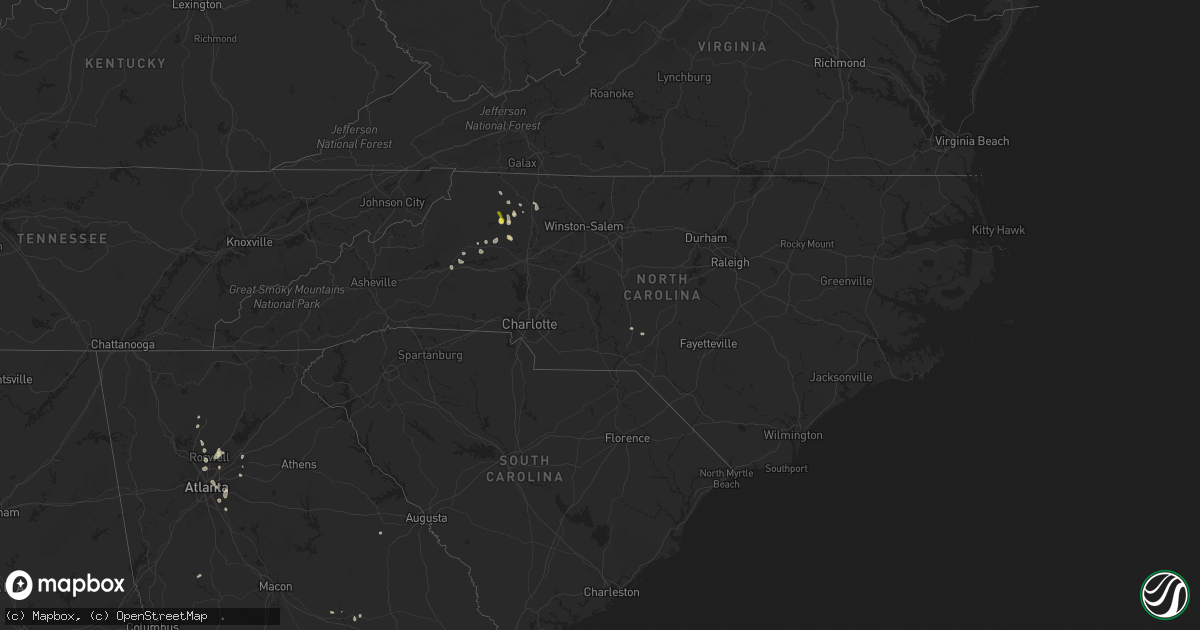
Hail Map in North Carolina on July 27, 2021
Get this storm
July 27 map
$229
one time, instant access
Download today. No call, no setup
Keep the $229
Bought the map and want the full workflow? Apply the entire $229 to a subscription within 7 days. None of it is wasted.
Every map, not just this one
This buys you this map. Subscription and you get every map we run, in the markets you choose from a few cities to whole states to nationwide. Plus real-time alerts the moment a storm fires.
Contact data
Name, contact info, occupancy, even credit band for addresses in the footprint. You go from where it hit to who to call.
Become the source they trust
Unlimited branding weather history reports on demand. You already have the documented answer ready for the property owner, and you are the one who showed up with it.
Property data and RoofTrace estimates
Pull up any address you have got, its value and the exact code rules for that jurisdiction, straight from One Click Code. Then RoofTrace estimates the squares, pitch, and roof value, priced the way you price.
Storm reports in North Carolina
North Carolina
| Date | Description |
|---|---|
| 07/27/20216:06 PM CDT | Tree on 3 cars. Time estimated from radar. |
| 07/27/20216:01 PM CDT | Tree on house. |
| 07/27/20214:23 PM CDT | Tree down on love road just east-southeast of wilkesboro near u.s. 421. |
| 07/27/20214:23 PM CDT | Corrects previous tstm wnd dmg report from 1 sw cricket. Tree down on u.s. 421 at exit 282 near wilkesboro. |
| 07/27/20214:21 PM CDT | Tree down in the 550 block of shady lane on the northeast side of wilkesboro. |
| 07/27/20214:20 PM CDT | Dime to nickel size hail at the wilkes county 911 center for several minutes. |
| 07/27/20214:15 PM CDT | Hail fell for 15 minutes with some hail stones up to the size of half dollars. |
| 07/27/20214:07 PM CDT | Tree down in the 800 block of mt. Pleasant road on the west side of wilkesboro near u.s. 421. |
| 07/27/20214:00 AM CDT | At 900 PM EDT, a severe thunderstorm was located over Burch, or near Fairview, moving east at 10 mph. HAZARD...60 mph wind gusts and quarter size hail. SOURCE...Radar indicated. IMPACT...Hail damage to vehicles is expected. Expect wind damage to roofs, siding, and trees. Locations impacted include... Elkin... Fairview... Jonesville... Boonville... Nebo... Level Cross... and Crutchfield. |
| 07/27/20212:52 AM CDT | At 752 PM EDT, a severe thunderstorm was located 14 miles northeast of Forest City, or 4 miles southwest of Casar, moving southwest at 20 mph. HAZARD...60 mph wind gusts and nickel size hail. SOURCE...Radar indicated. IMPACT...Expect damage to trees and power lines. Locations impacted include... Forest City, Polkville, Ellenboro, Lattimore, Mooresboro, Bostic, Casar, Sunshine, Kingstown and Caroleen. |
| 07/27/20212:00 AM CDT | At 700 PM EDT, a severe thunderstorm was located near Morganton, moving south at 15 mph. HAZARD...60 mph wind gusts and quarter size hail. SOURCE...Radar indicated. IMPACT...Minor hail damage to vehicles is expected. Expect wind damage to trees and power lines. Locations impacted include... Morganton, Drexel, South Mountains State Park and Pleasant Grove. |
| 07/27/202112:10 AM CDT | At 509 PM EDT, a severe thunderstorm was located near North Wilkesboro, moving southeast at 10 mph. HAZARD...60 mph wind gusts and quarter size hail. SOURCE...Radar indicated. IMPACT...Hail damage to vehicles is expected. Expect wind damage to roofs, siding, and trees. Locations impacted include... North Wilkesboro... Wilkesboro... Ronda... Windy Gap... Mulberry... Buck Shoals... and Buck. |
| 07/26/20218:30 PM CDT | Numerous trees down across the town of elkin. |
| 07/26/20218:15 PM CDT | More than a dozen trees down between elkin and stateroad in the west central part of surry county. Time frame based on 911 call log and radar is 910 pm edt to 1000 pm e |
| 07/26/20217:30 PM CDT | One tree down on roadway near the intersection of davidson and broad streets. Reported by social media. |
| 07/26/20217:02 PM CDT | At least a couple trees blown down along highway 226 near the cleveland county border. |
All States Impacted by Hail Map on July 27, 2021
Cities Impacted by Hail Map on July 27, 2021
- Norcross, MN
- Herman, MN
- Dumont, MN
- Cyrus, MN
- Elbow Lake, MN
- Hancock, MN
- Tintah, MN
- Chokio, MN
- Starbuck, MN
- Donnelly, MN
- Morris, MN
- Mildred, PA
- Dushore, PA
- Osakis, MN
- Sauk Centre, MN
- Sulphur, LA
- Decorah, IA
- Waukon, IA
- Postville, IA
- Dorchester, IA
- Unadilla, GA
- Willard, WI
- Fairchild, WI
- Commerce, TX
- Greenville, TX
- Campbell, TX
- Park Rapids, MN
- Shevlin, MN
- Kirbyville, TX
- Blossom, TX
- Wahpeton, ND
- Ettrick, WI
- Melrose, WI
- Mindoro, WI
- Galesville, WI
- Holmen, WI
- Rockland, WI
- Taylor, WI
- Bangor, WI
- West Salem, WI
- Arcadia, WI
- Luana, IA
- Monona, IA
- Nashoba, OK
- Rattan, OK
- Snow, OK
- Hoffman Estates, IL
- Palatine, IL
- Barrington, IL
- Arlington Heights, IL
- Rolling Meadows, IL
- Ponce De Leon, FL
- Cleveland, TX
- North Wilkesboro, NC
- Wilkesboro, NC
- Campbell, MN
- Fairmount, ND
- Lenox, MA
- Pittsfield, MA
- Livingston, WI
- Stitzer, WI
- Platteville, WI
- Lancaster, WI
- Chidester, AR
- Glen Haven, WI
- Bloomington, WI
- Bagley, WI
- Sabin, MN
- Wolverton, MN
- Moorhead, MN
- Taylorsville, NC
- Vienna, GA
- Blair, WI
- Trempealeau, WI
- Dodge, WI
- Sparta, WI
- Menahga, MN
- Nevis, MN
- Winthrop, AR
- Horatio, AR
- Maynard, IA
- Gainesville, TX
- Whitesboro, TX
- Oakfield, GA
- Damascus, GA
- Orange, TX
- Hixton, WI
- Richmond, MA
- Becket, MA
- Lee, MA
- Dalton, MA
- Ignacio, CO
- Honey Grove, TX
- Elko, GA
- East Dubuque, IL
- Bellevue, IA
- Eagle Bend, MN
- Hawkeye, IA
- Quasqueton, IA
- Stanley, IA
- Randalia, IA
- Independence, IA
- Waucoma, IA
- Lawler, IA
- Sumner, IA
- Oelwein, IA
- Fayette, IA
- Hazleton, IA
- Fredericksburg, IA
- New Hampton, IA
- Aurora, IA
- Winthrop, IA
- Arlington, IA
- Westgate, IA
- West Union, IA
- Brandon, MS
- Bienville, LA
- Albany, GA
- Sylvester, GA
- Stoddard, WI
- Gillham, AR
- De Queen, AR
- Farmersburg, IA
- Ronda, NC
- Hokah, MN
- Holy Cross, IA
- North Buena Vista, IA
- Cassville, WI
- Guttenberg, IA
- Staples, MN
- Sebeka, MN
- Horace, ND
- Kindred, ND
- Genoa, WI
- Roaring River, NC
- Columbiana, AL
- Alabaster, AL
- Brantley, AL
- Elba, AL
- Ben Franklin, TX
- Black River Falls, WI
- South Beloit, IL
- Clinton, WI
- Burkeville, TX
- Houston, MN
- Caledonia, MN
- Dublin, GA
- Alpharetta, GA
- Naytahwaush, MN
- La Valle, WI
- Cazenovia, WI
- Weedsport, NY
- Auburn, NY
- Elbridge, NY
- Osseo, WI
- Oregon, WI
- Cragford, AL
- Dassel, MN
- Hutchinson, MN
- Cokato, MN
- Detroit, TX
- Paris, TX
- Roanoke, AL
- Wadley, AL
- Melrose, MN
- Cuba City, WI
- Belmont, WI
- Coushatta, LA
- Campti, LA
- Wyndmere, ND
- Leonard, ND
- Walcott, ND
- Frazee, MN
- Camp Hill, AL
- Kelly, LA
- Grayson, LA
- Chester, IA
- Alexander City, AL
- Kellyton, AL
- Lowell, IN
- Crown Point, IN
- Winger, MN
- Bejou, MN
- Mahnomen, MN
- Harrisonburg, LA
- Dayton, TX
- Fort Worth, TX
- De Soto, WI
- Beecher, IL
- Arkadelphia, AR
- Bagley, MN
- Ponsford, MN
- Plainfield, IL
- Naperville, IL
- Roslyn, SD
- Grenville, SD
- Washington, AR
- Roswell, GA
- Enterprise, MS
- Elgin, MN
- Nashua, MN
- Joliet, IL
- Shorewood, IL
- Pittsview, AL
- Parkers Prairie, MN
- Miltona, MN
- Carlos, MN
- Enderlin, ND
- Deridder, LA
- Hiddenite, NC
- Statesville, NC
- Rembert, SC
- Adrian, GA
- East Dublin, GA
- Ball, LA
- Lafayette, AL
- Galena, IL
- Columbus, GA
- Brownsville, MN
- Glenmora, LA
- Winona, MN
- Jasper, GA
- Ball Ground, GA
- Canton, GA
- Stockbridge, GA
- Wheatland, ND
- Shepherd, TX
- Sheldon, ND
- Chatfield, MN
- Louisville, AL
- Jasper, TX
- Fosston, MN
- Fertile, MN
- Boscobel, WI
- Mount Hope, WI
- Fennimore, WI
- Wauzeka, WI
- Woodman, WI
- Roxton, TX
- Cooper, TX
- Villard, MN
- Glenwood, MN
- Dubuque, IA
- Arlington, GA
- Leary, GA
- La Crosse, WI
- New Albin, IA
- Chaseburg, WI
- Lansing, IA
- Harpers Ferry, IA
- Dakota, MN
- Ferryville, WI
- Coon Valley, WI
- La Crescent, MN
- Viroqua, WI
- Onalaska, WI
- Calera, AL
- Liberty, TX
- Alma Center, WI
- Elkin, NC
- Daviston, AL
- Honobia, OK
- Smithville, OK
- Vicksburg, MS
- Converse, LA
- Pelican, LA
- Colmesneil, TX
- Jordan, NY
- Moravian Falls, NC
- Fort Atkinson, IA
- Saint Lucas, IA
- Riceville, IA
- Le Roy, MN
- Oswego, IL
- Gladstone, VA
- Lawrenceville, GA
- Eyota, MN
- Bronson, TX
- Mount Carroll, IL
- Port Byron, NY
- Watson, OK
- Pollock, LA
- Barrett, MN
- Newton, GA
- Belfield, ND
- Deer Creek, MN
- Saline, LA
- Eufaula, AL
- Granite Falls, NC
- Christine, ND
- Barnesville, MN
- Deport, TX
- Bogata, TX
- Madill, OK
- Mannsville, OK
- Oscar, LA
- Ventress, LA
- Jarreau, LA
- Verona, WI
- Madison, WI
- Alma, WI
- Cochrane, WI
- Lime Springs, IA
- Alta Vista, IA
- Elma, IA
- Langford, SD
- Weatherford, TX
- Spring Valley, MN
- Sharon, WI
- Delta, AL
- Lineville, AL
- Ashland, AL
- Reynolds, GA
- Butler, GA
- Clinton, IA
- Miles, IA
- Johnston, SC
- Warwick, GA
- Fonda, NY
- Opp, AL
- Wetumpka, AL
- Elmore, AL
- Traphill, NC
- Hays, NC
- Dadeville, AL
- Kellogg, MN
- Colesburg, IA
- Sherrill, IA
- Boyce, LA
- Elmer, LA
- Childersburg, AL
- Jacksons Gap, AL
- Belgrade, MN
- Brooten, MN
- Alapaha, GA
- Bluffton, MN
- Wadena, MN
- New York Mills, MN
- Marietta, GA
- Eastaboga, AL
- Oxford, AL
- Munford, AL
- Decatur, GA
- Atlanta, GA
- Motley, MN
- Pine River, MN
- Prairie Du Chien, WI
- Paint Rock, TX
- Eden, TX
- Hineston, LA
- Ladonia, TX
- Cordele, GA
- Springtown, TX
- Long Prairie, MN
- Heavener, OK
- Pinehurst, GA
- Altura, MN
- Rex, GA
- Ellenwood, GA
- Sylacauga, AL
- Lenoir, NC
- Fred, TX
- Cashton, WI
- Norwalk, WI
- Stewartville, MN
- Wykoff, MN
- Cross Hill, SC
- Mountville, SC
- Pittsville, WI
- Marshfield, WI
- Granton, WI
- Jackson Springs, NC
- Mount Holly, AR
- Peosta, IA
- Paducah, TX
- Snellville, GA
- Belcher, LA
- Leonard, MN
- Wilmot, SD
- Henning, MN
- Protivin, IA
- Calmar, IA
- Cresco, IA
- Ridgeway, IA
- Red Oak, OK
- Wister, OK
- Lengby, MN
- Eastman, WI
- Robeline, LA
- Pleasant Hill, LA
- Marthaville, LA
- Harpersville, AL
- Evans, LA
- Leesville, LA
- Freeport, MN
- Paynesville, MN
- Milburn, OK
- Tishomingo, OK
- Saratoga, AR
- Ashdown, AR
- Fulton, AR
- Pittsburg, OK
- Humbird, WI
- Bertha, MN
- Hewitt, MN
- Morganton, NC
- Valdese, NC
- Talihina, OK
- Wilburton, OK
- Hawkinsville, GA
- Woodstock, GA
- Eitzen, MN
- Coleman, GA
- Merrillan, WI
- Neillsville, WI
- Headland, AL
- Ashford, AL
- Webb, AL
- Alexandria, LA
- Dothan, AL
- Cowarts, AL
- Zwolle, LA
- Noble, LA
- Muncy Valley, PA
- Lopez, PA
- Colfax, ND
- Bedford, VA
- Wewoka, OK
- Colquitt, GA
- Janesville, WI
- Peever, SD
- Douglas, GA
- Willacoochee, GA
- Savanna, IL
- Mapleton, ND
- Mooringsport, LA
- Oil City, LA
- Iowa, LA
- Shullsburg, WI
- Scales Mound, IL
- Molena, GA
- Thomaston, GA
- Fitzhugh, OK
- Blakely, GA
- Garnavillo, IA
- Epworth, IA
- Durango, IA
- Beloit, WI
- Patagonia, AZ
- Duluth, GA
- Hanover, IL
- Elizabeth, IL
- Wickes, AR
- Stapleton, GA
- Rayville, LA
- Candor, NC
- Sicily Island, LA
- Lake Charles, LA
- Dequincy, LA
- Kinder, LA
- Ragley, LA
- Fargo, ND
- West Fargo, ND
- Smithville, GA
- Leesburg, GA
- Fort Payne, AL
- Wilton, WI
- Ontario, WI
- Haynesville, LA
- Breckenridge, TX
- Caddo, TX
- Preston, MN
- Harmony, MN
- Boonville, NC
- State Road, NC
- Jonesville, NC
- Jacksboro, TX
- Richmond, MN
- Ostrander, MN
- Olla, LA
- Ada, OK
- Doerun, GA
- Augusta, WI
- Spring Grove, MN
- Elkader, IA
- Saint Olaf, IA
- Columbia, AL
- Newville, AL
- Mittie, LA
- Dry Creek, LA
- Vinton, LA
- Foreman, AR
- Mcleod, ND
- Hebron, IN
- Bagwell, TX
- Clarksville, TX
- Henning, TN
- Ripley, TN
- Vivian, LA
- Lithonia, GA
- Camilla, GA
- Sale City, GA
- Whitehall, WI
- Winthrop, MN
- Jefferson, TX
- Fountain City, WI
- Uniontown, AR
- Rudy, AR
- Chester, AR
- Van Buren, AR
- Cedarville, AR
- Hartshorne, OK
- Elizabeth, LA
- Pitkin, LA
- Defuniak Springs, FL
- Dover, MN
- Rochester, MN
- Millville, MN
- Zumbro Falls, MN
- Pineville, LA
- Deville, LA
- Faber, VA
- Lovingston, VA
- Nellysford, VA
- Alpine, AL
- Talladega, AL
- Morris, GA
- Sumner, GA
- Ashburn, GA
- Lamont, IA
- Bath, NY
- Montour Falls, NY
- Beaver Dams, NY
- Millport, NY
- Watkins Glen, NY
- Prattsburgh, NY
- Dundee, NY
- Bradford, NY
- Hammondsport, NY
- Rock Stream, NY
- Maine, NY
- Newark Valley, NY
- Thompson, PA
- Preston Park, PA
- Starrucca, PA
- Brackney, PA
- Lake Como, PA
- Hancock, NY
- Johnson City, NY
- Lakewood, PA
- Castle Creek, NY
- Binghamton, NY
- Windsor, NY
- Glen Aubrey, NY
- Hallstead, PA
- Kirkwood, NY
- Starlight, PA
- Great Bend, PA
- Equinunk, PA
- Conklin, NY
- Susquehanna, PA
- Endicott, NY
- Greenwood, WI


