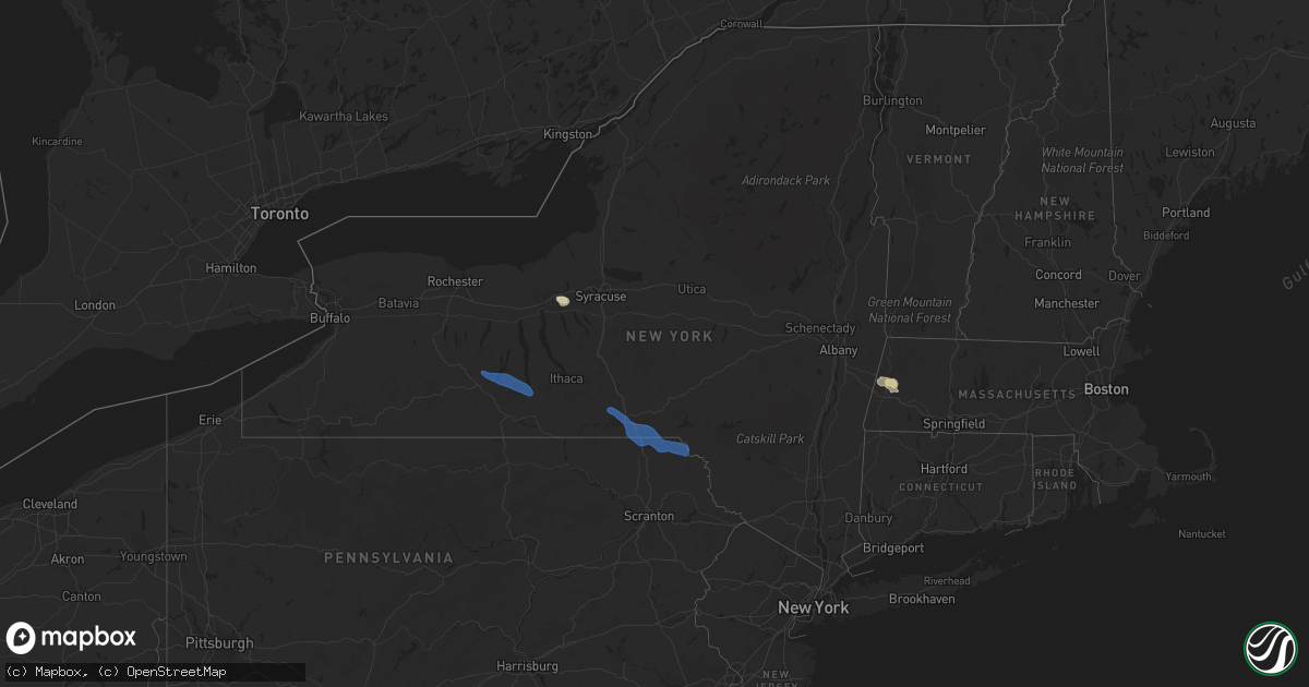
Hail Map in New York on July 27, 2021
Get this storm
July 27 map
$229
one time, instant access
Download today. No call, no setup
Keep the $229
Bought the map and want the full workflow? Apply the entire $229 to a subscription within 7 days. None of it is wasted.
Every map, not just this one
This buys you this map. Subscription and you get every map we run, in the markets you choose from a few cities to whole states to nationwide. Plus real-time alerts the moment a storm fires.
Contact data
Name, contact info, occupancy, even credit band for addresses in the footprint. You go from where it hit to who to call.
Become the source they trust
Unlimited branding weather history reports on demand. You already have the documented answer ready for the property owner, and you are the one who showed up with it.
Property data and RoofTrace estimates
Pull up any address you have got, its value and the exact code rules for that jurisdiction, straight from One Click Code. Then RoofTrace estimates the squares, pitch, and roof value, priced the way you price.
Storm reports in New York
New York
| Date | Description |
|---|---|
| 07/27/20214:10 PM CDT | Tree and wires down. Time estimated by radar. |
| 07/27/20214:10 PM CDT | Trees down from thunderstorm outflow boundary. Time estimated from radar. |
| 07/27/20214:00 PM CDT | Trees down from thunderstorm outflow boundary. |
| 07/27/20213:57 PM CDT | Corrects previous tstm wnd dmg report from 2 w callicoon. Tree and wires down. Time estimated by radar. |
| 07/27/20213:54 PM CDT | Tree and wires down. Time estimated by radar. |
| 07/27/20213:52 PM CDT | Corrects previous tstm wnd dmg report from 3 ne fremont. Multiple reports of trees and wires down along rt 93 in the crystal lake wild forest area. Rt 93 is blocked. Ti |
| 07/27/20213:52 PM CDT | Tree and wires down. Time estimated by radar. |
| 07/27/20213:41 PM CDT | Power pole snapped on broadway |
| 07/27/20213:10 PM CDT | Couple trees down schoharie hill road. Time estimated by radar. |
| 07/27/20213:10 PM CDT | Couple trees on eminence road. Time estimated by radar. |
| 07/27/20213:00 PM CDT | Tree down on house. Time estimated by radar. |
| 07/27/20212:59 PM CDT | Power pole snapped on broadway |
| 07/27/20212:59 PM CDT | Large tree limb downed on howard street |
| 07/27/20212:52 PM CDT | Tree downed on englemore road |
| 07/27/20212:45 PM CDT | Tree down. Time estimated by radar. |
| 07/27/20212:45 PM CDT | Strong thunderstorm winds knocked down a tree on a porch. |
| 07/27/20212:45 PM CDT | Tree down on road. Time estimated by radar. |
| 07/27/20212:44 PM CDT | Tree and wires downed across kennedy lane |
| 07/27/20212:40 PM CDT | Wires downed on riverview drive in rexford |
| 07/27/20212:35 PM CDT | Strong thunderstorm winds broke large tree limbs and also broke utility poles. |
| 07/27/20212:30 PM CDT | Tree and wires down on a house. Time estimated by radar. |
| 07/27/20212:20 PM CDT | Tree and wires down on road. Time estimated by radar. |
| 07/27/20212:03 PM CDT | Corrects previous tstm wnd dmg report from whitney point. Strong thunderstorm winds knocked down wires. Correcting that media source confirmed that the fair grounds wer |
| 07/27/20212:02 PM CDT | Tree down on road near tinker falls. |
| 07/27/20212:00 PM CDT | Large branches down on many properties along mohawk drive. |
| 07/27/20212:00 PM CDT | Two trees down in ft. Hunter near the intersection of main st. And schoharie st. |
| 07/27/20211:53 PM CDT | Tree down on wires at 2972 route 30a |
| 07/27/20211:51 PM CDT | Trees and wires downed on route 30a between route 5 in fonda and chestnut street in johnstown |
| 07/27/20211:47 PM CDT | Strong thunderstorm winds knocked down utility poles and wires down on road. |
| 07/27/20211:42 PM CDT | Strong thunderstorm winds knocked down a tree and wires in front of entry way of a residence. |
| 07/27/20211:25 PM CDT | A local report indicates 59 MPH wind near HARTSVILLE |
| 07/27/20211:19 PM CDT | Corrects previous tstm wnd dmg report from 2 sw pulteney |
| 07/27/20211:07 AM CDT | At 607 PM EDT, a severe thunderstorm was located near Unionville, or 9 miles southeast of Matamoras, moving east at 25 mph. HAZARD...60 mph wind gusts and penny size hail. SOURCE...Radar indicated. IMPACT...Damage to roofs, siding, trees, and power lines is possible. Locations impacted include... Hamburg, Sussex, Vernon Valley, High Point and Highland Lake. |
| 07/27/202112:19 AM CDT | At 519 PM EDT, a severe thunderstorm was located near Lenox, or near Pittsfield, moving east at 35 mph. HAZARD...60 mph wind gusts. SOURCE...Radar indicated. IMPACT...Expect damage to roofs, siding, and trees. Locations impacted include... Pittsfield, Lee, Lenox, Becket, Otis, Hinsdale, Stockbridge, Richmond, West Stockbridge, Washington, Tyringham, Barkerville, Mahkeenac Heights, North Otis, Glendale, Tanglewood, New Lenox, Lenox Dale, The Center At Lenox and Adams Junction. |
| 07/27/202112:09 AM CDT | At 509 PM EDT, a severe thunderstorm was located over Liberty, moving east at 45 mph. HAZARD...60 mph wind gusts. SOURCE...Radar indicated. IMPACT...Expect damage to roofs, siding, and trees. Locations impacted include... Fallsburg, Monticello, Liberty, Bethel, Neversink, South Fallsburg, Wurtsboro, Woodridge, Bloomingburg and Jeffersonville. |
| 07/26/202111:34 PM CDT | At 433 PM EDT, a severe thunderstorm was located over Livingstonville, or 16 miles southeast of Cobleskill, moving east at 50 mph. HAZARD...60 mph wind gusts. SOURCE...Radar indicated. IMPACT...Expect damage to roofs, siding, and trees. Locations impacted include... New Baltimore, Westerlo, Ravena, Coxsackie, Middleburgh, Livingstonville, Preston-Potter Hollow, Preston Hollow, Selkirk, Coeymans, Rensselaerville, Coeymans Hollow, Huntersland, Spawn Hollow, Dormansville. |
| 07/26/202110:51 PM CDT | At 349 PM EDT, severe thunderstorms were located along a line extending from near Harpursville to near Rome, moving southeast at 35 mph. HAZARD...60 mph wind gusts. SOURCE...Law enforcement. IMPACT...Expect damage to roofs, siding, and trees. Locations impacted include... Kirkwood, Conklin, Rush, Jackson, Clifford, Sanford, Susquehanna, Deposit, Susquehanna Depot and Springville. |
| 07/26/202110:20 PM CDT | At 319 PM EDT, a severe thunderstorm was located over West Winfield, or 10 miles southwest of Ilion, moving east at 30 mph. HAZARD...60 mph wind gusts. SOURCE...Radar indicated. IMPACT...Expect damage to roofs, siding, and trees. Locations impacted include... Ilion, West Winfield, Jordanville, Elizabethtown, Jersalem Hill, Spinnerville, Cedar Lake, Chepachet, Columbia Center, Dennison Corners, Smith Corners, Schuyler Corners and Van Hornesville. |
| 07/26/20219:51 PM CDT | At 250 PM EDT, a severe thunderstorm was located over Tribes Hill, or over Fonda, moving east at 30 mph. HAZARD...60 mph wind gusts and quarter size hail. SOURCE...Radar indicated. IMPACT...Hail damage to vehicles is expected. Expect wind damage to roofs, siding, and trees. Locations impacted include... Schenectady, Rotterdam, Amsterdam, Gloversville, Johnstown, Scotia, Fonda, Glenville, Niskayuna, Ballston Spa, Hagaman, Fort Johnson, Galway, Rotterdam Junction, East Glenville, Burnt Hills, Tribes Hill, North Ballston Spa, Alplaus and Pattersonville-Rotterdam Junction. |
| 07/26/20219:29 PM CDT | At 228 PM EDT, severe thunderstorms were located along a line extending from Kirkville to La Fayette to Kelloggsville, moving east at 45 mph. HAZARD...60 mph wind gusts. IMPACT...Expect damage to roofs, siding, and trees. Locations impacted include... Sullivan, Oneida, Lenox, Norwich, Pompey, Eaton, Chittenango, Canastota, Manlius and Paris. |
| 07/26/20219:23 PM CDT | At 221 PM EDT, a severe thunderstorm was located over Tyrone, or 9 miles southwest of Dundee, moving southeast at 30 mph. HAZARD...60 mph wind gusts and penny size hail. SOURCE...Law enforcement. A tree was reported on a residence in Pulteney. IMPACT...Expect damage to roofs, siding, and trees. Locations impacted include... Newfield, Danby, Erin, Watkins Glen, Catharine, Montour Falls, Tyrone, Wayne, Bradford and Spencer. |
All States Impacted by Hail Map on July 27, 2021
Cities Impacted by Hail Map on July 27, 2021
- Norcross, MN
- Herman, MN
- Dumont, MN
- Cyrus, MN
- Elbow Lake, MN
- Hancock, MN
- Tintah, MN
- Chokio, MN
- Starbuck, MN
- Donnelly, MN
- Morris, MN
- Mildred, PA
- Dushore, PA
- Osakis, MN
- Sauk Centre, MN
- Sulphur, LA
- Decorah, IA
- Waukon, IA
- Postville, IA
- Dorchester, IA
- Unadilla, GA
- Willard, WI
- Fairchild, WI
- Commerce, TX
- Greenville, TX
- Campbell, TX
- Park Rapids, MN
- Shevlin, MN
- Kirbyville, TX
- Blossom, TX
- Wahpeton, ND
- Ettrick, WI
- Melrose, WI
- Mindoro, WI
- Galesville, WI
- Holmen, WI
- Rockland, WI
- Taylor, WI
- Bangor, WI
- West Salem, WI
- Arcadia, WI
- Luana, IA
- Monona, IA
- Nashoba, OK
- Rattan, OK
- Snow, OK
- Hoffman Estates, IL
- Palatine, IL
- Barrington, IL
- Arlington Heights, IL
- Rolling Meadows, IL
- Ponce De Leon, FL
- Cleveland, TX
- North Wilkesboro, NC
- Wilkesboro, NC
- Campbell, MN
- Fairmount, ND
- Lenox, MA
- Pittsfield, MA
- Livingston, WI
- Stitzer, WI
- Platteville, WI
- Lancaster, WI
- Chidester, AR
- Glen Haven, WI
- Bloomington, WI
- Bagley, WI
- Sabin, MN
- Wolverton, MN
- Moorhead, MN
- Taylorsville, NC
- Vienna, GA
- Blair, WI
- Trempealeau, WI
- Dodge, WI
- Sparta, WI
- Menahga, MN
- Nevis, MN
- Winthrop, AR
- Horatio, AR
- Maynard, IA
- Gainesville, TX
- Whitesboro, TX
- Oakfield, GA
- Damascus, GA
- Orange, TX
- Hixton, WI
- Richmond, MA
- Becket, MA
- Lee, MA
- Dalton, MA
- Ignacio, CO
- Honey Grove, TX
- Elko, GA
- East Dubuque, IL
- Bellevue, IA
- Eagle Bend, MN
- Hawkeye, IA
- Quasqueton, IA
- Stanley, IA
- Randalia, IA
- Independence, IA
- Waucoma, IA
- Lawler, IA
- Sumner, IA
- Oelwein, IA
- Fayette, IA
- Hazleton, IA
- Fredericksburg, IA
- New Hampton, IA
- Aurora, IA
- Winthrop, IA
- Arlington, IA
- Westgate, IA
- West Union, IA
- Brandon, MS
- Bienville, LA
- Albany, GA
- Sylvester, GA
- Stoddard, WI
- Gillham, AR
- De Queen, AR
- Farmersburg, IA
- Ronda, NC
- Hokah, MN
- Holy Cross, IA
- North Buena Vista, IA
- Cassville, WI
- Guttenberg, IA
- Staples, MN
- Sebeka, MN
- Horace, ND
- Kindred, ND
- Genoa, WI
- Roaring River, NC
- Columbiana, AL
- Alabaster, AL
- Brantley, AL
- Elba, AL
- Ben Franklin, TX
- Black River Falls, WI
- South Beloit, IL
- Clinton, WI
- Burkeville, TX
- Houston, MN
- Caledonia, MN
- Dublin, GA
- Alpharetta, GA
- Naytahwaush, MN
- La Valle, WI
- Cazenovia, WI
- Weedsport, NY
- Auburn, NY
- Elbridge, NY
- Osseo, WI
- Oregon, WI
- Cragford, AL
- Dassel, MN
- Hutchinson, MN
- Cokato, MN
- Detroit, TX
- Paris, TX
- Roanoke, AL
- Wadley, AL
- Melrose, MN
- Cuba City, WI
- Belmont, WI
- Coushatta, LA
- Campti, LA
- Wyndmere, ND
- Leonard, ND
- Walcott, ND
- Frazee, MN
- Camp Hill, AL
- Kelly, LA
- Grayson, LA
- Chester, IA
- Alexander City, AL
- Kellyton, AL
- Lowell, IN
- Crown Point, IN
- Winger, MN
- Bejou, MN
- Mahnomen, MN
- Harrisonburg, LA
- Dayton, TX
- Fort Worth, TX
- De Soto, WI
- Beecher, IL
- Arkadelphia, AR
- Bagley, MN
- Ponsford, MN
- Plainfield, IL
- Naperville, IL
- Roslyn, SD
- Grenville, SD
- Washington, AR
- Roswell, GA
- Enterprise, MS
- Elgin, MN
- Nashua, MN
- Joliet, IL
- Shorewood, IL
- Pittsview, AL
- Parkers Prairie, MN
- Miltona, MN
- Carlos, MN
- Enderlin, ND
- Deridder, LA
- Hiddenite, NC
- Statesville, NC
- Rembert, SC
- Adrian, GA
- East Dublin, GA
- Ball, LA
- Lafayette, AL
- Galena, IL
- Columbus, GA
- Brownsville, MN
- Glenmora, LA
- Winona, MN
- Jasper, GA
- Ball Ground, GA
- Canton, GA
- Stockbridge, GA
- Wheatland, ND
- Shepherd, TX
- Sheldon, ND
- Chatfield, MN
- Louisville, AL
- Jasper, TX
- Fosston, MN
- Fertile, MN
- Boscobel, WI
- Mount Hope, WI
- Fennimore, WI
- Wauzeka, WI
- Woodman, WI
- Roxton, TX
- Cooper, TX
- Villard, MN
- Glenwood, MN
- Dubuque, IA
- Arlington, GA
- Leary, GA
- La Crosse, WI
- New Albin, IA
- Chaseburg, WI
- Lansing, IA
- Harpers Ferry, IA
- Dakota, MN
- Ferryville, WI
- Coon Valley, WI
- La Crescent, MN
- Viroqua, WI
- Onalaska, WI
- Calera, AL
- Liberty, TX
- Alma Center, WI
- Elkin, NC
- Daviston, AL
- Honobia, OK
- Smithville, OK
- Vicksburg, MS
- Converse, LA
- Pelican, LA
- Colmesneil, TX
- Jordan, NY
- Moravian Falls, NC
- Fort Atkinson, IA
- Saint Lucas, IA
- Riceville, IA
- Le Roy, MN
- Oswego, IL
- Gladstone, VA
- Lawrenceville, GA
- Eyota, MN
- Bronson, TX
- Mount Carroll, IL
- Port Byron, NY
- Watson, OK
- Pollock, LA
- Barrett, MN
- Newton, GA
- Belfield, ND
- Deer Creek, MN
- Saline, LA
- Eufaula, AL
- Granite Falls, NC
- Christine, ND
- Barnesville, MN
- Deport, TX
- Bogata, TX
- Madill, OK
- Mannsville, OK
- Oscar, LA
- Ventress, LA
- Jarreau, LA
- Verona, WI
- Madison, WI
- Alma, WI
- Cochrane, WI
- Lime Springs, IA
- Alta Vista, IA
- Elma, IA
- Langford, SD
- Weatherford, TX
- Spring Valley, MN
- Sharon, WI
- Delta, AL
- Lineville, AL
- Ashland, AL
- Reynolds, GA
- Butler, GA
- Clinton, IA
- Miles, IA
- Johnston, SC
- Warwick, GA
- Fonda, NY
- Opp, AL
- Wetumpka, AL
- Elmore, AL
- Traphill, NC
- Hays, NC
- Dadeville, AL
- Kellogg, MN
- Colesburg, IA
- Sherrill, IA
- Boyce, LA
- Elmer, LA
- Childersburg, AL
- Jacksons Gap, AL
- Belgrade, MN
- Brooten, MN
- Alapaha, GA
- Bluffton, MN
- Wadena, MN
- New York Mills, MN
- Marietta, GA
- Eastaboga, AL
- Oxford, AL
- Munford, AL
- Decatur, GA
- Atlanta, GA
- Motley, MN
- Pine River, MN
- Prairie Du Chien, WI
- Paint Rock, TX
- Eden, TX
- Hineston, LA
- Ladonia, TX
- Cordele, GA
- Springtown, TX
- Long Prairie, MN
- Heavener, OK
- Pinehurst, GA
- Altura, MN
- Rex, GA
- Ellenwood, GA
- Sylacauga, AL
- Lenoir, NC
- Fred, TX
- Cashton, WI
- Norwalk, WI
- Stewartville, MN
- Wykoff, MN
- Cross Hill, SC
- Mountville, SC
- Pittsville, WI
- Marshfield, WI
- Granton, WI
- Jackson Springs, NC
- Mount Holly, AR
- Peosta, IA
- Paducah, TX
- Snellville, GA
- Belcher, LA
- Leonard, MN
- Wilmot, SD
- Henning, MN
- Protivin, IA
- Calmar, IA
- Cresco, IA
- Ridgeway, IA
- Red Oak, OK
- Wister, OK
- Lengby, MN
- Eastman, WI
- Robeline, LA
- Pleasant Hill, LA
- Marthaville, LA
- Harpersville, AL
- Evans, LA
- Leesville, LA
- Freeport, MN
- Paynesville, MN
- Milburn, OK
- Tishomingo, OK
- Saratoga, AR
- Ashdown, AR
- Fulton, AR
- Pittsburg, OK
- Humbird, WI
- Bertha, MN
- Hewitt, MN
- Morganton, NC
- Valdese, NC
- Talihina, OK
- Wilburton, OK
- Hawkinsville, GA
- Woodstock, GA
- Eitzen, MN
- Coleman, GA
- Merrillan, WI
- Neillsville, WI
- Headland, AL
- Ashford, AL
- Webb, AL
- Alexandria, LA
- Dothan, AL
- Cowarts, AL
- Zwolle, LA
- Noble, LA
- Muncy Valley, PA
- Lopez, PA
- Colfax, ND
- Bedford, VA
- Wewoka, OK
- Colquitt, GA
- Janesville, WI
- Peever, SD
- Douglas, GA
- Willacoochee, GA
- Savanna, IL
- Mapleton, ND
- Mooringsport, LA
- Oil City, LA
- Iowa, LA
- Shullsburg, WI
- Scales Mound, IL
- Molena, GA
- Thomaston, GA
- Fitzhugh, OK
- Blakely, GA
- Garnavillo, IA
- Epworth, IA
- Durango, IA
- Beloit, WI
- Patagonia, AZ
- Duluth, GA
- Hanover, IL
- Elizabeth, IL
- Wickes, AR
- Stapleton, GA
- Rayville, LA
- Candor, NC
- Sicily Island, LA
- Lake Charles, LA
- Dequincy, LA
- Kinder, LA
- Ragley, LA
- Fargo, ND
- West Fargo, ND
- Smithville, GA
- Leesburg, GA
- Fort Payne, AL
- Wilton, WI
- Ontario, WI
- Haynesville, LA
- Breckenridge, TX
- Caddo, TX
- Preston, MN
- Harmony, MN
- Boonville, NC
- State Road, NC
- Jonesville, NC
- Jacksboro, TX
- Richmond, MN
- Ostrander, MN
- Olla, LA
- Ada, OK
- Doerun, GA
- Augusta, WI
- Spring Grove, MN
- Elkader, IA
- Saint Olaf, IA
- Columbia, AL
- Newville, AL
- Mittie, LA
- Dry Creek, LA
- Vinton, LA
- Foreman, AR
- Mcleod, ND
- Hebron, IN
- Bagwell, TX
- Clarksville, TX
- Henning, TN
- Ripley, TN
- Vivian, LA
- Lithonia, GA
- Camilla, GA
- Sale City, GA
- Whitehall, WI
- Winthrop, MN
- Jefferson, TX
- Fountain City, WI
- Uniontown, AR
- Rudy, AR
- Chester, AR
- Van Buren, AR
- Cedarville, AR
- Hartshorne, OK
- Elizabeth, LA
- Pitkin, LA
- Defuniak Springs, FL
- Dover, MN
- Rochester, MN
- Millville, MN
- Zumbro Falls, MN
- Pineville, LA
- Deville, LA
- Faber, VA
- Lovingston, VA
- Nellysford, VA
- Alpine, AL
- Talladega, AL
- Morris, GA
- Sumner, GA
- Ashburn, GA
- Lamont, IA
- Bath, NY
- Montour Falls, NY
- Beaver Dams, NY
- Millport, NY
- Watkins Glen, NY
- Prattsburgh, NY
- Dundee, NY
- Bradford, NY
- Hammondsport, NY
- Rock Stream, NY
- Maine, NY
- Newark Valley, NY
- Thompson, PA
- Preston Park, PA
- Starrucca, PA
- Brackney, PA
- Lake Como, PA
- Hancock, NY
- Johnson City, NY
- Lakewood, PA
- Castle Creek, NY
- Binghamton, NY
- Windsor, NY
- Glen Aubrey, NY
- Hallstead, PA
- Kirkwood, NY
- Starlight, PA
- Great Bend, PA
- Equinunk, PA
- Conklin, NY
- Susquehanna, PA
- Endicott, NY
- Greenwood, WI


