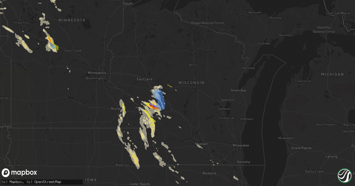
Hail Map in Wisconsin on July 27, 2021
Get this storm
July 27 map
$229
one time, instant access
Download today. No call, no setup
Keep the $229
Bought the map and want the full workflow? Apply the entire $229 to a subscription within 7 days. None of it is wasted.
Every map, not just this one
This buys you this map. Subscription and you get every map we run, in the markets you choose from a few cities to whole states to nationwide. Plus real-time alerts the moment a storm fires.
Contact data
Name, contact info, occupancy, even credit band for addresses in the footprint. You go from where it hit to who to call.
Become the source they trust
Unlimited branding weather history reports on demand. You already have the documented answer ready for the property owner, and you are the one who showed up with it.
Property data and RoofTrace estimates
Pull up any address you have got, its value and the exact code rules for that jurisdiction, straight from One Click Code. Then RoofTrace estimates the squares, pitch, and roof value, priced the way you price.
Storm reports in Wisconsin
Wisconsin
| Date | Description |
|---|---|
| 07/27/202112:18 PM CDT | A local report indicates 1.50 inch wind near MINDORO |
| 07/27/202112:05 PM CDT | Relayed via social media with picture of tennis to baseball size hail. Lasted for about 10 minutes. |
| 07/27/20218:42 AM CDT | Report from mping. |
| 07/27/20218:40 AM CDT | Time estimated from radar. |
| 07/27/20218:35 AM CDT | Time estimated from radar. |
| 07/27/20218:06 AM CDT | A local report indicates 60 MPH wind near CATARACT |
| 07/27/20218:05 AM CDT | 1 tree down on feather avenue. Time estimated from radar. |
| 07/27/20217:55 AM CDT | 2 trees down along state highway 27. Time estimated from radar. |
| 07/27/20217:51 AM CDT | At 1251 AM CDT, severe thunderstorms were located along a line extending from 6 miles east of Menominee to near Bay Shore Park to Kaukauna, moving southeast at 55 mph. HAZARD...60 mph wind gusts. SOURCE...Radar indicated. IMPACT...Expect damage to roofs, siding, and trees. Severe thunderstorms will be near... Luxemburg around 100 AM CDT. Egg Harbor around 105 AM CDT. Kewaunee and Jacksonport around 110 AM CDT.Other locations impacted by these severe thunderstorms include Krok,Peninsula State Park, Valmy, Curran, Slovan, Gregorville, Rankin,Rock Island State Park, Carlsville and Vignes. |
| 07/27/20217:49 AM CDT | At 1248 AM CDT, a severe thunderstorm was located 8 miles southeast of Wascott, or 10 miles northwest of Hayward, moving southeast at 35 mph. HAZARD...Ping pong ball size hail and 60 mph wind gusts. SOURCE...Radar indicated. IMPACT...People and animals outdoors will be injured. Expect hail damage to roofs, siding, windows, and vehicles. Expect wind damage to roofs, siding, and trees. This severe thunderstorm will be near... Hayward and Seeley around 105 AM CDT.Other locations in the path of this severe thunderstorm include RoundLake, Little Round Lake, Chief Lake on Chippewa Flowage, ChippewaFlowage West, Chippewa Flowage East and New Post. |
| 07/27/20217:25 AM CDT | At 1224 AM CDT, a severe thunderstorm was located near Namekagon, or 18 miles northeast of Chippewa Flowage East, moving southeast at 35 mph. HAZARD...Golf ball size hail and 60 mph wind gusts. SOURCE...Radar indicated. IMPACT...People and animals outdoors will be injured. Expect hail damage to roofs, siding, windows, and vehicles. Expect wind damage to roofs, siding, and trees. This severe thunderstorm will be near... Clam Lake around 1230 AM CDT.Other locations in the path of this severe thunderstorm includeButternut. |
| 07/27/20217:12 AM CDT | A local report indicates 1.00 inch wind near GRANTON |
| 07/27/20217:00 AM CDT | At 1200 PM CDT, a severe thunderstorm was located near Galesville, or 14 miles southeast of Arcadia, moving southeast at 40 mph. HAZARD...Two inch hail and 60 mph wind gusts. SOURCE...Radar indicated. IMPACT...People and animals outdoors will be injured. Expect hail damage to roofs, siding, windows, and vehicles. Expect wind damage to roofs, siding, and trees. This severe thunderstorm will be near... North Bend around 1210 PM CDT. West Salem around 1225 PM CDT. Bangor around 1230 PM CDT.This includes Interstate 90 in Wisconsin between mile markers 9 and 20. |
| 07/27/20216:54 AM CDT | At 1154 AM CDT, a severe thunderstorm was located near Galesville, or 10 miles southeast of Arcadia, moving southeast at 40 mph. HAZARD...60 mph wind gusts and quarter size hail. SOURCE...Radar indicated. IMPACT...Hail damage to vehicles is expected. Expect wind damage to roofs, siding, and trees. This severe thunderstorm will be near... North Bend around 1210 PM CDT. West Salem around 1225 PM CDT. Bangor around 1230 PM CDT.Other locations impacted by this severe thunderstorm include CampDecorah, Stevenstown, Rockland, County Roads D E And E, SeversonCoulee, Mindoro and Newburg Corners.This includes Interstate 90 in Wisconsin between mile markers 9 and20. |
| 07/27/20213:30 AM CDT | At 830 PM CDT, a severe thunderstorm was located near Plainview, or 15 miles southwest of Wabasha, moving southeast at 10 mph. HAZARD...Quarter size hail. SOURCE...Radar indicated. IMPACT...Damage to vehicles is expected. This severe thunderstorm will be near... Elgin around 845 PM CDT. Plainview around 900 PM CDT.Other locations impacted by this severe thunderstorm include SouthTroy, Whitewater State Park, County Roads 9 And 10, RattelsnakePoint, Potsdam, County Roads 28 And 31 and Rattlesnake Ridge.This includes Interstate 90 in Minnesota between mile markers 225 and233. |
| 07/27/20212:40 AM CDT | A few trees down. Time estimated based on radar. |
| 07/27/20212:33 AM CDT | At 732 AM CDT, severe thunderstorms were located along a line extending from Shortville to 7 miles northeast of Blair, moving southeast at 40 mph. HAZARD...60 mph wind gusts. SOURCE...Radar indicated. IMPACT...Expect damage to roofs, siding, and trees. Severe thunderstorms will be near... Cataract around 810 AM CDT. Sparta and Fort Mc Coy around 820 AM CDT.Other locations impacted by these severe thunderstorms includeFranklin, Shamrock, The Black River Correctional Center, PottersFlowage, Perry Creek Recreation Area, Jellystone Park Near Warrensand The Rezin Landing Strip.This includes the following highways... Interstate 94 between mile markers 101 and 147. Interstate 90/94 between mile markers 46 and 52. Interstate 90 in Wisconsin between mile markers 21 and 45. |
| 07/26/20218:28 PM CDT | At 128 AM CDT, a severe thunderstorm was located near Willow Reservoir, or 24 miles west of Rhinelander, moving southeast at 40 mph. HAZARD...60 mph wind gusts and quarter size hail. SOURCE...Radar indicated. IMPACT...Hail damage to vehicles is expected. Expect wind damage to roofs, siding, and trees. This severe thunderstorm will remain over mainly rural areas of southwestern Oneida County, including the following locations... Gobler Lake Natural Area, Tomahawk River Pines Natural Area, Lower Tomahawk River Natural Area, Goodnow, Harshaw and Mccord. |
| 07/26/20218:27 PM CDT | At 126 AM CDT, severe thunderstorms were located along a line extending from near Chippewa Flowage East, to near Chief Lake on Chippewa Flowage, to Stone Lake, moving southeast at 45 mph. HAZARD...70 mph wind gusts and half dollar size hail. SOURCE...Radar indicated. IMPACT...Hail damage to vehicles is expected. Expect considerable tree damage. Wind damage is also likely to mobile homes, roofs, and outbuildings. Severe thunderstorms will be near... Chippewa Flowage East, Chippewa Flowage West and New Post around 130 AM CDT. Couderay around 135 AM CDT. Radisson around 140 AM CDT. Winter around 145 AM CDT. Exeland around 155 AM CDT.Other locations impacted by these severe thunderstorms includeConnors Lake, Reserve, Northwoods Beach, Chief Lake, Loretta,Sissabagama Lake, Lac Courte Oreilles Reservation, Lac CourteOreilles, Grindstone Lake and Chippewa Lake. |
All States Impacted by Hail Map on July 27, 2021
Cities Impacted by Hail Map on July 27, 2021
- Norcross, MN
- Herman, MN
- Dumont, MN
- Cyrus, MN
- Elbow Lake, MN
- Hancock, MN
- Tintah, MN
- Chokio, MN
- Starbuck, MN
- Donnelly, MN
- Morris, MN
- Mildred, PA
- Dushore, PA
- Osakis, MN
- Sauk Centre, MN
- Sulphur, LA
- Decorah, IA
- Waukon, IA
- Postville, IA
- Dorchester, IA
- Unadilla, GA
- Willard, WI
- Fairchild, WI
- Commerce, TX
- Greenville, TX
- Campbell, TX
- Park Rapids, MN
- Shevlin, MN
- Kirbyville, TX
- Blossom, TX
- Wahpeton, ND
- Ettrick, WI
- Melrose, WI
- Mindoro, WI
- Galesville, WI
- Holmen, WI
- Rockland, WI
- Taylor, WI
- Bangor, WI
- West Salem, WI
- Arcadia, WI
- Luana, IA
- Monona, IA
- Nashoba, OK
- Rattan, OK
- Snow, OK
- Hoffman Estates, IL
- Palatine, IL
- Barrington, IL
- Arlington Heights, IL
- Rolling Meadows, IL
- Ponce De Leon, FL
- Cleveland, TX
- North Wilkesboro, NC
- Wilkesboro, NC
- Campbell, MN
- Fairmount, ND
- Lenox, MA
- Pittsfield, MA
- Livingston, WI
- Stitzer, WI
- Platteville, WI
- Lancaster, WI
- Chidester, AR
- Glen Haven, WI
- Bloomington, WI
- Bagley, WI
- Sabin, MN
- Wolverton, MN
- Moorhead, MN
- Taylorsville, NC
- Vienna, GA
- Blair, WI
- Trempealeau, WI
- Dodge, WI
- Sparta, WI
- Menahga, MN
- Nevis, MN
- Winthrop, AR
- Horatio, AR
- Maynard, IA
- Gainesville, TX
- Whitesboro, TX
- Oakfield, GA
- Damascus, GA
- Orange, TX
- Hixton, WI
- Richmond, MA
- Becket, MA
- Lee, MA
- Dalton, MA
- Ignacio, CO
- Honey Grove, TX
- Elko, GA
- East Dubuque, IL
- Bellevue, IA
- Eagle Bend, MN
- Hawkeye, IA
- Quasqueton, IA
- Stanley, IA
- Randalia, IA
- Independence, IA
- Waucoma, IA
- Lawler, IA
- Sumner, IA
- Oelwein, IA
- Fayette, IA
- Hazleton, IA
- Fredericksburg, IA
- New Hampton, IA
- Aurora, IA
- Winthrop, IA
- Arlington, IA
- Westgate, IA
- West Union, IA
- Brandon, MS
- Bienville, LA
- Albany, GA
- Sylvester, GA
- Stoddard, WI
- Gillham, AR
- De Queen, AR
- Farmersburg, IA
- Ronda, NC
- Hokah, MN
- Holy Cross, IA
- North Buena Vista, IA
- Cassville, WI
- Guttenberg, IA
- Staples, MN
- Sebeka, MN
- Horace, ND
- Kindred, ND
- Genoa, WI
- Roaring River, NC
- Columbiana, AL
- Alabaster, AL
- Brantley, AL
- Elba, AL
- Ben Franklin, TX
- Black River Falls, WI
- South Beloit, IL
- Clinton, WI
- Burkeville, TX
- Houston, MN
- Caledonia, MN
- Dublin, GA
- Alpharetta, GA
- Naytahwaush, MN
- La Valle, WI
- Cazenovia, WI
- Weedsport, NY
- Auburn, NY
- Elbridge, NY
- Osseo, WI
- Oregon, WI
- Cragford, AL
- Dassel, MN
- Hutchinson, MN
- Cokato, MN
- Detroit, TX
- Paris, TX
- Roanoke, AL
- Wadley, AL
- Melrose, MN
- Cuba City, WI
- Belmont, WI
- Coushatta, LA
- Campti, LA
- Wyndmere, ND
- Leonard, ND
- Walcott, ND
- Frazee, MN
- Camp Hill, AL
- Kelly, LA
- Grayson, LA
- Chester, IA
- Alexander City, AL
- Kellyton, AL
- Lowell, IN
- Crown Point, IN
- Winger, MN
- Bejou, MN
- Mahnomen, MN
- Harrisonburg, LA
- Dayton, TX
- Fort Worth, TX
- De Soto, WI
- Beecher, IL
- Arkadelphia, AR
- Bagley, MN
- Ponsford, MN
- Plainfield, IL
- Naperville, IL
- Roslyn, SD
- Grenville, SD
- Washington, AR
- Roswell, GA
- Enterprise, MS
- Elgin, MN
- Nashua, MN
- Joliet, IL
- Shorewood, IL
- Pittsview, AL
- Parkers Prairie, MN
- Miltona, MN
- Carlos, MN
- Enderlin, ND
- Deridder, LA
- Hiddenite, NC
- Statesville, NC
- Rembert, SC
- Adrian, GA
- East Dublin, GA
- Ball, LA
- Lafayette, AL
- Galena, IL
- Columbus, GA
- Brownsville, MN
- Glenmora, LA
- Winona, MN
- Jasper, GA
- Ball Ground, GA
- Canton, GA
- Stockbridge, GA
- Wheatland, ND
- Shepherd, TX
- Sheldon, ND
- Chatfield, MN
- Louisville, AL
- Jasper, TX
- Fosston, MN
- Fertile, MN
- Boscobel, WI
- Mount Hope, WI
- Fennimore, WI
- Wauzeka, WI
- Woodman, WI
- Roxton, TX
- Cooper, TX
- Villard, MN
- Glenwood, MN
- Dubuque, IA
- Arlington, GA
- Leary, GA
- La Crosse, WI
- New Albin, IA
- Chaseburg, WI
- Lansing, IA
- Harpers Ferry, IA
- Dakota, MN
- Ferryville, WI
- Coon Valley, WI
- La Crescent, MN
- Viroqua, WI
- Onalaska, WI
- Calera, AL
- Liberty, TX
- Alma Center, WI
- Elkin, NC
- Daviston, AL
- Honobia, OK
- Smithville, OK
- Vicksburg, MS
- Converse, LA
- Pelican, LA
- Colmesneil, TX
- Jordan, NY
- Moravian Falls, NC
- Fort Atkinson, IA
- Saint Lucas, IA
- Riceville, IA
- Le Roy, MN
- Oswego, IL
- Gladstone, VA
- Lawrenceville, GA
- Eyota, MN
- Bronson, TX
- Mount Carroll, IL
- Port Byron, NY
- Watson, OK
- Pollock, LA
- Barrett, MN
- Newton, GA
- Belfield, ND
- Deer Creek, MN
- Saline, LA
- Eufaula, AL
- Granite Falls, NC
- Christine, ND
- Barnesville, MN
- Deport, TX
- Bogata, TX
- Madill, OK
- Mannsville, OK
- Oscar, LA
- Ventress, LA
- Jarreau, LA
- Verona, WI
- Madison, WI
- Alma, WI
- Cochrane, WI
- Lime Springs, IA
- Alta Vista, IA
- Elma, IA
- Langford, SD
- Weatherford, TX
- Spring Valley, MN
- Sharon, WI
- Delta, AL
- Lineville, AL
- Ashland, AL
- Reynolds, GA
- Butler, GA
- Clinton, IA
- Miles, IA
- Johnston, SC
- Warwick, GA
- Fonda, NY
- Opp, AL
- Wetumpka, AL
- Elmore, AL
- Traphill, NC
- Hays, NC
- Dadeville, AL
- Kellogg, MN
- Colesburg, IA
- Sherrill, IA
- Boyce, LA
- Elmer, LA
- Childersburg, AL
- Jacksons Gap, AL
- Belgrade, MN
- Brooten, MN
- Alapaha, GA
- Bluffton, MN
- Wadena, MN
- New York Mills, MN
- Marietta, GA
- Eastaboga, AL
- Oxford, AL
- Munford, AL
- Decatur, GA
- Atlanta, GA
- Motley, MN
- Pine River, MN
- Prairie Du Chien, WI
- Paint Rock, TX
- Eden, TX
- Hineston, LA
- Ladonia, TX
- Cordele, GA
- Springtown, TX
- Long Prairie, MN
- Heavener, OK
- Pinehurst, GA
- Altura, MN
- Rex, GA
- Ellenwood, GA
- Sylacauga, AL
- Lenoir, NC
- Fred, TX
- Cashton, WI
- Norwalk, WI
- Stewartville, MN
- Wykoff, MN
- Cross Hill, SC
- Mountville, SC
- Pittsville, WI
- Marshfield, WI
- Granton, WI
- Jackson Springs, NC
- Mount Holly, AR
- Peosta, IA
- Paducah, TX
- Snellville, GA
- Belcher, LA
- Leonard, MN
- Wilmot, SD
- Henning, MN
- Protivin, IA
- Calmar, IA
- Cresco, IA
- Ridgeway, IA
- Red Oak, OK
- Wister, OK
- Lengby, MN
- Eastman, WI
- Robeline, LA
- Pleasant Hill, LA
- Marthaville, LA
- Harpersville, AL
- Evans, LA
- Leesville, LA
- Freeport, MN
- Paynesville, MN
- Milburn, OK
- Tishomingo, OK
- Saratoga, AR
- Ashdown, AR
- Fulton, AR
- Pittsburg, OK
- Humbird, WI
- Bertha, MN
- Hewitt, MN
- Morganton, NC
- Valdese, NC
- Talihina, OK
- Wilburton, OK
- Hawkinsville, GA
- Woodstock, GA
- Eitzen, MN
- Coleman, GA
- Merrillan, WI
- Neillsville, WI
- Headland, AL
- Ashford, AL
- Webb, AL
- Alexandria, LA
- Dothan, AL
- Cowarts, AL
- Zwolle, LA
- Noble, LA
- Muncy Valley, PA
- Lopez, PA
- Colfax, ND
- Bedford, VA
- Wewoka, OK
- Colquitt, GA
- Janesville, WI
- Peever, SD
- Douglas, GA
- Willacoochee, GA
- Savanna, IL
- Mapleton, ND
- Mooringsport, LA
- Oil City, LA
- Iowa, LA
- Shullsburg, WI
- Scales Mound, IL
- Molena, GA
- Thomaston, GA
- Fitzhugh, OK
- Blakely, GA
- Garnavillo, IA
- Epworth, IA
- Durango, IA
- Beloit, WI
- Patagonia, AZ
- Duluth, GA
- Hanover, IL
- Elizabeth, IL
- Wickes, AR
- Stapleton, GA
- Rayville, LA
- Candor, NC
- Sicily Island, LA
- Lake Charles, LA
- Dequincy, LA
- Kinder, LA
- Ragley, LA
- Fargo, ND
- West Fargo, ND
- Smithville, GA
- Leesburg, GA
- Fort Payne, AL
- Wilton, WI
- Ontario, WI
- Haynesville, LA
- Breckenridge, TX
- Caddo, TX
- Preston, MN
- Harmony, MN
- Boonville, NC
- State Road, NC
- Jonesville, NC
- Jacksboro, TX
- Richmond, MN
- Ostrander, MN
- Olla, LA
- Ada, OK
- Doerun, GA
- Augusta, WI
- Spring Grove, MN
- Elkader, IA
- Saint Olaf, IA
- Columbia, AL
- Newville, AL
- Mittie, LA
- Dry Creek, LA
- Vinton, LA
- Foreman, AR
- Mcleod, ND
- Hebron, IN
- Bagwell, TX
- Clarksville, TX
- Henning, TN
- Ripley, TN
- Vivian, LA
- Lithonia, GA
- Camilla, GA
- Sale City, GA
- Whitehall, WI
- Winthrop, MN
- Jefferson, TX
- Fountain City, WI
- Uniontown, AR
- Rudy, AR
- Chester, AR
- Van Buren, AR
- Cedarville, AR
- Hartshorne, OK
- Elizabeth, LA
- Pitkin, LA
- Defuniak Springs, FL
- Dover, MN
- Rochester, MN
- Millville, MN
- Zumbro Falls, MN
- Pineville, LA
- Deville, LA
- Faber, VA
- Lovingston, VA
- Nellysford, VA
- Alpine, AL
- Talladega, AL
- Morris, GA
- Sumner, GA
- Ashburn, GA
- Lamont, IA
- Bath, NY
- Montour Falls, NY
- Beaver Dams, NY
- Millport, NY
- Watkins Glen, NY
- Prattsburgh, NY
- Dundee, NY
- Bradford, NY
- Hammondsport, NY
- Rock Stream, NY
- Maine, NY
- Newark Valley, NY
- Thompson, PA
- Preston Park, PA
- Starrucca, PA
- Brackney, PA
- Lake Como, PA
- Hancock, NY
- Johnson City, NY
- Lakewood, PA
- Castle Creek, NY
- Binghamton, NY
- Windsor, NY
- Glen Aubrey, NY
- Hallstead, PA
- Kirkwood, NY
- Starlight, PA
- Great Bend, PA
- Equinunk, PA
- Conklin, NY
- Susquehanna, PA
- Endicott, NY
- Greenwood, WI


