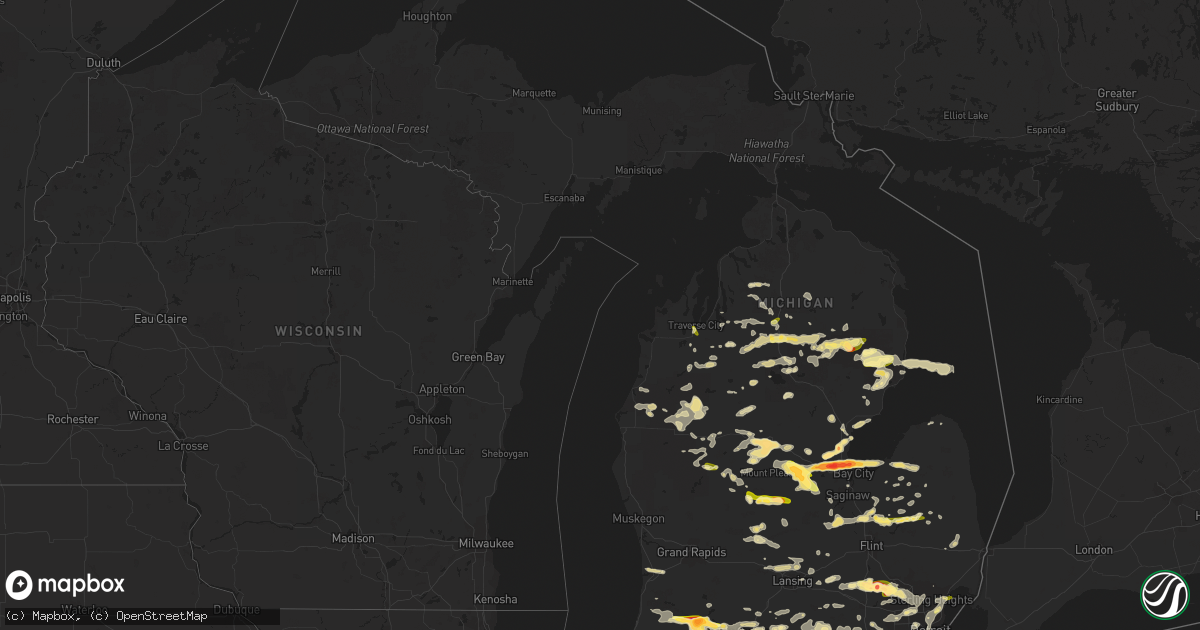
Hail Map in Michigan on July 27, 2014
Get this storm
July 27 map
$229
one time, instant access
Download today. No call, no setup
Keep the $229
Bought the map and want the full workflow? Apply the entire $229 to a subscription within 7 days. None of it is wasted.
Every map, not just this one
This buys you this map. Subscription and you get every map we run, in the markets you choose from a few cities to whole states to nationwide. Plus real-time alerts the moment a storm fires.
Contact data
Name, contact info, occupancy, even credit band for addresses in the footprint. You go from where it hit to who to call.
Become the source they trust
Unlimited branding weather history reports on demand. You already have the documented answer ready for the property owner, and you are the one who showed up with it.
Property data and RoofTrace estimates
Pull up any address you have got, its value and the exact code rules for that jurisdiction, straight from One Click Code. Then RoofTrace estimates the squares, pitch, and roof value, priced the way you price.
Storm reports in Michigan
Michigan
| Date | Description |
|---|---|
| 07/27/20146:17 PM CDT | A couple of downed trees |
| 07/27/20146:04 PM CDT | 10 trees down blocking road |
| 07/27/20145:51 PM CDT | At green and plymouth |
| 07/27/20145:51 PM CDT | 14 inch tree limb reported down. |
| 07/27/20145:46 PM CDT | 3 foot diameter tree down on a house at jefferson and east |
| 07/27/20145:30 PM CDT | Large limbs down near waterloo and roe roads |
| 07/27/20145:30 PM CDT | 10 inch diameter limb down |
| 07/27/20145:29 PM CDT | Eaton 911 center reporting trees down in the area to include wilcox rd near boody hwy and houston rd |
| 07/27/20145:25 PM CDT | Trees down near telegraph and armstrong |
| 07/27/20145:21 PM CDT | A local report indicates 1.00 inch wind near MANCHESTER |
| 07/27/20145:21 PM CDT | At austin rd and manchester rd |
| 07/27/20145:13 PM CDT | Trees and wires reported down in leslie and onondaga area. |
| 07/27/20145:00 PM CDT | Limbs down and power outages |
| 07/27/20144:53 PM CDT | Trees down up to 3 feet in diameter on m-57 between irish rd and m-15 |
| 07/27/20144:53 PM CDT | Tree down at m50 and billmyer rd |
| 07/27/20144:47 PM CDT | Tree limbs greater than one foot diameter down near metro beach in harrison twp |
| 07/27/20144:46 PM CDT | Large tree fell onto house. Multiple large tree limbs also down. |
| 07/27/20144:46 PM CDT | Trees snapped and uprooted at metro villa dr and north pointe pkwy in harrison twp |
| 07/27/20144:37 PM CDT | 25 mile and jewell |
| 07/27/20144:30 PM CDT | A local report indicates 1.25 inch wind near EDMORE |
| 07/27/20144:30 PM CDT | Large branch down on powerlines |
| 07/27/20144:30 PM CDT | A local report indicates 60 MPH wind near 3 SE BIRCH RUN |
| 07/27/20144:30 PM CDT | At martin and hoover |
| 07/27/20144:28 PM CDT | Small branches down |
| 07/27/20144:24 PM CDT | Few trees reported down by em |
| 07/27/20144:20 PM CDT | Fell for 7 minutes at half dollar size. Also 45 mph gust. |
| 07/27/20144:15 PM CDT | One large limb down at stanford and cambridge in berkley |
| 07/27/20144:15 PM CDT | 15 inch diameter limb down |
| 07/27/20144:14 PM CDT | Large tree limbs down at 12 mile and dequindre |
| 07/27/20144:10 PM CDT | At square lake and woodward |
| 07/27/20144:07 PM CDT | Barn roof torn off... Trees uprooted. Fergus rd in st charles |
| 07/27/20144:07 PM CDT | Spotter estimated quarter size hail falling at the time of report |
| 07/27/20144:07 PM CDT | Power lines down for one half mile and damage to porch at birch run and stewart |
| 07/27/20144:05 PM CDT | At square lake and opdyke |
| 07/27/20144:05 PM CDT | Received a call from the public regard a power pole and tree that was down nearest to raymond and westbrook. Power lines were down in the yard. Time est by radar. |
| 07/27/20144:05 PM CDT | Large limbs down on i-75 south of square lake road |
| 07/27/20144:05 PM CDT | A local report indicates 60 MPH wind near CHESANING |
| 07/27/20144:02 PM CDT | 4 inch diameter branches down at cass lake and orchard lake roads |
| 07/27/20144:00 PM CDT | 6 inch limb down at west bloomfield and cass lake road |
| 07/27/20144:00 PM CDT | Tree fell onto house. |
| 07/27/20144:00 PM CDT | Multiple limbs down at telegraph and voorhies. Relayed via twitter. |
| 07/27/20144:00 PM CDT | 10 inch diameter branch took down powerline across frost road |
| 07/27/20144:00 PM CDT | A local report indicates 1.00 inch wind near ALMA |
| 07/27/20144:00 PM CDT | Tree uprooted |
| 07/27/20144:00 PM CDT | A couple of trees down with size unknown. |
| 07/27/20143:58 PM CDT | Tree branches down in the area |
| 07/27/20143:55 PM CDT | Few trees down with size unknown. |
| 07/27/20143:55 PM CDT | A local report indicates 1.00 inch wind near PARCHMENT |
| 07/27/20143:50 PM CDT | Small trees snapped and a large oak tree uprooted. Metal car port roof destroyed. Damage occurred near cooley lake road and cass elizabeth road. |
| 07/27/20143:50 PM CDT | Measured at airport road and m-59 |
| 07/27/20143:49 PM CDT | Measured at pontiac oakland county international airport /kptk/ |
| 07/27/20143:45 PM CDT | Large limbs down |
| 07/27/20143:45 PM CDT | Delayed report received |
| 07/27/20143:43 PM CDT | Measured at bogie lk and cooley lk roads |
| 07/27/20143:42 PM CDT | A local report indicates 1.75 inch wind near WHITE LAKE |
| 07/27/20143:40 PM CDT | A local report indicates 1.75 inch wind near 4 SE ROSE CENTER |
| 07/27/20143:40 PM CDT | A local report indicates 1.00 inch wind near PLAINWELL |
| 07/27/20143:40 PM CDT | Public sent pictures of 2 inch hail to local media which was relayed to nws courtesy of wood-tv. |
| 07/27/20143:40 PM CDT | Measured in white lake twp |
| 07/27/20143:38 PM CDT | Spotter measured golfball size hail near allegan st. In cooper township area |
| 07/27/20143:38 PM CDT | Measured in white lake twp |
| 07/27/20143:35 PM CDT | At duck lake rd and m-59 |
| 07/27/20143:35 PM CDT | Trained spotter estimated 60 mph gust near ravine and 6th st. Dime size hail was also falling. |
| 07/27/20143:35 PM CDT | Power lines down. |
| 07/27/20143:35 PM CDT | Trees and large limbs down blocking the road. Sheriff on the scene. |
| 07/27/20143:35 PM CDT | At mobile home park at milford and middle roads. 80 percent of mobile homes damaged with broken windows. |
| 07/27/20143:32 PM CDT | Report relayed with pictures. At harvey lake and wardlow. |
| 07/27/20143:31 PM CDT | A local report indicates 1.75 inch wind near HIGHLAND |
| 07/27/20143:30 PM CDT | Harvey lake rd and milford rd |
| 07/27/20143:30 PM CDT | A local report indicates 1.00 inch wind near EDMORE |
| 07/27/20143:25 PM CDT | At m-20 and 11 mile |
| 07/27/20143:23 PM CDT | Local business reported that multiple trees were knocked down in the waterloo state recreation trails blocking trails. |
| 07/27/20143:23 PM CDT | A local report indicates 1.00 inch wind near 1 SW WATERLOO |
| 07/27/20143:15 PM CDT | A local report indicates 1.00 inch wind near 3 ENE HARTLAND |
| 07/27/20143:05 PM CDT | Numerous trees down in rives and parma townships. |
| 07/27/20143:04 PM CDT | Report relayed by media of quarter size hail that fell for approximately 6 minutes near big rapids. |
| 07/27/20143:03 PM CDT | Report relayed by ham radio operator of quarter size hail that fell in zeeland area |
| 07/27/20142:38 PM CDT | Multiple trees down on blackmore rd...flag pole snapped in half and half inch hail |
| 07/27/20142:38 PM CDT | Road commission reported that they had to clean off multiple trees on winn road just south of m20. |
| 07/27/20142:35 PM CDT | Time of event estimated from radar. |
| 07/27/20142:30 PM CDT | A local report indicates 1.00 inch wind near 2 E DEWITT |
| 07/27/20142:25 PM CDT | Trees down in prudenville |
| 07/27/20142:15 PM CDT | A local report indicates 1.00 inch wind near 4 S TRAVERSE CITY |
| 07/27/20142:12 PM CDT | Powerlines down in houghton lake |
| 07/27/20142:10 PM CDT | A local report indicates 1.25 inch wind near 5 N BAY CITY |
| 07/27/20142:10 PM CDT | In bangor twp right on saginaw bay |
| 07/27/20142:10 PM CDT | Relayed with pictures |
| 07/27/20142:06 PM CDT | A local report indicates 1.00 inch wind near 1 NE STEVENSVILLE |
| 07/27/20142:05 PM CDT | Relayed via shave project |
| 07/27/20142:00 PM CDT | A local report indicates 1.75 inch wind near KAWKAWLIN |
| 07/27/20142:00 PM CDT | Relayed via shave project. |
| 07/27/20142:00 PM CDT | Relayed via shave project |
| 07/27/20141:56 PM CDT | Relayed via shave project |
| 07/27/20141:55 PM CDT | A local report indicates 1.00 inch wind near 2 E WURTSMITH AIRFIELD |
| 07/27/20141:55 PM CDT | A local report indicates 1.00 inch wind near 2 E WURTSMITH AIRFIELD |
| 07/27/20141:52 PM CDT | Relayed by ema with video footage of hail to golfball size falling |
| 07/27/20141:50 PM CDT | Relayed via shave project |
| 07/27/20141:50 PM CDT | Relayed via shave project |
| 07/27/20141:49 PM CDT | Relayed via shave project |
| 07/27/20141:43 PM CDT | Relayed by shave project |
| 07/27/20141:41 PM CDT | Relayed via shave project. |
| 07/27/20141:30 PM CDT | A local report indicates 2.00 inch wind near 2 ENE MIDLAND |
| 07/27/20141:30 PM CDT | Lots of 1.5 inch hail...a few to 1.75 inches. Relayed via facebook with pictures. |
| 07/27/20141:30 PM CDT | Relayed via shave project |
| 07/27/20141:21 PM CDT | Relayed via shave report. |
| 07/27/20141:15 PM CDT | Trees down in glennie |
| 07/27/201412:58 PM CDT | A local report indicates 1.00 inch wind near 4 NE FREDERIC |
| 07/27/201412:55 PM CDT | Couple trees blown over. Also reported 1/2 inch hail. |
| 07/27/201412:55 PM CDT | 8 inch diameter pine tree snapped in half in waters |
| 07/27/201411:49 AM CDT | Hail ranging in size from dime sized to quarter sized |
| 07/27/201411:40 AM CDT | A local report indicates 1.00 inch wind near GRAYLING |
| 07/27/201411:40 AM CDT | A 4 to 6 inch healthy tree fell on a car. A 16 to 18 inch dead and rotting tree fell on house. |
| 07/27/201411:20 AM CDT | A local report indicates 1.00 inch wind near FREDERIC |
All States Impacted by Hail Map on July 27, 2014
Cities Impacted by Hail Map on July 27, 2014
- La Follette, TN
- Pioneer, TN
- Georgetown, KY
- Lexington, KY
- Walland, TN
- Seymour, TN
- Maryville, TN
- Hereford, TX
- Quemado, NM
- Camden, IN
- Logansport, IN
- Delphi, IN
- Galveston, IN
- Clayton, IN
- Danville, IN
- Coatesville, IN
- Paris, KY
- Sadieville, KY
- Corinth, KY
- Cynthiana, KY
- Warsaw, IN
- Danville, KY
- Harrodsburg, KY
- Lancaster, KY
- Mathias, WV
- Duffield, VA
- Stephentown, NY
- Monroe, TN
- Alpine, TN
- Byrdstown, TN
- Jamestown, TN
- Versailles, KY
- Abingdon, VA
- Luther, MI
- Tustin, MI
- Booneville, KY
- Manistee, MI
- Tawas City, MI
- Pennington Gap, VA
- Dryden, VA
- Troy, WV
- Warbranch, KY
- Mozelle, KY
- Helton, KY
- Chappell, KY
- Midland, MI
- Zanesfield, OH
- Bellefontaine, OH
- Huntsville, OH
- Lewistown, OH
- East Liberty, OH
- Burnside, KY
- Bronston, KY
- Monticello, KY
- Whitley City, KY
- Parkers Lake, KY
- Trementina, NM
- Mesick, MI
- Voorhees, NJ
- Gibbsboro, NJ
- Stratford, NJ
- Clementon, NJ
- Somerdale, NJ
- Nappanee, IN
- Clifford, MI
- Silverwood, MI
- Mayville, MI
- Sedona, AZ
- Kawkawlin, MI
- Auburn, MI
- Bay City, MI
- Waterford, OH
- Mackville, KY
- San Carlos, AZ
- Otisville, MI
- Clio, MI
- Millington, MI
- Proctor, WV
- New Martinsville, WV
- Munith, MI
- Jackson, MI
- Grass Lake, MI
- Richmond, KY
- Winchester, KY
- Young, AZ
- Brodhead, KY
- Kingsley, MI
- Sterling, MI
- Standish, MI
- Lost City, WV
- Montrose, MI
- Birch Run, MI
- Somerset, KY
- Oak Park, MI
- Southfield, MI
- Farmington, MI
- Berkley, MI
- Stanwood, MI
- Big Rapids, MI
- West Mansfield, OH
- Rushsylvania, OH
- Ridgeway, OH
- Richwood, OH
- Mount Victory, OH
- Celina, TN
- Zeeland, MI
- Holland, MI
- Manton, MI
- Bloomfield, KY
- Waddy, KY
- Shelbyville, KY
- Taylorsville, KY
- Mount Eden, KY
- Lawrenceburg, KY
- Mcconnelsville, OH
- Malta, OH
- New Boston, MI
- Belleville, MI
- Bloomsbury, NJ
- Milford, NJ
- Ann Arbor, MI
- Camden, WV
- Rutherfordton, NC
- Columbus, NC
- Quincy, MI
- Reading, MI
- Colchester, VT
- Essex Junction, VT
- Westford, VT
- Milton, VT
- Raton, NM
- Big Creek, KY
- Manchester, KY
- Highland, MI
- Holly, MI
- Columbia City, IN
- Albion, IN
- Churubusco, IN
- Mount Carmel, TN
- Blountville, TN
- Kingsport, TN
- Church Hill, TN
- Johnson City, TN
- Gate City, VA
- South Boardman, MI
- Fife Lake, MI
- Linwood, MI
- Pinconning, MI
- Mill Creek, IN
- Stevensville, MI
- Saint Joseph, MI
- London, KY
- Perryville, KY
- Coxs Creek, KY
- Junction City, KY
- Shepherdsville, KY
- Annville, KY
- Butler, TN
- Piney Flats, TN
- Weber City, VA
- Brooks, KY
- Elizabeth, IN
- Rogersville, TN
- Jonesborough, TN
- Hyden, KY
- Holmes Mill, KY
- Stamping Ground, KY
- Midway, KY
- Waco, KY
- Irvine, KY
- Big Stone Gap, VA
- McKee, KY
- Keokee, VA
- Crab Orchard, KY
- Oneida, KY
- Evarts, KY
- Watauga, TN
- Sextons Creek, KY
- Closplint, KY
- Bledsoe, KY
- Big Laurel, KY
- Sizerock, KY
- Clermont, KY
- Louisville, KY
- Fairfield, KY
- Elizabethton, TN
- East Bernstadt, KY
- Mauckport, IN
- Mount Washington, KY
- Laconia, IN
- Livingston, KY
- Corydon, IN
- Saint Charles, VA
- Ravenna, KY
- Central, IN
- Frankfort, KY
- Totz, KY
- Tyner, KY
- Thousandsticks, KY
- West Point, KY
- Orlando, KY
- Stanford, KY
- Burgin, KY
- Springfield, KY
- Stinnett, KY
- Putney, KY
- Mount Vernon, KY
- Essie, KY
- Willisburg, KY
- Bear Branch, KY
- Blackwater, VA
- Waynesburg, KY
- Lebanon Junction, KY
- Muldraugh, KY
- Brandenburg, KY
- Nicholasville, KY
- Bardstown, KY
- Roan Mountain, TN
- Hampton, TN
- Smithville, TN
- Walling, TN
- Knoxville, TN
- Albion, MI
- Springport, MI
- Belle Center, OH
- Radnor, OH
- Waldo, OH
- Delaware, OH
- La Rue, OH
- Prospect, OH
- Beverly, OH
- Stockport, OH
- Glennie, MI
- Roy, NM
- Oscoda, MI
- Kalamazoo, MI
- Richland, MI
- Plainwell, MI
- Baker, CA
- Commerce Township, MI
- Davisburg, MI
- Waterford, MI
- Pontiac, MI
- Hartland, MI
- Howell, MI
- Milford, MI
- Fenton, MI
- West Bloomfield, MI
- White Lake, MI
- Keego Harbor, MI
- Bloomfield Hills, MI
- Newcomb, TN
- Carlisle, PA
- Plymouth, WI
- Kohler, WI
- Sheboygan Falls, WI
- Sevierville, TN
- Roscommon, MI
- Charlotte, VT
- North Ferrisburgh, VT
- Crooksville, OH
- Franklin, PA
- Thorn Hill, TN
- Washburn, TN
- Newport, MI
- West Liberty, OH
- Oconto, WI
- Santa Fe, NM
- Kalkaska, MI
- Jackson Center, OH
- Russells Point, OH
- Cable, OH
- De Graff, OH
- Lakeview, OH
- Quincy, OH
- Raymond, OH
- Wapakoneta, OH
- Mountain, WI
- Dungannon, VA
- Mountain City, TN
- Bristol, VA
- Nickelsville, VA
- Shady Valley, TN
- Mendota, VA
- Bristol, TN
- Hiltons, VA
- Lebanon, VA
- Brownsville, IN
- Liberty, IN
- Huntertown, IN
- Fort Wayne, IN
- Fowler, CO
- Summer Shade, KY
- Nashville, TN
- Whites Creek, TN
- Cromwell, IN
- Larwill, IN
- North Webster, IN
- Pierceton, IN
- Russell Springs, KY
- Clarington, OH
- Hannibal, OH
- Sardis, OH
- Littleton, WV
- Bainbridge, IN
- Roachdale, IN
- Rochester, IN
- Monterey, IN
- Los Lunas, NM
- Franklin, KY
- Columbia, KY
- Dunnville, KY
- Utica, MI
- Wrightsville, PA
- Red Lion, PA
- Windsor, PA
- Washington Boro, PA
- Columbia, PA
- York, PA
- Deford, MI
- Cass City, MI
- East Jordan, MI
- Whitmore Lake, MI
- Plymouth, MI
- South Lyon, MI
- Ypsilanti, MI
- East Tawas, MI
- Troy, NY
- Watervliet, NY
- Albany, NY
- Wynantskill, NY
- Latham, NY
- Newville, PA
- Rockford, TN
- Lake, MI
- Texline, TX
- Springer, NM
- Frenchburg, KY
- Haslett, MI
- Laingsburg, MI
- Perry, MI
- East Lansing, MI
- Atlanta, MI
- Johannesburg, MI
- Mancelona, MI
- Rapid City, MI
- Jean, NV
- Clarksville, TN
- Guthrie, KY
- Trenton, KY
- Mule Creek, NM
- Strunk, KY
- Pine Knot, KY
- Sparta, TN
- Mount Sterling, KY
- Owingsville, KY
- Carlisle, KY
- Sharpsburg, KY
- Hope, KY
- Means, KY
- Mosquero, NM
- Conchas Dam, NM
- Cubero, NM
- Marion, MI
- Ekron, KY
- Guston, KY
- Elizabethtown, KY
- Fort Knox, KY
- Radcliff, KY
- Vine Grove, KY
- Rineyville, KY
- Caryville, TN
- Rose City, MI
- Fenwick, MI
- Hubbardston, MI
- Campton, KY
- Sharps Chapel, TN
- Maynardville, TN
- Tazewell, TN
- Bean Station, TN
- Morristown, TN
- Jefferson City, TN
- Talbott, TN
- Rutledge, TN
- New Tazewell, TN
- Enola, PA
- Mechanicsburg, PA
- Battletown, KY
- Logan, NM
- Bard, NM
- Grayling, MI
- Hodgenville, KY
- New Haven, KY
- Burkesville, KY
- Chesaning, MI
- Tererro, NM
- Windsor, KY
- Nancy, KY
- Unionville, MI
- Sebewaing, MI
- Gagetown, MI
- Basye, VA
- Mount Jackson, VA
- Edinburg, VA
- Detroit, MI
- Newton, WI
- Cleveland, WI
- Dalton, MA
- Lanesborough, MA
- Pittsfield, MA
- Hinsdale, MA
- Bird In Hand, PA
- Dallastown, PA
- Ronks, PA
- New Holland, PA
- Gap, PA
- Narvon, PA
- Willow Street, PA
- Leola, PA
- Smoketown, PA
- Elverson, PA
- Gordonville, PA
- Conestoga, PA
- Millersville, PA
- Kinzers, PA
- East Earl, PA
- Honey Brook, PA
- Morgantown, PA
- Lancaster, PA
- Williamsburg, KY
- Riverdale, MI
- Underhill, VT
- Boiling Springs, SC
- Chesnee, SC
- Sheboygan, WI
- Shermans Dale, PA
- Cresson, PA
- Gallitzin, PA
- Marshall, MI
- Middletown, PA
- Dillsburg, PA
- Manheim, PA
- York Haven, PA
- Newmanstown, PA
- Hershey, PA
- Annville, PA
- Marysville, PA
- Stevens, PA
- Ephrata, PA
- Boiling Springs, PA
- New Cumberland, PA
- Lemoyne, PA
- Mount Gretna, PA
- Lititz, PA
- Elizabethtown, PA
- Highspire, PA
- Harrisburg, PA
- Camp Hill, PA
- Hummelstown, PA
- Landisburg, PA
- Palmyra, PA
- Etters, PA
- Lebanon, PA
- Lewisberry, PA
- Hesston, PA
- Huntingdon, PA
- Williamsburg, PA
- Upper Darby, PA
- Havertown, PA
- Hollidaysburg, PA
- Roaring Spring, PA
- Edmore, MI
- Alma, MI
- Sumner, MI
- Elwell, MI
- Vestaburg, MI
- Sand Lake, NY
- West Sand Lake, NY
- Averill Park, NY
- Quebeck, TN
- Doyle, TN
- Chadds Ford, PA
- Wilmington, DE
- West Chester, PA
- Aston, PA
- Garnet Valley, PA
- Kennett Square, PA
- Thornton, PA
- Media, PA
- Chester Heights, PA
- Glen Mills, PA
- Payson, AZ
- Littlefield, AZ
- Baldwin, MI
- Williamston, MI
- McBain, MI
- Edmonton, KY
- Breeding, KY
- Jamestown, PA
- Greenville, PA
- Syracuse, IN
- North Liberty, IN
- Laotto, IN
- Bremen, IN
- Walkerton, IN
- Leesburg, IN
- New Paris, IN
- Lakeville, IN
- Mishawaka, IN
- Milford, IN
- Wakarusa, IN
- South Bend, IN
- Leo, IN
- Ligonier, IN
- Goshen, IN
- Rolling Prairie, IN
- Kimmell, IN
- New Carlisle, IN
- West Branch, MI
- Lewiston, MI
- Mio, MI
- Frederic, MI
- Luzerne, MI
- South Branch, MI
- Deshler, OH
- Sylva, NC
- Gaffney, SC
- Cowpens, SC
- Spartanburg, SC
- Salvisa, KY
- Merritt, MI
- Falmouth, MI
- Rye, CO
- Elmira, MI
- Mitchell, IN
- Shoals, IN
- Winfield, TN
- Oneida, TN
- Stockbridge, MI
- Kinde, MI
- Cement City, MI
- Addison, MI
- Hendersonville, TN
- Gallatin, TN
- Troy, OH
- Fletcher, OH
- Piqua, OH
- Fostoria, MI
- Otter Lake, MI
- Columbiaville, MI
- North Branch, MI
- Amistad, NM
- Fountain, MI
- Ferrisburgh, VT
- Muir, MI
- Pie Town, NM
- Portage, PA
- Ebensburg, PA
- Lilly, PA
- Ionia, MI
- Liberty, TN
- Woodbury, TN
- Mill Spring, NC
- Sandisfield, MA
- Monterey, MA
- East Otis, MA
- Otis, MA
- Romulus, MI
- Jeffersonville, KY
- Owenton, KY
- Webberville, MI
- Cub Run, KY
- Clarkson, KY
- Munfordville, KY
- Farwell, MI
- Clare, MI
- Rosebush, MI
- Weidman, MI
- Montague, MA
- Leverett, MA
- Harrod, OH
- Waynesfield, OH
- Coleman, MI
- Augusta, MI
- Battle Creek, MI
- Lenoir, NC
- Albany, IN
- Eaton, IN
- Muncie, IN
- Farmland, IN
- Parker City, IN
- Fredericksburg, IN
- Salem, IN
- Campbellsburg, IN
- Orleans, IN
- West Baden Springs, IN
- Paoli, IN
- Hardinsburg, IN
- Woodburn, IN
- Buffalo, KY
- Free Soil, MI
- Centerville, IN
- Milton, IN
- Chestnut Mound, TN
- Baxter, TN
- Granville, TN
- Elmwood, TN
- Buffalo Valley, TN
- Au Gres, MI
- Spring Run, PA
- Burnt Cabins, PA
- Newburg, PA
- Neelyton, PA
- Shade Gap, PA
- Concord, PA
- Amberson, PA
- Dry Run, PA
- Doylesburg, PA
- Blairs Mills, PA
- Orrstown, PA
- Willow Hill, PA
- Lascassas, TN
- Milton, TN
- Murfreesboro, TN
- Morehead, KY
- Claypool, IN
- Greensburg, KY
- La Porte, IN
- Helenwood, TN
- Charleston, AR
- Newark, DE
- Hockessin, DE
- Sunbright, TN
- Lancing, TN
- North Adams, MI
- Onsted, MI
- Brooklyn, MI
- Saline, MI
- Manchester, MI
- Jerome, MI
- Tipton, MI
- Eastview, KY
- Big Clifty, KY
- Mechanicville, NY
- Ballston Spa, NY
- Round Lake, NY
- Huntsville, TN
- New Haven, IN
- Monroeville, IN
- Payne, OH
- Scott, OH
- Williston, VT
- West Union, OH
- Huntington, IN
- South Whitley, IN
- Waynesville, NC
- Cherokee, NC
- Maggie Valley, NC
- Essexville, MI
- Wausaukee, WI
- Saint Charles, MI
- White House, TN
- Greenbrier, TN
- Revelo, KY
- Glens Fork, KY
- Stearns, KY
- Jamestown, KY
- Otsego, MI
- Allegan, MI
- Gobles, MI
- Decatur, IN
- Ossian, IN
- Hoagland, IN
- Cotopaxi, CO
- Leicester, NC
- Candler, NC
- Harlan, KY
- Coalgood, KY
- Cadillac, MI
- Leroy, MI
- Gaston, IN
- Kinsman, OH
- Gregory, MI
- Essex, NY
- Mount Pleasant, MI
- Hemlock, MI
- Wheeler, MI
- Shepherd, MI
- Breckenridge, MI
- Merrill, MI
- Sanford, MI
- Saint Louis, MI
- Hillsdale, MI
- Akron, NY
- Walsenburg, CO
- Willcox, AZ
- Owosso, MI
- Sheridan, MI
- Carson City, MI
- Siler, KY
- Palmer, TN
- Luttrell, TN
- Colorado Springs, CO
- Brown City, MI
- Peshtigo, WI
- Coleman, WI
- Fowler, MI
- Westfield, MA
- Chester, MA
- West Springfield, MA
- Middlefield, MA
- Huntington, MA
- Somers, CT
- East Longmeadow, MA
- New Lebanon, NY
- Feeding Hills, MA
- Southampton, MA
- Springfield, MA
- Becket, MA
- Worthington, MA
- Holyoke, MA
- Agawam, MA
- Longmeadow, MA
- Enfield, CT
- Berea, KY
- Tallassee, TN
- Vassar, MI
- Elgin, AZ
- Southgate, MI
- Grosse Ile, MI
- Riverview, MI
- Wyandotte, MI
- Walton, IN
- Burnettsville, IN
- Kodak, TN
- Mascot, TN
- Strawberry Plains, TN
- New Market, TN
- Harrietta, MI
- Boon, MI
- Cambridge City, IN
- Straughn, IN
- Connersville, IN
- Jackson, KY
- Staffordsville, KY
- Oil Springs, KY
- Shipshewana, IN
- Lagrange, IN
- Stanton, KY
- Port Austin, MI
- Livonia, MI
- Kittanning, PA
- Worthington, PA
- Caro, MI
- French Lick, IN
- Jonesboro, IN
- Fairmount, IN
- Swayzee, IN
- Greentown, IN
- Burt, MI
- Oakley, MI
- Westport, NY
- Forest Lakes, AZ
- Mayking, KY
- Premium, KY
- Ermine, KY
- Whitesburg, KY
- National City, MI
- Galesburg, MI
- Blanchard, MI
- Mecosta, MI
- Remus, MI
- Whittier, NC
- East Windsor, CT
- South Windsor, CT
- Broad Brook, CT
- Ellington, CT
- Saginaw, MI
- Lansing, WV
- Victor, WV
- Lookout, WV
- Edmond, WV
- Mikado, MI
- Depauw, IN
- North Lewisburg, OH
- Mingo, OH
- Fennville, MI
- Palmyra, IN
- Greenville, IN
- Borden, IN
- Pekin, IN
- Floyds Knobs, IN
- Pueblo, CO
- Marinette, WI
- Tompkinsville, KY
- Cardington, OH
- Ashley, OH
- Roundhead, OH
- Lewisville, IN
- New Castle, IN
- Rockwood, MI
- Gladwin, MI
- Bryson City, NC
- Ithaca, MI
- Perrinton, MI
- Ashley, MI
- Middleton, MI
- Bellevue, MI
- Olivet, MI
- Milton, KY
- Bedford, KY
- Mount Olivet, KY
- Burton, OH
- Middlefield, OH
- Dalhart, TX
- Beaumont, KY
- Glasgow, KY
- Mount Hermon, KY
- Taylorsville, NC
- Northville, MI
- Riegelsville, PA
- Kintnersville, PA
- Cabot, PA
- Mcminnville, TN
- Emmett, MI
- Avoca, MI
- Williamsburg, MI
- Portland, TN
- Bethpage, TN
- Kingston, MI
- Crivitz, WI
- Porterfield, WI
- Albany, KY
- Alpha, KY
- Corbin, KY
- Rockholds, KY
- Duncansville, PA
- Altoona, PA
- Barbourville, KY
- Fountain Run, KY
- Gamaliel, KY
- Cimarron, NM
- Cherry Hill, NJ
- West Berlin, NJ
- Marlton, NJ
- Woodbury, NJ
- Sewell, NJ
- Glendora, NJ
- Magnolia, NJ
- Lawnside, NJ
- Barrington, NJ
- Blackwood, NJ
- Runnemede, NJ
- Rimersburg, PA
- Sligo, PA
- Mount Sherman, KY
- West Farmington, OH
- North Bloomfield, OH
- Hamtramck, MI
- Gruetli Laager, TN
- Leavenworth, IN
- Dewitt, MI
- Eagle, MI
- Lansing, MI
- Portland, MI
- Bath, MI
- Saint Johns, MI
- Grand Ledge, MI
- Frankenmuth, MI
- Clinton, TN
- Oliver Springs, TN
- Oak Ridge, TN
- Fort Loramie, OH
- Hale, MI
- Burlington, KY
- Florence, KY
- Marietta, OH
- Whipple, OH
- Bowie, AZ
- Yeaddiss, KY
- Hope, MI
- English, IN
- Eckerty, IN
- Montpelier, IN
- Pennville, IN
- Bryant, IN
- Beachwood, OH
- Cleveland, OH
- Pound, WI
- Reno, OH
- Lowell, OH
- Newport, OH
- Lebanon, TN
- Oostburg, WI
- Summitville, IN
- Ridgeville, IN
- Winchester, IN
- Turners Station, KY
- Kings Mountain, KY
- Middleburg, KY
- Maurertown, VA
- Wardensville, WV
- Knob Lick, KY
- Center, KY
- Idaville, IN
- Heiskell, TN
- Powell, TN
- Pullman, MI
- Portage, MI
- Grand Junction, MI
- Bloomingdale, MI
- Hickory Corners, MI
- Norman, IN
- Freetown, IN
- Brownstown, IN
- Philadelphia, PA
- Cheltenham, PA
- Mountville, PA
- Paradise, PA
- Coatesville, PA
- Felton, PA
- Intercourse, PA
- Strasburg, PA
- Glenmoore, PA
- Vanceburg, KY
- Decker, MI
- Barryton, MI
- Sears, MI
- Weston, WV
- Jane Lew, WV
- Dearborn Heights, MI
- Dearborn, MI
- McEwen, TN
- Cottontown, TN
- Auburntown, TN
- Watertown, TN
- Hartford City, IN
- Marion, IN
- Rocky Top, TN
- Allardt, TN
- Robbins, TN
- Pall Mall, TN
- Andersonville, TN
- Chittenden, VT
- Rutland, VT
- Pittsford, VT
- Sulphur, IN
- Poestenkill, NY
- Clifton Park, NY
- Rexford, NY
- Cohoes, NY
- Schenectady, NY
- Sulphur, OK
- Davis, OK
- Paint Lick, KY
- Harrison, MI
- Corryton, TN
- Frakes, KY
- Coal Run, OH
- Saint Marys, WV
- Belmont, WV
- Roseville, OH
- Mount Perry, OH
- Somerset, OH
- Corning, OH
- New Lexington, OH
- Lakeview, MI
- Royersford, PA
- Schwenksville, PA
- Mount Vernon, OH
- Lake City, MI
- Clarion, PA
- Lucinda, PA
- Shippenville, PA
- Strattanville, PA
- Bennington, OK
- Mineral Bluff, GA
- Murphy, NC
- Morganton, GA
- Dexter, MI
- Hardyville, KY
- Odon, IN
- Sandborn, IN
- Elnora, IN
- Branch, AR
- Jeffersonville, IN
- Clarksville, IN
- New Albany, IN
- Parma, MI
- Houghton Lake, MI
- Whiteriver, AZ
- Eubank, KY
- Casstown, OH
- Charlotte, MI
- River Rouge, MI
- Blissfield, MI
- Ottawa Lake, MI
- Gladwyne, PA
- Bryn Mawr, PA
- Narberth, PA
- Alexandria, TN
- Hickman, TN
- Lancaster, TN
- Roanoke, IN
- Greeneville, TN
- Lake Lure, NC
- Kokomo, IN
- Bunker Hill, IN
- Monticello, IN
- Wagon Mound, NM
- Sandgap, KY
- Independence, KY
- Spencerville, OH
- Jellico, TN
- Goodlettsville, TN
- Springfield, TN
- Castalian Springs, TN
- Amo, IN
- Leslie, MI
- Onondaga, MI
- Rives Junction, MI
- Katonah, NY
- Amawalk, NY
- Fowlerville, MI
- New Matamoras, OH
- Cairo, WV
- Rushville, OH
- Hardinsburg, KY
- Stephensport, KY
- Adamsville, PA
- Mooresville, IN
- Wickliffe, OH
- Willoughby, OH
- Grawn, MI
- Philpot, KY
- Whitesville, KY
- Reynolds Station, KY
- Holgate, OH
- Fresno, OH
- Bon Aqua, TN
- Dickson, TN
- Westphalia, IN
- Howard, OH
- Gambier, OH
- Pleasant Lake, MI
- Chelsea, MI
- Marion, OH
- Hersey, MI
- Monroe, MI
- Bloomingdale, OH
- Fort Blackmore, VA
- Emlenton, PA
- Bonnyman, KY
- Sassafras, KY
- Vicco, KY
- Bulan, KY
- Hazard, KY
- Krypton, KY
- Happy, KY
- Dundee, MI
- Wilmar, AR
- Blandford, MA
- Wilmore, KY
- Ecorse, MI
- Paris, MI
- Inman, SC
- Mayo, SC
- Idlewild, MI
- South Burlington, VT
- North Manchester, IN
- Silver Lake, IN
- Louisville, TN
- Marengo, IN
- Fairview, MI
- Coventry, CT
- Harrison Township, MI
- Fraser, MI
- Sterling Heights, MI
- Lincoln Park, MI
- Clinton Township, MI
- Eastpointe, MI
- Warren, MI
- Center Line, MI
- Roseville, MI
- Highland Park, MI
- Saint Clair Shores, MI
- Mount Clemens, MI
- Fisherville, KY
- Simpsonville, KY
- Knox, PA
- Duff, TN
- Canmer, KY
- Gradyville, KY
- Science Hill, KY
- Speedwell, TN
- Horse Cave, KY
- Lima, OH
- Marlette, MI
- Petersburg, NY
- Berlin, NY
- Sellersville, PA
- Quakertown, PA
- Perkasie, PA
- Valders, WI
- Kiel, WI
- Malvern, PA
- Irons, MI
- Sedan, NM
- Madison, TN
- Pigeon Forge, TN
- Parker, PA
- Eaton Rapids, MI
- Granville, MA
- Sidney, OH
- Fletcher, OK
- Delton, MI
- Uhrichsville, OH
- Tippecanoe, OH
- Chuckey, TN
- Uniondale, IN
- Bluffton, IN
- Blairsville, GA
- Beattyville, KY
- Zoe, KY
- Berry, KY
- Vincent, KY
- Turner, MI
- Easthampton, MA
- Briceville, TN
- Bloomington, IN
- Reed City, MI
- North Ridgeville, OH
- Pleasant Shade, TN
- Carthage, TN
- Pewamo, MI
- Walnut Bottom, PA
- Shippensburg, PA
- Whittemore, MI
- White Mills, KY
- Glendale, KY
- Sonora, KY
- Cullowhee, NC
- Partridge, KY
- Pinehill, NM
- Celina, OH
- Buckland, OH
- Mendon, OH
- Saint Marys, OH
- Venus, PA
- Ovid, MI
- Manchester, OH
- Fairgrove, MI
- Traverse City, MI
- Allensville, KY
- Ewing, KY
- Hillsboro, KY
- Flemingsburg, KY
- Luray, VA
- Mills, NM
- Vernon Rockville, CT
- Yoder, IN
- Clarksville, OH
- Wilmington, OH
- Waverly, WV
- Gaylord, MI
- Newport, TN
- Bybee, TN
- Burton, WV
- Pine Grove, WV
- Reader, WV
- Woodsfield, OH
- Algodones, NM
- Fairview, NC
- Cuba, NM
- Trenton, MI
- Castlewood, VA
- Whitwell, TN
- Bluewater, NM
- Danville, OH
- Todd, PA
- James Creek, PA
- North East, PA
- Erie, PA
- New Providence, NJ
- Summit, NJ
- Clairfield, TN
- Yale, MI
- Bitely, MI
- Weston, CO
- Walled Lake, MI
- Wixom, MI
- Readyville, TN
- Cedar Grove, WI
- Chaplin, KY
- South Rockwood, MI
- Carleton, MI
- West Union, WV
- New Milton, WV
- Alum Bridge, WV
- Harrisville, WV
- Pennsboro, WV
- Pullman, WV
- Hopkinsville, KY
- Union, KY
- Erlanger, KY
- Walton, KY
- Oak Grove, KY
- Pembroke, KY
- Newbury, OH
- Novelty, OH
- Chagrin Falls, OH
- Hudson, KY
- Leitchfield, KY
- Dixon Springs, TN
- Hartsville, TN
- Irvington, KY
- Webster, KY
- Dunlap, TN
- Warsaw, OH
- Adairville, KY
- Russellville, KY
- Hestand, KY
- Farragut, TN
- Wilder, TN
- Alcoa, TN
- Deer Lodge, TN
- Rugby, TN
- Wartburg, TN
- Allons, TN
- East Nassau, NY
- Chase, MI
- Crawfordsville, IN
- Waveland, IN
- Cookeville, TN
- Silver Point, TN
- Craigville, IN
- Van Wert, OH
- Willshire, OH
- Venedocia, OH
- Rockford, OH
- Ohio City, OH
- Delphos, OH
- Idaho Springs, CO
- Orleans, MI
- Capac, MI
- Allenton, MI
- East Point, KY
- Hagerhill, KY
- Auxier, KY
- Prestonsburg, KY
- Scio, OH
- Cadiz, OH
- Tyringham, MA
- Frankfort, IN
- Evart, MI
- Ballston Lake, NY
- Lost Creek, KY
- Clayhole, KY
- Rowdy, KY
- Manchester, MD
- Pottstown, PA
- Chester Springs, PA
- Spring City, PA
- Delano, TN
- Riceville, TN
- Loogootee, IN
- Crane, IN
- Tecumseh, MI
- Santa Rosa, NM
- Caliente, NV
- Wooton, KY
- Smilax, KY
- Viper, KY
- Spencerville, IN
- Grabill, IN
- Harlan, IN
- Campbellsville, KY
- Mannsville, KY
- Brush Creek, TN
- Gordonsville, TN
- Byron, MI
- Ocate, NM
- Royal Oak, MI
- Linden, MI
- Birmingham, MI
- Clarkston, MI
- Troy, MI
- Franklin, MI
- Auburn Hills, MI
- Clawson, MI
- Novi, MI
- Fordsville, KY
- Jacksboro, TN
- Williamsburg, MA
- Chesterfield, MA
- Kenton, OH
- Stanton, MI
- Dansville, MI
- Gatlinburg, TN
- Upland, IN
- Duncannon, PA
- New Bloomfield, PA
- Newport, PA
- Mount Juliet, TN
- Vandervoort, AR
- Cove, AR
- Clarklake, MI
- Horton, MI
- Hermitage, TN
- Old Hickory, TN
- Huntington Woods, MI
- Benton Harbor, MI
- Climax, MI
- Millersburg, KY
- Clayton, NM
- Gordon, KY
- Bluff City, TN
- Cumberland, KY
- Salt Lick, KY
- Olympia, KY
- Creston, NC


